
Charles City Shire was formed in 1634 in the colony of Virginia. It was named for Charles I, the then King of England, and was renamed Charles City County in 1637.
Charles City Shire was formed in 1634 in the colony of Virginia. It was named for Charles I, the then King of England, and was renamed Charles City County in 1637.
During the 17th century, shortly after the establishment of the settlement at Jamestown in 1607, English settlers explored and began settling the areas adjacent to Hampton Roads.
On, November 18, 1618, the Virginia Company of London, proprietor of the colony, gave instructions on the formation of a laudable government for the Colony to Sir George Yeardley when he departed from London to become full governor of Virginia. As directed, in 1619, Governor Yeardley [1] established four large corporations, termed citties (sic), which were designated to encompass the developed portion of the colony. These were Kecoughtan (later renamed Elizabeth Cittie), James Cittie, Charles Cittie, and Henrico Cittie.
By 1634, by order of Charles I, eight shires were formed with a total population of approximately 5,000 inhabitants. By 1643, these shires had been renamed as counties.
Charles City Shire originally extended to both sides of the James River, and Charles City Point on the south side later became known simply as City Point, in an area subdivided to form Prince George County. City Point later became part of the independent city of Hopewell in 1923.
In 2005, Charles City County is considered one of only five shires in Virginia still extant, having remained essentially the same political entity as it was when originally formed.
Shire is a traditional term for an administrative division of land in Great Britain and some other English-speaking countries such as Australia and the United States. It is generally synonymous with county. It was first used in Wessex from the beginning of Anglo-Saxon settlement, and spread to most of the rest of England in the tenth century. In some rural parts of Australia, a shire is a local government area; however, in Australia it is not synonymous with a "county", which is a lands administrative division.

Berkeley Plantation, one of the first plantations in America, comprises about 1,000 acres (400 ha) on the banks of the James River on State Route 5 in Charles City County, Virginia. Berkeley Plantation was originally called Berkeley Hundred, named after the Berkeley Company of England. In 1726, it became the home of the Harrison family of Virginia, after Benjamin Harrison IV located there and built one of the first three-story brick mansions in Virginia. It is the ancestral home of two presidents of the United States: William Henry Harrison, who was born there in 1773 and his grandson Benjamin Harrison. It is now a museum property, open to the public.

York County is a county in the eastern part of the Commonwealth of Virginia, located in the Tidewater. As of the 2020 census, the population was 70,045. The county seat is the unincorporated town of Yorktown.

Prince George County is a county located in the Commonwealth of Virginia. As of the 2020 census, the population was 43,010. Its county seat is Prince George.

James City County is a county located in the Commonwealth of Virginia. As of the 2020 census, the population was 78,254. Although politically separate from the county, the county seat is the adjacent independent city of Williamsburg.

Charles City County is a county located in the U.S. commonwealth of Virginia. The county is situated southeast of Richmond and west of Jamestown. It is bounded on the south by the James River and on the east by the Chickahominy River.

Elizabeth City County was a county in southeastern Virginia from 1634 until 1952 when it was merged into the city of Hampton. Originally created in 1634 as Elizabeth River Shire, it was one of eight shires created in the Virginia Colony by order of the King Charles I. In 1636, it was subdivided, and the portion north of the harbor of Hampton Roads became known as Elizabeth City Shire. It was renamed Elizabeth City County a short time later.

Phoebus is a formerly incorporated town now part of the present-day city of Hampton, Virginia on the Virginia Peninsula. In 1900, it was named in honor of local businessman Harrison Phoebus (1840–1886), who is credited with convincing the Chesapeake and Ohio Railway (C&O) to extend its tracks to the town from Newport News.

Elizabeth City Shire was one of eight shires created in colonial Virginia in 1634. The shire and the Elizabeth River were named for Elizabeth of Bohemia, daughter of King James I.
Nansemond is an extinct jurisdiction that was located south of the James River in Virginia Colony and in the Commonwealth of Virginia in the United States, from 1646 until 1974. It was known as Nansemond County until 1972. From 1972 to 1974, a period of eighteen months, it was the independent city of Nansemond. It is now part of the independent city of Suffolk.
Charles River Shire was one of eight shires of Virginia created in the Virginia Colony in 1634.
Warrosquoake Shire was officially formed in 1634 in the Virginia colony, but had already been known as "Warascoyack County" before this. It was named for an Algonquian-speaking tribe that was part of the Powhatan Confederacy. The county was renamed Isle of Wight County in 1637, after an island in the English Channel.
James City Shire was formed in the British colony of Virginia in 1634.
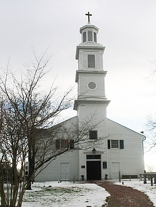
St. John's Church is an Episcopal church located at 2401 East Broad Street in Richmond, Virginia, United States. Formed from several earlier parishes, St. John's is the oldest church in the city of Richmond, Virginia. It was built in 1741 by William Randolph's son, Colonel Richard Randolph; the Church Hill district was named for it. It was the site of two important conventions in the period leading to the American Revolutionary War, and is famous as the location where American Founding Father Patrick Henry gave his memorable speech at the Second Virginia Convention, closing with the often-quoted demand, "Give me liberty, or give me death!" The church is designated as a National Historic Landmark.

Adam Thoroughgood [Thorowgood] (1604–1640) was a colonist and community leader in the Virginia Colony who helped settle the Virginia counties of Elizabeth City, Lower Norfolk and Princess Anne, the latter, known today as the independent city of Virginia Beach.
Elizabeth City was one of four incorporations established in the Virginia Colony in 1619 by the proprietor, the Virginia Company of London, acting in accordance with instructions issued by Sir George Yeardley, Governor. This allowed the crown to benefit from the offerings of the new land, including its natural resources, new markets for English goods, and the leverage it provided against the Spanish.
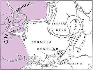
The City of Henrico is one of the oldest counties in the Colony of Virginia. It was one of four incorporations established in the colony by its proprietor, the Virginia Company. The City of Henrico, which included the settlement of Henricus, was the furthest incorporation upstream on the James River. In 1634, Henrico was reorganized under royal authority as the shire of Henrico, one of eight shires in the Crown Colony of Virginia, Later, it became known as Henrico County, Virginia.
Berkeley Hundred was a Virginia Colony, founded in 1619, which comprised about eight thousand acres (32 km2) on the north bank of the James River. It was near Herring Creek in an area which is now known as Charles City County, Virginia. It was the site of an early documented Thanksgiving when the settlers landed in what later was the United States. In 1622, following the Indian Massacre of 1622, the colony was for a time abandoned. In the mid 18th century, it became known as Berkeley Plantation, the traditional home of the Harrison family of Virginia. In 1862, amid fighting in the Civil War, the area was the scene of the creation and first bugle rendition of present-day "Taps".
The eight Shires of Virginia were formed in 1634 in the Virginia Colony. These shires were based on a form of local government used in England at the time, and were redesignated as counties a few years later. As of 2007, five of the eight original shires were considered still extant in the Commonwealth of Virginia in essentially their same political form, although some boundaries and several names have changed in the almost 400 years since their creation.