Charles M. Braga Jr. Memorial Bridge

Last updated

Braga Bridge
Braga Bridge from Somerset, October 2020.JPG
Braga Bridge from Somerset, MA, with its 2011 blue paint job
Coordinates 41°42′23.62″N71°09′56.51″W / 41.7065611°N 71.1656972°W / 41.7065611; -71.1656972
CarriesI-195.svg I-195
Crosses Taunton River
Locale Somerset and Fall River, Massachusetts
Official nameCharles M. Braga Jr. Bridge
Characteristics
Design Continuous through truss, single intersection Warren truss with verticals. Approach spans are plate girders. [1]
Total length5,780 feet (1,760 m) [1]
Width101.3 feet (30.9 m) [1]
Height254 feet (77 m) (Height of towers)
Longest span840 ft (256 m) [1]
Clearance below 135 feet (41 m) [1]
History
Construction cost$22 million
Opened1966, 1989
Statistics
Daily traffic 80,000 - 100,000 vehicles per day
Location
Charles M. Braga Jr. Memorial Bridge

The Charles M. Braga Jr. Memorial Bridge, also known as the Braga Bridge, or simply, The Braga, is a through truss bridge that carries Interstate 195 over the Taunton River between the town of Somerset and the city of Fall River, near the mouth of the Quequechan River at the confluence with Mount Hope Bay. At just over a mile long, The Braga Bridge spans 1.25 miles (2.01 km) and is one of the longest bridges in Massachusetts. Opened to traffic on April 15, 1966, [2] it provides an important link between Providence, Rhode Island, Fall River, New Bedford, and Cape Cod.

Contents

History

The Braga Bridge under construction Braga Bridge Under Construction.jpg
The Braga Bridge under construction

Planning began in the early 1950s for a new bridge to ease the congestion of the nearby Slade's Ferry and Brightman Street Bridges, as well as to carry the proposed Cape Cod Expressway over the Taunton River. The original plan called for a "high level bridge" to be located much further north, near what is now the Veterans Memorial Bridge, with a highway passing through the north end of the city in a direct line to Wareham. [3] In 1959, the role of the new bridge was changed to carrying the new Interstate 195 over the Taunton River, connecting Providence and New Bedford. Construction of the bridge started in 1959 and finished in the spring of 1966. The bridge was named after Charles M. Braga, a Fall River native of Portuguese American descent who was killed in the attack on Pearl Harbor.

Specifications

With a total span of 5,780 feet (1,760 m), and standing 135 feet (41 m) over high water in the Taunton River, the Braga Bridge easily accommodates the high-traffic shipping lane in the river. It is approximately 101 feet (31 m) wide, enough for six lanes of traffic. The Braga Bridge spans 1.2 miles (2 kilometers)

Recent history

As the Braga Bridge approached its 25th anniversary in 1989, the Massachusetts Department of Public Works (MassDPW) undertook a comprehensive two-year rehabilitation of the span and approaches. The project included the replacement of the existing deck with a new lightweight deck overlaid with bituminous concrete. Construction crews repaired and repainted structural steel along the length of the mile-long span, a new concrete Jersey barrier was built in the center median, and "suicide fences" were built along the span.

In 2003, the Massachusetts Highway Department began what was to be a three-year, $9 million rehabilitation of the Braga Bridge. The new top concrete layer of roadway was given a latex additive that resists water seepage to reduce cracking. Originally scheduled for completion in 2005, the end of the project was first re-scheduled for 2006 because of delays associated with the nearby Government Center project along I-195 in Fall River.

In the late summer of 2009, a vote was held for the public to decide on a new color for the bridge. Over 7,000 votes were cast, with voters choosing a dark blue color over lime green (the original color), light blue, and silver. [4] The work began on the new paint job April 11, 2010, and was originally scheduled for completion in June 2011. The estimated cost for the project at one time was $13.3 million. [5] Construction work has expanded and continued into 2015 as part of the overall $197-million Route 79/Braga Bridge Improvement Project. [6] Construction-related detours and delays were expected through at least the summer of 2016. [7] In October 2016, all lanes of the bridge were open for travel and construction was finished.

Role in Fall River history

The eastern end of the bridge Interstate 195, Fall River, MA.jpg
The eastern end of the bridge

The building of the Braga Bridge changed the city of Fall River in several ways. Firstly, its location caused large scale alterations to the Quequechan River. The falls of the river, which the city is named for, were channeled into tunnels which lead directly into the Taunton River. Also, because of the right-of-way of the bridge, a portion of the river upstream was narrowed (and in one spot, divided in half), changing the characteristics of the river. Plans have sporadically appeared to recreate the falls near the bridge, though none have ever materialized. Another change caused by the path of the bridge was the replacement of the former City Hall with the current Fall River Government Center, the first government building built over an interstate. Several other streets in the city were also realigned due to the construction of the highway, as well as the removal of the historic Granite Block, Troy Mills and several buildings of the Union Mills complex

The bridge itself is now seen as one of the icons of the city, often shown in the background of photographs of Battleship Cove and other views from across the Taunton River often include the bridge, given its central location in the geography of the city. Given its role as a part of Interstate 195, it is a landmark along the route for many vacationers towards Cape Cod. It is also a vital link in the area's transportation network, as it is the main route joining the South Coast region with Providence, Rhode Island. This was never as apparent as in March 1999, when falling cement acoustical tiles from under the nearby Fall River Government Center closed the highway for a week at the end of the bridge, causing traffic delays throughout the entire region.

See also

Related Research Articles

<span class="mw-page-title-main">Fall River, Massachusetts</span> City in Massachusetts

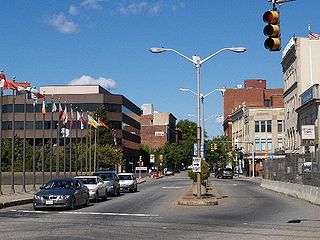
Fall River is a city in Bristol County, Massachusetts, United States. Fall River's population was 94,000 at the 2020 United States census, making it the tenth-largest city in the state.

<span class="mw-page-title-main">Charlestown High Bridge</span> Bridge in Boston, Massachusetts

The Charlestown High Bridge spanned the Charles River in Boston, Massachusetts and was part of I-93/US 1 at the north end of the Central Artery.

<span class="mw-page-title-main">Massachusetts Route 79</span> State highway in southeastern Massachusetts, US

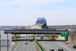
Route 79 is a 18.47-mile-long (29.72 km) state highway in southeastern Massachusetts. The route had formerly began as a highway in Fall River, also known as the Fall River Viaduct and Western Fall River Expressway, before becoming a more rural route further north. Most of the southern expressway portion of the route was permanently closed by MassDOT in 2023 for conversion into a street level urban boulevard.

<span class="mw-page-title-main">Massachusetts Route 24</span> North-south state highway in Massachusetts, US

Route 24 is a 40.91-mile-long (65.84 km) freeway south of Interstate 93 (I-93) in southeastern Massachusetts, linking Fall River with the Boston metropolitan area. It begins in the south in Fall River at the border with Tiverton, Rhode Island where it connects with Rhode Island Route 24, and runs north to an interchange with I-93/U.S. Route 1 in Randolph. Route 24 is also known as the Fall River Expressway, and officially as the Amvets Highway. Route 24 has a total of 21 interchanges

<span class="mw-page-title-main">Interstate 195 (Rhode Island–Massachusetts)</span> Highway in Rhode Island and Massachusetts

Interstate 195 (I-195) is an auxiliary Interstate Highway running a combined 44.55 miles (71.70 km) in the US states of Rhode Island and Massachusetts. It travels from a junction with I-95 in Providence, Rhode Island, east to a junction with I-495 and Massachusetts Route 25 in Wareham, Massachusetts. It runs east–west and passes through the cities of Fall River, Massachusetts, and New Bedford, Massachusetts. The portion of I-195 in East Providence is also known as the East Providence Expressway.

<span class="mw-page-title-main">Rhode Island Route 37</span> State highway in Rhode Island, US

Route 37 is a state highway running 3.47 miles (5.58 km) in Providence County and Kent County, Rhode Island, United States. A freeway for its entire length, it serves the cities of Cranston and Warwick and is also a major east–west freeway in the Providence metropolitan area, linking T. F. Green Airport with Interstate 295. The western terminus of Route 37 is an at-grade intersection with Natick Avenue in Cranston. The freeway has numbered interchanges with I-295, Rhode Island Route 2, Pontiac Avenue, and I-95 before terminating at a trumpet interchange with U.S. Route 1 in Warwick.

<span class="mw-page-title-main">Massachusetts Route 25</span> Highway in Massachusetts

Route 25 is a 10 mi (16 km)-long state highway located in Plymouth County and Barnstable County, Massachusetts, United States. The route is a nominally east–west freeway for its entire length, and less commonly known as the Blue Star Memorial Highway. An eastward continuation of Interstate 495, Route 25 provides freeway access to Cape Cod. The route's western terminus is at a trumpet interchange with I-495 and I-195 in West Wareham. The route has three numbered interchanges along its length before terminating at the northern end of the Bourne Bridge in Bourne; the mainline of Route 25 continues across the bridge and over the Cape Cod Canal as Massachusetts Route 28 south.

<span class="mw-page-title-main">Henderson Bridge (Rhode Island)</span> Bridge in Between Providence and East Providence, Rhode Island

The Henderson Bridge is a bridge in Rhode Island which spans the Seekonk River, and connects the East Side neighborhood of Providence with the Watchemoket and Phillipsdale neighborhoods of East Providence. After a major reconstruction, the bridge reopened to automobile traffic in phases from November 16 to 20, 2023. A new cycle path opened on November 27. A few weeks later, it was used as a detour during the emergency closure of the westbound half of the parallel Washington Bridge.

<span class="mw-page-title-main">Massachusetts Route 140</span> Highway in Massachusetts

Route 140 is a 107.76-mile-long (173.42 km) north—south state highway which passes through Bristol, Norfolk and Worcester counties in Massachusetts. The highway follows a southeast-northwest trajectory, running from U.S. Route 6 in New Bedford just north of Buzzards Bay northwest to an intersection with Route 12 in Winchendon, a few miles south of the border with New Hampshire.

<span class="mw-page-title-main">Washington Bridge (Providence, Rhode Island)</span> Bridge in Between Providence and East Providence, Rhode Island

The Washington Bridge is a series of three bridges carrying Interstate 195, US Route 6, US Route 44, and U.S. Route 1A over the Seekonk River connecting India Point in Providence to Watchemoket Square in East Providence, Rhode Island. The historic portion of the bridge dating to 1930 serves as the pedestrian crossing, and bike link to the East Bay Bike Path. The pedestrian span is also a part of the Washington-Rochambeau National Historic Trail. As of December 11, 2023, the westbound bridge is closed to all but emergency vehicles due to critical safety issues. On March 14, 2024, Governor Dan McKee announced that the westbound bridge cannot be repaired and will have to be replaced, requiring at least two years.

<span class="mw-page-title-main">Quequechan River</span> River

The Quequechan River is a river in Fall River, Massachusetts, that flows in a northwesterly direction from the northwest corner of the South Watuppa Pond through the heart of the city of Fall River and into the end of the Taunton River at Mount Hope Bay at Heritage State Park/Battleship Cove. The word Quequechan means "Falling River" or "Leaping/Falling Waters" in Wampanoag, hence the city's name.

<span class="mw-page-title-main">Brightman Street Bridge</span> Bridge in Somerset to Fall River, Massachusetts

The Brightman Street Bridge is a 922-foot (281 m) long, four-lane wide drawbridge spanning the Taunton River between the town of Somerset and the city of Fall River, Massachusetts. It was authorized in 1903 by the state legislature, and building took place between 1906 and 1908, when it opened full-time on October 10, 1908. It was closed to vehicular traffic on October 11, 2011.

<span class="mw-page-title-main">Piscataqua River Bridge</span> Bridge in Portsmouth, New Hampshire and Kittery, Maine

The Piscataqua River Bridge is a through arch bridge that crosses the Piscataqua River, connecting Portsmouth, New Hampshire with Kittery, Maine, United States. Carrying six lanes of Interstate 95, the bridge is the third modern span and first fixed crossing of the Piscataqua between Portsmouth and Kittery. The two other spans, the Memorial Bridge and the Sarah Mildred Long Bridge, are both lift bridges, built to accommodate ship traffic along the Piscataqua. The high arch design of the Piscataqua River Bridge eliminates the need for a movable roadway.

<i>The Herald News</i> Newspaper from Fall River, Massachusetts

The smaller of the two main newspapers in Massachusetts' South Coast, The Herald News is a daily newspaper based in Fall River, Massachusetts. Its coverage area includes Fall River and the nearby towns of Dighton, Freetown, Somerset, Swansea and Westport, Massachusetts; as well as Little Compton and Tiverton, Rhode Island.

<span class="mw-page-title-main">U.S. Route 6 in Massachusetts</span> Segment of American highway

U.S. Route 6 (US 6) in Massachusetts is a 117.952-mile-long (189.825 km) portion of the cross-country route connecting Providence, Rhode Island, to Fall River, New Bedford, and Cape Cod. In the Fall River and New Bedford areas, US 6 parallels Interstate 195 (I-195). On Cape Cod, US 6 is a highway interconnecting the towns of the area. The freeway section in this area is also known as the Mid-Cape Highway. The highway is also alternatively signed as the "Grand Army of the Republic Highway".

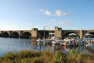
The Veterans Memorial Bridge is a bascule bridge connecting Somerset, Massachusetts and Fall River, Massachusetts. The bridge carries U.S. Route 6 and Route 138 over the Taunton River, with connecting ramps to Route 79, and includes a bike path on its north side. The $290 million bridge was dedicated to area veterans on September 11, 2011. The bike path was also dedicated in a separate ceremony that same day in honor of Pvt. Michael E. Bouthot, who was killed in action in Iraq in 2006.

<span class="mw-page-title-main">American Printing Co. and Metacomet Mill</span> United States historic place

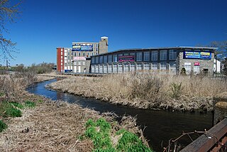
The Metacomet Mill, built in 1847 by Colonel Richard Borden for the manufacture of cotton textiles, is the oldest remaining textile mill in Fall River, Massachusetts.

<span class="mw-page-title-main">Fall River Government Center</span> Government office in United States

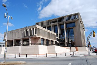
Fall River Government Center is the location of the municipal government offices in the city of Fall River, Massachusetts, United States. Located at One Government Center, and constructed directly over Interstate 195, it was the first public building built over a Federal interstate highway. It replaced the city's historic 19th century city hall which had been demolished in the early 1960s as part of the construction of Interstate 195, which cuts through the center of the city's downtown area. Delayed and plagued by problems during construction, the new city hall opened in 1976. In 2008, the building and site underwent a multimillion-dollar exterior renovation.

The Cape Cod Expressway is the name given to a highway that was proposed to have gone from New York City to Provincetown, Massachusetts. The road later became part of many highways and expressways, although it was never built and signed as a single road.

<span class="mw-page-title-main">Michael S. Van Leesten Memorial Bridge</span> Bridge in Providence, Rhode Island

The Michael S. Van Leesten Memorial Bridge is a footbridge crossing the Providence River located in the city of Providence, Rhode Island. The bridge connects Providence's Fox Point neighborhood to the city's Jewelry District. Originally known as the Providence River Pedestrian Bridge, in July 2020 it was renamed in honor of Michael S. Van Leesten.

References

  1. 1 2 3 4 5 MassHighway Charles M. Braga Bridge Archived March 11, 2007, at the Wayback Machine
  2. "Our View: The Braga Bridge turns 50".
  3. Fall River Herald News, March 18, 1953
  4. "Braga Bridge getting a new blue paint job - Fall River, MA - the Herald News". Archived from the original on September 10, 2009. Retrieved April 11, 2010.
  5. "Painting will put the squeeze on Braga Bridge project until next year".
  6. Yocono, Brian (May 31, 2015). "Braga Bridge Restoration causes traffic for miles". WPRI.com. Retrieved August 5, 2015.
  7. Spence, Colin (May 27, 2015). "Construction on the Braga Bridge to cause more detours and delays". WPRI.com. Retrieved August 5, 2015.