Chengwatana Township, Pine County, Minnesota

Last updated

Chengwatana Township, Minnesota
USA Minnesota location map.svg
Red pog.svg
Chengwatana Township, Minnesota
Location within the state of Minnesota
Usa edcp location map.svg
Red pog.svg
Chengwatana Township, Minnesota
Chengwatana Township, Minnesota (the United States)
Coordinates: 45°52′5″N92°51′49″W / 45.86806°N 92.86361°W / 45.86806; -92.86361
Country United States
State Minnesota
County Pine
Area
  Total47.3 sq mi (122.4 km2)
  Land45.8 sq mi (118.5 km2)
  Water1.5 sq mi (3.9 km2)
Elevation
928 ft (283 m)
Population
 (2000)
  Total809
  Density17.7/sq mi (6.8/km2)
Time zone UTC-6 (Central (CST))
  Summer (DST) UTC-5 (CDT)
ZIP code
55063
Area code 320
FIPS code 27-11098 [1]
GNIS feature ID0663789 [2]

Chengwatana Township is a township in Pine County, Minnesota, United States. The population was 809 at the 2000 census. Chengwatana Township was organized in 1874. [3] Its name is derived from the Ojibwe Zhingwaadena (White-pine Town), applied originally to an Ojibwe village located at the confluence of the Snake River with the St. Croix River. Neighbouring Pine City Township and the City of Pine City get their names from the English translation of Chengwatana.

Contents

Geography

According to the United States Census Bureau, the township has a total area of 47.3 square miles (123 km2), of which 45.8 square miles (119 km2) is land and 1.5 square miles (3.9 km2) (3.20%) is water.

Demographics

At the 2000 census there were 809 people, 290 households, and 218 families in the township. The population density was 17.7 inhabitants per square mile (6.8/km2). There were 480 housing units at an average density of 10.5 per square mile (4.1/km2). The racial makeup of the township was 98.15% White, 0.25% African American, 0.37% Native American, 0.25% Asian, and 0.99% from two or more races. Hispanic or Latino of any race were 0.62%. [1]

Of the 290 households, 34.8% had children under the age of 18 living with them, 62.1% were married couples living together, 6.2% had a female householder with no husband present, and 24.8% were non-families. 17.6% of households were one person, and 5.5% were one person aged 65 or older. The average household size was 2.79 and the average family size was 3.17.

In the township the population was spread out, with 26.6% under the age of 18, 10.0% from 18 to 24, 27.9% from 25 to 44, 25.2% from 45 to 64, and 10.3% 65 or older. The median age was 38 years. For every 100 females, there were 114.0 males. For every 100 females age 18 and over, there were 111.4 males.

The median household income was $41,429 and the median family income was $50,938. Males had a median income of $33,542 versus $23,269 for females. The per capita income for the township was $16,974. About 6.6% of families and 12.6% of the population were below the poverty line, including 9.5% of those under age 18 and 16.9% of those age 65 or over.

Related Research Articles

White Pine Township is a township in Aitkin County, Minnesota, United States. The population was 34 as of the 2010 census.

<span class="mw-page-title-main">Height of Land Township, Becker County, Minnesota</span> Township in Minnesota, United States

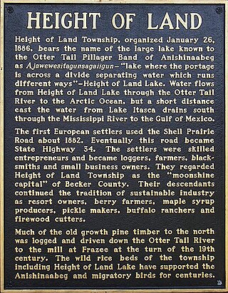
Height of Land Township is a township in Becker County, Minnesota, United States. The population was 639 as of the 2000 census.

Silver Township is a township in Carlton County, Minnesota, United States. The population was 389 as of the 2000 census. Silver Township took its name from Silver Creek.

<span class="mw-page-title-main">Crooked Lake Township, Cass County, Minnesota</span> Township in Minnesota, United States

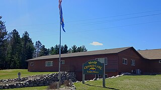
Crooked Lake Township is a township in Cass County, Minnesota, United States. The population was 498 as of the 2000 census. It is named after Roosevelt Lake, formerly known as Crooked Lake, a large lake located in this township. Crooked Lake is a translation from the Ojibwe Wewaagigamaag-zaaga'igan.

Rushseba Township is a township in Chisago County, Minnesota, United States. The population was 804 at the 2010 census.

Pine Lake Township is a township in Clearwater County, Minnesota, United States. The population was 324 at the 2000 census.

Long Lake Township is a township in Crow Wing County, Minnesota, United States. The population was 1,025 at the 2000 census.

Hamlin Township is a township in Lac qui Parle County, Minnesota, United States. The population was 185 at the 2000 census.

Madison Township is a township in Lac qui Parle County, Minnesota, United States. The population was 251 at the 2000 census.

Ottawa Township is a township in Le Sueur County, Minnesota, United States. The population was 290 at the 2000 census. Ottawa Township was organized in 1858.

Pine Lake Township is a township in Otter Tail County, Minnesota, United States. The population was 656 at the 2000 census.

Barry Township is a township in Pine County, Minnesota, United States. The population was 587 at the 2000 census.

Dell Grove Township is a township in Pine County, Minnesota, United States. The population was 699 at the 2000 census.

Kerrick Township is a township in Pine County, Minnesota, United States. The population was 272 at the 2000 census.

Kettle River Township is a township in Pine County, Minnesota, United States. The population was 491 at the 2000 census.

Nickerson Township is a township in Pine County, Minnesota, United States. The population was 154 at the 2000 census.

Norman Township is a township in Pine County, Minnesota, United States. The population was 247 at the 2000 census.

White Bear Lake Township is a township in Pope County, Minnesota, United States. The population was 440 at the 2000 census.

<span class="mw-page-title-main">Biwabik Township, St. Louis County, Minnesota</span> Township in Minnesota, United States

Biwabik Township is a township in Saint Louis County, Minnesota, United States. Biwabik is a name derived from the Ojibwe language meaning "iron". The population was 804 at the 2010 census.

Ogema Township is a township in Pine County, Minnesota, United States. The population was 298 at the 2000 census.

References

  1. 1 2 "U.S. Census website". United States Census Bureau . Retrieved January 31, 2008.
  2. "US Board on Geographic Names". United States Geological Survey. October 25, 2007. Retrieved January 31, 2008.
  3. Upham, Warren (1920). Minnesota Geographic Names: Their Origin and Historic Significance. Minnesota Historical Society. p.  411.