Related Research Articles

Greenbrier County is a county in the U.S. state of West Virginia. As of the 2010 census, the population was 35,480. Its county seat is Lewisburg. The county was formed in 1778 from Botetourt and Montgomery counties in Virginia.

Chesapeake is an independent city in the Commonwealth of Virginia. As of the 2020 census, the population was 249,422, making it the second-most populous city in Virginia.

The Elizabeth River is a 6-mile-long (10 km) tidal estuary forming an arm of Hampton Roads harbor at the southern end of Chesapeake Bay in southeast Virginia in the United States. It is located along the southern side of the mouth of the James River, between the cities of Portsmouth, Norfolk, and Chesapeake. Forming the core of the Hampton Roads harbor, it is heavily supported by its tributaries which depend upon it.
The Hampton Roads Beltway is a loop of Interstate 64 and Interstate 664, which links the communities of the Virginia Peninsula and South Hampton Roads which surround the body of water known as Hampton Roads and comprise much of the region of the same name in the southeastern portion of Virginia in the United States. It crosses the harbor of Hampton Roads at two locations on large four-laned bridge-tunnel facilities: the eastern half carries Interstate 64 and uses the Hampton Roads Bridge-Tunnel and the western half carries Interstate 664 and uses the Monitor-Merrimac Memorial Bridge-Tunnel. The beltway has the clockwise direction signed as the Inner Loop, and the counter-clockwise direction signed as the Outer Loop. The entire beltway, including the bridge-tunnels, is owned and operated by the Virginia Department of Transportation.
Interstate 264 (I-264) is an Interstate Highway in the U.S. state of Virginia. It serves as the primary east-west highway through the South Hampton Roads region in southeastern Virginia. The route connects the central business districts of Chesapeake, Portsmouth, Norfolk, and Virginia Beach and serves as the most direct link between those cities and the resort beaches along Virginia's Atlantic coast.

The West End is a part of Richmond, Virginia. Definitions of the bounds of the West End vary, it may include only the western part of the city of Richmond or extend as far as western Henrico County. As there is no one municipal organization that represents this specific region, the boundaries are loosely defined as being north of the James River, west of I-195, and south of Broad Street. Historically, the Richmond neighborhoods of the Fan and the Museum District were a part of the West End. A primary conduit through the West End is Interstate 64.
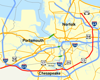
Military Highway is a four-to-eight-lane roadway built in the South Hampton Roads region of eastern Virginia, USA during World War II. Carrying US 13 for most of its length, it also carries US 58, and US 460 while in Chesapeake. It is a major alternate route for the Hampton Roads Beltway, crossing four major freeways along its length.

Indian River High School is a high school in Chesapeake, Virginia. As of the 2018-19 school year, it had approximately 1700 students.
Chesterfield County Public Schools is the public school system of Chesterfield County, Virginia, United States. As of 2020, there are about 63,000 students enrolled in 64 schools. There are 39 elementary schools, 12 middle schools, and 11 high schools. Additionally, high school students can enroll in 13 specialty centers, two technical centers, and two Governor's Schools.
The Southeastern District is a district of the Virginia High School League. The schools in the Southeastern District compete in the 6A, 5A, and 4A divisions.
Oscar F. Smith High School is a public high school with an enrollment of approximately 2,200 students in grades 9-12. The school is located on a 43-acre (170,000 m2) campus in the Greenbrier West area of the city of Chesapeake, Virginia, United States.

U.S. Route 17 is a part of the U.S. Highway System that runs from Punta Gorda, Florida to Winchester, Virginia. In Virginia, the U.S. Highway runs 255.83 miles (411.72 km) from the North Carolina state line in Chesapeake north to its northern terminus at US 11, US 50, and US 522 in Winchester. US 17 is a major highway in the eastern half of Virginia. The U.S. Highway connects the Albemarle Region of North Carolina with the Hampton Roads metropolitan area. Within the urban area, US 17 passes through the South Hampton Roads cities of Chesapeake, Portsmouth, and Suffolk and the Virginia Peninsula city of Newport News. Between Yorktown and Fredericksburg, the U.S. Highway serves as the primary highway of the Middle Peninsula. At Fredericksburg, US 17 leaves the Atlantic coastal plain; the highway passes through the Piedmont town of Warrenton and crosses the Blue Ridge Mountains on its way to Winchester in the Shenandoah Valley.The route from Tappahannock to Winchester roughly follows the Confederate March during the Civil War to Gettysburg.

Hickory High School is a high school in Chesapeake, Virginia. There are approximately 2,100 students. The mascot is a hawk and the school colors are teal, grey, white, and black.
Greenbrier is a community located in the independent city of Chesapeake, Virginia, United States. Greenbrier Parkway, a major road in Greenbrier, is the commercial hub of Chesapeake. Shopping centers line this major road, including Greenbrier Mall. Another major road, Volvo Parkway, cuts across Greenbrier Parkway. This road leads to the more residential section of Greenbrier as well as another shopping center in the opposite direction.

State Route 190 is a primary state highway in the U.S. state of Virginia. The state highway runs 15.43 miles (24.83 km) from SR 166 in Chesapeake east and north to SR 225 in Virginia Beach. SR 190 is a J-shaped route that connects the central part of Chesapeake with the western part of Virginia Beach.

The Great Indian Warpath (GIW)—also known as the Great Indian War and Trading Path, or the Seneca Trail—was that part of the network of trails in eastern North America developed and used by Native Americans which ran through the Great Appalachian Valley. The system of footpaths extended from what is now upper New York to deep within Alabama. Various Indians traded and made war along the trails, including the Catawba, numerous Algonquian tribes, the Cherokee, and the Iroquois Confederacy. The British traders' name for the route was derived from combining its name among the northeastern Algonquian tribes, Mishimayagat or "Great Trail", with that of the Shawnee and Delaware, Athawominee or "Path where they go armed".

Western Branch High School is a suburban high school in Chesapeake, Virginia, USA. Established in 1968, it currently has over 2200 students. The two feeder schools of WBHS are Joliff Middle School and Western Branch Middle School. After it was determined that redistricting due to the opening of Grassfield High School was not going to impact WBHS, a $40,000,000 construction project was funded to accommodate the larger student body and modernize the technology and facilities. This construction included a two-story wing, providing natural lighting for the students, and renovation of the rest of the school. The construction was finished in early September 2010, while the renovation of the existing school was finished in the middle 2010-2011 school year.
Grassfield High School is a public high school located in Chesapeake, Virginia, USA, and is administered by Chesapeake City Public Schools. It was built to ease overcrowding at Deep Creek High School, Great Bridge High School, and Hickory High School. Grassfield, along with Western Branch High School and Oscar Smith High School, features the latest technology available in the school district. Grassfield is also the City of Chesapeake's location for the STEM school as various high school students around the city can apply for admission into the program.
Deep Creek High School is a public secondary school in Chesapeake, Virginia. It is part of Chesapeake City Public Schools and is located on 2900 Margaret Booker Drive.
References
- ↑ Bowers, Matthew (2004-10-12). "Chesapeake reveals building plan for schools". The Virginian-Pilot . Archived from the original on 2005-04-30. Retrieved 2021-04-14.
- 1 2 Bowers, Matthew (2004-09-28). "Board weighs options to curb crowding in Chesapeake schools". The Virginian Pilot . Archived from the original on 2004-10-15. Retrieved 2021-04-14.