
The Sangro is a river in eastern central Italy, known in ancient times as Sagrus from the Greek Sagros or Isagros, Ισαγρος.

The Savio is a river in the Emilia-Romagna region of northern Italy. Its source is in the province of Forlì-Cesena near Montecoronaro on Mount Castelvecchio which is near the western side of Mount Fumaiolo. The source is at an elevation of 1,126 metres (3,694 ft) and is marked by an iron monument. A wolf and the rings of the "caveja" are on this monument. The river flows near Verghereto and Bagno di Romagna as it winds through the mountains before entering Lago di Quarto. After leaving the lake, the river flows northeast near Sarsina and Mercato Saraceno before flowing north. The river winds for 96 kilometres (60 mi) along the valley. Its natural track has been preserved relatively well and, in the territory of Cesena, it shows an environment which is one of the purest of the whole Romagna. North of Cesena, the river crossed the border into the province of Ravenna. After a total course of 126 kilometres (78 mi) the river enters the Adriatic Sea north of Cervia by Lido di Classe and Lido di Savio.
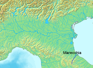
The Marecchia is a river in eastern Italy. In ancient times it was known as the Ariminus which was from the Greek Aríminos. The source of the river is near Monte dei Frati which is east of Pieve Santo Stefano and southwest of Badia Tedalda in the province of Arezzo in Tuscany. It flows northeast into the province of Pesaro and Urbino in the Marche and is the only river that runs through Montefeltro. While flowing through Montefeltro, the river flows through the exclave Santa Sofia Marecchia, which belongs to Badia Tedalda. The river then flows past Sant'Agata Feltria and Novafeltria before crossing into the province of Rimini in Emilia–Romagna. At Torello, part of the commune of San Leo, it flows 1 km west of the Sammarinese territory Acquaviva and the San Marino River flows into it, but the Marecchia does not touch the San Marino border. Finally, the river flows past Verucchio and Santarcangelo di Romagna before flowing into the Adriatic Sea near Rimini.

The Aterno-Pescara is a river system in Abruzzo, eastern central Italy. The river is known as the Aterno near its source in the mountains, but takes the name Pescara, actually a tributary, nearer the city of Pescara and the Adriatic Sea.

The Ofanto, known in ancient times as Aufidus or Canna, is a 170-kilometre (110 mi) river in southern Italy that flows through the regions of Campania, Basilicata, and Apulia, into the Gulf of Manfredonia near Barletta.

The Agri is a river in the Basilicata region of southern Italy. In ancient times it was known as Aciris. The source of the river is in the Lucan Apennines north of Monte Volturino and west of Calvello in the province of Potenza. It is near the source of the Basento. The river flows south near Paterno before curving southeast. It flows near Tramutola, Viggiano, and Grumento Nova before entering a lake. After exiting the lake, the river flows eastward near Armento, Missanello, Aliano, and Sant'Arcangelo. A right tributary, the Racanello, enters the river in this area. The river forms the border between the province of Potenza and the province of Matera for part of this area of the river. It flows into a small lake before entering the province of Matera. The river flows for a short distance before entering Lago di Gannano. After exiting the lake, the river flows southeast near Tursi, Montalbano Jonico, and Scanzano Jonico before flowing into the Gulf of Taranto near Policoro.

The Basento is a river in the Basilicata region of southern Italy. It rises at Monte Arioso in the southern Apennine Mountains, southwest of Potenza in the province of Potenza. The river flows northeast near Pignola and Potenza before curving east near Vaglio Basilicata. It curves southeast and flows near Brindisi Montagna, Trivigno, and Albano di Lucania. A right tributary coming from Lago di Ponte Fontanelle flows into the river in this area. The river forms the border between the province of Potenza and the province of Matera for a short distance before flowing into the province of Matera. It flows eastward near Tricarico, Calciano, and Grassano before curving southeast. The river flows near Grottole, Miglionico, Pomarico, Ferrandina, and Monte Finese before curving eastward. It flows near Pisticci and Bernalda before flowing into the Gulf of Taranto, which is part of the Ionian Sea, near Metaponto. The main city on the Basento is Potenza, the capital of Basilicata.

San Ginesio is a comune (municipality) in the Province of Macerata in the Italian region Marche, located about 60 kilometres (37 mi) southwest of Ancona and about 25 kilometres (16 mi) southwest of Macerata. As of 31 December 2004, it had a population of 3,872 and an area of 77.7 square kilometres (30.0 sq mi).
Serrapetrona is a comune (municipality) in the province of Macerata in the Italian region Marche, located about 60 kilometres (37 mi) southwest of Ancona and about 25 kilometres (16 mi) southwest of Macerata.

The Cesano is a river in the Marche region of Italy. Its source is near Monte Catria on the border between the province of Perugia and the province of Pesaro e Urbino. The river flows northeast through Pesaro e Urbino before forming the border between Pesaro e Urbino and the province of Ancona for a short distance. It continues flowing northeast through Pesaro e Urbino and flows past Pergola before becoming the border with Ancona again near San Lorenzo in Campo. The river flows northeast near Mondavio, Corinaldo and Monte Porzio before the province of Ancona extends westward beyond the bank of the river for a short distance near Mondolfo. Finally, the river flows into the Adriatic Sea north of Senigallia and south of Marotta and Fano.

The Tronto is a 115-kilometre (71 mi) long Italian river that arises at Monti della Laga and ends in the Adriatic Sea at Porto d'Ascoli, San Benedetto del Tronto. It traverses the Lazio, Marche, and Abruzzo regions of Italy.

The Foglia is the northernmost river of the Marche region of Italy. In ancient times it was known as Pisaurus, as it debouched into the Adriatic Sea at Pisaurum. It was also known as the Isaurus. The source of the river is west of Sestino in the province of Arezzo in the Appennino Umbro-Marchigiano mountains. It flows east through an extension of the province of Pesaro e Urbino and then back into Arezzo before forming the border between Arezzo and Pesaro e Urbino. The river then flows into the province of Pesaro e Urbino past Piandimeleto and curves northeast and flows past Sassocorvaro before curving east again. The river meanders south of Montecalvo in Foglia before curving northeast and flowing near Colbordolo, Saludecio, Sant'Angelo in Lizzola, Montecchio, Montelabbate and Tavullia before entering the Adriatic Sea near Pesaro.
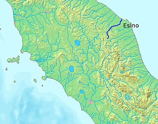
The Esino is a river in the Marche region of central Italy.
The Bradano is a river in the Basilicata and Apulia regions of southern Italy. Its source is Lago Pesole in the province of Potenza. The river flows southeast near Monte Torretta, Acerenza, and Oppido Lucano. After crossing into the province of Matera, it is joined by a right tributary, the Alvo. The river flows near Irsina before being joined by a left tributary, the Basentello. Shortly after that, it is joined by another right tributary, the Bilioso. The river then enters Lago di San Giuliano. After flowing out of the lake, the Bradano is joined by a left tributary, the Gravina, and flows southeast near Montescaglioso before entering the province of Taranto. It is then joined by a left tributary, the Gravina di Matera, before re-entering the province of Matera after a short distance. The river flows near the border with the province of Taranto before entering the Gulf of Taranto near Lido di Metaponto.

The Conca is a river in the Marche and Emilia-Romagna regions of Italy. Its source is Monte Carpegna, which is in the Montefeltro part of the province of Pesaro e Urbino. The river flows northeast near Macerata Feltria and Mercatino Conca before crossing into the province of Rimini. The river then flows past Morciano di Romagna before entering the Adriatic Sea southeast of Misano Adriatico and northwest of Cattolica.
The Carapelle is a river in the province of Foggia in the Apulia region of Italy. The source of the river is north of Anzano di Puglia near the border with the province of Avellino in the Daunian Mountains, along the Campanian Apennine. The river flows northeast near Monteleone di Puglia before curving eastward and flowing near Accadia and Sant'Agata di Puglia before being joined by a right tributary, the Calaggio. The river then curves northeast and is joined by a left tributary, the Carapellotto, before flowing past Ordona and Carapelle. The river connects with the Saline di Margherita di Savoia salt marsh via two branches on the south bank of the river before emptying into the Gulf of Manfredonia in the Adriatic Sea northwest of Zapponeta.

The Tenna is a river in the Marche region of Italy. Its source is in the Sibillini Mountains in the province of Fermo near the border with the province of Macerata. It flows northeast through the mountains near Montefortino and Amandola before forming the border between the provinces of Fermo and Macerata. The river enters the province of Fermo near Servigliano and continues flowing northeast past Grottazzolina and Montegiorgio. Finally, the river enters the Adriatic Sea near Sant'Elpidio a Mare and Porto Sant'Elpidio.

The Fiastrone is a river in the province of Macerata in the Marche region of Italy. Its source is in the Sibillini Mountains near Bolognola. The river flows northwest through the mountains before entering Lago di Fiastra. The river then exits the lake and flows northeast through the mountains. It then exits the mountains and Monti Sibillini National Park and flows north until it reaches the Chienti and enters that river by Belforte del Chienti.
The Fiastra is a river in the province of Macerata in the Marche region of Italy. Its source is in the Sibillini Mountains in Monti Sibillini National Park near Sarnano. It flows northeast near San Ginesio, Loro Piceno and Urbisaglia before entering the Chienti south of Macerata. The historic Abbadia di Fiastra is located near the river.

The Candigliano is a river in the Marche and Umbria regions of Italy. Its source is in the Appennino Umbro-Marchigiano mountains in the province of Pesaro e Urbino near the border with the province of Perugia. The river flows east and forms the border between Pesaro e Urbino and Perugia for a short distance south of Mercatello sul Metauro before entering Pesaro e Urbino. It then continues flowing east past an exclave called Monte Ruperto belonging to Città di Castello and then past Piobbico, where it is joined by the Biscubio. The river is joined by the Burano at Acqualagna and flows northeast near the Furlo Pass until it joins the Metauro west of Fossombrone.
