
Angel Island is an island in San Francisco Bay. The entire island is included within Angel Island State Park, administered by California State Parks. The island, a California Historical Landmark, has been used by humans for a variety of purposes, including seasonal hunting and gathering by indigenous peoples, water and timber supply for European ships, ranching by Mexicans, United States military installations, a United States Public Health Service Quarantine Station, and a U.S. Bureau of Immigration inspection and detention facility. The Angel Island Immigration Station, on the northeast corner of the island, which has been designated a National Historic Landmark, was where officials detained, inspected, and examined approximately one million immigrants, who primarily came from Asia. Under the Chinese Exclusion Act of 1882, the first United States law to restrict a group of immigrants based on their race, nationality, and class, all arriving Chinese immigrants were to be examined by immigration or customs agents.

The Sutro Baths was a large, privately owned public saltwater swimming pool complex in the Lands End area of the Outer Richmond District in western San Francisco, California.

The Marin Headlands are a hilly peninsula at the southernmost end of Marin County, California, United States, located just north of San Francisco across the Golden Gate Bridge, which connects the two counties and peninsulas. The entire area is part of the Golden Gate National Recreation Area. The Headlands are famous for their views of the Bay Area, especially of the Golden Gate Bridge.
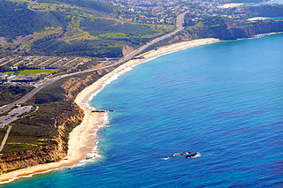
Crystal Cove State Park is a state park of California, United States, encompassing 3.2 miles (5.1 km) of Pacific coastline, inland chaparral canyons, and the Crystal Cove Historic District of beach houses. The park is located partially in Newport Beach and partially in an unincorporated area of Orange County, and is part of the larger South Coast Wilderness area. Crystal Cove is a stretch of coastal cliffs and a beachfront cove situated between the Pacific Coast Highway and the Pacific Ocean, southeast of Newport Beach and northwest of Laguna Beach. The 3,936-acre (1,593 ha) park was established in 1979. The entire park hosts a total of 3 miles of beaches and tide pools, a 1,400 acre marine Conservation Area as well as underwater park, 400 acres of bluffs, and 2,400 acres of canyons.

Baker Beach is a public beach on the peninsula of San Francisco, California, U.S. The beach lies on the shore of the Pacific Ocean in the northwest of the city. It is roughly a 0.5 mi (800 m) long, beginning just south of Golden Gate Point, extending southward toward the Seacliff peninsula, the Palace of the Legion of Honor and the Sutro Baths. The northern section of Baker Beach is "frequented by clothing-optional sunbathers," and as such it is considered a nude beach.

Crissy Field is a public recreation area on the northern shore of the San Francisco Peninsula in California, United States, located just east of the Golden Gate Bridge. It includes restored tidal marsh and beaches.

Resurrection Bay, also known as Blying Sound, and Harding Gateway in its outer reaches, is a fjord on the Kenai Peninsula of Alaska, United States. Its main settlement is Seward, located at the head of the bay. The bay received its name from Alexandr Baranov, who was forced to retreat into the bay during a bad storm in the Gulf of Alaska. When the storm settled it was Easter Sunday, so the bay and nearby Resurrection River were named in honor of it. Harding Gateway refers to the passage between Rugged and Cheval Islands.

New Brighton State Beach is a 95 acres (38 ha) beach park on Monterey Bay in Santa Cruz County, California, consisting of a beach and campgrounds. The park is located east of Santa Cruz in Capitola, on Park Avenue off of Highway 1. The park is adjacent to Seacliff State Beach, which is known for its fishing pier and sunk concrete freighter, The Palo Alto. The beach overlooks Soquel Cove and Monterey Bay.

The Golden Gate National Recreation Area (GGNRA) is a U.S. National Recreation Area protecting 82,116 acres (33,231 ha) of ecologically and historically significant landscapes surrounding the San Francisco Bay Area. Much of the park is land formerly used by the United States Army. GGNRA is managed by the National Park Service and is the second-most visited unit of the National Park system in the United States, with more than 15.6 million visitors in 2022. It is also one of the largest urban parks in the world, with a size two-and-a-half times that of the consolidated city and county of San Francisco.

Fort Baker is one of the components of California's Golden Gate National Recreation Area. The Fort, which borders the City of Sausalito in Marin County and is connected to San Francisco by the Golden Gate Bridge, served as an Army post until the mid-1990s, when the headquarters of the 91st Division moved to Parks Reserve Forces Training Area. It is located opposite Fort Point at the entrance to the San Francisco Bay.

Point Mugu State Park is a state park located in the Santa Monica Mountains National Recreation Area in Southern California. The rugged, nearly impassible shoreline of the western Santa Monica Mountains gives way to tidal lagoons and coastal sand dunes at Mugu Rock. The western edge of the park adjoins Mugu Lagoon which is a protected area within Naval Air Station Point Mugu.

Rodeo Beach is a beach in the Golden Gate National Recreation Area located in Marin County, California, United States, two miles north of the Golden Gate Bridge. It is characterized by a spit of around 50 meters width at the mouth of a long embayment, known as Rodeo Lagoon; for much of the year the lagoon is cut off from the ocean, making the beach spit a baymouth bar. Part of the beach is sheltered by cliffs. Rodeo Beach is known for its dark, pebbly sand, its uses for surfing and sunbathing, and its locale as a place for viewing, but not collecting, semi-precious stones. This beach is unique among California beaches in that it is largely made up of coarse, pebbly chert grains, both red and green in color. Its mineral composition sets it apart from every other beach in the state. Surfing is possible throughout the year and at all tidal stages, but is best in summer—although there is a risk of shark attacks. Due to the North bar offshore of this beach it results in big waves in the winter months with the big swells that come in. Strong currents make swimming dangerous.
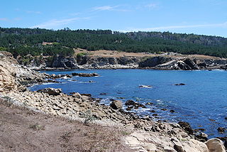
Salt Point State Park is a state park in Sonoma County, California, United States. The park covers 6,000 acres (2,428 ha) on the coast of Northern California, with 20 miles (32 km) of hiking trails and over 6 miles (9.7 km) of a rough rocky coastline including Salt Point which protrudes into the Pacific Ocean. The park also features the first underwater preserves in California. The constant impact of the waves forms the rocks into many different shapes. These rocks continue underwater providing a wide variety of habitats for marine organisms. The activities at Salt Point include hiking, camping, fishing, scuba diving and many others. The weather is often cool with fog and cold winds, even during the summer.
Founded in 1981, the Golden Gate National Parks Conservancy is a nonprofit cooperating association that supports park stewardship and conservation in the Golden Gate National Recreation Area—the most visited national park in the U.S.

Fort Funston is a former harbor defense installation located in the southwestern corner of San Francisco. Formerly known as the Lake Merced Military Reservation, the fort is now a protected area within the Golden Gate National Recreation Area (GGNRA) and is used widely as an off-leash dog park. It was named in honor of Frederick N. Funston (1865–1917), a Major General in the United States Army with strong connections to San Francisco, and included several artillery batteries. The fort is located on Skyline Boulevard at John Muir Drive, west of Lake Merced.

Lands End is a park in San Francisco within the Golden Gate National Recreation Area. It is a rocky and windswept shoreline at the mouth of the Golden Gate, situated between the Sutro District and Lincoln Park and abutting Fort Miley Military Reservation. A memorial to USS San Francisco stands in the park. Numerous hiking trails follow the former railbeds of the Ferries and Cliff House Railway along the cliffs and also down to the shore.

Kirby Cove Camp is a campground and scenic area managed by the Golden Gate National Recreation Area (GGNRA) in the Marin Headlands, California. It is located at sea level below Conzelman Road, which leads from the north end of the Golden Gate Bridge up and along the Marin Headlands overlooking the Golden Gate strait that leads into San Francisco Bay. A road behind a locked gate leads to Kirby Cove from just beyond Battery Spencer, the first set of bunkers encountered from Highway 101 at the north end of the Golden Gate Bridge.

The Tennessee Valley is a small, undeveloped part of Marin County, near Mill Valley. Historically home to ranches and threatened with the development of a new city, the valley was incorporated into the Golden Gate National Recreation Area in 1972, with additional sections added to the park in 1974. The park contains horse stables, a native-plant nursery, and numerous trails for hiking, biking, and horse riding, including a 1.7-mile, handicap-accessible trail that leads to Tennessee Cove and its beach.

Pillar Point Bluff is a 220-acre park in San Mateo County, California. It is part of the Fitzgerald Marine Reserve, owned by the U.S. state of California, and managed by San Mateo County as a county park and nature preserve. The park is located between Princeton-by-the-Sea and Moss Beach, just north of the Pillar Point peninsula, Pillar Point Harbor, and Half Moon Bay. The area was inhabited by coastal indigenous peoples for thousands of years, and in recent centuries, was used for livestock grazing by Spanish Missions and Mexican ranchos. Pillar Point Bluff was once part of the Rancho Corral de Tierra Mexican land grant before California became a state.


