
Oku is a subdivision in North West Region,, Cameroon. The term Oku also refers to the people who live in this region ruled by a Fon [King Ngum Ernest Merlin IV] and the primary language that they speak. Oku is a rural area containing about 36 villages. The nearest really large city is Bamenda, but Kumbo, which is closer, is large enough to have telephone lines and a Baptist-run hospital. Oku also has a Sub-divisional hospital. However, three mobile telephone networks are available in Oku. As such, mobile internet facilities are available.
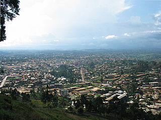
Bamenda, also known as Abakwa and Mankon Town, is a city in northwestern Cameroon and capital of the Northwest Region. The city has a population of about 2 million people and is located 366 km (227 mi) north-west of the Cameroonian capital, Yaoundé. Bamenda is known for its cool climate and scenic hilly location.

The Bamileke are a Central African people who inhabit the Bamenda Grassfields of Cameroon. They speak a Southern Bantoid language within the Bamileke language group.

Kumbo, also known as Kimbo, is the second-largest city in the North West Province of Cameroon and the capital of Bui Division. It lies about 2000m above sea level and is situated approximately 110 km away from Bamenda, on the Bamenda Highlands Ring Road. Kumbo has a population of 80,212 and is split into three distinctive hilly settlements of Tobin, Mbveh, and Squares. The town is known for horse racing and traditional medicine, and also for its palace, a market and two hospitals. Kumbo is the capital city of the Nso Kingdom of the Nso people. The lingua franca is Lamnso but Pidgin, English, Oku, Djottin, Fulfulde, and Hausa are spoken.

Bafut is a town located in a modern commune in Cameroon, it is also a traditional fondom. It is located in the Mezam Department, which in turn is located in the Northwest Province.
The Fon of Bafut is the fon or Mfor of the town of Bafut and its adjoining areas in the Northwest Province, Cameroon, which comprise the erstwhile Fondom of Bafut. At present, the Fon of Bafut is still a local ruler, but under the jurisdiction of the Government of Cameroon, and a board of Fons. Bafut is one of the largest villages in the North West Province.
The Kom are one of the principal ethnic groups of the North-West province of Cameroon, where traditional government institutions are very important. The capital, Laikom, is the seat of the ruler, the Fon, and his advisors, the Quifon, who continue to be the most respected leaders despite the imposition of a central Cameroonian government. Vincent Yuh II died in November 2017, Fon Ndzi II is the current Fon of Kom. The Cameroonian government recognizes to some degree the authority of the Fons and local chiefs subject to them.

The Far North Region, also known as the Extreme North Region, is the northernmost constituent province of the Republic of Cameroon. It borders the North Region to the south, Chad to the east, and Nigeria to the west. The capital is Maroua.
Mbengwi is the headquarters of Momo Department in the Northwest Region of Cameroon, located some 22 km from Bamenda.
The Bafut Subdivision or the Kingdom/Chiefdom/Fondom of Bafut is a commune in the Mezam Department of Northwest Province, Cameroon. It is located in the Western Grassfields region - a name for the Northwest Province and surrounding grassland areas. Bafut is the most powerful of the traditional kingdoms of the Grassfields, now divided into 26 wards along a 10 kilometre stretch of the "Ring Road" that trails along a ridge above the Menchum Valley.

Nkambe is a city in the Northwest Region of Cameroon. It is the headquarters of the Donga-Mantung department. Nkambe Central is also the name of one of the five communes in Donga-Mantung. Nkambe lies at the north edge of the Bamenda Grassfields, on the northeast arc of the Ring Road, farthest from Bamenda. The Nigerian border is only 25 or 40 km away, but roads toward the border are undeveloped jungle tracks.
Beba is a Fondom with several village communities that form part of the Benakuma sub-division in the Menchum Valley of the Northwest region of Cameroon. It is about 208 miles (335 km) from the capital city, Yaoundé. The village is accessible by a motorable road while footpaths are used to join distinct communities). Beba Fondom residents claim that their people originated from Widikum in Momo Division. They moved to Bamenda's Ntarinkon Quarter, then Mbengwi Village, later migrated to Ntamecheh and finally settled at their present location.

Guneku is a rural community in Momo Division located in the Northwest region of Cameroon, Central Africa. It has a tropical climate with 2 main seasons; the rainy and dry seasons with a population of approximately 10 000 inhabitants. The main occupations of the inhabitants are subsistence farming, and cattle rearing. Guneku has a lot of touristic sites such as the palace, caves, mountains, waterfalls, hills and valleys, rivers and springs. Guneku is one of the 31 communities that make up the Meta clan sharing boundaries with Mbemi, Nyen, Tugi, Zang-Tembeng, Oshie, Mundum and Bafut. The Bantous and Mbororos are the two tribes that cohabit peacefully in the community.
Wainamah is one of 33 villages in the town of Jakiri, Cameroon. It is the second village into Jakiri from Bamenda. It is located along the Ring Road in the North West Region of Cameroon, on a hill. It is bounded by Babessi town in Ngoketuja Division and villages like Sarkong, Ntseimban, Waarin, Limbo and Kwansoh.

Babungo is one of the four villages of Babessi Sub Division, Ngoketunjia Division of the North West Region Cameroon. It is situated on the Ring Road from Bamenda about ten kilometers from Bamunka on the high plain of Ndop which is fertile and rich in water, intensely cultivated and surrounded by a ring of hills covered with pastures, making it an ideal grazing land.

Balikumbat is a village located in Balikumbat Sub Division, Ngoketunjia Division of the North West Region, Cameroon. Balikumbat is the Sub Divisional Headquarter of Balikumbat Sub Division and located about 20.9 km from Ndop town.
Bamali village is one of the four villages that make up Ndop Central sub division and one of the thirteen villages of Ngoketunjia division of the North West region of Cameroon. Bamali village is located partly along the ring road from Bamenda some 40 km away from Bamenda town on the Bamenda-Nkambe stretch of the ring road just before reaching Bamunka.
Baba I village (Papiakum) is one of the four villages that make up Babessi subdivision and one of the thirteen villages of Ngoketunjia division of the North West region of Cameroon. Baba I village is located along the ring road from Bamenda some 50 km away from Bamenda town on the Bamenda-Nkambe stretch of the ring road just before one reaches Bamunka.
This is a timeline of the Anglophone Crisis during 2020.
This is a timeline of the Anglophone Crisis during 2021.
