Christies Beach, South Australia

Last updated

Christies Beach
Adelaide,  South Australia
Christies Beach Coastline.JPG
View of the Christies Beach coastline from Witton Bluff
Australia South Australia location map.svg
Red pog.svg
Christies Beach
Coordinates 35°08′06″S138°28′37″E / 35.134940°S 138.476960°E / -35.134940; 138.476960
Population5,962 (SAL 2021) [1]
Established1925 [2]
Postcode(s) 5165 [3]
Location26 km (16 mi) from Adelaide city centre
LGA(s) City of Onkaparinga
Region Southern Adelaide [4]
County Adelaide [5]
State electorate(s) Reynell [6]
Federal division(s) Kingston [7]
Mean max tempMean min tempAnnual rainfall
21.7 °C
71 °F
12.8 °C
55 °F
448.7 mm
17.7 in
Suburbs around Christies Beach:
Gulf St Vincent O'Sullivan Beach Lonsdale
Gulf St Vincent Christies Beach Christie Downs
Noarlunga Centre
Gulf St Vincent Port Noarlunga Noarlunga Centre
FootnotesCoordinates [2]
Location [3]
Climate [8]
Adjoining suburbs [2]

Christies Beach is a seaside suburb in the southern Adelaide metropolitan area, within the City of Onkaparinga. The area is scenic and hence popular[ citation needed ] with photographers as Witton Bluff provides a natural vantage point over the entire suburb and beyond.

Contents

Christies Beach boasts a unique commercial strip running the entire length of Beach Road and is identified as a primary coastal node in the Adelaide Metropolitan area (Planning SA, 2007). Christies Beach also features one of the few remaining main road classified Esplanades in Metropolitan Adelaide, providing direct access to the beach on Gulf St Vincent.

Christies Beach has its own postcode of 5165, and is adjacent to the suburbs of Christie Downs and Noarlunga Centre to the east, Port Noarlunga to the south, and O'Sullivan Beach to the north.

Offshore from Christies Beach is Horseshoe Reef, which is exposed at low tide. A new artificial subtidal reef was constructed approximately 500 metres offshore from the mouth of Christies Creek in 2021.

Development

The very first development to occur along the coast of Christies Beach can be traced back to pre-colonization times, almost 40,000 years ago.[ citation needed ] The indigenous Kaurna people used the coastal area of Christies Beach (at the time known as Mullawirratingga) as a place for seasonal residence. They constructed structures known as a wodli, which are small shelters made of branches and leaves. These structures were semi-permanent, only lasting the length of the summer period, after which they were then disassembled (City of Onkaparinga, 2005).

The first European development along the Christies Beach coastline was constructed in the 1830s. A whaling station was constructed along the coast, influenced by the rising price of whale bone overseas, the abundant southern right whale population during the summer breeding season and the vantage point of Gulf St Vincent from Witton Bluff. By the 1840s the seasonal whale population dwindled down to unprofitable levels with the whales changing their migration route, and the whalers left the area to pursue other activities (Colwell, 1972) (Towler, 1986).

An area of surveyed land covering Glenelg to Witton Bluff (Christies Beach) known as District B, was made available for settlement in 1838. Many farmers took plots of land along the Anderson Creek (now known as Christies Creek). In 1895 Lambert Christie and his wife Rosa established a farm that covered the area where Christies Beach is now situated. The entire area remained a land of farming communities until 1923. This is when Rosa Christie created the first subdivision in the area, it was named Christie Beach. With this subdivision and other such residential allocations in the area road and rail transportation was improved. The improvement in transportation south of Adelaide gave Christies Beach an increase in tourists and holiday makers who were looking for a coastal experience. Many tourists decided to build cottages and holiday shacks on Witton Bluff and down onto the beach itself (City of Onkaparinga, 2005).

Beach Road commercial district looking up from the beach Beach Road Christies Beach looking East.JPG
Beach Road commercial district looking up from the beach

With the influx of visitors and new residents to the area the Christies Beach Progressive Association was formed to provide good foreshore amenities, such as beach access, toilets, showers, etc. Foreshore developments led to the creation of new shops and services on the Esplanade and nearby Gulfview and Beach Roads. By the late 1950s demand for residence in the area skyrocketed, this propelled commercial and industrial developments in the Lonsdale district with the opening of Port Stanvac Oil Refinery and Chrysler (later Mitsubishi) engine plant and also in Noarlunga with the relocation of the railway line and the construction of Colonnades Shopping Centre (Colwell, 1972) (City of Onkaparinga, 2005).

Christie Beach Post Office opened on 3 April 1945 and was renamed Christies Beach around 1961. Christies Beach North office opened on 5 June 1962. [9]

Wastewater treatment plant

One of metropolitan Adelaide's three largest wastewater treatment plants exists at Christies Beach, immediately north of Christies Creek. Currently operated by SA Water, it commenced operating in 1970 and was expanded in 1981 to meet the needs of a growing population. Further expansion works were undertaken in 2013. As of 2021, the plant treats sewage for use as biogas, biosolids and recycled water, and a further portion of treated wastewater is released to the environment. [10] In the financial year 2018-19 the most significant pollutants discharged to the marine environment by mass were: nitrogen (56 tonnes), phosphorus (37 tonnes) and chlorine (6 tonnes). [11]

Future development

Existing foreshore developments include toilet facilities, benches, shelter, barbecue facilities, native vegetation plantations, fencing, informational signage, beach access stairs, and paved footpaths on both sides of the Esplanade. Recently all overhead power lines along the Esplanade have been converted to underground power lines to improve the scenic value of the foreshore. Future development plans for the Christies Beach foreshore established under the Metropolitan Coast Park Plan include the allocation of parking areas to remove on the side of the road parking, continued planting of native vegetation and the creation of more open recreation grass spaces, and converting the footpath into a multi-recreational path that can be used by walkers and cyclists alike and is connected to similar coastal paths along coasts further north and south, and changing the flow of traffic along the coast so as to turn it into a recreational road, rather than a thoroughfare. There are plans for a coastal trail from Christies Beach to Port Noarlunga, called The Witton Bluff Base Trail, with the application for funding being considered.

Sport

The central sporting hub for the Christies Beach area is the John Bice Memorial Oval, home of the Christies Beach Football Club, Southern Districts Cricket Club and the Christies Beach Sports and Social Club. At the waterfront, the Christies Beach Sailing Club and Christies Beach Surf Lifesaving Club cater for participants in aquatic sports. A small concrete boat ramp exists for launching and landing watercraft.

Historical sites

Morrow Road Bridge

The Morrow Road bridge over Christies Creek, a Local Heritage place, was once the main road bridge linking Christies Beach to O'Sullivan Beach. The structure is thought to be the only remaining example of a wooden road bridge in the former Noarlunga Council area. [12]

Morrow Road Bridge, Christies Beach, South Australia, April 2016 Morrow Road Bridge, Christies Beach, South Australia, April 2016.jpg
Morrow Road Bridge, Christies Beach, South Australia, April 2016

Parks and reserves

Lohmann Park

Situated on Galloway Road between Gulf View Road and Carmichael Road, Lohmann Park is home to The Rainmakers, a statue of bronze Aboriginal warriors. The sculpture was gifted to the people of Noarlunga City Council by Eugen Lohmann Esq., the Governing Director of Wender and Duerholt, a (West) German building company which had built a number of South Australian Housing Trust homes in the area. [13] The statue was unveiled by then Premier of South Australia, Frank Walsh, on 21 May 1965.

Also located in the park is a memorial to former City of Onkaparinga councillor Alan Oakes. [14]

D. M. Coe Reserve

Situated on an easement between Vincent Street and Dorothea Street, D. M. Coe Reserve comprises open space with a small playground. The reserve is named after Daphne Mary Coe, a councillor of the former City of Noarlunga. [15]

Ron Gill Reserve

Located on the corner of Brixton Street and Clovelly Avenue, the reserve comprises three tennis courts, a basketball ring, public toilets, open space, a small playground and the Ron Gill Memorial Hall, a community hall. The community hall is the home of the Rotary Club of Noarlunga and the Brixton Street Social Tennis Club. The reserve is named after Ron Gill, the first president of the Rotary Club of Noarlunga in 1966. [16]

Tom McBeath Reserve

Located between Vincent Street, King Street, Shepherd Road and a service road to the adjacent shops, Tom McBeath comprises open space, some trees, the Christies North Kindergarten and the hall of the disbanded 1st Christies Beach Scout Group. It is named after Tom McBeath, a former president of the Rotary Club of Noarlunga from 1970–1971, who was also a strong supporter of the nearby Christies Beach Meals on Wheels. [16]

Peters Park

The park on Archer Street was formally named Peters Park on 16 April 2019. It was named after the Peters Family in recognition of the family's long history in the neighbourhood and contribution to the park for over 55 years. [17] Allan Peters lobbied the City of Noarlunga in 1972 to landscape the park, and along with wife Pauline, daughters Ani and Leeza, and friends, decorated surrounding Stobie poles with murals, and over the years have donated their time cleaning up rubbish and reporting graffiti. [18]

Related Research Articles

<span class="mw-page-title-main">Division of Kingston</span> Australian federal electoral division

The Division of Kingston is an Australian Electoral Division in South Australia covering the outer southern suburbs of Adelaide. The 171 km² seat stretches from Hallett Cove and O'Halloran Hill in the north to Maslin Beach in the south, including the suburbs of Aberfoyle Park, Christie Downs, Christies Beach, Flagstaff Hill, Hackham, Hallett Cove, Huntfield Heights, Lonsdale, Maslin Beach, Moana, Morphett Vale, Old Noarlunga, Onkaparinga Hills, Port Noarlunga, Reynella, Seaford, Sheidow Park, Port Willunga, Trott Park, Woodcroft, and parts of Happy Valley and McLaren Flat.

<span class="mw-page-title-main">Onkaparinga River Recreation Park</span> Protected area in South Australia

Onkaparinga River Recreation Park is a protected area occupying land in the estuary of the Onkaparinga River in South Australia. The recreation park which was established in 1985 is approximately 32 km (20 mi) from Adelaide city centre. It is the venue for recreational activities such as walking, canoeing, kayaking, recreational fishing and picnics.

<span class="mw-page-title-main">Sheidow Park, South Australia</span> Suburb of Adelaide, South Australia

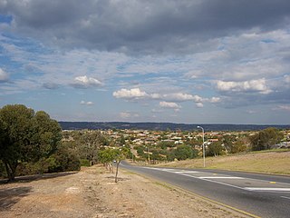
Sheidow Park is a suburb in the south of Adelaide, South Australia. The suburb is approximately 22 kilometres (14 mi) from the city-centre and is situated on coastal hills above the Adelaide Plains. The size of Sheidow Park is approximately 3.5 square kilometres. It has 9 parks covering nearly 6.1% of total area. The predominant age group in Sheidow Park is 0–9 years. Households in Sheidow Park are primarily couples with children. In general, people in Sheidow Park work in a professional occupation.

<span class="mw-page-title-main">City of Onkaparinga</span> Local government area in South Australia

The City of Onkaparinga is a local government area (LGA) located on the southern fringe of Adelaide, South Australia. It is named after the Onkaparinga River, whose name comes from Ngangkiparinga, a Kaurna word meaning women's river. It is the largest LGA in South Australia, with a population of over 170,000 people in both urban and rural communities and is also geographically expansive, encompassing an area of 518.3 km². The council is headquartered in the Noarlunga Centre with area offices situated in Aberfoyle Park, Woodcroft and Willunga.

<span class="mw-page-title-main">Onkaparinga River</span> River in South Australia

The Onkaparinga River, known as Ngangkiparri or Ngangkiparingga in the Kaurna language, is a river located in the Southern Adelaide region in the Australian state of South Australia. Rising in the Mount Lofty Ranges, the river's estuary extends from Old Noarlunga to the river's mouth between the suburbs of Port Noarlunga and Port Noarlunga South.

<span class="mw-page-title-main">Seaford line</span> Railway line in Adelaide, South Australia

The Seaford line is a suburban commuter line in Adelaide, South Australia.

<span class="mw-page-title-main">Old Noarlunga, South Australia</span> Suburb of Adelaide, South Australia

Old Noarlunga is a suburb in the Australian state of South Australia located about 30 kilometres (19 mi) south of the state capital of Adelaide. Originally settled around 1840, the town retains its village atmosphere in spite of encroaching suburbia.

<span class="mw-page-title-main">Port Noarlunga, South Australia</span> Coastal suburb of Adelaide, South Australia

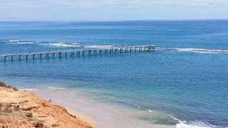
Port Noarlunga is a suburb in the City of Onkaparinga, South Australia. It is a small sea-side suburb, with a population of 2,918, about 30 kilometres to the south of the Adelaide city centre and was originally created as a sea port. This area is now popular as a holiday destination or for permanent residents wishing to commute to Adelaide or work locally. There is a jetty that connects to a 1.6 kilometres natural reef that is exposed at low tide.

<span class="mw-page-title-main">Tjilbruke</span> Creation being in Kaurna (an Aboriginal Australian group) mythology

Tjilbruke is an important creation ancestor for the Kaurna people of the Adelaide plains in the Australian state of South Australia. Tjilbruke was a Kaurna man, who appeared in Kaurna Dreaming dating back about 11,000 years. The Tjilbruke Dreaming Track or Tjilbruke Dreaming Trail is a major Dreaming trail, which connects sites from within metropolitan Adelaide southwards as far as Cape Jervis, some of which are Aboriginal sacred sites of great significance.

Christie Downs is a suburb in southern Metropolitan Adelaide within the city of Onkaparinga, South Australia. It has a unique postcode of 5164, and is adjacent to the suburbs of Christies Beach to the west, Noarlunga Centre to the south, Morphett Vale to the east and Lonsdale to the north.

<span class="mw-page-title-main">Noarlunga Centre, South Australia</span> Suburb of Adelaide, South Australia

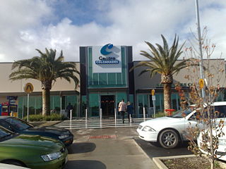
Noarlunga Centre is a suburb in the City of Onkaparinga in the southern suburbs of Adelaide, South Australia. The suburb is mostly commercial, being dominated by the Centro Colonnades shopping centre and the small 'Inspire Noarlunga' estate to the east of Goldsmith Road. The suburb is bordered by Beach Road to the north, Dyson Road to the west Goldsmith Road to the south and the Southern Expressway to the east. Burgess Drive, Seaman Road and David Witton Drive are the main thoroughfares inside the boundaries of the suburb.

<span class="mw-page-title-main">Moana, South Australia</span> Suburb of Adelaide, South Australia

Moana is an outer coastal suburb in the south of Adelaide, South Australia. The suburb is approximately 36.4 km from the Adelaide city centre. It lies within the City of Onkaparinga local government area, and neighbours the suburbs Seaford, Maslin Beach, Seaford Rise and Port Noarlunga It is divided into two by Pedler Creek and the associated sand dune reserve. The beach is often referred to as Moana Beach.

Seaford is a metropolitan suburb of Adelaide, South Australia. It lies within the City of Onkaparinga. Seaford railway station is the southern terminus of the Seaford railway line from Adelaide railway station.

Noarlunga Downs is a metropolitan suburb of Adelaide, South Australia. It lies within the City of Onkaparinga and has postcode 5168.

O'Sullivan Beach is a seaside suburb in the southern Adelaide metropolitan area, within the City of Onkaparinga. O'Sullivan Beach has a unique postcode of 5166.

Port Noarlunga South is a suburb in the Australian state of South Australia located in the Adelaide metropolitan area on the coastline of Gulf St Vincent about 30 kilometres south of the state capital of Adelaide.

Southern Times Messenger is a weekly suburban newspaper in Adelaide, part of the Messenger Newspapers group. The Southern Times' area stretches from Lonsdale in the north, through to Sellicks Beach in the south, and covers the southern suburbs, accessible from the city via Main South Road and the more recently constructed Southern Expressway. The newspaper generally reports on events of interest in its distribution area, including the suburbs of Morphett Vale, Noarlunga, Reynella and Aldinga. It also covers the City of Onkaparinga council. It has a circulation of 57,690 and a readership of 95,000.

<span class="mw-page-title-main">Port Noarlunga Reef Aquatic Reserve</span> Protected area in South Australia

Port Noarlunga Reef Aquatic Reserve is a marine protected area in the Australian state of South Australia located in waters in Gulf St Vincent adjoining the Adelaide metropolitan area and including part of the Onkaparinga River about 28 kilometres (17 mi) south-west of the state capital of Adelaide.

References

  1. Australian Bureau of Statistics (28 June 2022). "Christies Beach (suburb and locality)". Australian Census 2021 QuickStats. Retrieved 28 June 2022.  OOjs UI icon edit-ltr-progressive.svg
  2. 1 2 3 "Search result for "Christies Beach (SUB)" (Record no. SA0013925) with the following layers selected - "Suburbs and Localities" and " Place names (gazetteer)"". Property Location Browser. Government of South Australia. Archived from the original on 12 October 2016. Retrieved 2 November 2016.
  3. 1 2 "Christies Beach, South Australia (Postcode)". postcodes-australia.com. Retrieved 13 November 2016.
  4. "Southern Adelaide SA Government region" (PDF). The Government of South Australia. Archived from the original (PDF) on 27 March 2019. Retrieved 17 April 2017.
  5. "Search result for "County of Adelaide, CNTY" with the following data sets selected - "Counties" and "Local Government Areas"". Property Location SA Map Viewer. Government of South Australia. Retrieved 24 April 2017.
  6. "District of Reynell Background Profile". ELECTORAL COMMISSION SA. 2014. Retrieved 28 July 2015.
  7. "Map of the Federal division of Kingston" (PDF). Australian Electoral Commission. 2011. Retrieved 28 July 2015.
  8. "Monthly climate statistics: Summary statistics Noarlunga (nearest weather station)". Commonwealth of Australia , Bureau of Meteorology. Retrieved 11 October 2016.
  9. Phoenix Auctions History. "Post Office List". hoenix Auctions. Retrieved 7 March 2021.
  10. "Christies Beach WWTP". SA Water. Retrieved 4 February 2022.
  11. "2018/2019 report for SOUTH AUSTRALIAN WATER CORPORATION, Christies Beach Wastewater Treatment Plant - Christies Beach, SA". National Pollution Inventory. Retrieved 4 January 2022.
  12. "Heritage Places - Bridge across Christie Creek". City of Onkaparinga. Retrieved 12 April 2016.
  13. "The Rainmakers". Destination:Australia. National Library of Australia. Archived from the original on 6 January 2017. Retrieved 5 January 2017.
  14. Cole, Bryan. "Alan Oakes". Monument Australia. Retrieved 5 January 2017.
  15. "Title - Corporation of the City of Noarlunga Councillor, Daphne Mary (D M) Coe, Noarlunga, S. Aust. Undated photograph". Local Studies On-Line. Noarlunga, S. Aust.: City of Onkaparinga Libraries. n.d. Retrieved 23 May 2019.
  16. 1 2 "History of the Club". Rotary Club of Noarlunga. Retrieved 29 January 2020.
  17. "Naming options for park on Archer Street, Christies Beach". Your Say. City of Onkaparinga. Retrieved 3 February 2020.
  18. "What's in a name?". City of Onkaparinga. Onkaparinga Now. 26 April 2019. Retrieved 3 February 2020.
References
A panorama of Christies Beach (seen from the south) Christies-Beach-0839-0840-0841.jpg
A panorama of Christies Beach (seen from the south)