Church Street station (MBTA)

Last updated

Church Street
Church Street station near completion (1), December 2023.jpg
Church Street station near completion in December 2023
General information
Location387 Church Street
New Bedford, Massachusetts
Coordinates 41°40′29″N70°56′22″W / 41.67472°N 70.93944°W / 41.67472; -70.93944
Line(s) New Bedford Subdivision
Platforms1 side platform (planned)
Tracks2
ConnectionsAiga bus trans.svg SRTA: 221 [1] :51
Construction
Parking354 parking spaces
Bicycle facilities22 spaces
AccessibleYes
History
Opening2024 (planned)
ClosedSeptember 5, 1958 (former station)
Previous namesAcushnet
Passengers
2030260 weekday boardings (projected) [1] :66
Planned services
Preceding station MBTA.svg MBTA Following station
East Taunton South Coast Rail New Bedford
Terminus
Location
Church Street station (MBTA)

Church Street station is an under-construction MBTA Commuter Rail station located in northern New Bedford, Massachusetts, United States. It is planned to open in 2024 as part of the first phase of the South Coast Rail project. The station will have a single side platform on the east side of the New Bedford Subdivision, along with a park and ride lot.

Contents

The former Acushnet station, located slightly to the north of the modern station site, was served by the New York, New Haven and Hartford Railroad and several predecessors until around the 1930s. A site near Kings Highway in northern New Bedford was announced as a potential South Coast Rail station in 2009. Originally to be on the west side of the tracks, the planned station was moved to the east side and renamed North New Bedford in 2019. A construction contract was issued in 2020; that year, the station was again renamed as Church Street.

Station design

The station will be located west of Church Street approximately 13 mile (0.5 km) south of Tarkiln Hill Road in northern New Bedford, about 3 miles (4.8 km) north of downtown New Bedford and 1.5 miles (2.4 km) west of Acushnet Center. It will have an 800-foot (240 m)-long accessible high-level side platform on the east side of the New Bedford Subdivision, which will have one track plus a freight siding at the station location. A 182-foot (55 m)-long canopy will cover part of the platform to provide shelter for passengers. [2] The parking lot between the platform and Church Street will have 354 parking spaces, 22 bicycle spaces, a kiss-and-ride area, and a bus stop for Southeastern Regional Transit Authority route 8. [2] [1] :51

History

Acushnet station

A postcard of Acushnet station Acushnet station postcard.jpg
A postcard of Acushnet station

The New Bedford and Taunton Railroad opened between its namesake cities in July 1840, completing a rail route between Boston and New Bedford. [3] :398Acushnet station, located at Tarkiln Hill Road north of downtown New Bedford, served the eponymous town to the east. [4] The station was located on the east side of the tracks on the north side of the street, with a freight house on the west side of the tracks. [5] Service was later consolidated under the New Bedford Railroad (1873), Boston, Clinton, Fitchburg and New Bedford Railroad (1876), Old Colony Railroad (1879), and finally the New Haven Railroad (1893). [3] :400

Passenger service on the line continued until September 5, 1958. [6] However, most local stops including Acushnet were discontinued by the 1930s; by the end of service, trains ran nonstop from New Bedford to Taunton. [7] [8] The line continued to be used for freight service by the New Haven and its successors Penn Central and Conrail, then finally as the CSX New Bedford Subdivision. [3] :400 The former station building, moved northeast to Church Street, has been reused as a private residence. [9]

South Coast Rail

Rebar cages for the platform supports in January 2022 Rebar cages for Church Street station (1), January 2022.jpg
Rebar cages for the platform supports in January 2022

In September 2008, MassDOT released 18 potential station sites for South Coast Rail, including a King's Highway station in New Bedford (at or near the former Acushnet station site). [10] A 2009 corridor plan called for the station to be located south of Kings Highway/Tarkiln Hill Road, with the existing strip mall and industrial sites around the station area replaced by mixed-use transit-oriented development. [11] On June 11, 2010, the state took ownership of the New Bedford Subdivision and several other CSX lines as part of a sale agreement. [12] By 2013, plans called for the station to be on the west side of the tracks at the site, sharing parking with an existing movie theater. [13]

In 2017, the project was re-evaluated due to cost issues. The new proposal called for King's Highway station to be part of the first phase. [14] In 2019, the planned site was moved across the tracks due to drainage and land acquisition issues, with the name changed to "North New Bedford" for clarity. [15] [16] [2] A footbridge may be later constructed to provide access from the west side of the tracks, as 40% of the expected ridership is from the west. [16] In 2020, the planned name was changed to "Church Street". [17]

A former industrial building at 387 Church Street was demolished in 2020 to make room for the station and its parking lot. [18] The MBTA awarded a $403.5-million contract for the Middleborough Secondary and New Bedford Secondary portions of the project, including Church Street station, on August 24, 2020; construction was expected to begin later in 2020 and take 37 months. [19] The line was expected to open in late 2023. [17] The station was 16% complete by February 2022, with 46% of platform foundations complete. [20] The contract was 53% complete by August 2022. [21] Opening was delayed to mid-2024 in September 2023; at that point, the station was 86% complete and expected to be finished by the end of the year. [22] [23] In April 2024, the MBTA acknowledged that a midyear opening was unlikely, but did not provide a new schedule. [24] [25]

Related Research Articles

<span class="mw-page-title-main">Oak Grove station</span> Transit station in Malden, Massachusetts, US

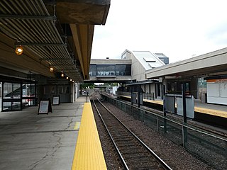
Oak Grove station is a Massachusetts Bay Transportation Authority (MBTA) intermodal transit station in the northern section of Malden, Massachusetts, just south of the Melrose border. It is the northern terminus of the rapid transit Orange Line and a stop on the Haverhill Line commuter rail service. The accessible station has a 788-space park and ride lot and is served by three MBTA bus routes.

<span class="mw-page-title-main">Route 128 station</span> Rail station in Westwood, MA

Route 128 station is a passenger rail station located at the crossing of the Northeast Corridor and Interstate 95/US Route 1/Route 128 at the eastern tip of Dedham and Westwood, Massachusetts, United States. The station is shared by Amtrak and the Massachusetts Bay Transportation Authority (MBTA). It is served by most MBTA Commuter Rail Providence/Stoughton Line trains, as well as by all Amtrak Northeast Regional and Acela intercity trains. The station building, platforms, and parking garage are all fully accessible. It is the 23rd busiest Amtrak station in the country and the fifth busiest in New England.

<span class="mw-page-title-main">Braintree station (MBTA)</span> Transit station in Braintree, Massachusetts, US

Braintree station is an intermodal transit station in Braintree, Massachusetts. It serves the MBTA's Red Line and the MBTA Commuter Rail Old Colony Lines as well as MBTA buses.

<span class="mw-page-title-main">Providence/Stoughton Line</span> Line of the Boston MBTA Commuter Rail system

The Providence/Stoughton Line is an MBTA Commuter Rail service in Massachusetts and Rhode Island, primarily serving the southwestern suburbs of Boston. Most service runs entirely on the Northeast Corridor between South Station in Boston and Providence station or Wickford Junction station in Rhode Island, while the Stoughton Branch splits at Canton Junction and terminates at Stoughton. It is the longest MBTA Commuter Rail line, and the only one that operates outside Massachusetts. The line is the busiest on the MBTA Commuter Rail system, with 17,648 daily boardings in an October 2022 count.

<span class="mw-page-title-main">Union Station (Walpole, Massachusetts)</span> Railway station in Walpole, Massachusetts, US

Union Station, also known as Walpole station, is an MBTA Commuter Rail station in Walpole, Massachusetts. It is located at the crossing of the Franklin Branch and Framingham Secondary just west of downtown Walpole. The station has one side platform on the Franklin Branch serving the Franklin/Foxboro Line service. Unlike most MBTA stations, Walpole station is not accessible.

<span class="mw-page-title-main">Middleboro Secondary</span>

The Middleboro Secondary is a railroad line owned by MassDOT in the U.S. state of Massachusetts. The line runs from Attleboro to Middleborough via Taunton.

<span class="mw-page-title-main">Readville station</span> Railway station in Boston, Massachusetts, US

Readville station is a Massachusetts Bay Transportation Authority (MBTA) commuter rail station located in the Readville section of the Hyde Park neighborhood of Boston, Massachusetts. It is served by the MBTA Commuter Rail Fairmount, Franklin/Foxboro, and Providence/Stoughton Lines. Readville is the outer terminus for most Fairmount service, though some trips continue as Franklin/Foxboro Line trains. The station is located at a multi-level junction, with the Attleboro Line tracks at ground level and the Dorchester Branch above. Franklin/Foxboro Line trains that run on the Northeast Corridor use a connecting track with a separate platform. An MBTA maintenance and storage yard and a CSX Transportation freight yard are located near the station.

<span class="mw-page-title-main">Mansfield station (MBTA)</span> Rail station in Mansfield, Massachusetts, US

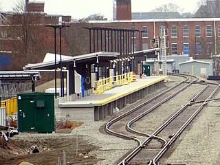
Mansfield station is an MBTA Commuter Rail station in Mansfield, Massachusetts. Located in downtown Mansfield, it serves the Providence/Stoughton Line. With 1,966 weekday boardings in a 2018 count, Mansfield is the third-busiest station on the system outside Boston.

<span class="mw-page-title-main">Forge Park/495 station</span> Rail station in Franklin, Massachusetts, US

Forge Park/495 station is a Massachusetts Bay Transportation Authority (MBTA) commuter rail station served by the Franklin/Foxboro Line. It is located off Route 140 near Interstate 495 in Franklin, Massachusetts, United States. A park and ride station serving southwestern Boston suburbs and northeastern Rhode Island, it is the outer terminus of the Franklin/Foxboro Line. The station has two side platforms serving a single track, with an accessible mini-high platform and a station building on the south platform.

<span class="mw-page-title-main">Nantasket Junction station</span>

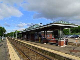
Nantasket Junction station is an MBTA Commuter Rail station in Hingham, Massachusetts. It serves the Greenbush Line. It is located off Chief Justice Cushing Highway east of downtown Hingham. It consists of a single side platform serving the line's one track. The station is fully accessible.

<span class="mw-page-title-main">Norfolk station (MBTA)</span> Rail station in Norfolk, Massachusetts, US

Norfolk station is an MBTA Commuter Rail station in Norfolk, Massachusetts, served by the Franklin/Foxboro Line. The station has one platform which serves a single track, with a mini-high section for accessibility. The Norfolk County Railroad opened through the North Wrentham village of Wrentham in 1849. A branch line to Medway was open from 1852 to 1864. The station was renamed Norfolk along with the town in 1870. Several different railroads operated the line, with the New York, New Haven and Hartford Railroad running it for much of the 20th century. Massachusetts Bay Transportation Authority (MBTA) subsidies began in 1966, and the agency bought the line in 1973. The mini-high platform was added in 1990.

<span class="mw-page-title-main">Middleborough/Lakeville station</span> Commuter rail station in Lakeville, Massachusetts, US

Middleborough/Lakeville station is an MBTA Commuter Rail station in Lakeville, Massachusetts, just south of the Middleborough border. It is the southern terminus of the Middleborough/Lakeville Line; it is also an intermediate stop for seasonal CapeFlyer service to Cape Cod. Middleborough/Lakeville has a single full-length high-level side platform serving the line's single track.

<span class="mw-page-title-main">South Coast Rail</span> Railway construction project in Massachusetts

South Coast Rail is a project to build a new southern line of the MBTA Commuter Rail system along several abandoned and freight-only rail lines. The line has been planned to restore passenger rail service between Boston and the cities of Taunton, Fall River, and New Bedford, via the towns of Berkley, and Freetown, on the south coast of Massachusetts. It would restore passenger service to some of the southern lines of the former Old Colony Railroad and the New York, New Haven and Hartford Railroad.

<span class="mw-page-title-main">East Taunton station</span> Future railway station in Taunton, Massachusetts, US

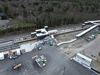
East Taunton station is an under-construction MBTA Commuter Rail station in East Taunton, Massachusetts adjacent to the interchange between the Route 24 expressway and County Street. It is planned to open in 2024 as part of the first phase of the South Coast Rail project.

<span class="mw-page-title-main">Freetown station</span> Future railway station in Freetown, Massachusetts, US

Freetown station is a future MBTA Commuter Rail station located in the Assonet village of Freetown, Massachusetts. It is planned to open in 2024 as part of the first phase of the South Coast Rail project. The station will have a single side platform on the west side of the Fall River Secondary, along with a park and ride lot.

<span class="mw-page-title-main">Fall River station</span> Railway station in Fall River, MA

Fall River station is an under-construction MBTA Commuter Rail station in Fall River, Massachusetts. The station is being constructed as part of the South Coast Rail project and is expected to open in 2024.

<span class="mw-page-title-main">Battleship Cove station</span> Planned railway station in Fall River, Massachusetts, USA

Battleship Cove is a proposed MBTA Commuter Rail station in Fall River, Massachusetts. It is planned to be the southern terminus of the Fall River branch of the South Coast Rail project, and will open in 2030 as part of the project's Phase II. The station will have no parking—it is intended for tourists visiting Battleship Cove and the Fall River waterfront, with Fall River station to the north serving commuters—and will be open seasonally. Previous passenger service to Fall River included stations at Fall River Wharf (1847–1937) and Ferry Street (1864–1958). The Wharf station was the terminus of the Fall River Line steamship service.

<span class="mw-page-title-main">New Bedford station</span>

New Bedford station is an under-construction MBTA Commuter Rail station in New Bedford, Massachusetts. The station is being constructed as part of the South Coast Rail project and is expected to open in 2024.

The Dighton and Somerset Railroad, currently referred to as the Dean Street Industrial Track, is a railroad that ran between Fall River and Braintree, Massachusetts. It opened in 1866; from the 1890s to the 1930s and again in the late 1950s, it was the primary rail route from Boston to the South Coast. Passenger service ended in stages with the final regular service in 1958, though freight service on two short segments continues into the 21st century. MBTA Commuter Rail service is proposed to be extended onto the northern part of the line around 2030 as part of the South Coast Rail project.

<span class="mw-page-title-main">Middleborough station</span> Rail station in Middleborough, Massachusetts, US

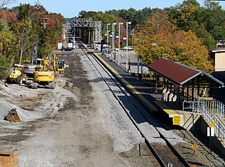
Middleborough station is an under-construction MBTA Commuter Rail station in Middleborough, Massachusetts. It is expected to open in 2024 as part of the South Coast Rail project, replacing Middleborough/Lakeville station for regular service. The station will have a single side platform located inside the wye between the Middleborough Main Line and the Middleboro Secondary.

References

  1. 1 2 3 VHB/HNTB (January 31, 2018). "Chapter 2 – Alternatives Analysis". South Coast Rail Draft Supplemental Environmental Impact Report. Massachusetts Department of Transportation.
  2. 1 2 3 "South Coast Rail - Phase 1: New Bedford Public Meeting". Massachusetts Department of Transportation. September 17, 2019.
  3. 1 2 3 Karr, Ronald Dale (2017). The Rail Lines of Southern New England (2 ed.). Branch Line Press. ISBN   9780942147124.
  4. "Plate No. 13". Atlas of Massachusetts. Geo. H. Walker & Co. 1891. pp. 134–35.
  5. "Plate 39". Atlas of the City of New Bedford, Massachusetts. Walker Lithograph & Publishing Co. 1911 via State Library of Massachusetts.
  6. Humphrey, Thomas J.; Clark, Norton D. (1985). Boston's Commuter Rail: The First 150 Years. Boston Street Railway Association. pp. 34–36. ISBN   9780685412947.
  7. "Table 31". Form 200. New York, New Haven and Hartford Railroad. September 26, 1937. p. 28.
  8. "Table 19: Boston-New Bedford-Fall River". The Scenic Shoreline Route Serving New York and New England. New York, New Haven and Hartford Railroad. April 24, 1955. p. 31 via Wikimedia Commons.
  9. LaPointe, Gary (June 9, 2021). "Bristol County".
  10. "South Coast Rail Fact Sheet" (PDF). Massachusetts Department of Transportation. October 2008. Archived from the original (PDF) on September 5, 2015.
  11. South Coast Rail Economic Development and Land Use Corridor Plan (PDF). Massachusetts Executive Office of Transportation and Executive Office of Housing and Economic Development. June 2009. p. 79. Archived from the original (PDF) on December 7, 2013.
  12. "The Massachusetts Rail Program" (PDF). Massachusetts Department of Transportation. June 2010. p. 7. Archived from the original (PDF) on May 24, 2012.
  13. "Figure 3.2-30 King's Highway Station Conceptual Station Design" (PDF). Volume II: FEIS/FEIR Figures Final Environmental Impact Statement/Final Environmental Impact Report on the South Coast Rail Project proposed by the Massachusetts Department of Transportation. U.S. Army Corps of Engineers New England District. August 2013.
  14. "Notice of Project Change" (PDF). Massachusetts Department of Transportation. March 15, 2017. Archived from the original (PDF) on April 18, 2017.
  15. Barnes, Jennette (September 6, 2019). "Proposed King's Highway train station moved to Church Street". South Coast Today. Archived from the original on September 10, 2019.
  16. 1 2 "Phase 1 New Bedford Public Information Meeting: Summary". Massachusetts Department of Transportation. September 14, 2019.
  17. 1 2 Tabakin, Jennifer (May 11, 2020). "South Coast Rail Phase 1 Update" (PDF). Massachusetts Bay Transportation Authority.
  18. Roy, Linda (August 6, 2020). "North End industrial site demolished for commuter rail station". South Coast Today. Archived from the original on August 9, 2020.
  19. "FMCB Approves $403.5 Million Contract for South Coast Rail Main Line Construction" (Press release). Massachusetts Bay Transportation Authority. August 24, 2020.
  20. "South Coast Rail Briefing for MBTA Board of Directors" (PDF). Massachusetts Bay Transportation Authority. February 24, 2022. p. 8.
  21. "South Coast Rail Fall River Construction Update" (PDF). Massachusetts Bay Transportation Authority. October 13, 2022.
  22. Medeiros, Dan (September 29, 2023). "South Coast Rail passenger service is being delayed. Here's why, explained in 60 seconds". The Herald News. Archived from the original on September 30, 2023.
  23. "South Coast Rail Shows Visible Progress" (PDF). South Coast Rail Fall 2023 Fact Sheet. Massachusetts Bay Transportation Authority. Fall 2023. p. 1.
  24. Berke, Ben (April 11, 2024). "South Coast Rail delayed again, as MBTA parts ways with project's top manager". The Public's Radio . Retrieved May 1, 2024.
  25. Medeiros, Dan (April 11, 2024). "Summer start to South Coast Rail looks 'unlikely' — but there's one bright spot for riders". The Herald News. Archived from the original on April 11, 2024.

Commons-logo.svg Media related to Church Street station (MBTA) at Wikimedia Commons