
Powys is a county and preserved county in Wales. It borders Gwynedd, Denbighshire, and Wrexham to the north; the English ceremonial counties of Shropshire and Herefordshire to the east; Monmouthshire, Blaenau Gwent, Merthyr Tydfil, Caerphilly, Rhondda Cynon Taf, and Neath Port Talbot to the south; and Carmarthenshire and Ceredigion to the west. The largest settlement is Newtown, and the administrative centre is Llandrindod Wells.

Ladybower Reservoir is a large Y-shaped, artificial reservoir, the lowest of three in the Upper Derwent Valley in Derbyshire, England. The River Ashop flows into the reservoir from the west; the River Derwent flows south, initially through Howden Reservoir, then Derwent Reservoir, and finally through Ladybower Reservoir. The reservoir is owned by Severn Trent.

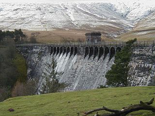
The Elan Valley Reservoirs are a chain of man-made lakes created from damming the Elan and Claerwen rivers within the Elan Valley in Mid Wales. The reservoirs, which were built by the Birmingham Corporation Water Department, provide clean drinking water for Birmingham in the West Midlands of England. The five lakes are known as the Claerwen, Craig-goch, Pen-y-garreg, Garreg-ddu, and Caban-coch.
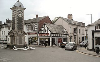
Rhayader is a market town and community in Powys, Wales, within the historic county of Radnorshire. The town is 20 miles (32 km) from the source of the River Wye on Plynlimon, the highest point of the Cambrian Mountains, and is located at the junction of the A470 road and the A44 road 13 miles (21 km) north of Builth Wells and 30 miles (48 km) east of Aberystwyth.

Lake Vyrnwy is a reservoir in Powys, Wales, built in the 1880s for Liverpool Corporation Waterworks to supply Liverpool with fresh water. It flooded the head of the Vyrnwy valley and submerged the village of Llanwddyn.

The Elan Valley is a river valley situated to the west of Rhayader, in Powys, Wales, sometimes known as the "Welsh Lake District". It covers 70 square miles (180 km2) of lake and countryside.

Perry Barr Reservoir is a covered drinking water reservoir, in north Birmingham, England, operated by Severn Trent Water. Built for the then Birmingham Corporation Water Department, on the site of the former Perry Barr Farm, it is not, despite its name, in the modern Perry Barr area, but nearby Kingstanding, at grid reference SP083951.

The Cordeaux Dam is a heritage-listed dam in Cordeaux, New South Wales, Australia. It provides water to the Macarthur and Illawarra regions, the Wollondilly Shire, and metropolitan Sydney. It is one of four dams and weirs in the catchment of the Upper Nepean Scheme. Completed in 1926 under the supervision of Ernest Macartney de Burgh, the dam is owned by Water NSW, an agency of the Government of New South Wales. It was listed on the New South Wales State Heritage Register on 18 November 1999.

Llanwrthwl is a village and community in Powys, mid Wales, and the historic county of Brecknockshire. Llanwrthwl lies off the A470 road, north by road from Builth Wells and Newbridge-on-Wye and south of Rhayader. It lies on the River Wye and River Elan and the village is accessed by a bridge over the Wye. In 1833, its population was 517; its population in 1841 was 568; in 1845, its population was 563.

The Elan aqueduct crosses Wales and the Midlands of England, running eastwards from the Elan Valley Reservoirs in Mid Wales to Birmingham's Frankley Reservoir, carrying drinking water for Birmingham.

Cwmdauddwr is a village in Powys, Wales. It is contiguous with the town of Rhayader on the opposite side of the River Wye. The village is located on the B4518 road linking Rhayader with the Elan Valley Reservoirs.
The Birmingham Corporation Water Department was responsible for the supply of water to Birmingham, England, from 1876 to 1974. It was also known as Birmingham Corporation Waterworks Department.

Elan Village is a small purpose-built community in Powys, Wales. It was designed by architect Herbert Tudor Buckland as part of Birmingham Corporation's scheme to construct a series of water supply reservoirs in the Elan Valley between 1892 and 1904. It housed workers and their families responsible for maintaining the scheme's dams and the filtration systems. Elan Village is the only purpose-built Arts and Crafts "Model Village" in Wales.
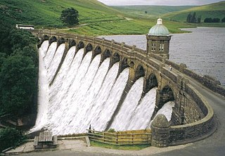
The Craig Goch Dam, often called the Top dam, is a masonry dam in the Elan Valley of Wales and creates the upper-most of the Elan Valley Reservoirs. Construction on the dam began in 1897, and it was completed in 1904. The primary purpose of the dam and the other reservoirs is to supply Birmingham with water. In 1997, a 480 kW hydroelectric generator began operation at the dam.

Elenydd is an upland area of Mid Wales, extending across parts of northern and eastern Ceredigion and Powys between Aberystwyth and Rhayader. Elenydd is also a name given to the medieval commote of Cwmwd Deuddwr which covered approximately the same area.
Monks Trod is a byway open to all traffic in Wales, developed originally by Cistercian monks between the twelfth century abbeys of Cwm-Hir, near Llandrindod Wells, and Strata Florida, near Tregaron, Ceredigion.
The Claerwen Group is a Silurian lithostratigraphic group in mid Wales. The name is derived from Claerwen in Powys where the strata are exposed. The Group comprises the Rhayader Mudstones Formation and the underlying Derwenlas Formation which outcrop across the region. The rocks of the Rhayader Mudstone Formation have variously been known as the Rhayader Pale Shales, Rhayader Pale Shales Formation and Cwmsymlog Formation.
The Grwyne Fawr Reservoir is located in the valley of the river Grwyne Fawr in the Brecon Beacons National Park, Wales. Completed in 1928, it has the capacity to hold 400,000,000 imperial gallons.
There are a large number of reservoirs in Wales reflecting the need for the supply of water for both industry and for consumption, both within the country itself and in neighbouring England. A number also provide hydroelectricity and many old reservoirs also provided motive power for industries, especially for the processing of minerals such as metal ores and slate.


