Clearwater Formation

Last updated
Clearwater Formation
Stratigraphic range: Albian
Type Geological formation
Unit of Mannville Group
Sub-units Wabiskaw Member
Underlies Grand Rapids Formation
Overlies McMurray Formation
Thicknessup to 85 metres (280 ft) [1]
Lithology
Primary Shale
Other Sandstone, siltstone
Location
Coordinates 58°00′49″N111°20′38″W / 58.01365°N 111.34377°W / 58.01365; -111.34377 (Clearwater Formation)
Regionnortheastern and central Flag of Alberta.svg  Alberta
CountryFlag of Canada (Pantone).svg  Canada
Type section
Named for Clearwater River
Named byR.G. McConnell, 1893

The Clearwater Formation is a stratigraphic unit of Early Cretaceous (Albian) age in the Western Canada Sedimentary Basin in northeastern Alberta, Canada. [2] It was first defined by R.G. McConnell in 1893 and takes its name from the Clearwater River near Fort McMurray. [3]

Contents

Impermeable marine shales in the Clearwater Formation provided part of the trapping mechanism for the underlying Athabasca oil sands in the McMurray Formation. Sandstone units in the Clearwater Formation, including the Wabiskaw Member, can contain oilsand and heavy oil resources. [1]

Nearly complete specimens of plesiosaurs and ichthyosaurs, as well as one ankylosaur, have been recovered from the formation during oilsand mining. [4]

Lithology

The Clearwater Formation consists of primarily of black and green shale, with some interbedded grey and green sandstone and siltstone, and ironstone concretions. To the southeast of Cold Lake it includes massive hydrocarbon-bearing, glauconitic salt-and-pepper sandstones with interbedded shales. [1]

Wabiskaw Member

The Wabiskaw Member forms the base of the Clearwater Formation. It consists of glauconitic sandstones with interbeds of black fissile shale, and it includes oilsand and heavy oil in some areas. [1] It was defined in well Barnsdall West Wabiskaw No. 1 (located between Wabasca River and Lesser Slave Lake in central Alberta) by P.C. Badgley in 1952. [5]

Distribution

The Clearwater Formation is present in the subsurface of northeastern and central Alberta, and is exposed on lower course of the Athabasca River, as well as along the Christina River, a tributary of the Clearwater River southeast of Fort McMurray. It reaches a maximum thickness of 85 metres (280 ft) on the Athabasca River, thins out to 6 metres (20 ft) in the Cold Lake area, and wedges out towards the south. It is not present south of Edmonton. [1]

Relationship to other units

The Clearwater Formation is part of the Mannville Group. It is conformably overlain by the Grand Rapids Formation and conformably overlies the McMurray Formation. It is equivalent to the Bluesky Formation and the lower Spirit River Formation in the Peace River region, and may be equivalent to the Cummings Member in the Lloydminster region. [1]

Paleontology

The Clearwater Formation was deposited in marine, near-shore and estuarine environments on the eastern side of the Western Interior Seaway, and it contains marine and, rarely, terrestrial fossils. Workers at mines near Fort McMurray have made a number of significant finds while removing Clearwater strata to expose underlying oilsand deposits. Plesiosaurs such as Nichollssaura and ichthyosaurs such as Athabascasaurus , some of them nearly complete, have been recovered at Syncrude Canada Ltd.'s mines. [4] [6] A well-preserved specimen of the nodosaurid Borealopelta markmitchelli has been recovered at the Suncor Millennium Mine. Plesiosaurs and ichthyosaurs were large marine reptiles, but the ankylosaur was an armoured dinosaur and represents a terrestrial animal that became entombed in the sea floor approximately 200 kilometres (120 mi) from the nearest known paleo-shoreline. Its bloated carcass probably washed out to sea and floated for several days before sinking to the sea floor. [4]

All of the specimens now reside at the Royal Tyrrell Museum of Palaeontology. [4]

Oil/gas production

The formation contains oilsand in the Cold Lake and Primrose Lake region. Heavy oil is produced from the loose sandstones of the Wabiskaw Member by means of horizontal drilling in the Wabasca oil field, and the Wabiskaw contains surface-mineable oilsand in the Fort McMurray area.

The oilsands of the Clearwater Formation are more difficult to tap than those of the McMurray Formation. Cenovus Inc.'s Tucker thermal oilsands project which opened in 2006 began to post a modest return in 2013. [7] Cenovus Inc. (CVE), with its head office in Calgary, Alberta, Canada is an integrated oil and natural gas producer.

Extraction

Cyclic Steam Stimulation (CSS)

Canadian Natural Resources use "employs cyclic steam or "huff and puff" technology to develop bitumen resources. This technology requires one well bore and the production consists of the injection and production phases. First steam is "injected for several weeks, mobilizing cold bitumen". Then the flow "on the injection well is reversed producing oil through the same injection well bore. The injection and production phases together comprise one cycle. "Steam is re-injected to begin a new cycle when oil production rates fall below a critical threshold due to the cooling of the reservoir." [8]

High pressure cyclic steam stimulation (HPCSS)

"Roughly 35 per cent of all in situ production in the Alberta oil sands uses a technique called High Pressure Cyclic Steam Stimulation (HPCSS), which cycles between two phases: first, steam is injected into an underground oilsands deposit to soften the bitumen; then, the resulting hot mixture of bitumen and steam (called a "bitumen emulsion") is pumped up to the surface. The process is then repeated multiple times." [9] An Alberta Energy Regulator (AER) news release explained the difference between high pressure cyclic steam stimulation (HPCSS) and steam assisted gravity drainage (SAGD). "HPCSS has been used in oil recovery in Alberta for more than 30 years. The method involves injecting high-pressure steam into a reservoir over a prolonged period of time. As heat softens the bitumen and water dilutes and separates the bitumen from the sand, the pressure creates cracks and openings through which the bitumen can flow back into the steam-injector wells. HPCSS differs from steam assisted gravity drainage (SAGD) operations where steam is injected at lower pressures without fracturing the reservoir and uses gravity drainage as the primary recovery mechanism." [10] Canadian Natural Resources Limited's (CNRL) Primrose and Wolf Lake in situ oil sands project near Cold Lake, Alberta in the Clearwater Formation, operated by CNRL subsidiary Horizon Oil Sands, use the high pressure cyclic steam stimulation (HPCSS).( AER 2013 )

Related Research Articles

<span class="mw-page-title-main">Oil sands</span> Type of unconventional oil deposit

Oil sands, tar sands, crude bitumen, or bituminous sands, are a type of unconventional petroleum deposit. Oil sands are either loose sands or partially consolidated sandstone containing a naturally occurring mixture of sand, clay, and water, soaked with bitumen, a dense and extremely viscous form of petroleum.

<span class="mw-page-title-main">Athabasca oil sands</span> Oil and bitumen deposits in Alberta, Canada

The Athabasca oil sands, also known as the Athabasca tar sands, are large deposits of bitumen or extremely heavy crude oil that constitute unconventional resources, located in northeastern Alberta, Canada – roughly centred on the boomtown of Fort McMurray. These oil sands, hosted primarily in the McMurray Formation, consist of a mixture of crude bitumen, silica sand, clay minerals, and water. The Athabasca deposit is the largest known reservoir of crude bitumen in the world and the largest of three major oil sands deposits in Alberta, along with the nearby Peace River and Cold Lake deposits.

Syncrude Canada Ltd. is one of the world's largest producers of synthetic crude oil from oil sands and the largest single source producer in Canada. It is located just outside Fort McMurray in the Athabasca Oil Sands, and has a nameplate capacity of 350,000 barrels per day (56,000 m3/d) of oil, equivalent to about 13% of Canada's consumption. It has approximately 5.1 billion barrels (810,000,000 m3) of proven and probable reserves situated on 8 leases over 3 contiguous sites. Including fully realized prospective reserves, current production capacity could be sustained for well over 90 years.

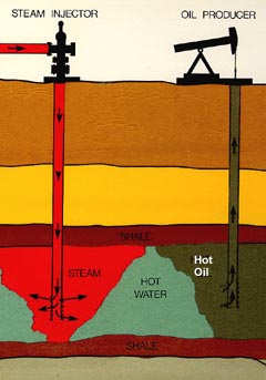
Steam-assisted gravity drainage is an enhanced oil recovery technology for producing heavy crude oil and bitumen. It is an advanced form of steam stimulation in which a pair of horizontal wells is drilled into the oil reservoir, one a few metres above the other. High pressure steam is continuously injected into the upper wellbore to heat the oil and reduce its viscosity, causing the heated oil to drain into the lower wellbore, where it is pumped out. Dr. Roger Butler, engineer at Imperial Oil from 1955 to 1982, invented the steam assisted gravity drainage (SAGD) process in the 1970s. Butler "developed the concept of using horizontal pairs of wells and injected steam to develop certain deposits of bitumen considered too deep for mining". In 1983 Butler became director of technical programs for the Alberta Oil Sands Technology and Research Authority (AOSTRA), a crown corporation created by Alberta Premier Lougheed to promote new technologies for oil sands and heavy crude oil production. AOSTRA quickly supported SAGD as a promising innovation in oil sands extraction technology.

<span class="mw-page-title-main">Wabasca oil field</span>

Wabasca is an oil field in a remote area of northern Alberta, Canada. It is the fourth largest deposit of oil sands located in Alberta, located southwest of the larger Athabasca oil sands deposit. It is also known as the Pelican Lake Oilfield.

<span class="mw-page-title-main">History of the petroleum industry in Canada (oil sands and heavy oil)</span>

Canada's oil sands and heavy oil resources are among the world's great petroleum deposits. They include the vast oil sands of northern Alberta, and the heavy oil reservoirs that surround the small city of Lloydminster, which sits on the border between Alberta and Saskatchewan. The extent of these resources is well known, but better technologies to produce oil from them are still being developed.

<span class="mw-page-title-main">Steam injection (oil industry)</span> Method of extracting heavy crude oil

Steam injection is an increasingly common method of extracting heavy crude oil. Used commercially since the 1960s, it is considered an enhanced oil recovery (EOR) method and is the main type of thermal stimulation of oil reservoirs. There are several different forms of the technology, with the two main ones being Cyclic Steam Stimulation and Steam Flooding. Both are most commonly applied to oil reservoirs, which are relatively shallow and which contain crude oils which are very viscous at the temperature of the native underground formation. Steam injection is widely used in the San Joaquin Valley of California (US), the Lake Maracaibo area of Venezuela, and the oil sands of northern Alberta,Canada.

<span class="mw-page-title-main">Fort McKay First Nation</span>

The Fort McKay First Nation (FMFN) is a First Nations government in northeast Alberta comprising five Indian reserves – Fort McKay 174, Fort McKay 174C, Fort McKay 174D, Namur Lake 174B and Namur River 174A. The FMFN, signed to Treaty 8, is affiliated with the Athabasca Tribal Council and its members are of Cree, Metis and Dene heritage. The FMFN's traditional lands include portions of the Athabasca oil sands.

Project Oilsand, also known as Project Oilsands, and originally known as Project Cauldron, was a 1958 proposal to exploit the Athabasca Oil Sands in Alberta via the underground detonation of up to 100 nuclear explosives; hypothetically, the heat and pressure created by an underground detonation would boil the bitumen deposits, reducing their viscosity to the point that standard oilfield techniques could be used.

<span class="mw-page-title-main">Bluesky Formation</span>

The Bluesky Formation is a stratigraphic unit of Lower Cretaceous age in the Western Canada Sedimentary Basin. It takes the name from the hamlet of Bluesky, and was first described in Shell's Bluesky No. 1 well by Badgley in 1952.

<span class="mw-page-title-main">McMurray Formation</span> Geological formation in Alberta, Canada

The McMurray Formation is a stratigraphic unit of Early Cretaceous age of the Western Canada Sedimentary Basin in northeastern Alberta. It takes the name from Fort McMurray and was first described from outcrops along the banks of the Athabasca River 5 kilometres (3.1 mi) north of Fort McMurray by F.H. McLearn in 1917. It is a well-studied example of fluvial to estuarine sedimentation, and it is economically important because it hosts most of the vast bitumen resources of the Athabasca Oil Sands region.

The Mannville Group is a stratigraphical unit of Cretaceous age in the Western Canadian Sedimentary Basin.

<span class="mw-page-title-main">Long Lake (oil sands)</span> Airport in Anzac

The Long Lake oil sands upgrader project is an in situ oil extraction project near Anzac, Alberta, 40 km (25 mi) southeast of Fort McMurray in the Athabasca oil sands region of Alberta.

<i>Athabascasaurus</i> Extinct genus of reptiles

Athabascasaurus is an extinct genus of platypterygiine ophthalmosaurid ichthyosaur known from Alberta, Canada.

<span class="mw-page-title-main">Canadian Natural Resources</span> Canadian hydrocarbon exploration company

Canadian Natural Resources Limited, or CNRL or Canadian Natural is a senior Canadian oil and natural gas company that operates primarily in the Western Canadian provinces of British Columbia, Alberta, Saskatchewan, and Manitoba, with offshore operations in the United Kingdom sector of the North Sea, and offshore Côte d'Ivoire and Gabon. The company, which is headquartered in Calgary, Alberta, has the largest undeveloped base in the Western Canadian Sedimentary Basin. It is the largest independent producer of natural gas in Western Canada and the largest producer of heavy crude oil in Canada.

The Grosmont Formation is a stratigraphical unit of Frasnian age in the Western Canadian Sedimentary Basin.

Laricina Energy Ltd. was a private Canadian oil producing company engaged in exploration in North-Eastern Alberta. The company targeted oil sands opportunities outside of the Athabasca mining area and was focusing on in situ plays in the Grosmont and Grand Rapids formations. Its headquarters were located in Calgary, Alberta, Canada.

<span class="mw-page-title-main">Beaver Lake Cree Nation</span> Canadian First Nation

The Beaver Lake Cree Nation is a First Nations band government located 105 kilometres (65 mi) northeast of Edmonton, Alberta, representing people of the Cree ethno-linguistic group in the area around Lac La Biche, Alberta, where the band office is currently located. Their treaty area is Treaty 6. The Intergovernmental Affairs office consults with persons on the Government treaty contacts list. There are two parcels of land reserved for the band by the Canadian Crown, Beaver Lake Indian Reserve No. 131 and Blue Quills First Nation Indian Reserve. The latter reserve is shared by six bands; Beaver Lake Cree Nations, Cold Lake First Nations, Frog Lake First Nation, Heart Lake First Nation, Kehewin Cree Nation, Saddle Lake Cree Nation.

<span class="mw-page-title-main">Peace River oil sands</span>

Located in northwest-central Alberta, the Peace River oil sands deposit is the smallest of four large deposits of oil sands of the Western Canadian Sedimentary Basin formation.

<span class="mw-page-title-main">Oil sands tailings ponds (Canada)</span> Engineered dam and dyke systems used to capture oil sand tailings

Oil sands tailings ponds are engineered dam and dyke systems used to capture oil sand tailings. Oil sand tailings contain a mixture of salts, suspended solids and other dissolvable chemical compounds such as acids, benzene, hydrocarbons residual bitumen, fine silts and water. Large volumes of tailings are a byproduct of bitumen extraction from the oil sands and managing these tailings is one of the most difficult environmental challenges facing the oil sands industry. An October 2021 Alberta Energy Regulator (AER) report said that in 2020 the tailings ponds increased by another 90 million cubic meters and contained 1.36 billion cubic metres of fluids.

References

  1. 1 2 3 4 5 6 Glass, D.J. (editor) 1997. Lexicon of Canadian Stratigraphy, vol. 4, Western Canada including eastern British Columbia, Alberta, Saskatchewan and southern Manitoba. Canadian Society of Petroleum Geologists, Calgary, 1423 p. on CD-ROM. ISBN   0-920230-23-7.
  2. Mossop, G.D. and Shetsen, I. (compilers), Canadian Society of Petroleum Geologists and Alberta Geological Survey (1994). "The Geological Atlas of the Western Canada Sedimentary Basin, Chapter 19: Cretaceous Mannville Group of the Western Canada Sedimentary Basin". Archived from the original on 2016-07-01. Retrieved 2016-06-20.{{cite web}}: CS1 maint: multiple names: authors list (link)
  3. McConnell, R.G., 1893. Report on a portion of the district of Athabasca, comprising the country between Peace River and Athabasca River north of Lesser Slave Lake. Geological Survey of Canada, Annual Report (new series), 1890-91, v. 5, Part 1, p. 1-67.
  4. 1 2 3 4 Henderson, D. (2013). "A one-in-a-billion dinosaur find". The Guardian. Retrieved 2013-11-21.
  5. Badgley, Peter C., 1952. Notes on the subsurface stratigraphy and oil and gas geology of the Lower Cretaceous series in central Alberta (Report and seven figures); Geological Survey of Canada, Paper No. 52-11, page 12
  6. Syncrude Canada Ltd. (2012). "Another fossil unearthed at Syncrude's North Mine". Syncrude Canada Ltd. Archived from the original on 2013-12-03. Retrieved 2013-11-21.
  7. Calgary Herald (January 8, 2013). "Tucker oilsands project posts rare return".
  8. "Cyclic Steam Stimulation". Thermal in situ oil sands. CNRL. 2013. Archived from the original on 2015-10-16. Retrieved 2013-07-30.
  9. Severson-Baker, Chris (29 July 2013). "Cold Lake bitumen blowout first test for new energy regulator".
  10. "Alberta Energy Regulator orders enhanced monitoring and further steaming restrictions at Primrose and Wolf Lake projects due to bitumen emulsion releases". AER. 18 July 2013. Archived from the original on 30 July 2013. Retrieved 30 July 2013.