Climate of Istanbul

Last updated
Istanbul (Kireçburnu, Sarıyer)
Climate chart (explanation)
J
F
M
A
M
J
J
A
S
O
N
D
 
 
96
 
 
9
4
 
 
88
 
 
9
4
 
 
70
 
 
12
5
 
 
45
 
 
16
8
 
 
37
 
 
21
13
 
 
45
 
 
26
17
 
 
36
 
 
28
20
 
 
44
 
 
28
21
 
 
81
 
 
25
17
 
 
98
 
 
20
14
 
 
101
 
 
15
9
 
 
125
 
 
11
6
Average max. and min. temperatures in °C
Precipitation totals in mm
Source: NOAA [1]
Imperial conversion
JFMAMJJASOND
 
 
3.8
 
 
48
38
 
 
3.5
 
 
49
38
 
 
2.7
 
 
54
41
 
 
1.8
 
 
61
47
 
 
1.5
 
 
70
55
 
 
1.8
 
 
78
63
 
 
1.4
 
 
82
69
 
 
1.7
 
 
83
70
 
 
3.2
 
 
76
63
 
 
3.9
 
 
68
56
 
 
4
 
 
59
49
 
 
4.9
 
 
51
42
Average max. and min. temperatures in °F
Precipitation totals in inches
A view of the Bosporus from Kirecburnu, mid-winter. Kirecburnu Sahili.JPG
A view of the Bosporus from Kireçburnu, mid-winter.

The climate of Istanbul , classified variously as Mediterranean, oceanic, or a transitional climate between the two, is temperate; with cool, frequently rainy, somewhat snowy winters, and warm to hot, moderately dry summers. Strongly influenced by the Sea of Marmara to the south and the Black Sea to the north, it is thoroughly maritime; precipitation is moderately high, fog is frequent, and seasonal lag is noticeable both in winter and in summer. The city is sheltered from both extreme heat and frigid temperatures, with temperatures rarely reaching 33 °C (91 °F) or dipping below −6 °C (21 °F), [2] and is quite windy year-round.

Contents

Precipitation is unevenly distributed, with winter generally experiencing very frequent precipitation, while summers are generally dry, punctuated by infrequent showers. Cloudiness also varies drastically by season; while the city has winters that receive around one fifth of the possible sunshine duration, comparable to cities in northwestern Europe, in summer the city gets considerably more sunshine than most of Western and Central Europe.

Istanbul's climate is rapidly changing due to the combined effects of climate change and the city's urban heat island. Recent data shows an immense increase in daily low temperatures, and some increase in daily highs.

General climate

Temperature

A graph showing the lowest temperature recorded annually in Goztepe, Kadikoy from 1929 to 2003. Note the faster increase post-1980, due to both climate change and Istanbul's urban heat island. TNn, Istanbul.png
A graph showing the lowest temperature recorded annually in Göztepe, Kadıköy from 1929 to 2003. Note the faster increase post-1980, due to both climate change and Istanbul's urban heat island.

Istanbul's average temperature is, by the latest normals covering 1991-2020, around 14 °C (57 °F); placing the city on the warmer end of the temperate zone. Its coldest month is usually February, with an average temperature of 5–6 °C (41–43 °F), while its warmest month is usually August, with an average temperature of 23–24 °C (73–75 °F). Unsurprisingly, Istanbul's temperature range is narrow for a non-oceanside locale; the annual mean maximum (hottest temperature in an average year), is about 33 °C (91 °F), while the annual mean minimum (coldest temperature in an average year) is about −6 °C (21 °F). [2] Istanbul's climate is also well known for its noticeable seasonal lag; it is one of the few cities in the temperate Northern Hemisphere where March is, in many districts, colder than December. [3]

Summers in the city are dominated by stable, northeasterly meltem -like air, with a narrow range of daytime temperatures, generally around 25 °C (77 °F) to 32 °C (90 °F). A temperature of 38 °C (100 °F) is only seen around once every ten years. [2] Despite this, Istanbul's summer climate is generally seen as relatively uncomfortable, largely due to persistently high dew points; most thermal comfort indices rate July and August to be less comfortable overall than June and September. [4]

Winters are more variable; still with relatively stable daytime temperatures generally around 2 °C (36 °F) to 14 °C (57 °F), but with abrupt, short-term extremes. The dominant northeasterly loses its dry quality in this time of year, giving way to a more moist wind, termed Poyraz (ultimately from Ancient Greek : Βορρᾶς, romanized: Borrhâs) from the same direction, causing persistent precipitation, sometimes in the form of snow; although still incapable of producing extreme cold due to its maritime nature. [5] [6] The Lodos (ultimately from Ancient Greek : Νότος, romanized:  Nótos ) is the southwesterly, warm and dry wind "competing" with the northeasterly Poyraz, and is responsible for the occasional day above 15 °C (59 °F) [lower-alpha 1] in the city, as well as numerous severe windstorms. [7] Therefore, while warmth records in winter are usually associated with and always colloquially blamed on the Lodos, cold records are the product of rare windless nights. [5]

Spring and fall are mild, especially by the end of spring and the beginning of fall. Spring is generally colder than fall due to seasonal lag; March is quite chilly, much more akin to winter, in contrast to November's milder average temperatures. The last spring frost generally happens around late March in the most coastal and heavily urbanized areas, and late April well-inland; the first fall frost happens sometime in November in most of the city (except the far western suburbs, which may get their first frost in October), and early December in coastal locations. [8]

It is somewhat well-established that summer mean temperatures have risen from about 20–22 °C (68–72 °F) during pre-industrial times, to about 23–25 °C (73–77 °F) over the last two centuries, according to reconstructions done by Luterbacher et al. [9] The same pattern is not found to the same extent in winter, where temperatures have seen no perceptible increase until very recently. [10] This points to the combined effect of climate change and the urban heat island, which increases in intensity during the nights of the city's largely sunny summer days, and in hot summer days may create temperature differences of up to 8 °C at night, essentially creating a 4-5 °C difference between urban and rural areas. [11]

Wind

Istanbul is quite windy; with average yearly wind speeds of 18–36 km/h (11–22 mph) depending on location, it is quite anomalous for a city that is not in the immediate west-coast of a continent. [12] These high averages are not caused by frequent windstorms however; they are rather caused by the near-constant north-northeasterly wind over the city (specifically the etesians in summer, and the Poyraz in winter) that all but eliminates windless days and cause around 30 days with sustained wind speeds above 57 km/h (35 mph) per year. [5] [13] [14]

Although rare, Istanbul can experience severe windstorms, mostly due to Lodos in winter, when the typical wind-flow reverses and becomes southwesterly. These have, historically, created gusts of up to 150 km/h (93 mph). [15] Most years, however, see gusts up to 80–100 km/h (50–62 mph), which rarely causes more than sporadic damage. [13]

Precipitation

Severe snowstorms are not uncommon in Istanbul. As of 2024, the winter storm of January 2022 remains the latest storm to cause accumulations above 30 centimetres (1 ft) of snow in the entire city. This photo is, however, from an earlier, 2012 event. Istanbul - panoramio (10).jpg
Severe snowstorms are not uncommon in Istanbul. As of 2024, the winter storm of January 2022 remains the latest storm to cause accumulations above 30 centimetres (1 ft) of snow in the entire city. This photo is, however, from an earlier, 2012 event.

Istanbul's precipitation varies considerably between years and districts. On average, however, it experiences around 800 millimetres (31 in) of precipitation annually. Most of this falls in the colder half-year, with around 100 millimetres (4 in) to 150 millimetres (6 in) of precipitation in the wettest months. In the driest months, precipitation ranges from 10 millimetres (0.4 in) to 75 millimetres (3 in) depending on location, month and year, with prolonged dry periods punctuated by abrupt, heavy showers and thunderstorms, sometimes severe.

As Istanbul receives some amount of precipitation from both Atlantic and Mediterranean systems, precipitation, especially in the winter half-year, is frequent and light, which is unusual for the Mediterranean basin: the average number of rainy days in the city is 131, and in some parts this may reach up to 152. Furthermore, during early and mid-winter, the city's frequency of precipitation is virtually unparalleled in the Mediterranean basin; January averages 20 days of precipitation when counting trace accumulations, [16] 17 when using a 0.1 mm threshold, and 12 when using a 1.0 mm threshold, on par with cities such as Brussels, and rainier than famously humid locales in Western Europe, such as London. [17]

Rain remains the dominant form of precipitation throughout the year, with snow representing only one fourth of precipitation even in the coldest months of January and February. [16] Despite this, an annual average of more than 60 centimeters (24 in) of snow falls on the area of the airport, making Istanbul the snowiest major city in the Mediterranean basin. [2] [18] Snowfall varies widely between years and different areas of the city, with districts facing north more prone to receive snow than southerly ones. This effect is largely caused by lake-effect snow, which forms when cold air, originating from the North Pole or Siberia, develops into moist and unstable air that ascends to form snow squalls along the lee shores of the Black Sea, upon contact with the relatively warm water. [3] These snow squalls are heavy snow bands and occasionally thundersnows, with accumulation rates approaching 5–8 centimeters (2–3 in) per hour. [19] Almost half of snowy periods do not leave accumulated snow for more than a day, reducing the 'number of days with snow cover' statistic, published daily [lower-alpha 2] by the TSMS, by half. [20] [21]

Particularly severe winter storms have included January 1942, March 1987, and most recently January 2017 and 2022. [22] Some of these broke daily snow depth [lower-alpha 3] records, with 80 centimeters (2.6 ft; 31 in) on 4 January 1942, and 104 centimeters (3.41 ft; 41 in) in the northern suburbs on 11 January 2017; unofficial measurements in hilly and northern regions have included 85 centimeters (2.79 ft; 33 in) in March 2022, and a putative measurement of 4 meters (13 ft; 160 in) in some snow drifts in March 1987. [23] [3] [24] [25]

Normally uncommon precipitation types, especially graupel (Turkish : Kar paleti, lit. 'Snow pellets', colloquially: Bulgur, lit. ' Grains of cracked wheat ' or Kuzudişi, ' Deciduous teeth ') are a staple of winter due to insufficient cooling of the southern Black Sea, somewhat well known internationally for delaying a Champions League match between Galatasaray and Juventus. [lower-alpha 4] [26] [27]

Sunshine and cloudiness

Morning fog on the outskirts of the city. Fog often avoids urban areas and high hills in Istanbul. BAHCESEHIR SABAHI 2 - panoramio.jpg
Morning fog on the outskirts of the city. Fog often avoids urban areas and high hills in Istanbul.

Istanbul's sunshine is profoundly seasonal, with cloudy winters and mostly sunny summers. Yearly, it averages around 2000 hours of sunshine; cloudier than the rest of the Mediterranean and generally similar to southern oceanic and sub-Mediterranean locales, like the Pacific Northwest in the US or areas around the Bay of Biscay in France.

In winter, the city is known for its persistently cloudy weather, with many regions getting less than 20 percent of their potential sunlight, and winter months of certain years getting less than 30 hours – equivalent to less than one tenth of possible sunshine. [28] This brings Istanbul's sunshine hours to levels closer to Western Europe, while its generally sunny summers create a seasonal sunshine pattern perhaps most closely mirrored by Cascadia, specifically Seattle.

Fog is known to be a major component limiting sunshine in Istanbul. Data before 1980 count annual foggy and misty days at above 200, and in some summer months, records show more than 25 days of fog and mist. [29] [30] This has had cultural implications, most famously on poetry; an "obstinate mist" ( Ottoman Turkish : دودمعند, romanized: dûd-ı mu'annid) symbolizes the persistently oppressive nature of Abdülhamid II's Istanbul in Tevfik Fikret's "The Fog" ( Modern Turkish : Sis). [31]

However, fog has been steadily declining since the 1970s. Data from the 1980s show around 100 days of fog and mist, and this has declined to about 60 in the last 10 years. [32] This is likely due to the city's urban heat island, which has been raising overnight temperatures since the city's initial rapid expansion in the 1950s and 60s. [33] While forested regions outside the city (especially in nearby Kocaeli Province) have lagged behind in the decrease of fog – the station in Gölcük had consistently been seeing over 200 days of fog until 1993, and now also averages around 60 – the decrease of fog poses a significant threat to the flora of the region, which feed on morning humidity in the relatively dry summer months. [34]

Severe weather

Istanbul's climate is generally not conducive to severe weather, due to its maritime heating and cooling. However, instances of severe weather do occur in Istanbul with some regularity, mostly in the form of heavy snow, [lower-alpha 5] severe thunderstorms and heatwaves.

Thunderstorms

Istanbul experiences around 10-15 days of thunderstorms per year, relatively low for non-Atlantic Europe. Mean annual number of days with thunderstorms (in Europe).jpg
Istanbul experiences around 10-15 days of thunderstorms per year, relatively low for non-Atlantic Europe.

Istanbul experiences around 10–15 days of thunderstorms, with a primary peak in June, and another one in September. [35] Unlike many central European cities, July and August are too dry to support a high amount of thunderstorms, and yet unlike many cities in the Mediterranean basin, winters are too cold and cloudy to support thunderstorms, causing two warm-season stormy periods with a summerly nadir in between. [35]

Despite the relatively uncommon nature of thunderstorms in the city, a notable anomaly is the amount of strong to severe [lower-alpha 6] thunderstorms that occur yearly; about half of the thunderstorms that occur in the city (about 6–7) can be qualified as such. [35] These thunderstorms peak around early-fall, likely due to warmer waters; while their anomalously high number is likely due to high wind shear and other conditions conducive to severe storm development. [35] [36]

Very damaging storms have happened on a somewhat consistent basis, a significant one in recent memory is the July 2017 storm, where 9 cm (3.5 in) hail causing damage to buildings, straight line winds of 100 kilometres per hour (62 mph) and widespread flooding was recorded. [37] [38] [39] Tornadoes, even weak ones, are very uncommon, nevertheless not impossible, with recent storms in 2020 and 2021 dropping weak, non-damaging tornadoes. [40]

Heat waves

Due to its maritime position, Istanbul is not susceptible to heat waves by southern European standards. Not only do cities with cooler summers [lower-alpha 7] often have higher summer temperature records than Istanbul, Istanbul escapes heat-waves even when they happen over northwestern Turkey. Most recently in September 2022, when southern Marmara was experiencing daily highs of about 37–38 °C (99–100 °F), Istanbul's high temperature was 29 °C (84 °F), with a strong northeasterly wind. [41] [42]

However, studies have shown that heatwaves, when they do happen, can and do cause excess death in the largely unprepared population. Four heat waves in the years 2013 to 2017, two of which happened in the year 2017, where every summer month anomalously experienced at least one day above 36 °C (97 °F), show that excess deaths do increase substantially during heatwaves. [43]

Sea temperatures

Unsurprisingly, Istanbul's sea temperatures are warmer than its climate, in accordance with its place in the general Mediterranean region; this generally means that places farther away from the sea experience colder weather, especially in winter. Its 'cool but not cold' winter sea temperatures also have a major effect on the city's precipitation, especially on sea-effect snow. [19]

Climate data for Istanbul
MonthJanFebMarAprMayJunJulAugSepOctNovDecYear
Average sea temperature °C (°F)8.4

(47.1)

7.7

(45.9)

8.3

(46.9)

10.2

(50.4)

15.5

(59.9)

21.3

(70.3)

24.6

(76.3)

24.9

(76.8)

22.8

(73.0)

18.4

(65.1)

13.8

(56.8)

10.5

(50.9)

15.5

(60.0)

Source: Weather Atlas [44]

Classification

Istanbul: Climate according to major climate systems
Climatic schemeInitialsDescription
Köppen system [45] Csa/Cfa/Cfb Hot-summer Mediterranean climate, Humid subtropical climate , Oceanic climate
Trewartha system [46] Cs/Cf/Do Mediterranean climate, Humid subtropical climate , Oceanic climate
Alisov system [47]
PmSm
Mediterranean climate, Oceanic climate [lower-alpha 8]
Strahler system [48]
8
Oceanic climate
Thornthwaite system [49]
B1 B'2
Humid, mild mesothermal climate [lower-alpha 9]
Neef system [50] Mediterranean climate , Temperate transitional climate

The transitional nature of Istanbul's climate causes divergence in classification and nomenclature. According to Köppen and Trewartha, Istanbul has a borderline Mediterranean climate, humid subtropical climate and oceanic climate. Thornthwaite classifies most of the city as B1 B'2 s b'4, [lower-alpha 10] while the semi-official Atalay system classifies it as a Mediterranean-oceanic transitional climate. [51] Other nomenclature used to classify the city include 'Temperate transitional climate' and 'sub-continental-sub-Mediterranean transition climate'. [52]

In stark contrast to the divergence in classification in generalist classifications, precipitation-based classifications generally concur that Istanbul is moist subhumid in the south and humid in the north. Only the Aydeniz aridity classification diverges from this, calling the city 'humid to perhumid', largely due to high relative humidity and fog. [53]

Areas and microclimates

Microclimates of Istanbul according to Koppen-Geiger classification system. Istanbul Koppen Map.png
Microclimates of Istanbul according to Köppen–Geiger classification system.

Because of its hilly topography and maritime influences, Istanbul exhibits a multitude of distinct microclimates. [54] Average temperatures range from 12 °C (54 °F) to 15 °C (59 °F) depending on location, rainfall varies widely from around 600 millimeters (24 in) on the southern fringe at Florya to 1,200 millimeters (47 in) on the northern fringe at Bahçeköy, and sunshine ranges from 2300 hours to 1800 hours (comparable to Portland, Oregon and Bournemouth respectively) depending on location. [55]

Furthermore, while the city itself lies in USDA hardiness zones 9a to 9b, its inland suburbs lie in zone 8b with isolated pockets of zone 8a, restricting the cultivation of subtropical plants to the coasts. [56] [57]

Marmara coast

Vegetation on the Marmara coast is low-growing due to summer drought. Aydos 800x524.jpg
Vegetation on the Marmara coast is low-growing due to summer drought.

The warmest and driest region of Istanbul, the Marmara coast is considered to have a Mediterranean climate by both Köppen and Trewartha. Bohn, however, considers the area sub-Mediterranean as with the rest of Istanbul, and comments that the region is "protected from cold winds due to their location on southern slopes at the sea, [has] very high water deficiency in summer." [52] Thornthwaite also considers the region "s2", "with considerable summer drought".

Its summers are some of the hottest in the province, with summerly means reaching 25 °C (77 °F) in July and August in some areas; although Bohn argues that if the region had not been thoroughly urbanized, this value would have been 20 °C (68 °F) to 23 °C (73 °F). [52]

Winter temperatures are also higher, with daily means of about 6 °C (43 °F) in January and February over the lowlands, while some hills experience average temperatures around 4 °C (39 °F). [52] The area largely lies in USDA hardiness zones 9a and 9b, with temperatures rarely falling below −5 °C (23 °F). [56]

Rainfall is generally around 600 millimetres (24 in) to 800 millimetres (31 in) throughout the region, although rainy days increase from west to east, with Pendik getting around 12 more days of precipitation than Florya. [58] [59] The area is also relatively snow-poor, with less than 10 days of snow in all parts of the region, [58] around half of which accumulates and stays on the ground for more than a day. [20]

Sunshine ranges from 2000 to 2300 hours, with a notable west–east gradient, the eastern side being more cloudy. [59]

Climate data for Florya, Bakırköy, Istanbul (normals 1991–2020, extremes 1937–present, sunshine 1981-2010)
MonthJanFebMarAprMayJunJulAugSepOctNovDecYear
Record high °C (°F)20.5
(68.9)
21.0
(69.8)
26.0
(78.8)
30.5
(86.9)
33.5
(92.3)
36.2
(97.2)
37.4
(99.3)
38.6
(101.5)
39.5
(103.1)
32.3
(90.1)
26.4
(79.5)
23.1
(73.6)
39.5
(103.1)
Mean daily maximum °C (°F)9.2
(48.6)
9.8
(49.6)
12.4
(54.3)
17.1
(62.8)
22.2
(72.0)
26.8
(80.2)
29.5
(85.1)
29.7
(85.5)
25.8
(78.4)
20.8
(69.4)
15.8
(60.4)
11.1
(52.0)
19.2
(66.5)
Daily mean °C (°F)6.2
(43.2)
6.3
(43.3)
8.3
(46.9)
12.2
(54.0)
17.2
(63.0)
22.0
(71.6)
24.7
(76.5)
25.0
(77.0)
21.1
(70.0)
16.7
(62.1)
12.1
(53.8)
8.1
(46.6)
15.0
(59.0)
Mean daily minimum °C (°F)3.7
(38.7)
3.6
(38.5)
5.3
(41.5)
8.6
(47.5)
13.4
(56.1)
17.8
(64.0)
20.5
(68.9)
21.1
(70.0)
17.4
(63.3)
13.6
(56.5)
9.3
(48.7)
5.7
(42.3)
11.7
(53.0)
Record low °C (°F)−12.6
(9.3)
−10.0
(14.0)
−9.6
(14.7)
−1.4
(29.5)
1.4
(34.5)
8.4
(47.1)
11.0
(51.8)
11.4
(52.5)
6.7
(44.1)
1.8
(35.2)
−4.6
(23.7)
−11.5
(11.3)
−12.6
(9.3)
Average precipitation mm (inches)72.0
(2.83)
78.8
(3.10)
61.0
(2.40)
51.5
(2.03)
30.2
(1.19)
31.5
(1.24)
19.8
(0.78)
26.1
(1.03)
44.7
(1.76)
80.4
(3.17)
69.3
(2.73)
87.3
(3.44)
648.0
(25.51)
Average extreme snow depth cm (inches)7.0
(2.8)
7.5
(3.0)
1.1
(0.4)
0
(0)
0
(0)
0
(0)
0
(0)
0
(0)
0
(0)
0
(0)
trace1.2
(0.5)
12.4
(4.9)
Average precipitation days (≥ 0.1 mm)18.316.815.510.69.06.33.33.27.311.813.517.2132.8
Average snowy days (≥ 0.1 cm)2.73.50.60.00.00.00.00.00.00.00.21.08.0
Average relative humidity (%)79.178.475.773.173.170.368.269.771.877.278.378.974.5
Mean monthly sunshine hours 89.3103.4154.8198.2279.0286.2310.7284.2201.7152.1112.083.32,254.9
Mean daily sunshine hours 2.83.64.96.69.09.510.09.16.74.93.72.66.1
Percent possible sunshine 28324050646366655544372848
Source: [60] [61] [62] [63] [64]
Climate data for Kurtköy, Pendik, Istanbul (more data in the district article)
MonthJanFebMarAprMayJunJulAugSepOctNovDecYear
Mean daily maximum °C (°F)9.3
(48.7)
10.0
(50.0)
11.8
(53.2)
16.9
(62.4)
21.7
(71.1)
26.2
(79.2)
28.5
(83.3)
28.3
(82.9)
25.1
(77.2)
19.9
(67.8)
15.7
(60.3)
11.7
(53.1)
18.8
(65.8)
Daily mean °C (°F)6.1
(43.0)
6.7
(44.1)
8.0
(46.4)
12.4
(54.3)
16.8
(62.2)
21.0
(69.8)
23.3
(73.9)
23.3
(73.9)
20.3
(68.5)
15.9
(60.6)
12.1
(53.8)
8.5
(47.3)
14.5
(58.2)
Mean daily minimum °C (°F)2.8
(37.0)
3.3
(37.9)
4.1
(39.4)
7.8
(46.0)
11.8
(53.2)
15.8
(60.4)
18.1
(64.6)
18.3
(64.9)
15.4
(59.7)
11.8
(53.2)
8.4
(47.1)
5.3
(41.5)
10.2
(50.4)
Average precipitation mm (inches)97.5
(3.84)
79.8
(3.14)
64.0
(2.52)
55.9
(2.20)
52.0
(2.05)
46.4
(1.83)
24.0
(0.94)
43.4
(1.71)
58.3
(2.30)
59.9
(2.36)
62.6
(2.46)
88.6
(3.49)
732.4
(28.84)
Average precipitation days (≥ 0.1 mm)181614121194710121417144
Average snowy days (≥ 0.1 cm)2310000000017
Mean monthly sunshine hours 63.680.8123.1170.0226.3266.6279.8265.8199.5158.5104.672.02,010.6
Mean daily sunshine hours 2.12.83.95.67.38.89.08.66.75.13.42.35.5
Percent possible sunshine 21253243525860615546342643
Source: [65] [66] [67] [68]

Inland from the Bosporus

The Bosporus provides an important channel for winds, creating heavy gusts along its shores. Sirketten Bogaz - panoramio.jpg
The Bosporus provides an important channel for winds, creating heavy gusts along its shores.

The climate near the Bosporus is cooler, wetter and cloudier, and represents a good average of the region of Istanbul. It is classified as humid subtropical by both Köppen and Trewartha, although non-urbanized and hilly regions are mostly oceanic, as most of the region likely was before urbanization. [52] Bohn further comments on this region by stating that, starting here, the precipitation regime is profoundly impacted by the Black Sea. [52]

The coldest month generally averages around 5–6 °C (41–43 °F), with a USDA hardiness zone of 8b and 9a, while the warmest month seems to have experienced significant warming from 20–22 °C (68–72 °F) to 23–24 °C (73–75 °F). [56] [52] Despite this, summer days are still relatively acceptable at around 27–28 °C (81–82 °F), with most of the warming happening during nighttime.

Precipitation generally averages around 800 millimetres (31 in) to 1,000 millimetres (39 in), with the Anatolian side getting more precipitation. [69] The lack of a real summer drought, with at least 30 mm (1.2 in) of precipitation every month, further distinguishes this region from the south. Snowfall is generally plentiful, due to the relatively continental nature of the region.

Sunshine is a bit lower than the southern coast, usually around 2000–2200 hours, yet still higher than the northern coasts.

Climate data for Kireçburnu, Sarıyer, Istanbul (normals 1991–2020, precipitation days and sunshine 1981-2010, snowy days 1996-2011)
MonthJanFebMarAprMayJunJulAugSepOctNovDecYear
Record high °C (°F)22.4
(72.3)
24.6
(76.3)
29.3
(84.7)
33.6
(92.5)
36.4
(97.5)
40.2
(104.4)
41.5
(106.7)
40.5
(104.9)
39.6
(103.3)
34.2
(93.6)
27.8
(82.0)
25.5
(77.9)
41.5
(106.7)
Mean daily maximum °C (°F)8.8
(47.8)
9.4
(48.9)
12.0
(53.6)
16.1
(61.0)
21.0
(69.8)
25.7
(78.3)
28.0
(82.4)
28.2
(82.8)
24.6
(76.3)
19.9
(67.8)
15.0
(59.0)
10.7
(51.3)
18.3
(64.9)
Daily mean °C (°F)5.9
(42.6)
6.1
(43.0)
8.0
(46.4)
11.5
(52.7)
16.3
(61.3)
21.1
(70.0)
23.7
(74.7)
24.2
(75.6)
20.5
(68.9)
16.2
(61.2)
11.7
(53.1)
7.9
(46.2)
14.4
(58.0)
Mean daily minimum °C (°F)3.6
(38.5)
3.5
(38.3)
4.9
(40.8)
8.1
(46.6)
12.8
(55.0)
17.4
(63.3)
20.3
(68.5)
21.2
(70.2)
17.4
(63.3)
13.6
(56.5)
9.2
(48.6)
5.5
(41.9)
11.5
(52.6)
Record low °C (°F)−13.9
(7.0)
−16.1
(3.0)
−11.1
(12.0)
−2.0
(28.4)
1.4
(34.5)
7.1
(44.8)
10.5
(50.9)
10.2
(50.4)
6.0
(42.8)
0.6
(33.1)
−7.2
(19.0)
−11.5
(11.3)
−16.1
(3.0)
Average precipitation mm (inches)96.1
(3.78)
87.7
(3.45)
69.8
(2.75)
45.1
(1.78)
37.1
(1.46)
44.7
(1.76)
36.3
(1.43)
43.5
(1.71)
81.3
(3.20)
98.3
(3.87)
100.5
(3.96)
124.8
(4.91)
865.2
(34.06)
Average precipitation days (≥ 0.1 mm)16.915.213.210.07.47.04.75.18.112.313.917.5131.3
Average snowy days (≥ 0.1 cm)4.54.72.90.10.00.00.00.00.00.00.32.715.2
Average relative humidity (%)79.878.675.875.176.575.775.375.975.078.478.978.476.9
Mean monthly sunshine hours 68.289.6142.6180.0248.0297.6319.3288.3234.0158.193.062.02,180.7
Mean daily sunshine hours 2.23.24.66.08.09.610.39.37.85.13.12.05.9
Percent possible sunshine 22293846576469666546312246
Source: [3] [70] [44] [71]
Climate data for Kandilli, Üsküdar, Istanbul
MonthJanFebMarAprMayJunJulAugSepOctNovDecYear
Mean daily maximum °C (°F)7.9
(46.2)
8.0
(46.4)
10.4
(50.7)
15.5
(59.9)
20.2
(68.4)
24.9
(76.8)
27.1
(80.8)
27.0
(80.6)
23.8
(74.8)
19.0
(66.2)
14.6
(58.3)
10.5
(50.9)
17.4
(63.3)
Daily mean °C (°F)5.2
(41.4)
5.1
(41.2)
7.0
(44.6)
11.3
(52.3)
15.8
(60.4)
20.2
(68.4)
22.7
(72.9)
22.8
(73.0)
19.6
(67.3)
15.4
(59.7)
11.3
(52.3)
7.8
(46.0)
13.7
(56.6)
Mean daily minimum °C (°F)2.4
(36.3)
2.2
(36.0)
3.5
(38.3)
7.1
(44.8)
11.3
(52.3)
15.4
(59.7)
18.2
(64.8)
18.5
(65.3)
15.3
(59.5)
11.7
(53.1)
8.0
(46.4)
5.0
(41.0)
9.9
(49.8)
Average precipitation mm (inches)103
(4.1)
83
(3.3)
69
(2.7)
45
(1.8)
37
(1.5)
36
(1.4)
32
(1.3)
39
(1.5)
69
(2.7)
96
(3.8)
101
(4.0)
128
(5.0)
838
(33.1)
Source: [72] [73]

Northern hills and valleys

Belgrad Forest in Bahcekoy, consisting of mixed oak and beech, is the wettest place in Istanbul. Beograd Orman agaclar - panoramio.jpg
Belgrad Forest in Bahçeköy, consisting of mixed oak and beech, is the wettest place in Istanbul.

The northern third of Istanbul is the wettest part of the city. It is considered borderline humid subtropical (Cfa/Cf) and oceanic (Cfb/Do), though the oceanic zone is rapidly shrinking, and the driest parts of the region in and around Kilyos can be considered on the wet fringes of a Mediterranean (Csa/Cs) climate. Bohn characterizes the climate as a "moist-temperate (...) by mostly north and northeastern winds by the Black Sea; [with] frequent formation of thew [sic] and mists in summer." [52]

Summer averages are generally around 21–23 °C (70–73 °F), with locales closer to the coast experiencing very narrow diurnal temperature ranges. Winter averages depend on proximity to the coast; inland parts of the region have averages around 4 °C (39 °F) while coastal regions see winter temperatures close to the rest of the city. Accordingly, USDA hardiness zones are equally variable, from 9a around the coast to 8a in some inland valleys. [56]

Precipitation is variable, with averages ranging from 800 millimetres (31 in) to 1,200 millimetres (47 in), depending on location. Rainy days, more plentiful than the rest of the city, show the usual east–west gradient; with Şile getting up to 15 days more precipitation than Bahçeköy. Also notable is the sheer frequency of precipitation in some areas, as Şile averages above 20 days of precipitation in December.

Snowfall is plentiful due to proximity to the Black Sea coast, although along the coast the snowy season is shorter, with only around 1 day of snow in March.

Sunshine data in this region is relatively scarce, but the station in Kilyos averages around 1800 hours of sunshine, making it the cloudiest recorded area of Istanbul. [74]

Climate data for Bahçeköy, Sarıyer, Istanbul (normals 1981–2010, snowy days 1990-1999)
MonthJanFebMarAprMayJunJulAugSepOctNovDecYear
Mean daily maximum °C (°F)7.6
(45.7)
8.3
(46.9)
10.2
(50.4)
16.4
(61.5)
20.6
(69.1)
25.0
(77.0)
26.4
(79.5)
26.6
(79.9)
23.7
(74.7)
19.0
(66.2)
14.2
(57.6)
9.8
(49.6)
17.3
(63.2)
Daily mean °C (°F)4.6
(40.3)
4.0
(39.2)
5.9
(42.6)
10.3
(50.5)
15.4
(59.7)
19.8
(67.6)
21.5
(70.7)
21.6
(70.9)
18.1
(64.6)
14.1
(57.4)
9.5
(49.1)
6.3
(43.3)
12.6
(54.7)
Mean daily minimum °C (°F)1.3
(34.3)
1.1
(34.0)
2.5
(36.5)
6.4
(43.5)
10.6
(51.1)
14.7
(58.5)
17.0
(62.6)
17.9
(64.2)
13.9
(57.0)
10.7
(51.3)
6.8
(44.2)
3.4
(38.1)
8.9
(47.9)
Average precipitation mm (inches)163.7
(6.44)
112.5
(4.43)
101.3
(3.99)
68.3
(2.69)
55.8
(2.20)
47.4
(1.87)
45.3
(1.78)
71.9
(2.83)
79.6
(3.13)
119.0
(4.69)
164.3
(6.47)
188.3
(7.41)
1,217.4
(47.93)
Average precipitation days (≥ 0.1 mm)15.814.212.910.18.36.95.85.97.412.615.419.8135.1
Average snowy days (≥ 0.1 cm)4.65.21.70.40.00.00.00.00.00.00.34.016.2
Source: [75] [76]
Climate data for Şile, Istanbul
MonthJanFebMarAprMayJunJulAugSepOctNovDecYear
Mean daily maximum °C (°F)9.2
(48.6)
9.8
(49.6)
12.1
(53.8)
15.9
(60.6)
20.6
(69.1)
25.3
(77.5)
27.7
(81.9)
27.9
(82.2)
24.6
(76.3)
19.9
(67.8)
15.3
(59.5)
11.0
(51.8)
18.3
(64.9)
Daily mean °C (°F)5.8
(42.4)
6.0
(42.8)
7.9
(46.2)
11.3
(52.3)
16.0
(60.8)
20.7
(69.3)
23.3
(73.9)
23.8
(74.8)
20.1
(68.2)
15.9
(60.6)
11.4
(52.5)
7.6
(45.7)
14.2
(57.5)
Mean daily minimum °C (°F)2.9
(37.2)
2.9
(37.2)
4.4
(39.9)
7.5
(45.5)
12.0
(53.6)
16.1
(61.0)
18.9
(66.0)
19.8
(67.6)
16.1
(61.0)
12.5
(54.5)
8.1
(46.6)
4.7
(40.5)
10.5
(50.9)
Average precipitation mm (inches)87.5
(3.44)
73.7
(2.90)
70.3
(2.77)
45.5
(1.79)
32.3
(1.27)
39.7
(1.56)
37.6
(1.48)
62.5
(2.46)
79.3
(3.12)
110.2
(4.34)
85.3
(3.36)
117.0
(4.61)
840.9
(33.1)
Average precipitation days (≥ 0.1 mm)18.815.313.712.411.69.25.06.77.912.516.820.2150.1
Average snowy days (≥ 0.1 cm)4.34.40.50.00.00.00.00.00.00.00.12.611.9
Average relative humidity (%)81.080.278.078.481.280.980.980.679.181.780.980.880.3
Source: [77] [78] [79]

See also

Notes

  1. In northern parts of the city, Lodos functions as a Foehn wind, which can raise temperatures further to around 20 °C (68 °F) in rare occurrences. See the extreme temperature graph for information on this.
  2. This is crucial, as the measurement, made in 9am local time, does not count the snow that has fallen and melted over the previous 24 hours.
  3. Not snowfall, as these are not published officially.
  4. This was widely believed to be snow or hail, although it was neither.
  5. Extensively covered in the Precipitation section.
  6. The definition used for 'severe thunderstorm' in this study is less strict than the US definition, generally including all thunderstorms that can cause damage; strong to severe is likely the correct US equivalent.
  7. Paris is likely the most well-known example.
  8. Depending on the version used, Istanbul's dominant airmasses are Moist Polar air in winter, and Moist or Dry Subtropical air in summer. The most recent evaluations give credence to Moist Subtropical, resulting in the climate designation PmSm, equivalent to an Oceanic climate.
  9. More info in the paragraph below.
  10. A humid, mild mesothermal climate with moderate summer drought and very low continentality.

Related Research Articles

<span class="mw-page-title-main">Subarctic climate</span> Climate characterised by long, usually very cold winters, and short, cool summers

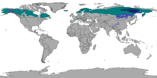
The subarctic climate is a continental climate with long, cold winters, and short, warm to cool summers. It is found on large landmasses, often away from the moderating effects of an ocean, generally at latitudes from 50°N to 70°N, poleward of the humid continental climates. Subarctic or boreal climates are the source regions for the cold air that affects temperate latitudes to the south in winter. These climates represent Köppen climate classification Dfc, Dwc, Dsc, Dfd, Dwd and Dsd.

<span class="mw-page-title-main">Climate of the United Kingdom</span> Climate of the country

The United Kingdom straddles the higher mid-latitudes between 49° and 61°N on the western seaboard of Europe. Since the UK is always in or close to the path of the polar front jet stream, frequent changes in pressure and unsettled weather are typical. Many types of weather can be experienced in a single day.

<span class="mw-page-title-main">Humid continental climate</span> Category in the Köppen climate classification system

A humid continental climate is a climatic region defined by Russo-German climatologist Wladimir Köppen in 1900, typified by four distinct seasons and large seasonal temperature differences, with warm to hot summers, and cold and snowy winters. Precipitation is usually distributed throughout the year, but often these regions do have dry seasons. The definition of this climate in terms of temperature is as follows: the mean temperature of the coldest month must be below 0 °C (32.0 °F) or −3 °C (26.6 °F) depending on the isotherm, and there must be at least four months whose mean temperatures are at or above 10 °C (50 °F). In addition, the location in question must not be semi-arid or arid. The cooler Dfb, Dwb, and Dsb subtypes are also known as hemiboreal climates. Although amount of snowfall is not a factor used in defining the humid continental climate, snow during the winter in this type of climate is almost a guarantee, either intermittently throughout the winter months near the poleward or coastal margins, or persistently throughout the winter months elsewhere in the climate zone.

Oklahoma City lies in a temperate humid subtropical climate, with frequent variations in weather daily and seasonally, except during the consistently hot and humid summer months. Consistent winds, usually from the south or south-southeast during the summer, help temper the hotter weather. Consistent northerly winds during the winter can intensify cold periods. Oklahoma City's climate transitions toward semi-arid further to the west, toward humid continental to the north, and toward humid subtropical to the east and southeast. The normal annual mean temperature is 61.4 °F (16.3 °C); the coolest year was 1895 with a mean of 57.9 °F (14.4 °C), while the warmest 2012 at 64.1 °F (17.8 °C). Precipitation averages 36.52 inches (928 mm) annually, falling on an average 84 days, with the warmer months receiving more; annual precipitation has historically ranged from 15.74 in (400 mm) in 1901 to 56.95 in (1,447 mm) in 2007. The sun shines about 69% of the time, with monthly percent possible sunshine ranging from 60% in December to 80% in July.

<span class="mw-page-title-main">Climate of Alaska</span> Overview of the climate of the U.S. state of Alaska

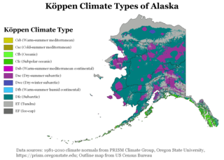
The climate of Alaska is determined by average temperatures and precipitation received statewide over many years. The extratropical storm track runs along the Aleutian Island chain, across the Alaska Peninsula, and along the coastal area of the Gulf of Alaska which exposes these parts of the state to a large majority of the storms crossing the North Pacific. The climate in Juneau and the southeast panhandle is a mid-latitude oceanic climate, in the southern sections and a subarctic oceanic climate in the northern parts. The climate in Southcentral Alaska is a subarctic climate due to its short, cool summers. The climate of the interior of Alaska is best described as extreme and is the best example of a true subarctic climate, as the highest and lowest recorded temperatures in Alaska have both occurred in the interior. The climate in the extreme north of Alaska is an Arctic climate with long, cold winters, and cool summers where snow is possible year-round.

<span class="mw-page-title-main">Climate of Italy</span> Overview of climatic conditions in Italy

The climate of Italy is highly diverse. In most of the inland northern and central regions, the climate ranges from humid subtropical to humid continental and oceanic. The climate of the Po valley geographical region is mostly humid subtropical, with cool winters and hot summers. The coastal areas of Liguria, Tuscany and most of the South experience a Mediterranean climate according to the Köppen climate classification.

<span class="mw-page-title-main">Climate of South Africa</span>

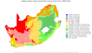
The climate of South Africa is determined by South Africa's situation between 22°S and 35°S, in the Southern Hemisphere's subtropical zone, and its location between two oceans, Atlantic and the Indian.

<span class="mw-page-title-main">Climate of the United States</span> Varies due to changes in latitude, and a range of geographic features

The climate of the United States varies due to changes in latitude, and a range of geographic features, including mountains and deserts. Generally, on the mainland, the climate of the U.S. becomes warmer the further south one travels, and drier the further west, until one reaches the West Coast.

<span class="mw-page-title-main">Climate of Ireland</span> Climate of Ireland

The climate of Ireland is mild, humid and changeable with abundant rainfall and a lack of temperature extremes. Ireland's climate is defined as a temperate oceanic climate, or Cfb on the Köppen climate classification system, a classification it shares with most of northwest Europe. The island receives generally warm summers and cool winters.

<span class="mw-page-title-main">Climate of Tasmania</span>

Tasmania has a cool temperate climate with four distinct seasons. The highest recorded maximum temperature in Tasmania is 42.2 °C (108.0 °F) at Scamander on 30 January 2009, during the 2009 southeastern Australia heat wave. Tasmania's lowest recorded minimum temperature is −14.2 °C (6.4 °F) on 7 August 2020, at Central Plateau.

<span class="mw-page-title-main">Climate of Albania</span> Overview of the climate of Albania

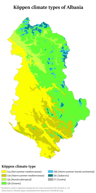
Albania has a variety of climate systems. With its coastline facing the Adriatic and Ionian seas in the Mediterranean sea, its highlands backed upon the elevated Balkan landmass, and the entire country lying at a latitude subject to a variety of weather patterns during the winter and summer seasons, however it has a high number of climatic regions for such a small area. The coastal lowlands have typically mediterranean climate while the highlands have a continental climate. In both the lowlands and the interior, the weather varies markedly from north to south.

<span class="mw-page-title-main">Climate of Hungary</span> Overview of the climate of Hungary

The climate of Hungary is characterized by its position. Hungary is in the eastern part of Central Europe, roughly equidistant from the Equator and the North Pole, more than 1,000 kilometres (600 mi) from both and about 1,000 kilometres from the Atlantic Ocean.

<span class="mw-page-title-main">Humid subtropical climate</span> Transitional climatic zone

A humid subtropical climate is a temperate climate type characterized by hot and humid summers, and cool to mild winters. These climates normally lie on the southeast side of all continents, generally between latitudes 25° and 40° and are located poleward from adjacent tropical climates, and equatorward from either humid continental or oceanic climates. It is also known as warm temperate climate in some climate classifications.

<span class="mw-page-title-main">Climate of Alabama</span> Overview of the climate of the U.S. state of Alabama

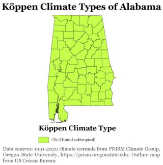
The state of Alabama is classified as humid subtropical (Cfa) under the Köppen climate classification. The state's average annual temperature is 64 °F (18 °C). Temperatures tend to be warmer in the state's southern portion with its proximity to the Gulf of Mexico, while its northern portions, especially in the Appalachian Mountains in the northeast, tend to be slightly cooler. Alabama generally has hot, humid summers and mild winters with copious precipitation throughout the year. The state receives an average of 56 inches (1,400 mm) of rainfall each year and experiences a lengthy growing season of up to 300 days in its southern portion. Hailstorms occur occasionally during the spring and summer here, but they are seldom destructive. Heavy fogs are rare, and they are confined chiefly to the coast. Thunderstorms also occur year-around. They are most common in the summer, but they are most commonly severe during the spring and late autumn. That is when destructive winds and tornadoes occur frequently, especially in the northern and central parts of the state. Central and northern Alabama are squarely within Dixie Alley, the primary area in the U.S. outside the Southern Plains with relatively high tornado risk. Alabama is ranked second in the U.S for the deadliest tornadoes. Hurricanes are quite common in the state, especially in the southern part. Major hurricanes occasionally strike the coast, such as Hurricane Frederic in September 1979 and Hurricane Ivan in September 2004; both storms resulted in significant to devastating damage in the Mobile area.

<span class="mw-page-title-main">Climate of Wales</span> Country climate

The climate of Wales refers to the weather conditions prevailing in Wales in general or over a long period.

<span class="mw-page-title-main">Climate of south-west England</span> Typical climate of South-West England

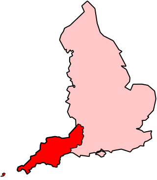
The climate of south-west England is classed as oceanic (Cfb) according to the Köppen climate classification. The oceanic climate is typified by frequent cloudy skies, cool winters with cool summers and precipitation all year round, with more experienced in winter. Annual rainfall is about 1,000 millimetres (39 in) and up to 2,000 millimetres (79 in) on higher ground. Exceptions include areas to the east of high ground ( e.g. Exeter / parts of West Somerset that are subject to a rain shadow effect and annual rainfall is closer to 30 inches.

<span class="mw-page-title-main">Climate of Cyprus</span> Climate of the Mediterranean island

Cyprus has a subtropical climate - Mediterranean and semi-arid type - Csa and BShaccording to Köppen climate classification, with very mild winters on sea level and warm to hot summers. Snow is possible only in the Troodos mountains in the central part of the island. Rain occurs mainly in winter, with summer being generally dry.

<span class="mw-page-title-main">Climate of Turkey</span> Overview of the climate of Turkey

Turkey's climate is varied and generally temperate, with the regions bordering the Mediterranean and Black Sea heavily affected by the coasts, and the interior being drier and more continental.

<span class="mw-page-title-main">Climate of Barcelona</span> Climate of Barcelona, Spain

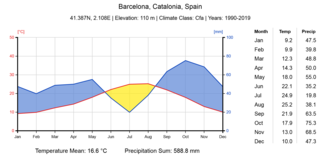
Barcelona has a Mediterranean climate (Csa) according to Köppen-Geiger classification, a warm-temperate subtropical climate according to Troll-Paffen climate classification, and a subtropical climate according to Siegmund/Frankenberg climate classification.

<span class="mw-page-title-main">Climate of France</span> Frances climate

The climate of France is the statistical distribution of conditions in the Earth's atmosphere over the national territory, based on the averages and variability of relevant quantities over a given period, the standard reference period defined by the World Meteorological Organization being 30 years. Climate characterization is based on annual and monthly statistical measurements of local atmospheric data: temperature, atmospheric pressure, precipitation, sunshine, humidity, wind speed. Recurrence and exceptional events are also taken into account.

References

  1. "World Meteorological Organization Climate Normals for 1991-2020". National Oceanic and Atmospheric Administration. Retrieved January 16, 2024.
  2. 1 2 3 4 "Climatologie globale à Istanbul / Ataturk - Infoclimat". www.infoclimat.fr. Retrieved 28 April 2021.
  3. 1 2 3 4 "Resmi İstatistikler". mgm.gov.tr. Meteoroloji Genel Müdürlüğü. Archived from the original on 23 December 2020. Retrieved 13 December 2020.
  4. Abbasnia, Mohsen; Toros, Hüseyin; Memarian, Hadi (2019). "Analysis of Climate in the Megacity of Istanbul Based on Human Bioclimatic Comfort Index". Journal of Research in Atmospheric Science. 1 (1). ISSN   0000-0000.
  5. 1 2 3 KADIOĞLU, Prof Dr Mikdat. "Lodos ve poyrazın yaptıkları". www.hurriyet.com.tr (in Turkish). Retrieved 2023-02-27.
  6. Kindap, Tayfun (2010-09-01). "A severe sea-effect snow episode over the city of Istanbul". Natural Hazards. 54 (3): 707–723. doi:10.1007/s11069-009-9496-7. ISSN   1573-0840. S2CID   140188530.
  7. Sariyuce, Isil (2021-11-30). "Extreme winds in Turkey kill 6 and injure 52". CNN. Retrieved 2023-02-27.
  8. "Türkiye Don Haritası".
  9. "Climate Explorer: Time series plots per year". climexp.knmi.nl. Retrieved 2023-03-09.
  10. "Climate Explorer: Time series plots per year". climexp.knmi.nl. Retrieved 2023-03-09.
  11. Ünal, Yurdanur S.; Sonuç, Cemre Yürük; Incecik, Selahattin; Topcu, H. Sema; Diren-Üstün, Deniz H.; Temizöz, H. Perim (2020-01-01). "Investigating urban heat island intensity in Istanbul". Theoretical and Applied Climatology. 139 (1): 175–190. doi:10.1007/s00704-019-02953-2. ISSN   1434-4483.
  12. "Türkiye Rüzgar Atlası".
  13. 1 2 "Climatologie globale à Istanbul / Ataturk - Infoclimat". www.infoclimat.fr. Retrieved 2023-10-05.
  14. "Istanbul, Turkey Marine Forecast | Current Conditions | NWS Alerts | Maps | Buoy Reports | Earth Quakes - MyForecast". www.myforecast.com. Retrieved 2023-10-05.
  15. ""İstanbul'da 150 km'lik rüzgar da görüldü"". www.trthaber.com (in Turkish). 2021-11-30. Retrieved 2023-10-05.
  16. 1 2 "Istanbul - Climate". MyForecast.
  17. "Normales et records climatologiques 2011-2020 à SARIYER - Infoclimat". www.infoclimat.fr. Retrieved 28 April 2021.
  18. "La neve sulle coste del Mediterraneo". www.nimbus.it. Retrieved 28 April 2021.
  19. 1 2 Kindap, Tayfin (19 January 2010). "A Severe Sea-Effect Snow Episode Over the City of Istanbul". Natural Hazards. 54 (3): 703–23. doi:10.1007/s11069-009-9496-7. ISSN   1573-0840. S2CID   140188530.
  20. 1 2 "Mevsim Normalleri".
  21. "Snow depth, daily, observations Istanbul from 03/02/2023, 09:00am". Meteologix - bookmark this page. Retrieved 2023-03-02.
  22. "İstanbul'da bazı ilçelerde kar kalınlığı 85 santimetreyi buldu". www.birgun.net.
  23. Arango, Tim (11 January 2017). "Snow Acts as a Magical Balm in an Anxious Turkey (Published 2017)". The New York Times . Retrieved 13 December 2020.
  24. Tayanç, Mete; Karaca, Mehmet; Dalfes, H. Nüzhet (1998). "March 1987 Cyclone (Blizzard) over the Eastern Mediterranean and Balkan Region Associated with Blocking". Monthly Weather Review. 126 (11): 3036. Bibcode:1998MWRv..126.3036T. doi: 10.1175/1520-0493(1998)126<3036:MCBOTE>2.0.CO;2 . hdl: 11424/245760 .
  25. "1987 İstanbul kışında neler yaşandı? Tarihe geçen kar fırtınasından çarpıcı fotoğraflar". www.cumhuriyet.com.tr (in Turkish). Retrieved 2023-03-02.
  26. Havadelisi (2013-12-10). "Juventus'u Kuzudişi (Graupel) Bile Kurtaramadı (O Yağış Kar Değildi)". Hava Delisinin Not Defteri (in Turkish). Retrieved 2023-03-02.
  27. Orru, Marco (2013-12-10). "Juventus-Galatasaray, non è stata neve, ma il 'Graupel'". Juvelive.it (in Italian). Retrieved 2023-03-02.
  28. "Climatologie de l'année 2018 à Kumkoy - Infoclimat". www.infoclimat.fr. Retrieved 2023-03-04.
  29. "July 1950 Historical Weather at Istanbul Atatürk Airport, Turkey - Weather Spark". weatherspark.com. Retrieved 2023-03-04.
  30. "Istanbul, Turkey Marine Forecast | Current Conditions | NWS Alerts | Maps | Buoy Reports | Earth Quakes - MyForecast". www.myforecast.com. Retrieved 2023-03-04.
  31. Zariç, Mahfuz. "Recaî-Zâde Mahmut Ekrem'in "Nefrîn" ve Tevfik Fikret'in "Sis" Adlı Şiirleri Üzerine Karşılaştırmalı Bir İnceleme". Batman Üniversitesi.
  32. "Climatologie globale à Istanbul / Ataturk - Infoclimat". www.infoclimat.fr. Retrieved 2023-03-04.
  33. Karaca, M.; Anteplioĝlu, Ü.; Karsan, H. (1995-01-01). "Detection of urban heat island in Istanbul, Turkey". Il Nuovo Cimento C. 18 (1): 49–55. doi:10.1007/BF02561458. ISSN   0390-5551. S2CID   119498339.
  34. "Climatologie globale à Golcuk / Dumlupinar - Infoclimat". www.infoclimat.fr. Retrieved 2023-03-04.
  35. 1 2 3 4 Taszarek, Mateusz; Allen, John; Púčik, Tomáš; Groenemeijer, Pieter; Czernecki, Bartosz; Kolendowicz, Leszek; Lagouvardos, Kostas; Kotroni, Vasiliki; Schulz, Wolfgang (2019-03-15). "A Climatology of Thunderstorms across Europe from a Synthesis of Multiple Data Sources". Journal of Climate. 32 (6): 1813–1837. doi: 10.1175/JCLI-D-18-0372.1 . ISSN   0894-8755. S2CID   134614362.
  36. Kahraman, Abdullah; Kadioglu, Mikdat; Markowski, Paul M. (2017-12-01). "Severe Convective Storm Environments in Turkey". Monthly Weather Review. 145 (12): 4711–4725. doi: 10.1175/MWR-D-16-0338.1 . ISSN   1520-0493. S2CID   125583875.
  37. Baltaci, Hakki; Akkoyunlu, Bulent Oktay; Tayanc, Mete (2019), Vilibić, Ivica; Horvath, Kristian; Palau, José Luis (eds.), "An Extreme Hailstorm on 27 July 2017 in Istanbul, Turkey: Synoptic Scale Circulation and Thermodynamic Evaluation", Meteorology and Climatology of the Mediterranean and Black Seas, Cham: Springer International Publishing, pp. 7–20, doi:10.1007/978-3-030-11958-4_2, ISBN   978-3-030-11958-4 , retrieved 2023-03-09
  38. SWE, Admin (2017-07-28). "Severe hailstorm, downburst and flash flooding in Istanbul, Turkey - July 27, 2017". Severe Weather Europe. Retrieved 2023-03-09.
  39. Fox, Everton. "Severe storms batter Turkey's Istanbul". www.aljazeera.com. Retrieved 2023-03-09.
  40. "Tornado, heavy summer rain hit Istanbul - Türkiye News". Hürriyet Daily News. Retrieved 2023-03-09.
  41. "Climatologie mensuelle en septembre 2022 à Istanbul / Ataturk | climatologie depuis 1900 - Infoclimat". www.infoclimat.fr. Retrieved 2023-03-09.
  42. "Climatologie mensuelle en septembre 2022 à Bursa | climatologie depuis 1900 - Infoclimat". www.infoclimat.fr. Retrieved 2023-03-09.
  43. Can, Günay; Şahin, Ümit; Sayılı, Uğurcan; Dubé, Marjolaine; Kara, Beril; Acar, Hazal Cansu; İnan, Barış; Aksu Sayman, Özden; Lebel, Germain; Bustinza, Ray; Küçükali, Hüseyin; Güven, Umur; Gosselin, Pierre (2019). "Excess Mortality in Istanbul during Extreme Heat Waves between 2013 and 2017". International Journal of Environmental Research and Public Health. 16 (22): 4348. doi: 10.3390/ijerph16224348 . ISSN   1660-4601. PMC   6887774 . PMID   31703402.
  44. 1 2 "Istanbul, Turkey – Climate data". Weather Atlas. Retrieved 29 March 2017.
  45. Peel, M.C.; Finlayson, B. L.; McMahon, T. A. (2007). "Updated world map of the Köppen-Geiger climate classification" (PDF). Hydrology and Earth System Sciences. 4 (2): 439–73. Bibcode:2007HESSD...4..439P. doi: 10.5194/hessd-4-439-2007 .
  46. Millison, Andrew (2019-08-01). "Climate Classification Systems".{{cite journal}}: Cite journal requires |journal= (help)
  47. Shimabukuro, Ryu; Tomohiko, Tomita; Fukui, Ken-ichi. "Update of global maps of Alisov's climate classification". Progress in Earth and Planetary Science. 10 (1): 1–18. doi: 10.1186/s40645-023-00547-1 .
  48. "World Strahler Climate Map".
  49. "İklim Sınıflandırmaları".
  50. "Neef Climate Map".
  51. Klimatoloji 2. Çevre ve Orman Bakanlığı.
  52. 1 2 3 4 5 6 7 8 9 Bohn, Udo; Germany. Bundesamt für Naturschutz. (2000), Karte der natürlichen Vegetation Europas: map of the natural vegetation of Europe, Bonn: Bundesamt für Naturschutz / Federal Agency for Nature Conservation, ISBN   978-3-7843-3837-8 , retrieved 2023-02-19
  53. Güngör, Tolga (2019). "Belirli iklim sınıflandırmalarının Türkiye için karşılaştırmalı analizi" (in Turkish).{{cite journal}}: Cite journal requires |journal= (help)
  54. "Comparisons of Annual Meanprecipations of Annual Meanprecipitation Gridded and Station Data: An Example from Istanbul, Turkey Yıllık Ortalama Gridlenmiş Yağış Verisi ve İstasyon Yağış Verisinin Karşılaştırılması, İstanbul Örneği – USTAOĞLU – Marmara Coğrafya Dergisi". marmara.edu.tr. Archived from the original on 4 March 2016. Retrieved 12 February 2016.
  55. "İstanbul Bölge Müdürlüğü'ne Bağlı İstasyonlarda Ölçülen Ekstrem Değerler" [Extreme Values Measured in Istanbul Regional Directorate](PDF) (in Turkish). Turkish State Meteorological Service. Archived from the original (PDF) on 24 May 2011. Retrieved 27 July 2010.
  56. 1 2 3 4 "Bitki Soğuğa ve Sıcağa Dayanıklılık". www.mgm.gov.tr. Retrieved 28 April 2021.
  57. "Bitki Soğuğa ve Sıcağa Dayanıklılık". www.mgm.gov.tr. Retrieved 28 April 2021.
  58. 1 2 S.L, Tutiempo Network. "Climate SABIHA GOKCEN - Climate data (170630)". www.tutiempo.net. Retrieved 2021-06-03.
  59. 1 2 "Normales et records climatologiques 1991-2020 à SABIHA GOKCEN - Infoclimat". www.infoclimat.fr. Retrieved 2021-06-03.
  60. "Meteoroloji Genel Müdürlüğü". www.mgm.gov.tr. Retrieved 2022-08-15.
  61. "Normales et records climatologiques 1991-2020 à Istanbul / Ataturk - Infoclimat". www.infoclimat.fr. Retrieved 2022-08-15.
  62. "Normales et records climatologiques 1981-2010 à Istanbul / Ataturk - Infoclimat". www.infoclimat.fr. Retrieved 3 June 2021.
  63. "weather istanbul - turkey - weatheronline". www.weatheronline.co.uk. Retrieved 3 June 2021.
  64. "World Meteorological Organization Climate Normals for 1991-2020". National Oceanic and Atmospheric Administration. Retrieved January 16, 2024.
  65. "Istanbul / Kurtköy - Weather History & Climate Data - Meteostat". meteostat.net. Retrieved 2021-06-03.
  66. "Pendik - Weather History & Climate Data - Meteostat". meteostat.net. Retrieved 2021-06-03.
  67. S.L, Tutiempo Network. "Climate SABIHA GOKCEN - Climate data (170630)". www.tutiempo.net. Retrieved 2021-06-03.
  68. "Normales et records climatologiques 1991-2020 à SABIHA GOKCEN - Infoclimat". www.infoclimat.fr. Retrieved 2021-06-03.
  69. Ustaoğlu, Beyza (2013-10-02). "Yıllık Ortalama Gridlenmiş Yağış Verisi ve İstasyon Yağış Verisinin Karşılaştırılması, İstanbul Örneği". Marmara Coğrafya Dergisi (in Turkish) (26): 71–81. ISSN   1303-2429.
  70. "Rivista Ligure di Meteorologia 44 - La neve sulle coste del Mediterraneo". www.nimbus.it. Retrieved 3 June 2021.
  71. "World Meteorological Organization Climate Normals for 1991-2020". National Oceanic and Atmospheric Administration. Retrieved January 16, 2024.
  72. "Üsküdar - Weather History & Climate Data - Meteostat". meteostat.net. Retrieved 2021-06-03.
  73. Toros, Hüseyin; Abbasnia, Mohsen; Sagdic, Mustafa; Tayanç, Mete (2017-11-19). "Long-Term Variations of Temperature and Precipitation in the Megacity of Istanbul for the Development of Adaptation Strategies to Climate Change". Advances in Meteorology. Retrieved 2021-06-03.
  74. "Normales et records climatologiques 2011-2020 à Kumkoy - Infoclimat". www.infoclimat.fr. Retrieved 2024-02-02.
  75. "Bahçeköy 1990-1999 Normals" (PDF). www.ibb.gov.tr.
  76. "Climate Explorer: Time series". climexp.knmi.nl. Retrieved 3 June 2021.
  77. "Climate Explorer: Time series". climexp.knmi.nl. Retrieved 2021-06-04.
  78. S.L, Tutiempo Network. "Climate SILETURKEY - Climate data (170200)". www.tutiempo.net. Retrieved 2021-06-04.
  79. "World Meteorological Organization Climate Normals for 1991-2020". National Oceanic and Atmospheric Administration. Retrieved January 16, 2024.