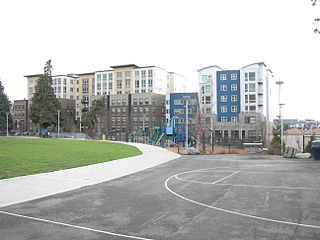
Cascade is an urban neighborhood abutting Downtown Seattle, Washington, United States, located adjacent to South Lake Union. It is bounded by: Fairview Avenue North on the west, beyond which is the rest of the Cascade Neighborhood; the Interstate 5 interchange for Mercer St to the north, beyond which is Eastlake; Interstate 5 on the east, beyond which is Capitol Hill; and Denny Way on the south, beyond which is Denny Triangle. It is surrounded by thoroughfares Mercer Street (eastbound), Fairview Avenue N. and Eastlake Avenue E., and Denny Way. The neighborhood, one of Seattle's oldest, originally extended much further: west to Terry Avenue, south to Denny Hill on the South, and east to Melrose Avenue E through the area now obliterated by Interstate 5. Some recent writers consider Cascade to omit the northern "arm", while others extend it westward to cover most of South Lake Union.
Midtown is a collection of neighborhoods in Memphis, Tennessee, to the east of Downtown.

Huntingdon College is a private Methodist college in Montgomery, Alabama. It was founded in 1854 as a women's college.

Washington Park is a neighborhood and public urban park in Denver, Colorado. The Washington Park is a blend of historic and contemporary styles of architecture. The park was first developed by Architect Reinhard Schuetze in 1899. Its design was influenced by city planner Kessler, the Olmsted Brothers and philanthropist Margaret "Molly" Brown. The park is popular with both tourists and area residents, with some comparing it to New York City's Central Park. Apart from activities such as walking, biking or volleyball, the park serves as a center for community gatherings, such as the annual Furry Scurry. Wedding receptions are often held in the historic boathouse pavilion. In 2012 the American Planning Association designated the park one of its “Great Public Spaces in America”.
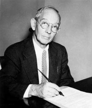
Frederick Law Olmsted Jr. was an American landscape architect and city planner known for his wildlife conservation efforts. He had a lifetime commitment to national parks, and worked on projects in Acadia, the Everglades and Yosemite National Park. He gained national recognition by filling in for his father on the Park Improvement Commission for the District of Columbia beginning in 1901, and by contributing to the famous McMillan Commission Plan for redesigning Washington according to a revised version of the original L’Enfant plan. Olmsted Point in Yosemite and Olmsted Island at Great Falls of the Potomac River in Maryland are named after him.

Neighborhoods in Spokane, Washington are officially grouped by the Spokane City Council into three main city council districts: 1, 2, and 3. Each city council district contains multiple, official neighborhoods that are recognized with a neighborhood council. Informally, neighborhoods are colloquially grouped by local geographical, geological, cultural, or historical features The list of neighborhoods below is organized based on the official designations by the City of Spokane. Unofficial neighborhoods and districts are listed within the official neighborhood in which they are located.

City Park is an urban park and neighborhood in Denver, Colorado. The park is 330 acres (1.3 km2) and is located in east-central Denver. The park contains the Denver Zoo, the Denver Museum of Nature and Science, Ferril and Duck Lakes, and a boathouse. City Park is also the name of the neighborhood that contains the park, though the park is the vast majority of the neighborhood. To the immediate north of the park is the City Park Golf Course. City Park is the largest park in Denver.

South Park is a 24-block, 150-acre area of more than 780 structures primarily dating from the 1880s to the early twentieth century. It is located south of downtown Dayton, Ohio, just north of the University of Dayton campus and Woodland Cemetery, and east of Miami Valley Hospital. Mainly residential in character, South Park is significant because of the variety of its architecture, which includes vernacular, cottage, and high style examples, and because of its association with John H. Patterson, founder of the National Cash Register Company.

Fenway, commonly referred to as The Fenway, is a mostly one-way, one- to three-lane parkway that runs along the southern and eastern edges of the Back Bay Fens in the Fenway–Kenmore neighborhood of Boston, in the east-central part of the U.S. state of Massachusetts. As part of the Emerald Necklace park system mainly designed by Frederick Law Olmsted in the late 19th century, the Fenway, along with the Back Bay Fens and Park Drive, connects the Commonwealth Avenue Mall to the Riverway. For its entire length, the parkway travels along the Muddy River and is part of the Metropolitan Park System of Greater Boston. Like others in the park system, it is maintained by the Massachusetts Department of Conservation and Recreation.
Sedgwick is one of the 26 officially recognized neighborhoods of Syracuse, New York, United States. It borders four other Syracuse neighborhoods, with Northside to the north and west, Near Northeast to the southwest, Lincoln Park to the south, and Eastwood to the east.

Blue Hills Parkway is a historic parkway that runs in a straight line from a crossing of the Neponset River, at the south border of Boston to the north edge of the Blue Hills Reservation in Milton, Massachusetts. It was built in 1893 to a design by the noted landscape architect, Charles Eliot, who is perhaps best known for the esplanades along the Charles River. The parkway is a connecting road between the Blue Hills Reservation and the Neponset River Reservation, and was listed on the National Register of Historic Places in 2003.
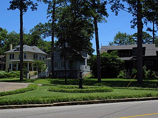
The Cloverdale Historic District is a 156-acre (63 ha) historic district in Montgomery, Alabama. It is roughly bounded by Norman Bridge and Cloverdale roads, Fairview and Felder avenues, and Boultier Street. It contains 463 contributing buildings and 4 structures that date from the mid-19th to the early 20th centuries. The district was placed on the National Register of Historic Places on September 12, 1985.

The Garden District is a 315-acre (127 ha) historic district in Montgomery, Alabama.
Cloverdale-Idlewild is a neighborhood in Montgomery, Alabama. It is circumscribed by Edgemont Street, Norman Bridge Road, Fairview Avenue, and Audubon Road.

Frank Lockwood (1865-1935) was one of Montgomery, Alabama's leading architects.

Lewis Fulton Memorial Park is a public park in the city of Waterbury, Connecticut. Located north of the city center, it was developed in the 1920s through the philanthropy of William Fulton, a brass company owner, as a memorial to his son Lewis. Its grounds were designed by the Olmsted Brothers landscape architects, and were largely completed by 1925. The park includes facilities for both active and passive recreation, and retains many Olmsted-designed features. It was listed on the National Register of Historic Places in 1990.

Rockwood is a neighborhood in Spokane, Washington. It is located on the south side of the city to the southeast of Downtown Spokane and expanding southeasterly from close to the city center. Its proximity to downtown makes it one of Spokane's older neighborhoods, with mature trees lining most of its streets. Due to its location on the hill leading up from the Spokane River Valley, the street grid breaks down in many places around Rockwood. The most notable of these is along the winding Rockwood Boulevard, which was designed by the Olmsted Brothers and weaves its way from the northwesternmost corner of the neighborhood through the center and across to the eastern border, highlighting the basalt bluffs and other natural topography.

Spokane and its neighborhoods contain a patchwork of architectural styles that give them a distinct identity and illustrate the changes throughout the city's history. Spokane has a rich architectural history for a western city of its size and much of it is a product of its circumstances at the turn of the 20th century when as a rapidly growing city, the Great Fire of 1889 destroyed 32 blocks of the city center which was quickly rebuilt in a more grand fashion by a community flush with money coming from regional mining districts. Many of the architects that found work in the city and building on the blank slate of the downtown commercial district became highly esteemed architects such as Kirtland Cutter, who has been credited with giving the city a distinctive character. In particular, the city has a high concentration of Romanesque Revival style institutional and commercial buildings and American Craftsman bungalow residences. The architecture of Spokane gained national recognition in industry publications in the early 20th century.