Coatham

Last updated

Coatham
Redcar Cricket Club - geograph.org.uk - 3245223.jpg
Redcar Cricket Ground with Trafalgar Terrace and Coatham Road in the background
North Yorkshire UK location map (2023).svg
Red pog.svg
Coatham
Location within North Yorkshire
Population5,326 (2011 census) [1]
OS grid reference NZ592250
Unitary authority
Ceremonial county
Region
Country England
Sovereign state United Kingdom
Post town REDCAR
Postcode district TS10
Police Cleveland
Fire Cleveland
Ambulance North East
List of places
UK
England
Yorkshire
54°37′01″N1°05′04″W / 54.61686°N 1.08448°W / 54.61686; -1.08448

Coatham is an area of Redcar, in the borough of Redcar and Cleveland and the ceremonial county of North Yorkshire, England.

Contents

History

There is reputed to be an entry in Domesday Book – the first recorded reference to Coatham as "there is a Hamlet of Cotes (one-roomed cottages or shacks) on the beach where the people collect coal from boats from Hartlepool, to carry by pack animal to the Abbey at Guisborough for the heating for the monks there". Probably the people of the Hamlet of Cotes were taxed accordingly, and the place became known as "cote-ham" or similar? Coatham can be traced back to the 12th century, when "Roger son of William de Tocketts gave a salt-pan in 'Cotum' to Guisborough Priory." [2] There was a significant port there, owned by the de Brus family in the 13th century. [2] The weekly market of Kirkleatham parish was held in Coatham (possibly because of the presence of the port) and there was a three-day fair. [2] These were chartered in 1257 by King Henry III. [3]

Christ Church, parish church of Coatham and Dormanstown Christ Church - geograph.org.uk - 6071550.jpg
Christ Church, parish church of Coatham and Dormanstown

Though Coatham is now only a one-mile-wide (1.5-kilometre) district in the town of Redcar, the need for definition was strong enough to warrant the western boundary being marked by a fence which ran the length of West Dyke Road and West Terrace. Coatham comprises the remaining coastal land north of the railway line from West Dyke Road to Warrenby in the west. The present-day Redcar & Cleveland College was a grammar school before 1975 named Sir William Turner's.

Coatham was formerly a chapelry in the parish of Kirk-Leatham, [4] on 1 April 1899 Coatham became a separate civil parish, on 1 April 1921 the parish was abolished and merged with Redcar. [5] In 1911 the parish had a population of 4744. [6] Until 1974 it was in the North Riding of Yorkshire. From 1974 to 1996 it was in the county of Cleveland.

Coatham Pier

Between 1875 and 1898, Coatham had a leisure pier. It was intended to extend 2,000 feet (600 metres) into the sea, but damage in the building stage from shipping and storms curtailed the distance to 1,800 ft (550 m). [7] In October 1898, the pier was struck by the 757-tonne (834-short-ton) Finnish freighter Birger. The ship had developed trouble during a storm in the North Sea and despite passing Grimsby, Scarborough and Whitby, she carried on for South Shields. During a ferocious storm she crashed onto the rocks at Coatham and wrecked a 60-foot (18-metre) section of the pier in the middle. Only two members of her crew of 15 were rescued; the pier collapsed a year later. [8]

Landmarks

The majority of modern Coatham is Victorian housing, most notably at its northern tip by the Coatham Hotel built in 1860. A small boating lake, leisure centre, arcade complex and caravan park now occupies the remainder of Coatham's coast. To the east, the Tees Valley Wildlife Trust's Coatham Marsh Nature Reserve hosts 54 hectares (130 acres) of ancient Marsh and grassland. [9]

Future development

Since the mid-1990s political debate has been generated amongst Coatham's five thousand residents as to the future of the last undeveloped section of Coatham's coastal land known as Coatham Common/Coatham Enclosure - for the last 25 years used as a golf course and local recreation area. Residents are objecting at losing open space to the council's proposed housing and leisure development planned to revive the tourist industry. The Supreme Court of the United Kingdom announced on 3 March 2010 that Redcar Council must register the land as a Village Green. [10]

Notable residents

Coatham is the town where Jane Gardam, twice winner of the Whitbread Prize, was brought up and where some of her novels are set. [11]

Related Research Articles

<span class="mw-page-title-main">Guisborough</span> Market town in North Yorkshire, England

Guisborough is a market town and civil parish in the borough of Redcar and Cleveland, North Yorkshire, England. It lies north of the North York Moors National Park. Roseberry Topping, midway between the town and Great Ayton, is a landmark in the national park. At the 2011 census, the civil parish with outlying Upleatham, Dunsdale and Newton under Roseberry had a population of 17,777, of which 16,979 were in the town's built-up area. It was governed by an urban district and rural district in the North Riding of Yorkshire.

<span class="mw-page-title-main">North Riding of Yorkshire</span> Third of a historic county in England

The North Riding of Yorkshire was a subdivision of Yorkshire, England, alongside York, the East Riding and West Riding. The riding's highest point was at Mickle Fell at 2,585 ft (788 m).

<span class="mw-page-title-main">Redcar and Cleveland</span> Borough in North Yorkshire, England

Redcar and Cleveland is a unitary authority area with borough status in North Yorkshire, England.

<span class="mw-page-title-main">Redcar</span> Town in North Yorkshire, England

Redcar is a seaside town on the Yorkshire Coast in the Redcar and Cleveland unitary authority in the ceremonial county of North Yorkshire, England. It is located 7 miles (11 km) east of Middlesbrough.

<span class="mw-page-title-main">Tees Valley</span> Combined authority area in Northern England

Tees Valley is a combined authority area in Northern England, around the lower River Tees. The area is not a geographical valley; the local term for the valley is Teesdale. The combined authority covers five council areas: Darlington, Hartlepool, Middlesbrough, Redcar and Cleveland and Stockton-on-Tees.

<span class="mw-page-title-main">Loftus, North Yorkshire</span> Town and civil parish in North Yorkshire, England

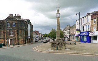
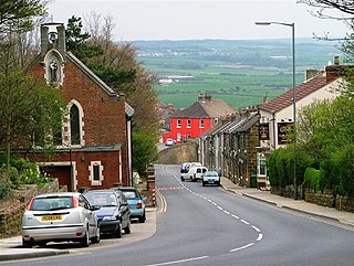
Loftus is a market town and civil parish in the Redcar and Cleveland borough of North Yorkshire, England. The town is located north of the North York Moors and sits between Whitby and Skelton-in-Cleveland.

<span class="mw-page-title-main">Redcar (UK Parliament constituency)</span> Parliamentary constituency in the United Kingdom, 1974 onwards

Redcar is a constituency represented in the House of Commons of the UK Parliament since 2019 by Jacob Young, a Conservative.

<span class="mw-page-title-main">Normanby, Redcar and Cleveland</span> Area of Redcar and Cleveland, North Yorkshire, England

Normanby is an area in the borough of Redcar and Cleveland, North Yorkshire, England. A ward covering the area had a population of 6,930 at the 2011 census. It is part of Greater Eston, which includes the area and the outlying settlements of Eston, Grangetown, South Bank, Teesville and part of Ormesby.

<span class="mw-page-title-main">Ormesby</span> Area of Middlesbrough, North Yorkshire, England

Ormesby a village in North Yorkshire, England. Its governance is split between two unitary authorities, to the north Middlesbrough and to the south Redcar and Cleveland, both are part of the devolved Tees Valley area. It is in the Middlesbrough part of the Teesside built up area.

<span class="mw-page-title-main">Brotton</span> Village in North Yorkshire, England

Brotton is a village in the civil parish of Skelton and Brotton, in the Redcar and Cleveland district, in the ceremonial county of North Yorkshire, England It is situated approximately 2.5 miles (4 km) south-east of Saltburn-by-the-Sea, 9 miles from Redcar, 12 miles (19 km) east of Middlesbrough and 14 miles (23 km) north-west of Whitby.

<span class="mw-page-title-main">Saltburn, Marske and New Marske</span> Civil parish in North Yorkshire, England

Saltburn, Marske and New Marske is a civil parish in the Redcar and Cleveland district, in the ceremonial county of North Yorkshire, England. According to the 2001 census it had a population of 18,325 increasing to 19,134 at the 2011 census. As its name suggests, the parish includes Saltburn, Marske-by-the-Sea and New Marske. It borders the parishes of Skelton and Brotton, Guisborough and the unparished area of Redcar.

<span class="mw-page-title-main">Langbaurgh Wapentake</span> Former administrative division of Yorkshire, England

Langbaurgh was a liberty or wapentake of the North Riding of Yorkshire. It covered an area of the shire's north-eastern tip. The wapentake took its name from Langbaurgh hamlet, in present-day Great Ayton parish.

<span class="mw-page-title-main">Easington, North Yorkshire</span> Village in North Yorkshire, England

Easington is a village in the civil parish of Loftus, in the Redcar and Cleveland district, in the ceremonial county of North Yorkshire, England and is part of the North York Moors National Park. The village is situated on the A174 road, 1 mile (1.6 km) east of Loftus, 8 miles (13 km) east of Guisborough, and 10 miles (16 km) north-west of Whitby. At the 2011 census, the village had a population of 923.

<span class="mw-page-title-main">Kilton, North Yorkshire</span> Village in the Borough of Redcar and Cleveland, England

Kilton is a village in the civil parish of Lockwood, in the borough of Redcar and Cleveland, in the ceremonial county of North Yorkshire, England.

<span class="mw-page-title-main">Kirkleatham</span> Area of Redcar in North Yorkshire, England

Kirkleatham is an area of Redcar in the borough of Redcar and Cleveland in North Yorkshire, England. It is approximately 4+12 miles north-northwest of Guisborough, and three miles south of Redcar centre. It was listed in the Domesday Book.

<span class="mw-page-title-main">Upleatham</span> Village in North Yorkshire, England

Upleatham is a village in the civil parish of Guisborough, in the unitary authority area of Redcar and Cleveland and the ceremonial county of North Yorkshire, England. The village was mentioned in the Domesday Book and the name derives from Old English and Old Norse as Upper Slope, in that it was further up the hill than Kirkleatham.

<span class="mw-page-title-main">Redcar & Cleveland College</span> Fe college in Redcar, North Yorkshire, England

Redcar and Cleveland College is a further education college, based in Redcar, North Yorkshire, England. The college offers apprenticeship training as well as A-level, vocational and higher education courses.

<span class="mw-page-title-main">Guisborough Town Hall</span> Municipal building in Guisborough, North Yorkshire, England

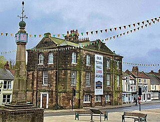
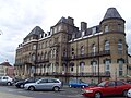
Guisborough Town Hall is a municipal building on Westgate in Guisborough, North Yorkshire, England. The structure, which has mainly been used as a venue for magistrates' court hearings, is a Grade II listed building.

<span class="mw-page-title-main">Coatham Marsh</span> Nature reserve in Northern England

Coatham Marsh is a 54-hectare (130-acre) nature reserve near to Redcar in the borough of Redcar and Cleveland, England. The site is a local nature reserve and part of the Teesmouth and Cleveland Coast SSSI.

References

  1. UK Census (2011). "Local Area Report – Coatham Ward (as of 2011) (1237321162)". Nomis. Office for National Statistics . Retrieved 21 October 2018.
  2. 1 2 3 "A History of the County of York North Riding: Volume 2. Originally published by Victoria County History, London, 1923". British History Online. Retrieved 17 May 2020.
  3. Letters, Samantha (ed.). "Gazetteer of markets and fairs in England and Wales to 1516". Centre for Metropolitan history. Retrieved 18 May 2020.
  4. "History of Coatham, in Redcar and Cleveland and North Riding". A Vision of Britain through Time . Retrieved 5 May 2024.
  5. "Relationships and changes Coatham CP through time". A Vision of Britain through Time. Retrieved 5 May 2024.
  6. "Population statistics Coatham CP through time". A Vision of Britain through Time. Retrieved 5 May 2024.
  7. Historic England. "Coatham Pier (1463355)". Research records (formerly PastScape). Retrieved 21 October 2018.
  8. Lloyd, Chris (19 October 2018). "End of the pier story". Darlington & Stockton Times. No. 42–2016. p. 37. ISSN   2516-5348.
  9. "Coatham Marsh - Tees Valley Wildlife Trust". Tees Valley Wildlife Trust. Retrieved 21 October 2018.
  10. Gray, Louise (4 March 2010). "High Court rules ramblers have right of way". The Telegraph. Retrieved 2 August 2016.
  11. Stade, George; Karbiener, Karen (2009). Encyclopedia of British writers, 1800 to the present (2 ed.). New York: Facts On File. p.  199. ISBN   978-0-8160-7385-6.