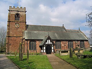
Tattenhall is a village and former civil parish, now in the parish of Tattenhall and District, 8 miles (13 km) south-east of Chester, in the unitary authority area of Cheshire West and Chester and the ceremonial county of Cheshire, England. In the 2001 census, the population was recorded as 1,986, increasing to 2,079 by the 2011 census.
Hemingstone is a village and civil parish in the Mid Suffolk district of Suffolk in eastern England located 6.5 miles (11 km) north of Ipswich.

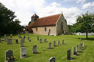
Mendlesham is a village in Suffolk with 1,407 inhabitants at the 2011 census. It lies 5 miles (8 km) north east of Stowmarket and 73.135 miles (117.699 km) from London.

Culford is a village and civil parish about 4 miles (6 km) north of Bury St Edmunds and 62 miles (100 km) north east of London in the West Suffolk district of Suffolk, England.
Barnby is a village and civil parish in the East Suffolk district of the English county of Suffolk. The village is 5 miles (8.0 km) west of Lowestoft and 3 miles (4.8 km) east of Beccles in the north of the county. It is effectively merged with the village of North Cove which constitutes a separate parish.

Witton is a village and civil parish in the English county of Norfolk. It is located 8 km (5.0 mi) east of the town of North Walsham and 30 km (19 mi) north of the city of Norwich. It should not be confused with the quite different Norfolk village of similar name in the parish of Postwick with Witton, some 8 km (5.0 mi) east of Norwich.

Long Stratton is a town and civil parish in Norfolk, England. It historically consisted of two villages; the larger, Stratton St. Mary, is to the south, and the other, Stratton St. Michael, is to the north. It had a population of 4,424 in the 2011 Census. South Norfolk Council are based in the town.

Stanton is a village and civil parish in the West Suffolk district of Suffolk in eastern England, about nine miles north-east of Bury St Edmunds, on the A143 road to Diss. Close to the village lies the former WW II airfield RAF Shepherds Grove, where American forces were based. One of the main landmarks in the village is the fine restored windmill at Upthorpe Farm, to the east of the village. The name " Stanton" means 'a homestead on stony ground'.

Crowfield is a village in Suffolk, England. It is in Helmingham and Coddenham ward in the Mid Suffolk local authority, in the East of England region.

Stanstead is a village and civil parish in Suffolk, England. The name Stanstead comes from the Old English for "Stony place". Located off the B1066, it is around 4 miles (6 km) from Sudbury, and is part of Babergh district. It is about 2 kilometres (1 mi) from Glemsford, 12 miles (19 km) from Hadleigh, and 4 miles (6 km) from Lavenham.

Pettaugh is a village and civil parish located within the district council area of Mid Suffolk, England.

Ixworth is a village and civil parish in the West Suffolk district of Suffolk, England, 6 miles (9.7 km) north-east of Bury St Edmunds on the A143 road to Diss and 9 miles (14 km) south-east of Thetford. The parish had a population of 2,365 at the 2011 Census.

Elmswell is a village and civil parish in the county of Suffolk, England. It is situated halfway between Bury St. Edmunds and Stowmarket and lies just to the north of the A14 road.

Creeting St Mary is a village and civil parish in the Mid Suffolk district of Suffolk in eastern England. Sandwiched between the A14 and A140 to the north of Needham Market, the parish also includes the hamlet of Creeting Bottoms. In 2005 the parish population was 710, which decreased to 697 at the 2011 Census.

Hinderclay is a village and civil parish in the Mid Suffolk district of Suffolk in eastern England. The village is located around 14 miles (23 km) - from Bury St Edmunds in an area of rolling arable land to the south of the Little Ouse river valley. Neighbouring villages include Thelnetham and Rickinghall. In 2005 its population was 340. The parish also contains the hamlet of Thorpe Street.

Great Whelnetham is a village and civil parish in the West Suffolk district of Suffolk in eastern England. Located around two miles south of Bury St Edmunds, in 2005 its population was 820.
Wixoe is a village and civil parish in the West Suffolk district of Suffolk in eastern England. Located on the northern bank of the River Stour, two miles south-east of Haverhill, in 2005 its population was 140. It consists largely of Victorian cottages along a narrow lane. There is a church of 12th-century origin, St Leonard's, much restored in the 1880s. It was recorded in the Domesday Book, at 600 acres one of the smallest parishes in the hundred of Risbridge. There are some 13 listed buildings, including a 19th-century bridge and a water mill.

Wickhambrook is a village and civil parish in the West Suffolk district of Suffolk in eastern England. It is about ten miles (16 km) south-west from Bury St Edmunds, halfway to Haverhill, off the A143 road. Wickhambrook is the largest village by area in the county of Suffolk with a population of 1170 in 2005.

Lackford is a village and civil parish in the West Suffolk district of Suffolk in eastern England. Located around four miles north-west of Bury St Edmunds on the A1101, in 2005 it had a population of 270.

Flixton is a civil parish in the north of the English county of Suffolk. It is 2 miles (3.2 km) north-east of Lowestoft in the East Suffolk district.