Radley is a village and civil parish about 2 miles (3 km) northeast of the centre of Abingdon, Oxfordshire. The parish includes the hamlet of Lower Radley on the River Thames. It was part of Berkshire until the 1974 boundary changes transferred it to Oxfordshire. The village is home to Radley College, a famous boarding independent school for boys from the age of thirteen to eighteen that consists of 690 pupils.
Uffington is a village and civil parish in Oxfordshire, about 4 miles (6.4 km) south of Faringdon and 6 miles (10 km) west of Wantage. The 2011 Census recorded the parish's population as 783. Lying within the historic county boundaries of Berkshire, in 1974 it was transferred for local government purposes to Oxfordshire under the Local Government Act 1972. Uffington is most commonly known for the Uffington White Horse hill figure on the Berkshire Downs in the south of the parish.

Farnborough is a village and civil parish in West Berkshire, about 4 miles (6.4 km) south of Wantage. The village is 720 feet (220 m) above sea level on a ridge aligned east – west in the Berkshire Downs. It is the highest village in Berkshire.
Ashbury is a village and large civil parish at the upper end (west) of the Vale of White Horse. It was part of Berkshire until the 1974 boundary changes transferred it to Oxfordshire. The village is centred 7 miles (11 km) east of Swindon in neighbouring Wiltshire. The parish includes the hamlets of Idstone and Kingstone Winslow. The 2011 Census recorded the parish's population as 506.

Aston Tirrold is a village and civil parish at the foot of the Berkshire Downs about 3 miles (5 km) southeast of Didcot. It was part of Berkshire until the 1974 boundary changes transferred it to Oxfordshire. The 2011 Census recorded the parish's population as 373.

Buckland is a village and large civil parish about 4 miles (6.4 km) northeast of Faringdon in the Vale of White Horse District. Buckland was part of Berkshire until the 1974 boundary changes transferred it to Oxfordshire. The 2011 Census recorded the parish's population as 588. Outside the village the civil parish includes the small settlements of Carswell and Barcote to the west, Buckland Marsh to the north, and the modern development of Gainfield on the southern boundary.

Drayton is a village and civil parish about 2 miles (3 km) south of Abingdon, Oxfordshire. It was part of Berkshire until the 1974 boundary changes transferred it to Oxfordshire. The parish includes the hamlet of Sutton Wick. The 2011 Census recorded the parish population as 2,353.

Sunningwell is a village and civil parish about 3+1⁄2 miles (6 km) south of Oxford, England. The parish includes the village of Bayworth and the eastern part of Boars Hill. The parish was part of Berkshire until the 1974 boundary changes transferred it to Oxfordshire. The 2011 Census recorded the parish population as 904.
Mollington is a village and civil parish about 4 miles (6.4 km) north of Banbury in Oxfordshire, England. The 2011 Census recorded the parish's population as 479.

Childrey is a village and civil parish about 2+1⁄2 miles (4 km) west of Wantage in the Vale of White Horse. The parish was part of the Wantage Rural District in Berkshire until the 1974 boundary changes transferred the Vale of White Horse to Oxfordshire. The 2021 Census recorded the parish population as 527.

Appleton is a village in the civil parish of Appleton-with-Eaton, about 4 miles (6.4 km) northwest of Abingdon. Appleton was part of Berkshire until the 1974 boundary changes transferred it to Oxfordshire. The 2011 Census recorded Appleton-with-Eaton's parish population as 915.
Buscot is an English village and civil parish on the River Thames, about 1.5 miles (2.4 km) south-east of Lechlade. Buscot was part of Berkshire until the 1974 boundary changes transferred it to Oxfordshire. Two houses there contain notable collections of paintings.

Milton is a village and civil parish about 3 miles (5 km) west of Didcot and a similar distance south of Abingdon. The 2011 Census recorded the parish's population as 1,290.

Brightwell Baldwin is a village and civil parish in Oxfordshire, about 4+1⁄2 miles (7 km) northeast of Wallingford. It was historically in the Hundred of Ewelme and is now in the District of South Oxfordshire. The 2011 Census recorded the parish's population as 208. The parish is roughly rectangular, about 2+1⁄2 miles (4 km) long north–south and about 1+1⁄4 miles (2 km) wide east–west. In 1848 the parish covered an area of 1,569 acres (635 ha). The B4009 road linking Benson and Watlington forms part of the southern boundary of the parish. The B480 road linking Oxford and Watlington forms a small part of its northern boundary. Rumbolds Lane forms much of its western boundary. For the remainder the parish is bounded largely by field boundaries.

West Hanney is a village and civil parish about 3 miles (5 km) north of Wantage, Oxfordshire, England. Historically West and East Hanney were formerly a single ecclesiastical parish of Hanney. East Hanney was part of Berkshire until the 1974 boundary changes transferred the Vale of White Horse to Oxfordshire. The 2011 Census recorded the parish's population as 490.

Great Coxwell is a village and civil parish 2 miles (3 km) southwest of Faringdon in the Vale of White Horse, England. It was in Berkshire until the 1974 boundary changes transferred it to Oxfordshire. The 2021 Census recorded the parish's population as 295 in 124 households.

Shellingford, historically also spelt Shillingford, is a village and civil parish about 2+1⁄2 miles (4 km) south-east of Faringdon in the Vale of White Horse in Oxfordshire, England. It was part of Berkshire until the 1974 Local Government Act transferred it to Oxfordshire. The 2011 Census recorded the parish's population as 173.

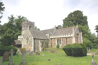
Hinton Waldrist is a village and civil parish in the Vale of White Horse, England. It was part of Berkshire until the 1974 boundary changes transferred it to Oxfordshire. The village is between Oxford and Faringdon, 9 miles (14 km) southwest of Oxford. The parish includes the hamlet of Duxford. The 2011 Census recorded the parish's population as 328.
Sparsholt is a village and civil parish about 3 miles (5 km) west of Wantage in the Vale of White Horse district of Oxfordshire. The parish includes the hamlet of Westcot about 1⁄2 mile (800 m) west of the village. Sparsholt was part of Berkshire until the 1974 boundary changes transferred the Vale of White Horse to Oxfordshire.
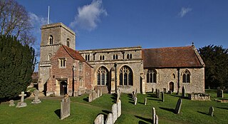
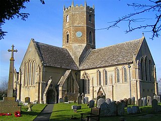
The Church of All Saints, Sutton Courtenay is the Church of England parish church of Sutton Courtenay, England. Extant since at least the 12th century, the church has been Grade I listed since 1966. It is in the centre of the village, near the northeast corner of the village green.


