Collings Lakes, New Jersey

Last updated

Collings Lakes, New Jersey
Atlantic County New Jersey Incorporated and Unincorporated areas Collings Lakes Highlighted.svg
Map of Collings Lakes CDP in Atlantic County. Inset: Location of Atlantic County in New Jersey.
Location map of Atlantic County, New Jersey.svg
Red pog.svg
Collings Lakes
Location in Atlantic County
USA New Jersey relief location map.svg
Red pog.svg
Collings Lakes
Location in New Jersey
Usa edcp relief location map.png
Red pog.svg
Collings Lakes
Location in the United States
Coordinates: 39°35′41″N74°53′19″W / 39.594668°N 74.888626°W / 39.594668; -74.888626 [1] [2]
Country Flag of the United States.svg  United States
State Flag of New Jersey.svg  New Jersey
County Atlantic
Township Buena Vista
Area
[3]
  Total0.70 sq mi (1.82 km2)
  Land0.64 sq mi (1.66 km2)
  Water0.06 sq mi (0.16 km2)  8.88%
Elevation
[4]
79 ft (24 m)
Population
 (2020) [5]
  Total1,501
  Density2,338.01/sq mi (903.29/km2)
Time zone UTC−05:00 (Eastern (EST))
  Summer (DST) UTC−04:00 (EDT)
ZIP Code
08094 [6]
Area code 609
FIPS code 3414230 [1] [7] [8]
GNIS feature ID02389344 [1] [9]
Website www.collingslakes.org

Collings Lakes is an unincorporated community and census-designated place (CDP) located within Buena Vista Township in Atlantic County, in the U.S. state of New Jersey. [10] [11] [12] As of the 2010 United States Census, the CDP's population was 1,706. [13]

Contents

Collings Lakes is not an incorporated municipality, though homes in the neighborhood are subject to certain deed restrictions and to the Collings Lakes Civic Association. Homeowners are not required to become members of the Civic Association, nor are they required to comply with CLCA bylaws. Homeowners are required to pay an annual fee of $48.00 for "maintenance of lakes and beaches". Membership in the CLCA is voluntary per New Jersey Superior Court ruling on September 15, 2006. [14]

Geography

According to the United States Census Bureau, the CDP had a total area of 0.701 square miles (1.816 km2), including 0.639 square miles (1.655 km2) of land and 0.062 square miles (0.161 km2) of water (8.88%). [1] [2]

Demographics

Historical population
CensusPop.Note
1990 2,046
2000 1,726−15.6%
2010 1,706−1.2%
2020 1,501−12.0%
Population sources:
1990-2010 [12] 2000 [15] 2010 [13] [5]

2010 census

The 2010 United States census counted 1,706 people, 575 households, and 442 families in the CDP. The population density was 2,669.9 per square mile (1,030.9/km2). There were 605 housing units at an average density of 946.8 per square mile (365.6/km2). The racial makeup was 86.23% (1,471) White, 5.98% (102) Black or African American, 0.53% (9) Native American, 0.59% (10) Asian, 0.12% (2) Pacific Islander, 3.11% (53) from other races, and 3.46% (59) from two or more races. Hispanic or Latino of any race were 11.31% (193) of the population. [13]

Of the 575 households, 33.2% had children under the age of 18; 58.4% were married couples living together; 14.1% had a female householder with no husband present and 23.1% were non-families. Of all households, 17.7% were made up of individuals and 4.3% had someone living alone who was 65 years of age or older. The average household size was 2.97 and the average family size was 3.38. [13]

25.3% of the population were under the age of 18, 9.4% from 18 to 24, 25.5% from 25 to 44, 29.2% from 45 to 64, and 10.6% who were 65 years of age or older. The median age was 38.3 years. For every 100 females, the population had 97.2 males. For every 100 females ages 18 and older there were 92.0 males. [13]

2000 census

As of the 2000 United States Census [7] there were 1,726 people, 564 households, and 463 families residing in the CDP. The population density was 994.6/km2 (2,574.5/mi2). There were 596 housing units at an average density of 343.5/km2 (889.0/mi2). The racial makeup of the CDP was 88.76% White, 4.11% African American, 0.29% Native American, 0.29% Asian, 4.58% from other races, and 1.97% from two or more races. Hispanic or Latino of any race were 8.52% of the population. [15]

There were 564 households, out of which 39.7% had children under the age of 18 living with them, 61.7% were married couples living together, 13.8% had a female householder with no husband present, and 17.9% were non-families. 13.1% of all households were made up of individuals, and 4.8% had someone living alone who was 65 years of age or older. The average household size was 3.06 and the average family size was 3.29. [15]

In the CDP the population was spread out, with 28.2% under the age of 18, 9.0% from 18 to 24, 31.4% from 25 to 44, 24.5% from 45 to 64, and 6.9% who were 65 years of age or older. The median age was 34 years. For every 100 females, there were 100.2 males. For every 100 females age 18 and over, there were 95.9 males. [15]

The median income for a household in the CDP was $51,042, and the median income for a family was $51,083. Males had a median income of $36,346 versus $25,924 for females. The per capita income for the CDP was $17,903. About 6.3% of families and 8.6% of the population were below the poverty line, including 16.0% of those under age 18 and 8.5% of those age 65 or over. [15]

Related Research Articles

<span class="mw-page-title-main">Country Lake Estates, New Jersey</span> Populated place in Burlington County, New Jersey, US

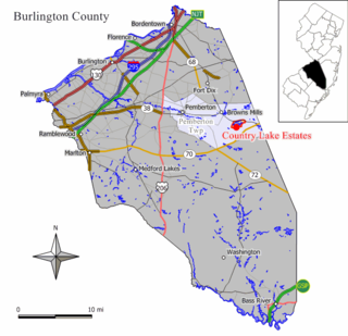
Country Lake Estates is an unincorporated community and census-designated place (CDP) located within Pemberton Township, in Burlington County, in the U.S. state of New Jersey. As of the 2010 United States Census, the CDP's population was 3,943.

<span class="mw-page-title-main">Presidential Lakes Estates, New Jersey</span> Census-designated place in New Jersey, United States

Presidential Lakes Estates is an unincorporated community and census-designated place (CDP) located within Pemberton Township, in Burlington County, in the U.S. state of New Jersey. As of the 2010 United States Census, the CDP's population was 2,365.

<span class="mw-page-title-main">Greentree, New Jersey</span> Populated place in Camden County, New Jersey, US

Greentree is an unincorporated community and census-designated place (CDP) located within Cherry Hill Township, in Camden County, in the U.S. state of New Jersey. As of the 2010 United States Census, the CDP's population was 11,367.

<span class="mw-page-title-main">Laurel Lake, New Jersey</span> Census-designated place in New Jersey

Laurel Lake is an unincorporated community and census-designated place (CDP) located within Commercial Township, in Cumberland County, in the U.S. state of New Jersey. It is part of the Vineland-Millville-Bridgeton Primary Metropolitan Statistical Area for statistical purposes. As of the 2010 United States Census, the CDP's population was 2,989.

<span class="mw-page-title-main">Victory Lakes, New Jersey</span> Census-designated place in New Jersey, United States

Victory Lakes is an unincorporated community and census-designated place (CDP) located within Monroe Township, in Gloucester County, in the U.S. state of New Jersey. As of the 2010 United States Census, the CDP's population was 2,111.

<span class="mw-page-title-main">Heathcote, New Jersey</span> Census-designated place in New Jersey, United States

Heathcote is an unincorporated community and census-designated place (CDP) located within South Brunswick Township, in Middlesex County, in the U.S. state of New Jersey. As of the 2010 United States Census, the CDP's population was 5,821.

<span class="mw-page-title-main">Old Bridge (CDP), New Jersey</span> Census-designated place in New Jersey, United States

Old Bridge is a census-designated place (CDP) in Old Bridge Township, in Middlesex County, in the U.S. state of New Jersey. As of the 2010 United States Census, the CDP's population was 23,753. Despite the similarity in the name of the CDP and the township, the two are not one and the same, as had been the case for most paired Township / CDP combinations prior to the 2010 Census, in which the CDP was coextensive with a township of the same name.

<span class="mw-page-title-main">Shark River Hills, New Jersey</span> Census-designated place in New Jersey, United States

Shark River Hills is an unincorporated community and census-designated place (CDP) within Neptune Township, in Monmouth County, in the U.S. state of New Jersey. As of the 2010 United States Census, the CDP's population was 3,697.

<span class="mw-page-title-main">Lake Telemark, New Jersey</span> Census-designated place in New Jersey, United States

Lake Telemark is an unincorporated community and census-designated place (CDP) located within Rockaway Township, in Morris County, in the U.S. state of New Jersey. As of the 2010 United States Census, the CDP's population was 1,255.

<span class="mw-page-title-main">White Meadow Lake, New Jersey</span> Census-designated place in New Jersey, United States

White Meadow Lake is an unincorporated community and census-designated place (CDP) located within Rockaway Township, in Morris County, in the U.S. state of New Jersey. As of the 2010 United States Census, the CDP's population was 8,836.

<span class="mw-page-title-main">Barnegat (CDP), New Jersey</span> Populated place in Ocean County, New Jersey, US

Barnegat is an unincorporated community and census-designated place (CDP) located within Barnegat Township, in Ocean County, in the U.S. state of New Jersey. As of the 2010 United States census, the CDP's population was 2,817.

<span class="mw-page-title-main">Cedar Glen Lakes, New Jersey</span> Populated place in Ocean County, New Jersey, US

Cedar Glen Lakes is an unincorporated community and census-designated place (CDP) located within Manchester Township, in Ocean County, in the U.S. state of New Jersey. As of the 2010 United States Census, the CDP's population was 1,421.

<span class="mw-page-title-main">Holiday City South, New Jersey</span> Census-designated place in New Jersey, United States

Holiday City South is an unincorporated community and census-designated place (CDP) located within Berkeley Township, in Ocean County, in the U.S. state of New Jersey. As of the 2010 United States Census, the CDP's population was 3,689.

<span class="mw-page-title-main">Holiday Heights, New Jersey</span> Census-designated place in New Jersey, United States

Holiday Heights is an unincorporated community and census-designated place (CDP) located within Berkeley Township, in Ocean County, in the U.S. state of New Jersey. As of the 2010 United States Census, the CDP's population was 2,099.

<span class="mw-page-title-main">Leisure Village West-Pine Lake Park, New Jersey</span> Census-designated place in New Jersey, United States

Leisure Village West-Pine Lake Park is an unincorporated community and census-designated place (CDP) located within Manchester Township, in Ocean County, New Jersey, United States. As of the 2000 United States Census, the CDP's population was 11,085. For the 2010 Census the area was split into two CDPs, Leisure Village West and Pine Lake Park.

<span class="mw-page-title-main">Crandon Lakes, New Jersey</span> Populated place in Sussex County, New Jersey, US

Crandon Lakes is an unincorporated community and census-designated place (CDP) split between Hampton Township and Stillwater Township, in Sussex County, in the U.S. state of New Jersey. As of the 2010 United States Census, the CDP's population was 1,178, of which 682 were in Hampton Township and 496 in Stillwater Township.

<span class="mw-page-title-main">Leisure Village West, New Jersey</span> Census-designated place in New Jersey, United States

Leisure Village West is an unincorporated community and census-designated place (CDP) located within Manchester Township, in Ocean County, in the U.S. state of New Jersey. Until the 2000 census, the CDP had been part of the Leisure Village West-Pine Lake Park CDP, which was split for the 2010 enumeration into separate CDPs for Leisure Village West and Pine Lake Park. As of the 2010 United States Census, the CDP's population was 3,493. Leisure Village West is one of several active adult communities bearing similar names. Leisure Village and Leisure Village East are the other two communities nearby.

<span class="mw-page-title-main">Oxford (CDP), New Jersey</span> Census-designated place in New Jersey, United States

Oxford is an unincorporated community and census-designated place (CDP) located within Oxford Township in Warren County, New Jersey, United States, that was created as part of the 2010 United States Census. As of the 2010 Census, the CDP's population was 1,090.

Mountain Lake is an unincorporated community and census-designated place (CDP) located within Liberty Township in Warren County, in the U.S. state of New Jersey, that was created as part of the 2010 United States Census. As of the 2020 United States census, the CDP's population was 494 a decrease of 81 (−14.1%) from the 575 recorded at the 2010 census.

<span class="mw-page-title-main">Clearbrook, New Jersey</span> Populated place in Middlesex County, New Jersey, US

Clearbrook is a gated community and census-designated place (CDP) in Monroe Township, Middlesex County, in the U.S. state of New Jersey. It is in the western part of the township, bordered to the north by Encore at Monroe and to the east by Concordia and The Ponds. It is 3.5 miles (5.6 km) southwest of Jamesburg and 5 miles (8 km) northeast of Hightstown.

References

  1. 1 2 3 4 Gazetteer of New Jersey Places, United States Census Bureau. Accessed July 21, 2016.
  2. 1 2 US Gazetteer files: 2010, 2000, and 1990, United States Census Bureau. Accessed September 4, 2014.
  3. "ArcGIS REST Services Directory". United States Census Bureau. Retrieved October 11, 2022.
  4. U.S. Geological Survey Geographic Names Information System: Collings Lakes Census Designated Place, Geographic Names Information System. Accessed June 16, 2013.
  5. 1 2 "Census Population API". United States Census Bureau. Retrieved October 11, 2022.
  6. Look Up a ZIP Code for Collings Lakes, NJ, United States Postal Service. Accessed June 16, 2013.
  7. 1 2 U.S. Census website, United States Census Bureau. Accessed September 4, 2014.
  8. Geographic codes for New Jersey, Missouri Census Data Center. Accessed June 9, 2023.
  9. US Board on Geographic Names, United States Geological Survey. Accessed September 4, 2014.
  10. GCT-PH1 - Population, Housing Units, Area, and Density: 2010 - County -- County Subdivision and Place from the 2010 Census Summary File 1 for Atlantic County, New Jersey Archived 2020-02-12 at archive.today , United States Census Bureau. Accessed June 16, 2013.
  11. 2006-2010 American Community Survey Geography for New Jersey, United States Census Bureau. Accessed June 16, 2013.
  12. 1 2 New Jersey: 2010 - Population and Housing Unit Counts - 2010 Census of Population and Housing (CPH-2-32), United States Census Bureau, p. III-5, August 2012. Accessed June 16, 2013.
  13. 1 2 3 4 5 DP-1 - Profile of General Population and Housing Characteristics: 2010 Demographic Profile Data for Collings Lakes CDP, New Jersey Archived 2020-02-12 at archive.today , United States Census Bureau. Accessed June 16, 2013.
  14. CITIZENS VOICES ASSOCIATION v. COLLINGS LAKES CIVIC ASSOCIATION, FindLaw. Accessed May 12, 2013.
  15. 1 2 3 4 5 DP-1 - Profile of General Demographic Characteristics: 2000 from the Census 2000 Summary File 1 (SF 1) 100-Percent Data for Collings Lakes CDP, New Jersey Archived 2020-02-12 at archive.today , United States Census Bureau. Accessed June 16, 2013.