Combe Down and Bathampton Down Mines

Last updated

Combe Down and Bathampton Down Quarries
Site of Special Scientific Interest
Firs quarry.jpg
Somerset UK location map.svg
Red pog.svg
Location within Somerset
Location Avon
Grid reference ST761625
Coordinates 51°21′40″N2°20′41″W / 51.36106°N 2.34465°W / 51.36106; -2.34465
InterestBiological
Area15.37 acres (0.0622 km2; 0.02402 sq mi)
Notification 1991 (1991)
Natural England website

Combe Down and Bathampton Down Quarries (grid reference ST761625 ) make up a 6.22 hectare (15.37 acre) Site of Special Scientific Interest (SSSI) in Bath and North East Somerset, England, important for its bat population. The disused quarries date from the 17th and 18th centuries and were the source of Bath stone for the city of Bath and elsewhere in the UK. A five-year project to stabilise the quarry workings was largely completed by November 2009.

Contents

Geology

Combe Down forms a plateau capped by Great Oolite limestones between the valley of the River Avon and Horsecombe Vale. The geology of the region is dominated by rocks of Middle and Early Jurassic ages. The Great Oolite is the uppermost lithology, underlain by the clays of the Fuller's Earth Formation, which in turn is underlain by limestones of the Inferior Oolite and the Midford Sands of the Lias. The Great and Inferior Oolite formations provide effective aquifers (rock in which water can be stored and pass through) for public and private water supplies. [1]

History

The stone from the Great Oolite Group (Forest Marble, Bath Oolite, Twinhoe Beds and Combe Down Oolite), used for building purposes, formed over 146 million years ago when the area was underneath a deep tropical sea on which ooliths were deposited. The ooliths bonded together to form the distinctive rock known as oolitic limestone or locally as Bath stone. The Romans found that it was easily worked and used it for important fortifications. During the 17th century, small quarries were opened, with major quarries being developed in the 18th century to produce the stone used for many of the buildings in Bath and elsewhere in the UK, including Buckingham Palace. Stone was extracted by the "room and pillar" method, by which chambers were mined, leaving pillars of stone to support the roof. [1] These mines were once owned by Postmaster General Ralph Allen (1694–1764).

The mines contain a range of features including well preserved tramways, cart-roads and crane bases. The walls and pillars are studded with pick and tool marks and show evidence of the use of huge stone saws, all of which bear testimony to the variety of techniques used to extract the stone over their three hundred-year history. [2]

No mine abandonment plans – either of the tunnels or the caverns, known as voids – were made prior to the 1872 Mining Act. [1]

During 1989 a utilities contractor unexpectedly broke through into part of the mine complex whilst excavating a trench, which resulted in Bath City Council commissioning studies to survey the condition of the mines. It was clear that the mines were in very unstable condition, and some experts considered them to be the largest, shallowest and most unstable of their kind in Europe. [3]

Mine and environmental survey

An underground survey of the Firs and Byfield mine areas was carried out in 1994, commissioned by Bath City Council. It was found that approximately 80% of the mines had less than 6 m cover, reducing to 2 m in some places. [4] Irregular mining and robbing stone from supporting pillars had left the mines unstable. [1]

An Environmental Impact Assessment was completed for the stabilisation scheme and submitted to the Local Planning Authority in December 2002. This highlighted that the mine is within the World Heritage Site of the City of Bath; adjacent to the Cotswold Area of Outstanding Natural Beauty (AONB); within a conservation area, containing a number of listed buildings; a Site of Special Scientific Interest; a candidate Special Area of Conservation; of international importance for Greater and Lesser Horseshoe bats; and of international geological importance, partly due to the work of William Smith. [1]

During the access and emergency works, Oxford Archaeology produced large scale plans of visible areas and substantial photography was carried out as the modern roadways allowed access. There were also trials of video photography and laser scanning, so that a substantial record was produced of some 20% of the known workings. [2]

The mine also lies above a Grade 1 aquifer from which water for public and private use is extracted via the springs that issue at the base of these units, in particular at the Prior Park, Whittaker and Tucking Mill springs. [1]

Mine stabilisation project

In March 1999, the then Department of Environment, Transport and Regions (DETR) announced a Land Stabilisation Programme, based on the Derelict Land Act 1982. This was designed to "deal with abandoned non-coal mine workings which are likely to collapse and threaten life and property". A Bath and North East Somerset Council outline bid for a two-phase stabilisation project was accepted in August 1999, by English Partnerships who administered the programme for the then Office of the Deputy Prime Minister. [1] A parliamentary Statutory Instrument (2002 No. 2053) was needed before the work could be undertaken. [5]

Approximately 760 properties were included within the planning application boundary; estimates were that ca. 1660 people lived within this area, which also included a primary school, a nursery and three churches.

Foamed concrete was selected for the large-scale infilling of the old mine works: the single largest application of foamed concrete on a project in the UK. The work was largely complete by November 2009, by which time approximately 600,000 cubic metres of foamed concrete had been used to fill 25 hectares of very shallow limestone mine, making it the largest project of its kind in the world. [6]

Biological interest

Greater Horseshoe bat Grosse Hufeisennase-drawing.jpg
Greater Horseshoe bat

The site was notified as a Site of Special Scientific Interest in 1991, for its importance as a hibernation site for several species of bat, including Greater and Lesser Horseshoe. [7] Since 2005 it has formed part of the Bath and Bradford-on-Avon Bats Special Area of Conservation. [8]

Related Research Articles

<span class="mw-page-title-main">Box Tunnel</span> Railway tunnel in western England

Box Tunnel passes through Box Hill on the Great Western Main Line (GWML) between Bath and Chippenham. The 1.83-mile (2.95 km) tunnel was the world's longest railway tunnel when it was completed in 1841.

<span class="mw-page-title-main">Oolite</span> Sedimentary rock formed from ooids

Oolite or oölite is a sedimentary rock formed from ooids, spherical grains composed of concentric layers. Strictly, oolites consist of ooids of diameter 0.25–2 millimetres; rocks composed of ooids larger than 2 mm are called pisolites. The term oolith can refer to oolite or individual ooids.

<span class="mw-page-title-main">Combe Down</span> Village on the outskirts of Bath, United Kingdom

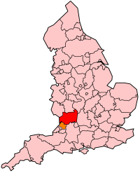
Combe Down is a village on the outskirts of Bath, England, in the Bath and North East Somerset unitary authority area, within the ceremonial county of Somerset.

<span class="mw-page-title-main">Prior Park</span> Grade I listed Palladian building in south west England

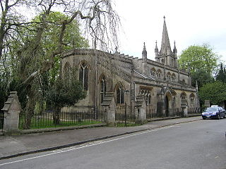
Prior Park is a Neo-Palladian house that was designed by John Wood, the Elder, and built in the 1730s and 1740s for Ralph Allen on a hill overlooking Bath, Somerset, England. It has been designated as a Grade I listed building.

<span class="mw-page-title-main">Bathampton</span> Human settlement in England

Bathampton is a village and civil parish 2 miles (3 km) east of Bath, England on the south bank of the River Avon. The parish has a population of 1,603.

<span class="mw-page-title-main">Bath stone</span> Oolitic limestone from Somerset used as a building material

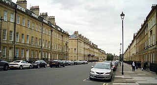
Bath Stone is an oolitic limestone comprising granular fragments of calcium carbonate originally obtained from the Middle Jurassic aged Great Oolite Group of the Combe Down and Bathampton Down Mines under Combe Down, Somerset, England. Its honey colouring gives the World Heritage City of Bath, England its distinctive appearance. An important feature of Bath Stone is that it is a 'freestone', so-called because it can be sawn or 'squared up' in any direction, unlike other rocks such as slate, which form distinct layers.

<span class="mw-page-title-main">Geology of Somerset</span>

Somerset is a rural county in the southwest of England, covering 4,171 square kilometres (1,610 sq mi). It is bounded on the north-west by the Bristol Channel, on the north by Bristol and Gloucestershire, on the north-east by Wiltshire, on the south-east by Dorset, and on the south west and west by Devon. It has broad central plains with several ranges of low hills. The landscape divides into four main geological sections from the Silurian through the Devonian and Carboniferous to the Permian which influence the landscape, together with water-related features.

<span class="mw-page-title-main">Mine exploration</span> Hobby of visiting abandoned mines

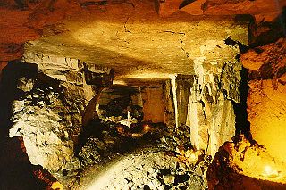
Mine exploration is a hobby in which people visit abandoned mines, quarries, and sometimes operational mines. Enthusiasts usually engage in such activities for the purpose of exploration and documentation, sometimes through the use of surveying and photography. In this respect, mine exploration might be considered a type of amateur industrial archaeology. In many ways, however, it is closer to caving, with many participants actively interested in exploring both mines and caves. Mine exploration typically requires equipment such as helmets, head lamps, Wellington boots, and climbing gear.

<span class="mw-page-title-main">Compton Martin Ochre Mine</span>

Compton Martin Ochre Mine is a 0.85 hectare geological and biological Site of Special Scientific Interest located on the north side of the Mendip Hills, immediately south west of Compton Martin village, Somerset, notified in 1988.

<span class="mw-page-title-main">Browne's Folly</span> Site of a tower with the same name

Browne's Folly or Brown's Folly is a folly tower sitting within a 39.9 hectare biological and geological Site of Special Scientific Interest (SSSI) near the village of Bathford in Somerset, notified in 1974: the site itself is known as the Farleigh Down Stone Quarry, and is managed as a nature reserve by the Avon Wildlife Trust (AWT). The tower was built in 1848 and is a Grade II listed building.

<span class="mw-page-title-main">Cheddar Complex</span> Site of Special Scientific Interest in Somerset, England

The Cheddar Complex is a 441.3-hectare (1,090-acre) biological Site of Special Scientific Interest near Cheddar around the Cheddar Gorge and north east to Charterhouse in the Mendip Hills, Somerset, England, notified in 1952.

<span class="mw-page-title-main">Chilmark Quarries</span> Stone quarry in Wiltshire, England

Chilmark Quarries is a 9.65 hectare biological and geological Site of Special Scientific Interest (SSSI), in the ravine south of the village of Chilmark in Wiltshire, England.

<span class="mw-page-title-main">Box Mine</span>

Box Mine is a 56.6 ha biological Site of Special Scientific Interest, near the village of Box in Wiltshire, England, notified in 1991.

Winsley Mines is a 1.48 hectare biological Site of Special Scientific Interest, near the village of Winsley in Wiltshire, England, notified in 1989.

<span class="mw-page-title-main">Bathampton Down</span> Limestone plateau in Somerset, England

Bathampton Down is a flat limestone plateau in Bathampton, Somerset, England, overlooking the River Avon and the city of Bath. There is evidence of man's activity at the site since the Mesolithic period including Bathampton Camp, an Iron Age hillfort or stock enclosure. It has also been used for quarrying, and part of it is now a golf course.

<span class="mw-page-title-main">Geology of Gloucestershire</span>

Gloucestershire is one of the most geologically and scenically diverse counties in England, with rocks from the Precambrian through to the Jurassic represented. These varying rock-types are responsible for the three major areas of the county, each with its own distinctive scenery and land-use - the Forest of Dean in the west, bordering Wales, the Cotswolds in the east, and in between, the Severn Vale.

<span class="mw-page-title-main">Winsley</span> Human settlement in England

Winsley is a large village and civil parish about 2 miles (3 km) west of Bradford on Avon in Wiltshire, England.

<span class="mw-page-title-main">Beer Quarry Caves</span> Man-made caves in Devon, England

Beer Quarry Caves is a man-made limestone underground complex located about a mile west of the village of Beer, Devon, and the main source in England for beer stone. The tunnels resulted from 2,000 years of quarrying beer stone, which was particularly favoured for cathedral and church features such as door and window surrounds because of its colour and workability for carving. Stone from the quarry was used in the construction of several of southern England's ancient cathedrals and a number of other important buildings as well as for many town and village churches, and for some buildings in the United States. Extraction was particularly intense during the Middle Ages, but continued until the 1920s. An adit to another set of workings can be seen from the South West Coast Path east of Branscombe, having been exposed by a landslip in the late 18th century. The quarry is part of the Jurassic Coast, and is a Site of Special Scientific Interest (SSSI).

<span class="mw-page-title-main">Crickley Hill and Barrow Wake</span> Site of Special Scientific Interest in Gloucestershire

Crickley Hill and Barrow Wake is a 56.8-hectare (140-acre) biological and geological Site of Special Scientific Interest in Gloucestershire, notified in 1974.

<span class="mw-page-title-main">Bath and Bradford-on-Avon Bats SAC</span>

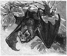
The Bath and Bradford-on-Avon Bats SAC is a Special Area of Conservation originally designated under the European Union's Habitats Directive (92/43/EEC), also known as the Directive on the Conservation of Natural Habitats and of Wild Fauna and Flora.

References

  1. 1 2 3 4 5 6 7 "Combe Down Stone Mines Land Stabilisation Project". BANES. Archived from the original on 17 January 2006. Retrieved 13 July 2006.
  2. 1 2 "Combe Down Mines". Oxford Archeology. Retrieved 7 October 2010.
  3. "Combe Down Mines". ISSMGE: 5th International Congress on Environmental Geotechnic. Retrieved 13 July 2006.
  4. "Combe Down Stone Mines Project". Scott Wilson. Archived from the original on 5 May 2006. Retrieved 13 July 2006.
  5. "The Derelict Land Clearance Area (Combe Down Stone Mines, Bath) Order 2002". Statutory Instruments HMSO, the Queen's Printer of Acts of Parliament. Archived from the original on 21 October 2008. Retrieved 13 July 2006.
  6. Tipping, Christopher. "'1479 plates', Combe Down Stone Mines Project". Axisweb. Retrieved 29 August 2017.
  7. "Combe Down and Bathampton Down Mines" (PDF). English Nature SSSI Citation Sheet. 1991. Archived from the original (PDF) on 23 February 2017.
  8. "Bath and Bradford-on-Avon Bats Special Area of Conservation" (PDF). Natural England . 20 March 2019. Archived from the original on 8 February 2021. Retrieved 8 February 2021.