Hurricane Mills is an unincorporated community in Humphreys County, Tennessee, United States. Its ZIP code is 37078.
Utleyville is an unincorporated community in Baca County, Colorado, United States. It is approximately 32 driving miles west-southwest of Springfield.

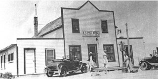
Eva is an unincorporated community and census-designated place (CDP) in Benton County, Tennessee, on the western shore of the Kentucky Lake impoundment of the Tennessee River. It is the site of Nathan Bedford Forrest State Park. As of the 2010 census, its population was 293. The ZIP Code Tabulation Area for the ZIP code (38333) that serves Eva had a population of 574 as of the 2000 U.S. Census, when Eva was not yet a CDP. Eva is centered on the junction of State Route 191, which connects the community to Nathan Bedford Forrest State Park to the north and the town of Camden to the south, and Eva Beach Road, which stretches from the center of the community to its beach along Kentucky Lake.
Climbing Hill is an unincorporated community in Woodbury County, Iowa, United States. Its elevation is 1,135 feet (346 m). The community is part of the Sioux City, IA–NE–SD Metropolitan Statistical Area. It has a post office with the ZIP code 51015.
Dewar is an unincorporated town in eastern Black Hawk County, Iowa, United States. It lies northeast of the city of Waterloo, the county seat of Black Hawk County. Its elevation is 889 feet (271 m). Although Dewar is unincorporated, it has a post office with the ZIP code of 50623, which opened on 25 October 1887.
Oran is an unincorporated community in southwestern Fayette County, Iowa, United States. It lies along local roads southwest of the city of West Union, the county seat of Fayette County, and west of the city of Oelwein, the largest city in Fayette County. Its elevation is 1,043 feet (318 m). Although Oran is unincorporated, it has a post office with the ZIP code of 50664.
Conroy is an unincorporated community and census-designated place (CDP) in central Iowa County, Iowa, United States. It lies along local roads southeast of the city of Marengo, the county seat of Iowa County. Its elevation is 879 feet (268 m). Conroy has a post office with the ZIP Code of 52220, which opened on 5 January 1885. As of the 2010 census the population was 259.
Kesley is an unincorporated community in southwestern Butler County, Iowa, United States. It lies along local roads southwest of the city of Allison, the county seat of Butler County. Its elevation is 1,001 feet (305 m). Although Kesley is unincorporated, it has a post office with the ZIP code of 50649.
Liberty Center is an unincorporated community in southern Warren County, Iowa, United States. It lies along U.S. Route 65 south of the city of Indianola, the county seat of Warren County. Its elevation is 1,024 feet (312 m), and it is located at about 41°12′16″N93°30′0″W. Although Liberty Center is unincorporated, it has a post office, with the ZIP code of 50145, which opened on 7 March 1865.
Prole is an unincorporated rural village in northwestern Warren County, Iowa, United States. It lies along Iowa Highway 28 northwest of the city of Indianola, the county seat of Warren County. Its elevation is 978 feet (298 m). Prole has a post office, with the ZIP code of 50229, a cafe, a floral shop and an auto repair shop by way of businesses and services.
Bryant is an unincorporated community in northeastern Clinton County, Iowa, United States. It lies along local roads northwest of the city of Clinton, the county seat of Clinton County. Its elevation is 804 feet (245 m). Bryant is unincorporated, with the ZIP code of 52727, which opened as Ten Mile House on 25 August 1870 and changed its name to Bryant on 15 March 1871.
Pilot Grove is an unincorporated community in northern Lee County, Iowa, United States. It lies along local roads northwest of the city of Fort Madison, the county seat of Lee County. Its elevation is 643 feet (196 m).

Elora is an unincorporated community in Lincoln County, Tennessee, United States. It lies approximately 16 miles (26 km) southeast of Fayetteville and 2 miles (3.2 km) north of the Alabama state line. It has a post office with zip code 37328.

Turtletown is an unincorporated community in Polk County, Tennessee, United States. Turtletown is located on Tennessee State Route 68 6.5 miles (10.5 km) north-northeast of Ducktown. Turtletown is in a primarily mountainous terrain, covered in forests except for areas cleared by farmers, ponds, or roads. Turtletown has a post office with ZIP code 37391. Turtletown's borders, however, in the eyes of some are disputed. According to one, parts of it are known as Dogtown, which appears on a few local maps. However, to others, it is simply all Turtletown and Dogtown does not exist. The only known map that contains this is the USGS map of the area, and a U.S. Forest Service map. There is an abandoned school, Turtletown School, across the street from the Post Office.
Delano is an unincorporated community in Polk County, Tennessee, United States. It is located near the junction of U.S. Route 411, Tennessee State Route 30 and Tennessee State Route 163 4.3 miles (6.9 km) south-southwest of Etowah. Delano has a post office with ZIP code 37325, which opened on August 14, 1909.

Reliance is an unincorporated community in Polk County, Tennessee, United States. Reliance is located on the Hiwassee River at the junction of Tennessee State Route 30 and Tennessee State Route 315, 8.8 miles (14.2 km) east of Benton. Reliance had a post office until it closed on May 21, 2011; it still has its own ZIP code, 37369.
Lake Como is an unincorporated community located in Putnam County, Florida, United States. The zip code is: 32157. The community is located along Old Highway 17 between Crescent City and Pomona Park.
Pickwick Dam is an unincorporated community in Hardin County, Tennessee, United States. Pickwick Dam is located on the Tennessee River south of the Pickwick Landing Dam. Pickwick Dam has a post office with ZIP code 38365.

Pruden is an unincorporated community located partly in Bell County, Kentucky and partly in Claiborne County, Tennessee, in the southeastern United States. It is located along Tennessee State Route 90 and Kentucky Route 74, which intersect at the state line, in the upper Clearfork Valley.
Summitville is an unincorporated community in Coffee County, Tennessee, United States. Summitville is located along the Caney Fork and Western Railroad near Tennessee State Route 55, 7.6 miles (12.2 km) northeast of Manchester. Summitville has a post office with ZIP code 37382, which opened on June 5, 1877. The Crouch-Ramsey Family Farm, which is listed on the National Register of Historic Places, is located near Summitville.


