Related Research Articles

Nicollet Avenue is a major street in Minneapolis, Richfield, Bloomington, and Burnsville in the U.S. state of Minnesota. It passes through a number of locally well-known neighborhoods and districts, notably Eat Street in south Minneapolis and the traffic-restricted Nicollet Mall in downtown Minneapolis.

Lowry Hill East, also known as the Wedge, is a neighborhood in southwest Minneapolis, Minnesota, United States, part of the Calhoun Isles community. Lowry Hill East developed in the 1880s along a horse-drawn streetcar line built by Thomas Lowry. The interior of the neighborhood is residential, with large early 20th century homes and multi-unit apartment buildings, while the border streets are lined with bars, restaurants, grocery stores, coffeeshops, and other small businesses. Most housing is renter-occupied.

South Uptown is a residential neighborhood of Minneapolis, Minnesota. In 2018, the neighborhood voted to change its name to South Uptown from its former name CARAG. Other potential names for the neighborhood included "Bryant Park" and "Bryant Square". The Minneapolis City Council approved the name change in November 2018.

Hale is a neighborhood near the southern edge of Minneapolis. It lies south of Minnehaha Creek, north of 55th Street, east of Chicago Avenue, and west of Cedar Avenue. The neighborhood takes its name from the local public school, Nathan Hale. Nathan Hale is a K-4 school. Most of the homes in the area were built in the 1920s and 30s. The regional parks forming the neighborhood's north and east borders give the neighborhood a recreational heart.

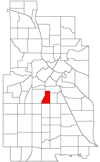
Bancroft is a neighborhood within the Powderhorn community in Minneapolis, Minnesota, United States. Its boundaries are East 38th Street to the north, Chicago Avenue to the west, East 42nd Street to the south and Cedar Avenue to the east.

Stadium Village is an area of Minneapolis, Minnesota near the East Bank campus of the University of Minnesota. While not an official neighborhood of

Downtown West is an official neighborhood in Minneapolis, part of the larger Central community. It is the heart of downtown Minneapolis, containing the bulk of high-rise office buildings in the city, and is what comes to mind when most Minneapolitans think of "downtown".

Marcy-Holmes is a neighborhood in the University community of Minneapolis. The majority of the area is residential and sits upon a bluff overlooking the river and the city skyline. However, a small section of the neighborhood along the river is an industrial zone.
Phillips West is a neighborhood within the Phillips community in Minneapolis. Its boundaries are East 22nd Street to the north, Chicago Avenue to the east, East Lake Street to the south, and Interstate 35W to the west. The Phillips community has only been subdivided into smaller neighborhoods within the last couple years; the boundaries of Phillips West were officially designated on April 29, 2005. As this change has been fairly recent, most residents still refer to the area as just "Phillips".

Como is a neighborhood within the University community of Minneapolis. It is sometimes referred to as Southeast Como, due to many of its streets ending in SE, and possibly to differentiate it from the Como neighborhood in neighboring Saint Paul. Its boundaries are East Hennepin Avenue to the north, 33rd Avenue Southeast to the east, the Southeast Industrial Area to the south, and Interstate 35W to the west.

Cedar-Isles-Dean is a neighborhood in the Calhoun-Isles community in Minneapolis. Its boundaries are the Kenilworth Lagoon and Lake of the Isles to the north and east, West Lake Street to the south, and France Avenue South to the west. Nearby neighborhoods include Bryn Mawr and Kenwood to the north, East Isles to the east, East Bde Maka Ska to the southwest, and West Maka Ska to the south. To the west is the suburb of Saint Louis Park. The neighborhood, one of the most affluent in the city, takes its name from Cedar Lake, Lake of the Isles, and Dean Parkway.

Saint Anthony Park is a neighborhood in northwest Saint Paul, Minnesota. It is adjacent to the University of Minnesota's St. Paul Campus, bordering Prospect Park, Minneapolis on the west, the Minnesota State Fairgrounds on the east, and the suburbs of Falcon Heights and Lauderdale to the north.

The Gateway District of Minneapolis is centered at the convergence of Hennepin Avenue, Nicollet Avenue, and Washington Avenue. Its borders are not officially designated or recognized, but are visible as the Mississippi River to the northeast, Cedar Lake Trail and the railroad tracks to the northwest, Fifth Avenue South to the southeast. and Fourth Street South to the southwest. The district includes a significant part of the Downtown West neighborhood and abuts the North Loop.
The U of M Transitway is a busway that runs between the University of Minnesota's Minneapolis and St. Paul campuses. Use of the roadway is limited to buses, bicycles, and emergency vehicles. The University of Minnesota runs zero-fare buses along the busway connecting the two campuses, primarily the Campus Connector but also shuttles to and from the St. Paul campus for football games. A bicycle trail runs alongside the transitway for most of its distance. Between the endpoints, there are only two intersections with stoplights controlling busway traffic at Energy Park Drive and Como Avenue. The stoplights are designed to normally give the buses priority, so it is possible for many buses to run the length of the transitway without stopping.

Keewaydin is a neighborhood in the Nokomis community in Minneapolis, Minnesota. Its boundaries are Minnehaha Parkway to the north, 34th Avenue to the east, 54th Street to the south, and Cedar Avenue to the west. The neighborhood contains the majority of Lake Nokomis. It shares a neighborhood organization with the Minnehaha, Morris Park, and Wenonah neighborhoods, which are collectively referred to as Nokomis East and served by the Nokomis East Neighborhood Association (NENA).
Wenonah is a neighborhood on the southeast side of Minneapolis, Minnesota. Its boundaries are 54th Street to the north, 34th Avenue to the east, the Minneapolis-Saint Paul International Airport to the south, and Cedar Avenue to the west. The neighborhood contains a portion of Lake Nokomis. It shares a neighborhood organization with the Keewaydin, Minnehaha, and Morris Park neighborhoods, which are collectively referred to as Nokomis East and are served by the Nokomis East Neighborhood Association (NENA).

Lynnhurst is a neighborhood in the Southwest community in Minneapolis, Minnesota. Its boundaries are 46th Street to the north, Lyndale Avenue to the east, 54th Street to the south, and Penn Avenue to the west. It is located along the southeastern shore of Lake Harriet. Outflows from the lake run through a parkway for several city blocks to reach Minnehaha Creek.

Frogtown is a neighborhood in Saint Paul in the U.S. state of Minnesota. Built around University Avenue, the Thomas-Dale neighborhood is colloquially known as Frogtown. Historically, Frogtown was a subsection of the current Thomas-Dale neighborhood. It is bordered by University Avenue on the south, the Burlington Northern Railroad tracks to the north, Lexington Parkway on the west and Rice Street on the east.

Union Park is a neighborhood in Saint Paul in the U.S. state of Minnesota. Created as a merger of several historic neighborhoods including Merriam Park, Snelling-Hamline, Parts of Midway, Densoyer Park, and Lexington-Hamline, it is bordered by University Avenue on the north, Lexington Parkway on the east, Summit Avenue on the south, and the Mississippi National River and Recreation Area on the west. Despite the merger, many of the historic neighborhoods hold onto their original identity, especially in Lexington-Hamline and Merriam Park.

Corcoran is a neighborhood within the Powderhorn community in Minneapolis, Minnesota, United States. The neighborhood is bordered by Longfellow and Howe neighborhoods to the east, Phillips to the north, Powderhorn Park to the west and Standish to the south. Its official boundaries are East Lake Street to the north, Hiawatha Avenue to the east, East 36th Street to the south, and Cedar Avenue to the west.
References
- ↑ Como Neighborhood History Project Retrieved on February 2nd, 2024