Congo Pedicle

Last updated
Zambia's butterfly shape formed by the Congo Pedicle LocationZambia.png
Zambia's butterfly shape formed by the Congo Pedicle

The Congo Pedicle (at one time referred to as the Zaire Pedicle; in French la botte du Katanga, meaning 'Katanga boot') is the southeast salient of the Haut-Katanga Province of the Democratic Republic of the Congo, which divides neighbouring Zambia into two lobes. In area, the pedicle is similar in size to Wales or New Jersey. 'Pedicle' is used in the sense of 'a little foot'. 'Congo Pedicle' or 'the Pedicle' is also used to refer to the Congo Pedicle road, which crosses it.

Contents

The Congo Pedicle is an example of the boundaries imposed by European powers on Africa in the wake of the Scramble for Africa, [1] which were set by European interests and usually did not consider pre-existing political or tribal boundaries. [2]

As it is located at the southeastern extremity in the country, its eastern end is closer to the capital cities of 17 other African countries than its own, Kinshasa.

British and Belgian territorial claims

Cecil Rhodes's British South Africa Company (BSAC) approached Katanga from the south, the Belgian King Leopold II's Congo Free State (CFS) approached from the northwest. Southeast Katanga was controlled by the Yeke or Garanganze kingdom of Msiri based at Bunkeya (see map[ which? ]), and the BSAC and CFS competed to sign treaties with him, while he tried to play one off against the other. [3]

After Msiri's death the CFS was quicker to consolidate their claim to Msiri's territory called 'Garanganza', and later Katanga, west up to the Luapula. Since 1885 they already had claimed land north of the Congo-Zambezi watershed. The BSAC were left with the land south of the watershed and east of the Luapula. The 1884–85 Berlin Conference was organised by Germany to resolve the outcome of the Scramble for Africa. It did not set the actual boundaries, but agreed areas of influence, including the CFS's control over the Congo. Detailed borders were left to bilateral negotiations. [3]

Map showing the Congo Pedicle relative to the borders formed by the Luapula River and Congo-Zambezi watershed. Congo Pedicle map showing neighbouring Zambia.png
Map showing the Congo Pedicle relative to the borders formed by the Luapula River and Congo-Zambezi watershed.

Negotiating borders

The main problem of both the Belgian and British sides over the southeast Katanga border was the lack of an obvious geographical feature for the border to follow, as the Congo-Zambezi watershed boundary and the Luapula do not meet. Separated by a distance of 70 to 150 km (43.50 to 93.21 mi), they run in an arc curving southeast then northeast, running almost parallel but gradually getting closer, and would reach the highlands between Lakes Tanganyika and Nyasa if the Chambeshi River, considered the ultimate source stream of the Congo River, were accepted as being the same river as the Luapula.

From the British point of view, the obvious choice for the border would have been southwest to northeast line from the watershed to the Luapula. Failing agreement on that, a second option would be to continue southwards the line of the Luapula-Lake Mweru valley (longitude 28° 35' E) which forms the longest north–south part of the border, until it intersects the Congo-Zambezi watershed, so all of the country immediately east of a north–south line through Ndola would then be in Northern Rhodesia. [4] But the Belgians hoped for access to the rich game areas of the Bangweulu Wetlands and pressed for the borders to stick to the river and watershed. In negotiations for a treaty some 'trading' of territories was involved in northeast Congo, Sudan and Uganda. [5] There was also the question of how far east into the Bangweulu swamps and floodplain the Pedicle should extend. The king of Italy was called in to adjudicate, and he drew a north–south line (a line of longitude) through a point on the map where the Luapula was thought to exit from the Lake Bangweulu swamps, which gave birth to the Pedicle: 70 to 100 km (43.50 to 62.14 mi) wide and about 200 kilometres (120 mi) long.

Anglo-Belgian Agreement of 12 May 1884

The agreement was incorporated into this larger treaty, which dealt mainly with Equatoria.

Anglo-Belgian Boundary Commission, 1911–1914

It became apparent as the region was more closely surveyed that on the ground there were a number of problems. The Luapula does not always flow in a single channel; there are islands, swamps, multiple channels; and the main channel may change according to the river height. It is particularly confusing south of Bangweulu, where there is not one single clear channel exiting the swamps but a tangled mass of channels in swamps and floodplains tens of kilometres wide, and the Italian king's line of longitude crossed them at multiple points. [3]

An Anglo-Belgian Boundary Commission was established in 1911 to survey the boundaries on the ground, resolve the problems and mark the border with posts and timber towers used for triangulation. The Italian king's ruler was moved west to a point where it did cut a clearly defined channel in one place. Finally, the work was complete in 1914.

Consequences for Northern Rhodesia/Zambia

As a consequence of Katanga attaining the Pedicle, it gained a toehold in the Bangweulu Wetlands and potential mineral resources, although as it turned out, the division of the main copper orebody between the Congo and Northern Rhodesia was determined by the CongoZambezi watershed and would not have been affected by the existence or otherwise of the Pedicle. It was the BSAC's failure to get Msiri to sign up Garanganza as a British protectorate which lost the Congolese Copperbelt to Northern Rhodesia, and some in the BSAC complained that the British missionaries Frederick Stanley Arnot and Charles Swan could have done more to help, although their Plymouth Brethren mission had a policy of not being involved in politics. [6] Once Msiri was killed by the CFS it was too late to try again, and consequently the leader of CFS expedition responsible, Canadian Captain William Grant Stairs was viewed by some in Northern Rhodesia as a traitor to the British Empire. [7]

Strategic issues for Zambia

The problems for Zambia did not emerge for another 50 years, with the Congo Crisis of 196063. The Pedicle cuts off the Luapula Province and the western part of the Northern Province from the country's industrial and commercial hub of the Copperbelt. This is exacerbated by the fact that at the Pedicle's toe tip, where the Luapula River ostensibly flows out of the Bangweulu system, the river swamps are at least 6 kilometres (3.7 mi) wide and the floodplain is 60 kilometres (37 mi) wide, [4] making a road impossible with the resources available for most of the 20th century. The most southerly road possible into Luapula keeping to Zambian territory was pushed, by these circumstances, another 200 kilometres (120 mi) north, going around Lake Bangweulu.

Strategically, the Congo Pedicle is an issue for Zambia, though not for DR Congo. As well as affecting communication for about one-quarter of the country with the centre and west, it potentially exposes a greater part of Zambia, which has generally enjoyed peace for more than 100 years, to conflict in Katanga, which has not. Zambia has witnessed violence in Katanga between armed factions and by the military against civilians which occasionally has spilled over into Zambia, or which has affected Zambians travelling on the Pedicle road. [8] At times, it has been closed to them making the huge detour around the north and east of Bangweulu the only option. Secondly, cross-border crime and arms smuggling has been a problem in the Copperbelt, as has poaching in the Bangweulu Wetlands. [9]

See also

Related Research Articles

<span class="mw-page-title-main">Lake Mweru</span> Lake in Zambia

Lake Mweru is a freshwater lake on the longest arm of Africa's second-longest river, the Congo. Located on the border between Zambia and Democratic Republic of the Congo, it makes up 110 kilometres (68 mi) of the total length of the Congo, lying between its Luapula River (upstream) and Luvua River (downstream) segments.

<span class="mw-page-title-main">Northern Rhodesia</span> 1911–1964 British protectorate in Southern Africa

Northern Rhodesia was a British protectorate in Southern Africa, now the independent country of Zambia. It was formed in 1911 by amalgamating the two earlier protectorates of Barotziland-North-Western Rhodesia and North-Eastern Rhodesia. It was initially administered, as were the two earlier protectorates, by the British South Africa Company (BSAC), a chartered company, on behalf of the British Government. From 1924, it was administered by the British Government as a protectorate, under similar conditions to other British-administered protectorates, and the special provisions required when it was administered by BSAC were terminated.

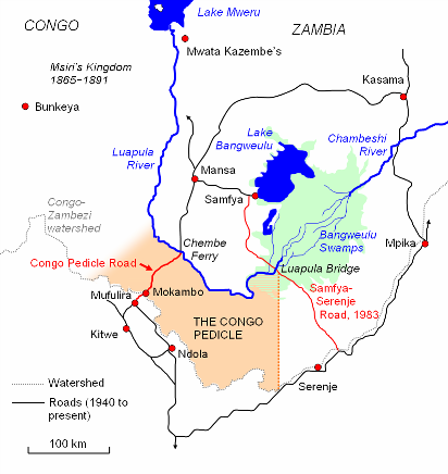
This article deals with the disputed area on the borders of the Democratic Republic of the Congo and Zambia, in Luapula Province.

<span class="mw-page-title-main">Lake Bangweulu</span> Lake in Zambia

Bangweulu — 'where the water sky meets the sky' — is one of the world's great wetland systems, comprising Lake Bangweulu, the Bangweulu Swamps and the Bangweulu Flats or floodplain. Situated in the upper Congo River basin in Zambia, the Bangweulu system covers an almost completely flat area roughly the size of Connecticut or East Anglia, at an elevation of 1,140 m straddling Zambia's Luapula Province and Northern Province. It is crucial to the economy and biodiversity of northern Zambia, and to the birdlife of a much larger region, and faces environmental stress and conservation issues.

<span class="mw-page-title-main">Luvua River</span> River in Katanga Province, Democratic Republic of the Congo

The Luvua River is a river in the Katanga Province of the Democratic Republic of the Congo (DRC). It flows from the northern end of Lake Mweru on the Zambia-Congo border in a northwesterly direction for 350 kilometres (220 mi) to its confluence with the Lualaba River opposite the town of Ankoro. The Lualaba becomes the Congo River below the Boyoma Falls.

<span class="mw-page-title-main">Luapula River</span> Tributary of the Congo River

The Luapula River is a section of Africa's second-longest river, the Congo. It is a transnational river forming for nearly all its length part of the border between Zambia and the DR Congo. It joins Lake Bangweulu to Lake Mweru and gives its name to the Luapula Province of Zambia.

<span class="mw-page-title-main">Kazembe</span>

Kazembe is a traditional kingdom in modern-day Zambia, and southeastern Congo. For more than 250 years, Kazembe has been an influential kingdom of the Kiluba-Chibemba, speaking the language of the Eastern Luba-Lunda people of south-central Africa. Its position on trade routes in a well-watered, relatively fertile and well-populated area of forestry, fishery and agricultural resources drew expeditions by traders and explorers who called it variously Kasembe, Cazembe and Casembe.

<span class="mw-page-title-main">Msiri</span> Founder and ruler of the Yeke Kingdom

Msiri founded and ruled the Yeke Kingdom in south-east Katanga from about 1856 to 1891. His name is sometimes spelled 'M'Siri' in articles in French. Other variants are "Mziri", "Msidi", and "Mushidi"; and his full name was Mwenda Msiri Ngelengwa Shitambi.

<span class="mw-page-title-main">Congo Pedicle road</span> Road in DR Congo

The Congo Pedicle road crosses the Congolese territory of the Congo Pedicle and was constructed by and is maintained by Zambia to connect its Copperbelt and Luapula Provinces. Both the road and the territory may be referred to as ‘the Pedicle’. It is designated as the N36 Route on the Congolese Road Network.

<span class="mw-page-title-main">Alfred Sharpe</span>

Sir Alfred Sharpe was Commissioner and Consul-General for the British Central Africa Protectorate and first Governor of Nyasaland.

Water transport and the many navigable inland waterways in Zambia have a long tradition of practical use except in parts of the south. Since draught animals such as oxen were not heavily used, water transport was usually the only alternative to going on foot until the 19th century. The history and current importance of Zambian waterways, as well as the types of indigenous boats used, provide information on this important aspect of Zambian economy.

<span class="mw-page-title-main">Chiengi</span> Place in Luapula Province, Zambia

Chiengi or is a historic colonial boma of the British Empire in central Africa and today is a settlement in the Luapula Province of Zambia, and headquarters of Chiengi District. Chiengi is in the north-east corner of Lake Mweru, and at the foot of wooded hills dividing that lake from Lake Mweru Wantipa, and overlooking a dambo stretching northwards from the lake, where the Chiengi rivulet flows down from the hills.

<span class="mw-page-title-main">Stairs Expedition to Katanga</span> Belgian expedition to claim Katanga in 1891–2

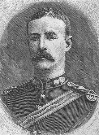
The Stairs Expedition to Katanga (1891−92), led by Captain William Stairs, was the winner in a race between two imperial powers, the British South Africa Company BSAC and the Congo Free State, to claim Katanga, a vast mineral-rich territory in Central Africa for colonization. The mission became notable when a local chief,, was killed, and also for the fact that Stairs, the leader of one side, actually held a commission in the army of the other.

The biomes and ecoregions in the ecology of Zambia are described, listed and mapped here, following the World Wildlife Fund's classification scheme for terrestrial ecoregions, and the WWF freshwater ecoregion classification for rivers, lakes and wetlands. Zambia is in the Zambezian region of the Afrotropical biogeographic realm. Three terrestrial biomes are well represented in the country . The distribution of the biomes and ecoregions is governed mainly by the physical environment, especially climate.

<span class="mw-page-title-main">Outline of Zambia</span> Overview of and topical guide to Zambia

The following outline is provided as an overview of and topical guide to Zambia:

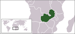
Zambia, officially known as the Republic of Zambia, is a landlocked country in Southern Africa. The neighbouring countries are the Democratic Republic of the Congo to the north, Tanzania to the north-east, Malawi to the east, Mozambique, Zimbabwe, Botswana, and Namibia to the south, and Angola to the west. The capital city is Lusaka, located in the southeast of the country. The population is concentrated mainly around the capital and the Copperbelt to the northwest.

This is a history of Katanga Province and the former independent State of Katanga, as well as the history of the region prior to colonization.

<span class="mw-page-title-main">History of rail transport in Zambia</span>

The history of rail transport in Zambia began at the start of the twentieth century.

<span class="mw-page-title-main">Yeke Kingdom</span> Former kingdom of the Garanganze people in Katanga, DR Congo

The Yeke Kingdom of the Garanganze people in Katanga, DR Congo, was short-lived, existing from about 1856 to 1891 under one king, Msiri, but it became for a while the most powerful state in south-central Africa, controlling a territory of about half a million square kilometres. The Yeke Kingdom also controlled the only trade route across the continent from east to west, since the Kalahari Desert and Lozi Kingdom in the south and the Congo rainforest in the north blocked alternative routes. It achieved this control through natural resources and force of arms—Msiri traded Katanga's copper principally, but also slaves and ivory, for gunpowder and firearms—and by alliances through marriage. The most important alliances were with Portuguese–Angolans in the Benguela area, with Tippu Tip in the north and with Nyamwezi and Swahili traders in the east, and indirectly with the Sultan of Zanzibar who controlled the east coast traders.

The M3 road is a road in northern Zambia that connects Kasama in the Northern Province with the Congo Pedicle border at Chembe in the Luapula Province via Luwingu and Mansa. The road contains two tollgates between Kasama and Mansa.

References

  1. Francis M. Deng: Africa and the New World Dis-Order: Rethinking Colonial Borders. Brookings Review, Vol. 11, Spring 1993
  2. Ieuan Griffiths: "The Scramble for Africa: Inherited Political Boundaries", The Geographical Journal, Vol 152 No 2, July 1986, pp 204-216.
  3. 1 2 3 David Gordon: Decentralized Despots or Contingent Chiefs: Comparing Colonial Chiefs in Northern Rhodesia and the Belgian Congo. KwaZulu-Natal History and African Studies Seminar, University of Natal, Durban, 2000.
  4. 1 2 http://earth.google.com/ Google Earth accessed 6 February 2007
  5. http://www.angelfire.com/mac/egmatthews/worldinfo/africa/uganda.html Mathews, E.G: "World Info: Uganda" accessed 6 February 2007; but see also Lado Enclave.
  6. http://www.dacb.org/stories/demrepcongo/crawford_daniel.html Archived 2007-09-27 at the Wayback Machine Dr. J. Keir Howard: "Crawford, Daniel" and "Arnot, Frederick", in Dictionary of African Christian Biography, website accessed 7 February 2007
  7. The Northern Rhodesia Journal (online Archived 2019-12-07 at the Wayback Machine ), Vol II No 6 (1954) pp67−77. Justice J. B. Thomson: Memories of Abandoned Bomas No 8: Chiengi. Accessed 7 March 2007. The author calls Stairs a 'renegade Englishman' and repeats a rumour that Stairs stole Sharpe's treaty after Msiri had actually signed it, which, while untrue, is indicative of the depth of the feeling in Northern Rhodesia against Stairs.
  8. Mwelwa C. Musambachime: "Military Violence against Civilians: The Case of the Congolese and Zairean Military in the Pedicle 1890–1988". International Journal of African Historical Studies, Vol. 23, No. 4 (1990)
  9. http://timesofzambia.com.zm%5B%5D Times of Zambia website accessed 6 February 2007.

12°17′S28°34′E / 12.283°S 28.567°E / -12.283; 28.567