
The Republic of Colombia is situated largely in the north-west of South America, with some territories falling within the boundaries of Central America. It is bordered to the north-west by Panama; to the east by Brazil and Venezuela; to the south by Ecuador and Peru; and it shares maritime limits with Costa Rica, Nicaragua, Honduras, Jamaica, the Dominican Republic, and Haiti.

The Dominican Republic is a country in the West Indies that occupies the eastern five-eighths of Hispaniola. It has an area of 48,670 km2, including offshore islands. The land border shared with Haiti, which occupies the western three-eighths of the island, is 376 km long. The maximum length, east to west, is 390 km from Punta de Agua to Las Lajas, on the border with Haiti. The maximum width, north to south, is 265 km from Cape Isabela to Cape Beata. The capital, Santo Domingo, is located on the south coast.

The Republic of Haiti comprises the western three-eighths of the island of Hispaniola, west of the Dominican Republic. Haiti is positioned east of the neighboring island of Cuba, between the Caribbean Sea and the North Atlantic Ocean.

Hispaniola is an island in the Caribbean that is part of the Greater Antilles and Antilles. Hispaniola is the most populous island in the West Indies, and the region's second largest in area, after the island of Cuba.

The geography of Puerto Rico consists of an archipelago located between the Caribbean Sea and the North Atlantic Ocean, east of the Dominican Republic or Hispaniola, west of the Virgin Islands and north of Venezuela. The main island of Puerto Rico is the smallest and most eastern of the Greater Antilles. With an area of 8,710 square kilometres (3,360 sq mi), it is the third largest island in the United States and the 82nd largest island in the world. Various smaller islands and cays, including Vieques, Culebra, Mona, Desecheo, and Caja de Muertos comprise the remainder of the archipelago with only Culebra and Vieques being inhabited year-round. Mona is uninhabited through large parts of the year except for employees of the Puerto Rico Department of Natural Resources.

Santiago Rodríguez is a province in the northwest region of the Dominican Republic. It was split from Monte Cristi in 1948. The Santiago Rodríguez province has the Monte Cristi and Valverde provinces to the north, the Santiago province to the east, the San Juan and Elías Piña provinces to the south and the Dajabón province to the west.

Pico Duarte is the highest peak in the Dominican Republic, on the island of Hispaniola and in all the Caribbean. At 3,101 m (10,174 ft) above sea level, it gives Hispaniola the 16th-highest maximum elevation of any island in the world. Additionally, it is only 85 kilometres northeast of the region's lowest point, Lake Enriquillo, 46 m below sea level. It is part of the Cordillera Central range, which extends from the plains between San Cristóbal and Baní to the northwestern peninsula of Haiti, where it is known as the Massif du Nord. The highest elevations of the Cordillera Central are found in the Pico Duarte and Valle Nuevo massifs.
The Hispaniolan pine forests are a subtropical coniferous forest ecoregion found on the Caribbean island of Hispaniola, which is shared by Haiti and the Dominican Republic. The ecoregion covers 11,600 km2 (4,500 sq mi), or about 15% of the island. It lies at elevations greater than 800 m (2,600 ft) in the mountains of Hispaniola, extending from the Cordillera Central of the Dominican Republic and into the Massif du Nord of Haiti. It is surrounded at lower elevations by the Hispaniolan moist forests and Hispaniolan dry forests ecoregions, which cover the remainder of the island. Annual rainfall is 1,000–2,000 mm (39–79 in).
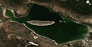
Lake Enriquillo is a hypersaline lake in the Dominican Republic located in the southwestern region of the country. Its waters are shared between the provinces of Bahoruco and Independencia, the latter of which borders Haiti. Lake Enriquillo is the largest lake in both the Dominican Republic and Hispaniola, as well as the entire Caribbean. It is also the lowest point for an island country.

The La Selle thrush is a species of bird in the family Turdidae endemic to the Caribbean island of Hispaniola. A skulker of broadleaf and pine forests around 1300m, it is limited to a small and declining population in the inland Dominican Republic, as well as a relict population in Haiti.

The white-winged warbler, also called the white-winged ground-warbler or Hispaniolan highland-tanager, is a Vulnerable species of bird of the family Phaenicophilidae, the Hispaniolan tanagers. It is endemic to the island of Hispaniola which is shared by Haiti and the Dominican Republic.

The Hispaniolan trogon is a species of bird in the family Trogonidae. It is endemic to Hispaniola in the Caribbean. It is one of the only two trogon species found in the Caribbean. It is the national bird of Haiti.
The Massif de la Hotte is a mountain range in southwestern Haiti, on the Tiburon Peninsula. About 2.5 million years ago, Massif de la Hotte was separated from the Massif de la Selle by a deep, wide sea channel, and formed a separate island. This resulted in a hotbed of endemism in la Hottes bird, plant, and reptile communities. The Massif de la Hotte is subdivided into the Oriental la Hotte in the East, the central la Hotte and the Occidental la Hotte on the Western tip of the Tiburon peninsula. The Occidental la Hotte is relatively remote and is one of the most biologically diverse and significant areas of all of Hispaniola. It also supports some of the last stands of Haiti's dense cloud forest on its peaks.
The Cordillera Septentrional is a mountain range that runs parallel to the north coast of the Dominican Republic, with extensions to the northwest as Tortuga island in Haiti, and to the southeast through lowlands to where it rises as the Sierra de Samaná on the Samaná Peninsula.

The wildlife of Haiti is important to the country because of its biodiversity. According to the World Conservation Monitoring Centre, Haiti is considered to be "one of the most biologically significant countries of the West Indies". With an estimated 5,600 plant species on the island of Hispaniola, some of which only occur in Haiti, 36% are considered as endemic to the island. A mountainous area country, it is situated in the western three-eighths of Hispaniola and shares a border with the Dominican Republic. There are nine life zones, from low desert to high cloud forests, as well as four mountain ranges, and hundreds of rivers and streams and the coral reefs in the seas that surround the islands. Issues of environmental damage, expanding population, deforesting and erosion are of concern; less than 2% of the original forest remains on account of deforestation. This degradation is traced from the 17th century to 19th century starting with the French colonization of the Haiti and population explosion during the 20th century and for the purpose of forestry and sugar-related industries, degraded the forests. and the environment.

José Armando Bermúdez National Park is a Dominican Republic National Park spanning the northern slopes and central portions of the Central Mountain Range.
The Massif du Nord is the longest mountain range of Haiti.

