Corniglio | |
---|---|
Comune | |
Comune di Corniglio | |
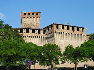
Castle of Corniglio. | |
Coordinates: 44°29′N10°5′E / 44.483°N 10.083°E Coordinates: 44°29′N10°5′E / 44.483°N 10.083°E | |
Country | Italy |
Region | Emilia-Romagna |
Province | Parma (PR) |
Frazioni | Agna, Ballone, Beduzzo, Bellasola, Bosco, Bosco-Centrale, Braia, Ca'Pussini, Canetolo, Casa Martane, Case Pellinghelli, Centrale Idroelettrica, Cirone, Costa, Costa Venturina, Costalbocco, Curatico, Curatico San Rocco, Favet, Grammatica, La Costa, La Villa, Lago, Marra, Miano, Migliarina, Moretta, Mossale, Mossale Inferiore, Mossale Superiore, Mulino Vecchio, Petrignacola di Sopra, Petrignacola di Sotto, Prella, Pugnetolo, Rivalba, Roccaferrara, Sauna, Sesta Inferiore, Sesta Superiore, Signatico, Sivizzo, Staiola, Torre, Tre Rii, Tufi, Vesta, Vestana Inferiore, Vestana Superiore, Vestola-Ghiare, Villula |
Government | |
• Mayor | Giuseppe Delsante |
Area | |
• Total | 165.7 km2 (64.0 sq mi) |
Elevation | 690 m (2,260 ft) |
Population (30 June 2017) [1] | |
• Total | 1,865 |
• Density | 11/km2 (29/sq mi) |
Demonym(s) | Cornigliesi |
Time zone | CET (UTC+1) |
• Summer (DST) | CEST (UTC+2) |
Postal code | 43021 |
Dialing code | 0521 |
Website | Official website |
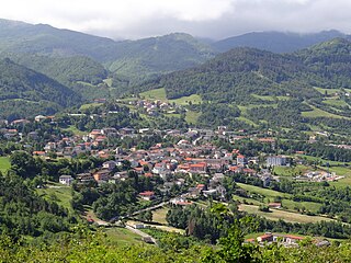
Corniglio (Parmigiano: Cornì) is a comune (municipality) in the Province of Parma in the Italian region Emilia-Romagna, located about 100 kilometres (62 mi) west of Bologna and about 40 kilometres (25 mi) southwest of Parma.
The Parmigiano dialect, sometimes the Parmesan dialect, is a dialect of the Emilian language spoken in the Province of Parma, the western-central portion of the Emilia-Romagna administrative region.
The comune is a basic administrative division in Italy, roughly equivalent to a township or municipality.
The Province of Parma is a province in the Emilia-Romagna region of Italy. Its largest town and capital is the city of Parma.
Corniglio borders the following municipalities: Bagnone, Berceto, Calestano, Filattiera, Langhirano, Monchio delle Corti, Palanzano, Pontremoli, Tizzano Val Parma.
Bagnone is a comune (municipality) in the Province of Massa and Carrara in the Italian region Tuscany, located about 120 kilometres (75 mi) northwest of Florence and about 35 kilometres (22 mi) northwest of Massa in the Lunigiana, facing the Monte Sillara, which has a peak elevation of 1,861 metres (6,106 ft). The communal territory is crossed by the Bagnone torrent, a left affluence of the Magra River.
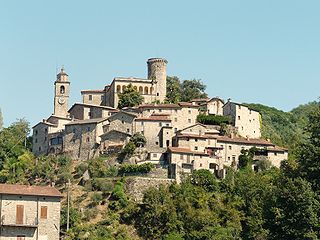
Berceto is a village and comune in Italy, located in the Apennine Mountains on the main road between La Spezia and Parma, in the Taro River valley, in the region of Emilia-Romagna.
Calestano is a comune (municipality) in the Province of Parma in the Italian region Emilia-Romagna, located about 100 kilometres (62 mi) west of Bologna and about 30 kilometres (19 mi) southwest of Parma.
It is home to a castle, known since 1240. It was built in sandstone by the Rossi family, who held it until the 16th century.
Albareto is a comune (municipality) in the Province of Parma in the Italian region Emilia-Romagna, located about 130 kilometres (81 mi) west of Bologna and about 60 kilometres (37 mi) southwest of Parma.
Fontevivo is a comune (municipality) in the Province of Parma in the Italian region Emilia-Romagna, located about 100 kilometres (62 mi) northwest of Bologna and about 14 kilometres (9 mi) northwest of Parma. As of 31 December 2004, it had a population of 5,337 and an area of 25.9 square kilometres (10.0 sq mi).
Langhirano is a comune (municipality) in the Province of Parma in the Italian region Emilia-Romagna, located about 90 kilometres (56 mi) west of Bologna and about 20 kilometres (12 mi) south of Parma.
Lesignano de' Bagni is a comune (municipality) in the Province of Parma in the Italian region Emilia-Romagna, located about 90 kilometres (56 mi) west of Bologna and about 15 kilometres (9 mi) south of Parma.
Medesano is a comune (municipality) in the Province of Parma in the Italian region Emilia-Romagna, located about 100 kilometres (62 mi) northwest of Bologna and about 15 kilometres (9 mi) southwest of Parma. As of 31 May 2007, it had a population of 10,221 and an area of 88.8 square kilometres (34.3 sq mi).
Montechiarugolo is a comune (municipality) in the Province of Parma in the Italian region Emilia-Romagna, located about 80 kilometres (50 mi) northwest of Bologna and about 13 kilometres (8 mi) southeast of Parma.
Noceto is a comune (municipality) in the province of Parma in the Italian region Emilia-Romagna, located about 100 kilometres (62 mi) northwest of Bologna and about 12 kilometres (7 mi) west of Parma.
Palanzano is a comune (municipality) in the Province of Parma in the Italian region Emilia-Romagna, located about 90 kilometres (56 mi) west of Bologna and about 40 kilometres (25 mi) south of Parma. Palanzano borders the following municipalities: Corniglio, Monchio delle Corti, Neviano degli Arduini, Tizzano Val Parma, Ventasso, Vetto.
Pellegrino Parmense is a comune (municipality) in the Province of Parma in the Italian region Emilia-Romagna, located about 120 kilometres (75 mi) west of Bologna and about 35 kilometres (22 mi) west of Parma, in the northern part of the Valle del Ceno.
Sala Baganza is a comune (municipality) in the Province of Parma in the Italian region Emilia-Romagna, located about 90 kilometres (56 mi) northwest of Bologna and about 12 kilometres (7 mi) southwest of Parma.
San Secondo Parmense is a comune (municipality) in the Province of Parma in the Italian region Emilia-Romagna, located about 200 kilometres (120 mi) northwest of Bologna and about 15 kilometres (9 mi) northwest of Parma.
Solignano is a comune (municipality) in the Province of Parma in the Italian region Emilia-Romagna, located about 110 kilometres (68 mi) west of Bologna and about 35 kilometres (22 mi) southwest of Parma.
Sorbolo is a comune (municipality) in the Province of Parma in the Italian region Emilia-Romagna, located about 80 kilometres (50 mi) northwest of Bologna and about 11 kilometres (7 mi) northeast of Parma.
Tizzano Val Parma is a comune (municipality) in the Province of Parma in the Italian region Emilia-Romagna, located about 90 kilometres (56 mi) west of Bologna and about 35 kilometres (22 mi) southwest of Parma.
Tornolo is a comune (municipality) in the Province of Parma in the Italian region Emilia-Romagna, located about 140 kilometres (87 mi) west of Bologna and about 70 kilometres (43 mi) southwest of Parma.
Traversetolo is a comune (municipality) in the Province of Parma in the Italian region Emilia-Romagna, located about 80 kilometres (50 mi) west of Bologna and about 20 kilometres (12 mi) south of Parma.
Valmozzola is a comune (municipality) in the Province of Parma in the Italian region Emilia-Romagna, located about 120 kilometres (75 mi) west of Bologna and about 45 kilometres (28 mi) southwest of Parma.
Varano de' Melegari is a comune (municipality) in the Province of Parma in the Italian region Emilia-Romagna, located about 110 kilometres (68 mi) west of Bologna and about 30 kilometres (19 mi) southwest of Parma.
Varsi is a comune (municipality) in the Province of Parma in the Italian region Emilia-Romagna, located about 120 kilometres (75 mi) west of Bologna and about 40 kilometres (25 mi) southwest of Parma.
This article on a location in Emilia–Romagna is a stub. You can help Wikipedia by expanding it. |