
Noe Valley is a neighborhood in the central part of San Francisco, California. It is named for Don José de Jesús Noé, noted 19th-century Californio statesman and ranchero, who owned much of the area and served as mayor.

Buena Vista Park is a park in the Haight-Ashbury and Buena Vista Heights neighborhoods of San Francisco, California. It is the oldest official park in San Francisco, established in 1867 as Hill Park, later renamed Buena Vista. It is bounded by Haight Street to the north, and by Buena Vista Avenue West and Buena Vista Avenue East. The park is on a steep hill that peaks at 575 feet (175 m), and covers 37 acres (150,000 m2). The lowest section is the north end along Haight.

The Duboce Triangle is a neighborhood of San Francisco, California, located below Buena Vista Park and between the neighborhoods of the Castro/Eureka Valley, the Mission District, and the Lower Haight.
Cole Valley is a small neighborhood in San Francisco, California. It borders Golden Gate Park to the north, Haight-Ashbury to the northeast, The Castro to the east. and Twin Peaks to the south. Near Kezar Stadium, Cole Valley is the smallest neighborhood in the city.
Eureka Valley is a neighborhood in San Francisco, primarily a quiet residential neighborhood but boasting one of the most visited sub-neighborhoods in the city, The Castro.

Pacific Heights is a neighborhood in San Francisco, California. It has panoramic views of the Golden Gate Bridge, San Francisco Bay, the Palace of Fine Arts, Alcatraz, and the Presidio.

Diamond Heights is a neighborhood in central San Francisco, California, roughly bordered by Diamond Heights Boulevard and Noe Valley to the north and east and Glen Canyon Park to the south and west. It is built on three hills: Red Rock Heights on the northwest, Gold Mine Hill in center, and Fairmount Heights on the southeast.

The Randall Museum is a museum in central San Francisco, California, owned and operated by the San Francisco Recreation & Parks Department with the support of the Randall Friends. The museum focuses on science, nature and the arts. On exhibit are live native and domestic animals and interactive displays about nature. Other facilities include a theater, a wood shop, and art and ceramics studios.
La Loma Park is a tract of land located in the Berkeley Hills section of the city of Berkeley, California in the San Francisco Bay Area. The Spanish word loma means "rise/low hill". It was the property of Captain Richard Parks Thomas, a veteran of the Civil War and Berkeley businessman. Today, it is entirely a residential area. Although hilly throughout, its average elevation is about 614 feet (187 m).

Telegraph Hill is a hill and surrounding neighborhood in San Francisco, California. It is one of San Francisco's 44 hills, and one of its original "Seven Hills".
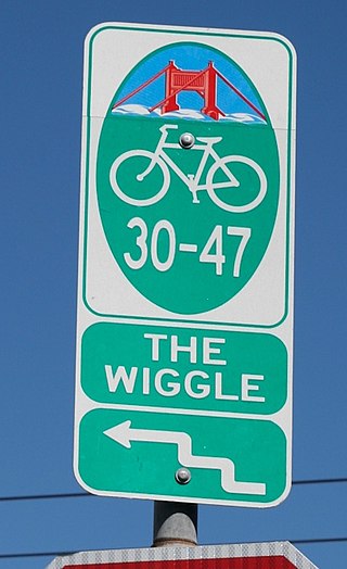
The Wiggle is a 1-mile (1.6 km) zig-zagging bicycle route from Market Street to Golden Gate Park in San Francisco, California, that minimizes hilly inclines for bicycle riders. Rising 120 feet (37 m), The Wiggle inclines average 3% and never exceed 6%. The path generally follows the historical route of the long since paved-over Sans Souci Valley watercourse, winding through the Lower Haight neighborhood toward the Panhandle section of Golden Gate Park.

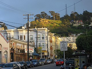
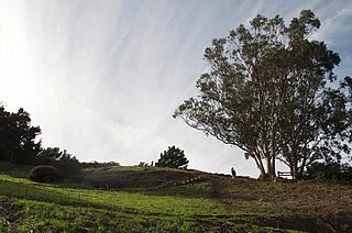
Corona Heights Park is a park in the Castro and Corona Heights neighborhoods of San Francisco, California, United States. It is situated immediately to the south of Buena Vista Park. Corona Heights is bounded in part by Flint Street on the east, Roosevelt Way to the north, and 16th Street to the south. The base of the hill is at approximately 300 feet (91 m), while the peak extends to 520 feet (160 m) above sea level.

Polk Street is a street in San Francisco, California, that travels northward from Market Street to Beach Street and is one of the main thoroughfares of the Polk Gulch neighborhood traversing through the Tenderloin, Nob Hill, and Russian Hill neighborhoods. The street takes its name from former U.S. President James K. Polk.

The 2002 San Francisco Board of Supervisors elections occurred on November 5, 2002, with runoff elections held on December 10, 2002. Five of the eleven seats were contested in this election. Three incumbents ran for reelection, while two sought another office.

The Pink Triangle Park is a triangle-shaped mini-park located in the Castro District of San Francisco, California. The park is less than 4,000 square feet (370 m2) and faces Market Street with 17th Street to its back. The park sits directly above the Castro Street Station of Muni Metro, across from Harvey Milk Plaza. It is the first permanent, free-standing memorial in America dedicated to the thousands of persecuted homosexuals in Nazi Germany during the Holocaust of World War II.

The Castro District, commonly referred to as the Castro, is a neighborhood in Eureka Valley in San Francisco. The Castro was one of the first gay neighborhoods in the United States. Having transformed from a working-class neighborhood through the 1960s and 1970s, the Castro remains one of the most prominent symbols of lesbian, gay, bisexual, and transgender (LGBT) activism and events in the world.
The 2014 San Francisco Board of Supervisors elections occurred on November 4, 2014. Five of the eleven seats of the San Francisco Board of Supervisors were contested in this election. Incumbents in all five districts successfully ran for re-election.
Billy Goat Hill, San Francisco is the easternmost peak in the San Miguel Range located in the Glen Park neighborhood in San Francisco, California.
 Corona Heights.
 Excavation begins for the Gray Brother's Quarry in 1899.
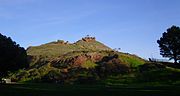 Corona Heights Park.


