Corryton, Tennessee

Last updated

Corryton, Tennessee
Corryton Village
Corryton-intersection-tn2.jpg
Corryton Depot near the intersection of Corryton Road and Corryton Luttrell Road
USA Tennessee location map.svg
Red pog.svg
Corryton
Location in Tennessee and the United States
Usa edcp location map.svg
Red pog.svg
Corryton
Corryton (the United States)
Coordinates: 36°09′13″N83°46′57″W / 36.15361°N 83.78250°W / 36.15361; -83.78250
Country United States
State Tennessee
County Knox
Settled1785
Founded byJohn Sawyers
Named for Corryton Woodbury [1]
Government
[2]
  Type County Commission
  CommissionerRichie Beeler (District 8)
Elevation
[3]
1,043 ft (318 m)
Time zone UTC-5 (Eastern (EST))
  Summer (DST) UTC-4 (EDT)
ZIP codes
37721
Area code 865
FIPS code 47093
GNIS feature ID1281332 [3]

Corryton, also known as Corryton Village, [4] is an unincorporated bedroom community [5] in northeastern Knox County, Tennessee, United States, about 15 miles northeast of Knoxville. The United States Geographic Names System classifies Corryton as a populated place. [3] It is included in Knoxville Metropolitan Statistical Area.

Contents

Geography

Corryton is situated near two mountains, House Mountain (the highest point in Knox County) [6] and Clinch Mountain. It includes two elementary schools, a middle school, a high school, a public library, community center, and several churches including Little Flat Creek Baptist Church (founded in 1797, making it the first Baptist church organized in Knox County), Corryton Church (formerly Corryton Baptist) and Rutherford Memorial United Methodist.

History

John Sawyers, a Revolutionary War veteran, settled in the vicinity of what is now Corryton in 1785. He subsequently built a small fort along the Emory Road. The community remained primarily agricultural until the construction of the Knoxville, Cumberland Gap and Louisville Railroad through the area in the late 1880s. The rail station that served the community was initially known as "Floyd." [7]

In 1887, a developer named Corryton Woodbury purchased property surrounding the rail depot to grow the community into a suburban town. [8] The lots failed to sell, and the venture was unsuccessful, with the community remaining a predominantly rural hamlet. [9]

On April 25, 1983, Thomas Knauff set an FAI world record flying a glider on an out-and-return course of 1,646.68 km (1,023.20 mi), releasing from tow over Williamsport Regional Airport in Pennsylvania, flying south along the Ridge-and-valley Appalachians to take a turn-point photograph of the Little Flat Creek Church in Corryton, then returning for a landing after a 10-hour flight. The photographs were published in National Geographic magazine.[ citation needed ] This world record stood until 2003 when it was broken in Argentina, but still stands as a U.S. national record. [10]

Notable people

Related Research Articles

<span class="mw-page-title-main">Knox County, Tennessee</span> County in Tennessee, United States

Knox County is located in the U.S. state of Tennessee. As of the 2020 census, the population was 478,971, making it the third-most populous county in Tennessee. Its county seat is Knoxville, which is the third-most populous city in Tennessee. Knox County is included in the Knoxville metropolitan area. The county is located at the geographical center of the Great Valley of East Tennessee. Near the heart of the county is the origin of the Tennessee River, at the confluence of the Holston and French Broad rivers.

<span class="mw-page-title-main">Grainger County, Tennessee</span> County in Tennessee, United States

Grainger County is a county located in the U.S. state of Tennessee. As of the 2020 census, the population was 23,527. Its county seat is Rutledge. Grainger County is a part of both the Knoxville Metropolitan Statistical Area and Morristown Metropolitan Statistical Area.

<span class="mw-page-title-main">Blaine, Tennessee</span> Knoxville suburb and city in Grainger County, Tennessee

Blaine, formerly known as Blaine's Crossroads, is a city in Grainger County, Tennessee, United States, and a suburb of neighboring Knoxville. It is part of both the Knoxville Metropolitan Statistical Area and the Morristown Metropolitan Statistical Area. The population was 2,084 at the 2020 census.

<span class="mw-page-title-main">Knoxville, Tennessee</span> City in Tennessee, United States

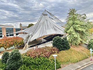
Knoxville is a city in and the county seat of Knox County, Tennessee, United States. As of the 2020 United States census, Knoxville's population was 190,740, making it the largest city in the East Tennessee Grand Division and the state's third-most-populous city after Nashville and Memphis. It is the principal city of the Knoxville metropolitan area, which had a population of 879,773 in 2020.

<span class="mw-page-title-main">Sevierville, Tennessee</span> City in Tennessee, United States

Sevierville is a city in and the county seat of Sevier County, Tennessee, United States, located in eastern Tennessee. The population was 17,889 at the 2020 United States Census.

<span class="mw-page-title-main">Seymour, Tennessee</span> CDP in Tennessee, United States

Seymour is a census-designated place (CDP) and unincorporated community in Blount and Sevier counties in the U.S. state of Tennessee. The CDP population was 14,705 at the 2020 U.S. census. It is included in the Knoxville, Tennessee Metropolitan Statistical Area.

<span class="mw-page-title-main">Halls Crossroads, Tennessee</span> CDP in Tennessee, United States

Halls Crossroads is a census-designated place in northern Knox County, Tennessee. As a northern suburb of nearby Knoxville, Halls is included in the Knoxville Metropolitan Statistical Area. The town takes its name from the Thomas Hall family that settled in the area in the late 18th century.

<span class="mw-page-title-main">Cades Cove</span> Valley within the Great Smoky Mountains

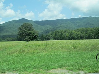
Cades Cove is an isolated valley located in the Tennessee section of the Great Smoky Mountains National Park. The valley was home to numerous settlers before the formation of the national park. Cades Cove, the single most popular destination for visitors to the park, attracts more than two million visitors annually because of its well preserved homesteads, scenic mountain views, and abundant display of wildlife. The Cades Cove Historic District is listed on the National Register of Historic Places.

<span class="mw-page-title-main">Powell, Tennessee</span> CDP in Tennessee, United States

Powell, formerly known as Powell Station, is a census-designated place in Knox County, Tennessee. The area is located in the Emory Road corridor, just north of Knoxville, southeast of Clinton, and east of Oak Ridge. It had a population of 13,802 during the 2020 census. It is included in the Knoxville, TN Metropolitan Statistical Area.

<span class="mw-page-title-main">Fountain City, Knoxville</span> Neighborhood in Knoxville, Tennessee

Fountain City is a neighborhood in northern Knoxville, Tennessee, in the southeastern United States. Although not a census-designated place, the populations of the two ZIP codes that serve Fountain City— 37918 and 37912— were 36,815 and 18,695, respectively, as of the 2000 U.S. census. At the time of its annexation by the city of Knoxville in 1962, Fountain City was the largest unincorporated community in the United States.

<span class="mw-page-title-main">U.S. Route 11W</span> Suffixed section of U.S. Highway in Tennessee and Virginia in the United States

U.S. Route 11W (US 11W) is the western branch of US 11 from the twin cities of Bristol, Tennessee/Bristol, Virginia, where US 11 splits into US 11E and US 11W, to Knoxville, Tennessee, where the two highways rejoin. The highway serves the Appalachia region's Ridge-and-Valley section of East Tennessee, bounded by the Clinch Mountain ridge to the north and the Holston River to the south. US 11W from Bristol to Bean Station and Blaine to Knoxville are designated as part of the National Highway System.

<span class="mw-page-title-main">Karns, Tennessee</span> CDP in Tennessee, United States

Karns is an unincorporated community and census-designated place in northwest Knox County, Tennessee, about 11 miles (18 km) northwest of the center of Knoxville. The population of the CDP was 3,536 at the 2020 census.

Bearden High School is a Knox County, Tennessee, high school located in the Bearden area in the city of Knoxville.

<span class="mw-page-title-main">House Mountain (Knox County, Tennessee)</span> Mountain in the U.S. state of Tennessee

House Mountain is a mountain located in Corryton, Tennessee, United States, about 8 miles (13 km) northeast of Knoxville. Rising to an elevation of 2,064 feet (629 m) above sea level, House Mountain is the highest point in Knox County.

<span class="mw-page-title-main">Tennessee State Route 131</span> State highway in Tennessee, United States

State Route 131 is a south-to-north highway in the U.S. state of Tennessee that is 68.8 miles long. It is designated as a secondary route.

<span class="mw-page-title-main">Knox County Schools</span> School district in Tennessee, United States

Knox County Schools is the school district that operates all public schools in Knox County, Tennessee.

<span class="mw-page-title-main">Great Smoky Mountain Council</span>

The Great Smoky Mountain Council is a local council of the Boy Scouts of America in Tennessee, with headquarters in Knoxville. It serves 21 East Tennessee counties that span two time zones. Camp Buck Toms is a summer camp owned and operated by the Great Smoky Mountain Council. The camp is located outside Rockwood, Tennessee, on the shores of Watts Bar Lake.

<span class="mw-page-title-main">Harbison Crossroads, Tennessee</span> Unincorporated community in Tennessee, United States

Harbison Crossroads is an unincorporated community of Knox County, Tennessee, United States, located approximately 10 miles Northeast of Knoxville. It is also referred by the unofficial name of Gibbs.

<span class="mw-page-title-main">Dave Wright (politician)</span> American politician (born 1945)

Dave Wright is an American politician who currently serves as a member of the Tennessee House of Representatives. A Republican, Wright is based in Corryton, an unincorporated community in Knox County, and represents the District 19, which consists of the northeastern parts of Knox County.

References

  1. Miller, Larry (2001). Tennessee Place Names. Indiana University Press. p. 51. ISBN   0-253-33984-7 . Retrieved July 25, 2020.
  2. "Commissioners". Knox County, Tennessee . Retrieved January 12, 2021.
  3. 1 2 3 U.S. Geological Survey Geographic Names Information System: Corryton, Tennessee
  4. "2015 Northeast County Sector Plan" (PDF). Knoxville-Knox County Metropolitan Planning Commission. December 10, 2015. Retrieved January 12, 2021.
  5. West, Carroll Van (1995). Tennessee's Historic Landscapes: A Traveler's Guide. University of Tennessee Press. pp. 166–167. ISBN   9780870498817.
  6. Tom Dunigan (December 8, 2013). "Tennessee county high points". Tnlandforms.us. Retrieved June 23, 2016.
  7. Steely, Mike (April 16, 2017). "How Knox County places were named". The Knoxville Focus. Retrieved January 13, 2021.
  8. Mayshark, Jesse (July 25, 2019). "Precinct Profile: Knox County #80". Knoxville Compass. Retrieved January 14, 2021.
  9. Rothrock, Mary (1972). The French Broad-Holston Country A History of Knox County, Tennessee. East Tennessee Historical Society. pp. 349–350. Retrieved January 14, 2021.
  10. Gliding World Records ID 5427 Archived June 11, 2007, at archive.today , Fédération Aéronautique Internationale