Fuerteventura is one of the Canary Islands, in the Atlantic Ocean, part of the North Africa region, and politically part of Spain. It is located 97 km (60 mi) away from the northwestern coast of Africa. The island was declared a biosphere reserve by UNESCO in 2009.

Lanzarote is a Spanish island, the easternmost of the Canary Islands in the Atlantic Ocean. It is located approximately 125 kilometres off the north coast of Africa and 1,000 kilometres from the Iberian Peninsula. Covering 845.94 square kilometres, Lanzarote is the fourth-largest of the islands in the archipelago. With 152,289 inhabitants at the start of 2019, it is the third most populous Canary Island, after Tenerife and Gran Canaria. Located in the centre-west of the island is Timanfaya National Park, one of its main attractions. The island was declared a biosphere reserve by UNESCO in 1993. The island's capital is Arrecife, which lies on the eastern coastline. It is the smaller main island of the Province of Las Palmas.

Yaiza is a municipality on the island of Lanzarote in the Canary Islands, Spain. It lies in the southwest of the island and forms part of the province of Las Palmas. The municipality is bounded by the Atlantic Ocean to the west, south and east. To the north, the Timanfaya National Park is partly within the municipality. The eastern part of the municipality is mountainous and, south west of the mountains, the Rubicon plain stretches to the coast.

Arrecife is the capital city and a municipality of Lanzarote in the Canary Islands. It was made the island's capital in 1852. The city owes its name to the rock reef which covers its local beach. It also gives its name to the nearby Arrecife Airport. The population of the municipality was 64,645 in 2020. Its area is 22.72 square kilometres (8.77 sq mi).

Puerto del Carmen is the main tourist town on the island of Lanzarote, Canary Islands, Spain. It is part of the municipality of Tías. Most of Lanzarote's over 1 million visitors per year choose this town as their destination. As a result, almost all of the town's economy revolves around tourism.

San Bartolomé is a town and municipality in the Canary Islands (Spain) situated in the centre of the island of Lanzarote. The municipality of San Bartolomé stretches to the southeastern coast of the island.

Graciosa Island or commonly La Graciosa is a volcanic island in the Canary Islands of Spain, located two kilometres north of Lanzarote across the Strait of El Río. It was formed by the Canary hotspot. The island is part of the Chinijo Archipelago and the Chinijo Archipelago Natural Park. It is administrated by the municipality of Teguise in the neighboring island of Lanzarote. In 2018 La Graciosa officially became the eighth Canary Island with few real effects. Before then, the island had the status of an islet, administratively dependent on the island of Lanzarote. The only two settlements on the island are Caleta de Sebo in the southeastern part of the island and summer-residence Casas de Pedro Barba.
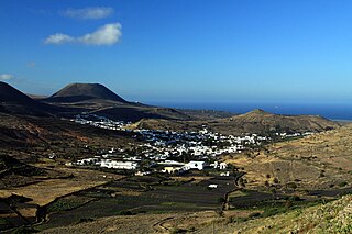
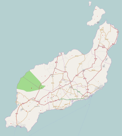
Haría is a municipality on the island of Lanzarote in the Canary Islands, the northernmost and easternmost Canarian municipality. Surrounded on three sides by the Atlantic Ocean, the municipality is bordered to the south by the municipality of Teguise. It forms part of Las Palmas Province. The seat of the municipality is the town of Haría. The population of the municipality was 4,872 in 2013. The total land area of the municipality is 106.59 square kilometres (41.15 sq mi).

Teguise is a municipality in the central part of the island of Lanzarote in the Las Palmas province in the Canary Islands. The population is 22,342, and the area is 263.98 km2. It is located north of Arrecife and south of Haría. The seat of the municipality is the town of Teguise. The municipality also comprises a number of neighbouring islands including Graciosa, Alegranza, Roque del Este, Roque del Oeste and Montaña Clara.

Teguise, also known in Spanish as La Villa de Teguise, is a village in the municipality of Teguise in the north-central part of the island of Lanzarote in Las Palmas province in the Canary Islands. The town's population is 1,776 as of 1 January 2018.

César Manrique Cabrera was a Spanish artist, sculptor, architect and nature activist from Lanzarote.

Maspalomas is a tourist resort in the south of the island of Gran Canaria, Canary Islands, stretching from Bahía Feliz in the east to Meloneras in the west, including the resort towns of San Agustín and Playa del Inglés and San Fernando. Maspalomas constitutes the southernmost part of the municipality of San Bartolomé de Tirajana, and of the island.
Unión Deportiva Lanzarote is a Spanish football team based in Arrecife, Lanzarote, in the autonomous community of Canary Islands. Founded in 1970 it plays in Tercera División RFEF – Group 12, holding home games at the Ciudad Deportiva de Lanzarote, a 6,000-seat stadium which is shared with CD Orientación Marítima.

El Médano is a town in the municipality of Granadilla de Abona, on the island of Tenerife, one of the Canary Islands. It is located about 11 kilometers from the town of Granadilla, reaching an average altitude of 75 meters above sea level.
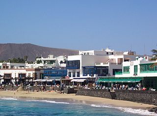
Playa Blanca is the southernmost town of the Spanish island of Lanzarote. It is the newest resort on the island, and is part of the municipality of Yaiza.

Charco del Palo is a naturist holiday village on the north-eastern coast of Lanzarote, in the Canary Islands. The village was established around 1970 by the German entrepreneur Gregor Kaiser. In due course, it has developed into a popular naturist resort. It was the first official naturist resort established in the Canaries: nudity is permitted everywhere in the village, and practised universally. Its isolated location, at the end of a dedicated three kilometer long access road, helps to achieve privacy, while the village remains open to all. Visitors are mainly German, British, and Dutch. The village's population increased from 82 in the year 2000 to 229 in 2011, it has subsequently declined to 156 in 2013.
Playa de la Cocina is a beach on La Graciosa island, part of the municipality of Teguise in Lanzarote, Spain. It is situated near the southwestern point of the island, in a little bay at the foot of the Montaña Amarilla. It is a 10 minutes walk from Playa Francesa in the southwest of the Caleta de Sebo village. The beach's average width is 10 meters and length is 100 metres.
The Lanzarote Independents Party, formerly the Lanzarote Independents Group, is a political party in Lanzarote.
Famara is the main mountainous massif in the north of the island of Lanzarote in the Canary Islands. It is the eastern slope of a volcano erupting in the Miocene. The cliffs of Famara are the remains of a caldera of about ten kilometres in diameter centred on the south of La Graciosa.