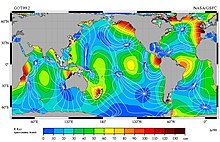
Cotidal lines are the set of places where high tide occurs at the same time.
They sometimes all meet at a particular point called the amphidromic point, where the amplitude of the tide is almost null. [1] [2]
Cotidal lines are the set of places where high tide occurs at the same time.
They sometimes all meet at a particular point called the amphidromic point, where the amplitude of the tide is almost null. [1] [2]

The North Sea lies between Great Britain, Denmark, Norway, Germany, the Netherlands, Belgium and France. An epeiric sea on the European continental shelf, it connects to the Atlantic Ocean through the English Channel in the south and the Norwegian Sea in the north. It is more than 970 kilometres (600 mi) long and 580 kilometres (360 mi) wide, covering 570,000 square kilometres (220,000 sq mi).

Tides are the rise and fall of sea levels caused by the combined effects of the gravitational forces exerted by the Moon and are also caused by the Earth and Moon orbiting one another.

The tidal force or tide-generating force is a gravitational effect that stretches a body along the line towards and away from the center of mass of another body due to spatial variations in strength in gravitational field from the other body. It is responsible for the tides and related phenomena, including solid-earth tides, tidal locking, breaking apart of celestial bodies and formation of ring systems within the Roche limit, and in extreme cases, spaghettification of objects. It arises because the gravitational field exerted on one body by another is not constant across its parts: the nearer side is attracted more strongly than the farther side. The difference is positive in the near side and negative in the far side, which causes a body to get stretched. Thus, the tidal force is also known as the differential force, residual force, or secondary effect of the gravitational field.
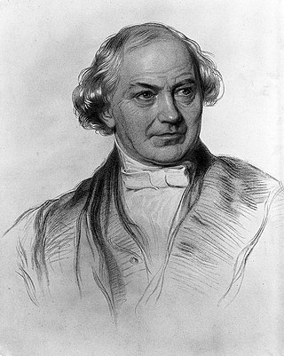
William Whewell was an English polymath, scientist, Anglican priest, philosopher, theologian, and historian of science. He was Master at Trinity College, Cambridge. In his time as a student there, he achieved distinction in both poetry and mathematics.

An amphidromic point, also called a tidal node, is a geographical location which has zero tidal amplitude for one harmonic constituent of the tide. The tidal range for that harmonic constituent increases with distance from this point, though not uniformly. As such, the concept of amphidromic points is crucial to understanding tidal behaviour. The term derives from the Greek words amphi ("around") and dromos ("running"), referring to the rotary tides which circulate around amphidromic points. It was first discovered by William Whewell, who extrapolated the cotidal lines from the coast of the North Sea and found that the lines must meet at some point.

Sir John William Lubbock, 3rd Baronet, FRS, was an English banker, barrister, mathematician and astronomer.

Within the atmospheric sciences, atmospheric physics is the application of physics to the study of the atmosphere. Atmospheric physicists attempt to model Earth's atmosphere and the atmospheres of the other planets using fluid flow equations, radiation budget, and energy transfer processes in the atmosphere. In order to model weather systems, atmospheric physicists employ elements of scattering theory, wave propagation models, cloud physics, statistical mechanics and spatial statistics which are highly mathematical and related to physics. It has close links to meteorology and climatology and also covers the design and construction of instruments for studying the atmosphere and the interpretation of the data they provide, including remote sensing instruments. At the dawn of the space age and the introduction of sounding rockets, aeronomy became a subdiscipline concerning the upper layers of the atmosphere, where dissociation and ionization are important.
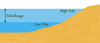
Tidal range is the difference in height between high tide and low tide. Tides are the rise and fall of sea levels caused by gravitational forces exerted by the Moon and Sun, by Earth's rotation and by centrifugal force caused by Earth's progression around the Earth-Moon barycenter. Tidal range depends on time and location.

Head of tide, tidal limit or tidehead is the farthest point upstream where a river is affected by tidal fluctuations, or where the fluctuations are less than a certain amount. The river section influenced by tides and marine forces but without salinity is a tidal river, while downstream areas are brackish and termed estuaries.

Cape Perpetua is a large forested headland projecting into the Pacific Ocean on the central Oregon Coast in Lincoln County, Oregon. The land is managed by the United States Forest Service as part of the Siuslaw National Forest.
The 1972 Orange Bowl was the 38th edition of the college football bowl game, played at the Orange Bowl in Miami, Florida, on Saturday, January 1. The final game of the 1971–72 bowl season, it matched the top-ranked Nebraska Cornhuskers of the Big Eight Conference and the #2 Alabama Crimson Tide of the Southeastern Conference (SEC). This was a rematch of the 1966 Orange Bowl, where Alabama defeated Nebraska to win the national championship. Both teams were undefeated; Nebraska, the defending national champion, built a large lead in the first half and won 38–6.
Internal tides are generated as the surface tides move stratified water up and down sloping topography, which produces a wave in the ocean interior. So internal tides are internal waves at a tidal frequency. The other major source of internal waves is the wind which produces internal waves near the inertial frequency. When a small water parcel is displaced from its equilibrium position, it will return either downwards due to gravity or upwards due to buoyancy. The water parcel will overshoot its original equilibrium position and this disturbance will set off an internal gravity wave. Munk (1981) notes, "Gravity waves in the ocean's interior are as common as waves at the sea surface-perhaps even more so, for no one has ever reported an interior calm."
Point Reyes State Marine Reserve (SMR) and Point Reyes State Marine Conservation Area (SMCA) are two adjoining marine protected areas that extend offshore of Point Reyes Headlands and within Drakes Bay in Marin County on California’s north central coast. The combined area of these marine protected areas is 21.49 square miles, with 9.38 in the SMR, and 12.11 in the adjacent SMCA. Point Reyes SMR prohibits the take of all living marine resources. Point Reyes SMCA prohibits the take of all living marine resources, except the recreational and commercial take of Dungeness crab by pot and salmon by trolling.

The December 1992 nor'easter produced record high tides and snowfall across the northeastern United States. It developed as a low pressure area on December 10 over Virginia, and for two days it remained over the Mid-Atlantic states before moving offshore. In Maryland, the snowfall unofficially reached 48 in (1,200 mm); if verified, the total would have been the highest in the state's history. About 120,000 people were left without power in the state due to high winds. Along the Maryland coast, the storm was less severe than the Perfect Storm in the previous year, although the strongest portion of the storm remained over New Jersey for several days. In the state, winds reached 80 mph (130 km/h) in Cape May, and tides peaked at 10.4 ft (3.2 m) in Perth Amboy. The combination of high tides and 25 ft (7.6 m) waves caused the most significant flooding in the state since the Ash Wednesday Storm of 1962. Several highways and portions of the New York City Subway and Port Authority Trans-Hudson systems were closed due to the storm. Throughout New Jersey, the nor'easter damaged about 3,200 homes and caused an estimated $750 million in damage (1992 USD).

The January 1992 nor'easter was the second in a series of nor'easters in a 14-month period that produced strong winds, high tides, and flooding along the East Coast of the United States. It was a small, short-lived storm that was poorly forecast, intensifying rapidly on January 4 before striking the Eastern Shore of Virginia. The strongest quadrant of the storm moved over Delaware, and winds in the state reached 58 mph (93 km/h). The nor'easter weakened as it moved westward, and it dissipated over Virginia before the energy reformed and redeveloped offshore.

Crystal Cove State Marine Conservation Area (SMCA) is one of a cluster of four adjoining marine protected areas that extend offshore of Newport Beach in Orange County on California’s south coast. The SMCA covers 3.45 square miles of near shore waters. Crystal Cove protects marine life by limiting the removal of marine wildlife from within its borders, including tide pools. Take of all living marine resources is prohibited except: recreational take of finfish by hook-and-line or by spearfishing, and lobster and sea urchin is allowed. Commercial take of coastal pelagic species by round haul net, spiny lobster by trap, and sea urchin is allowed.

Weeroona Island is a 77 ha island in the Australian state of South Australia located in Germein Bay, Spencer Gulf between the city of Port Pirie and town of Port Germein. It features the wreck of the York, coastal shacks, sandy beaches and is connected with the mainland by a 300m long causeway spanning mangroves and tidal flats.
The 2016 Alabama Crimson Tide football team represented the University of Alabama in the 2016 NCAA Division I FBS football season. This season marked the Crimson Tide's 122nd overall season, 83rd as a member of the Southeastern Conference (SEC) and its 25th within the SEC Western Division. They played their home games at Bryant–Denny Stadium in Tuscaloosa, Alabama and were led by tenth year head coach Nick Saban. They finished the season 14–1, were SEC champions and advanced to the College Football Playoff National Championship game, for the second consecutive year, where they were defeated by Clemson.
Harry A. Marmer was a Russian Empire-born American engineer, mathematician and oceanographer who was a career employee of the United States Coast and Geodetic Survey. He was an internationally recognized expert on tides and currents.
Time and Tide Bell is an art project made up of bells, designed by UK sculptor Marcus Vergette and Australian bell designer Neil McLachlan, installed at coastal locations in the UK. The first one was placed at Appledore, Devon, in 2009 and the seventh at Mablethorpe, Lincolnshire in June 2019. As of 2021 at least six further bells are planned, and funding obtained from the National Lottery Heritage Fund in 2018 will allow for up to sixteen bells in all to be installed.
| | This oceanography article is a stub. You can help Wikipedia by expanding it. |