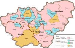
South Yorkshire is a ceremonial and metropolitan county in the Yorkshire and Humber Region of England. The county has four council areas which are the cities of Doncaster and Sheffield as well as the boroughs of Barnsley and Rotherham.

The West Riding of Yorkshire is one of three historic subdivisions of Yorkshire, England. From 1889 to 1974 the administrative county County of York, West Riding, abbreviated County of York (WR), was based closely on the historic boundaries. The lieutenancy at that time included the City of York and as such was named West Riding of the County of York and the County of the City of York.

Barnsley is a market town in South Yorkshire, England. It is the main settlement of the Metropolitan Borough of Barnsley and the fourth largest settlement in South Yorkshire. The town's population was 96,888 in 2021, while the wider borough had a population of 244,600 in the 2021 census.

The North Riding of Yorkshire is a subdivision of Yorkshire, England, alongside York, the East Riding and West Riding. The riding's highest point is at Mickle Fell with 2,585 ft (788 metres).

Penistone is a market town and civil parish in the Metropolitan Borough of Barnsley, South Yorkshire, England, which had a population of 22,909 at the 2011 census. Historically in the West Riding of Yorkshire, it is 8 miles (13 km) west of Barnsley, 17 miles (27 km) north-east of Glossop, 14.2 miles (23 km) north-west of Sheffield, 27 miles (43 km) south-west of Leeds and 29 miles (47 km) east of Manchester in the foothills of the Pennines. The town is frequently noted on lists of unusual place names.

The Borough of Scarborough is a non-metropolitan district and borough of North Yorkshire, England. In addition to the town of Scarborough, it covers a large stretch of the coast of Yorkshire, including Whitby and Filey. It borders Redcar and Cleveland to the north, the Ryedale and Hambleton districts to the west and the East Riding of Yorkshire to the south.
The City of Sheffield is a city and metropolitan borough in South Yorkshire, England. The metropolitan borough includes the administrative centre of Sheffield, the town of Stocksbridge and larger village of Chapeltown and part of the Peak District. It has a population of 584,853, making it technically the third largest city in England by population behind Birmingham and Leeds, since London is not considered a single entity. It is governed by Sheffield City Council.
The Metropolitan Borough of Barnsley is a metropolitan borough in South Yorkshire, England; the main settlement is Barnsley and other notable towns include Penistone, Wombwell and Hoyland.

Staincross is a village in South Yorkshire, England, on the border with West Yorkshire. Historically part of the West Riding of Yorkshire, it formed part of the defunct Barnsley West and Penistone borough constituency, following the Boundary Commission for England's report on South Yorkshire's Parliamentary constituencies in 2004 and the subsequent inquiry in 2005, it is now part of the Barnsley Central borough constituency. The population now falls within the Darton East ward of the Metropolitan Borough of Barnsley. The village also gave its name to the Staincross wapentake in the West Riding of Yorkshire. It is situated about 3 miles (4.8 km) from Barnsley, and 8 miles (13 km) from Wakefield.

Cudworth is an urban village approximately 3.5 miles (5.6 km) north-east of Barnsley transport interchange in South Yorkshire, England. Historically within the West Riding of Yorkshire, Cudworth has a busy shopping area along the Barnsley to Pontefract Road which serves a local population of 10,977.

Penistone and Stocksbridge is a constituency in the House of Commons of the UK Parliament represented since 2019 by Miriam Cates, a Conservative. As with all constituencies, adults qualifying to vote in the seat elect one Member of Parliament (MP) by the first past the post system of election at least every five years.
Penistone Rural District was a rural district in the West Riding of Yorkshire. It was named after but did not contain Penistone. The town itself was contained within the Penistone Urban District.
The Local Government Commission for England was established by the Local Government Act 1958 to review the organisation of local government, and make "such proposals as are hereinafter authorised for effecting changes appearing to the Commissions desirable in the interests of effective and convenient local government". Most of the commission's proposals failed to reach consensus and were not implemented, and the body was dissolved in 1967.
The Local Government Boundary Commission was established in 1945 to review the boundaries of local authority areas in England and Wales outside the Counties of London and Middlesex. The Commission produced its report in 1948 which proposed large changes to county-level areas of local government and changes in the structure and division of powers between tiers of administration. The Commission's proposals were not acted on, and it was disbanded in 1949.
The history of local government in Yorkshire is unique and complex. Yorkshire is the largest historic English county and consists of a diverse mix of urban and rural development with a heritage in agriculture, manufacturing, and mining. After a long period with little change, it has been subject to a number of reforms of local government structures in modern times, some of which were controversial. The most significant of these were the Local Government Act 1972, the 1990s UK local government reform, and the Localism Act 2011. The historic area currently corresponds to several counties and districts and is mostly contained within the Yorkshire and the Humber region.
The Sheriff of Hallamshire was a shrievalty title which was in existence from 1962 until 1974 in Yorkshire, United Kingdom.
Barnsley was a rural district in the West Riding of Yorkshire, England from 1894 to 1938. It encompassed the surrounding area but did not include the town of Barnsley.
The East Riding of Yorkshire is a local government district with unitary authority status, and is a ceremonial county of England. It is named after the historic East Riding of Yorkshire which was one of three ridings alongside the North Riding and West Riding, which were constituent parts a Yorkshire ceremonial and administrative county until 1974. From 1974 to 1996 the area of the modern East Riding of Yorkshire constituted the northern part of Humberside.
 Map of boundary as of 1971