Cowpens, South Carolina

Last updated

Cowpens, South Carolina
SCMap-doton-Cowpens.PNG
Location of Cowpens, South Carolina
Coordinates: 35°0′58″N81°48′15″W / 35.01611°N 81.80417°W / 35.01611; -81.80417
Country United States
State South Carolina
County Spartanburg
Area
[1]
  Total2.29 sq mi (5.94 km2)
  Land2.29 sq mi (5.94 km2)
  Water0.00 sq mi (0.00 km2)
Elevation
860 ft (262 m)
Population
 (2020) [2]
  Total2,023
  Density881.48/sq mi (340.35/km2)
Time zone UTC-5 (Eastern (EST))
  Summer (DST) UTC-4 (EDT)
ZIP code
29330
Area code 864
FIPS code 45-17260 [3]
GNIS feature ID1247411 [4]
Website www.townofcowpens.com

Cowpens is a town in Spartanburg County, South Carolina, United States. The population was 2,162 at the 2010 census. [5] The town was chartered February 20, 1880, and was incorporated in 1900. [6]

Contents

History

The community was named on account of pens for cattle near the original town site. [7]

During the American Revolutionary War, the Battle of Cowpens was fought on January 17, 1781, resulting in a decisive victory for American Patriot forces over British troops commanded by Banastre Tarleton. [8] The battle site is preserved at Cowpens National Battlefield, located 9 miles (14 km) north of town in Cherokee County, near the town of Chesnee. Two ships of the U.S. Navy have been named USS Cowpens in honor of the battle.

The Cowpens Depot, built in 1896, was listed on the National Register of Historic Places in 1997. [9]

Geography

Cowpens is located at 35°0′58″N81°48′15″W / 35.01611°N 81.80417°W / 35.01611; -81.80417 (35.016181, -81.804240). [10] It lies in the upland Carolina Piedmont region, approximately 9 mi (15 km) from the center of the county seat, Spartanburg.

According to the United States Census Bureau, the town has a total area of 2.3 square miles (6.0 km2), all land.

Demographics

Historical population
CensusPop.Note
1880 112
1890 349211.6%
1900 69298.3%
1910 1,10159.1%
1920 1,28416.6%
1930 1,115−13.2%
1940 1,34320.4%
1950 1,87939.9%
1960 2,0388.5%
1970 2,1093.5%
1980 2,023−4.1%
1990 2,1767.6%
2000 2,2794.7%
2010 2,162−5.1%
2020 2,023−6.4%
U.S. Decennial Census [11] [2]

2020 census

Cowpens racial composition [12]
RaceNum.Perc.
White (non-Hispanic)1,43670.98%
Black or African American (non-Hispanic)35417.5%
Asian 100.49%
Pacific Islander 30.15%
Other/Mixed 964.75%
Hispanic or Latino 1246.13%

As of the 2020 United States census, there were 2,023 people, 843 households, and 537 families residing in the town.

2000 census

As of the census [3] of 2000, there were 2,279 people, 922 households, and 639 families residing in the town. The population density was 979.3 inhabitants per square mile (378.1/km2). There were 991 housing units at an average density of 425.8 per square mile (164.4/km2). The racial makeup of the town was 75.65% White, 21.37% African American, 0.13% Native American, 2.06% from other races, and 0.79% from two or more races. Hispanic or Latino of any race were 3.25% of the population.

There were 922 households, of which 32.1% had children under the age of 18 living with them, 47.9% were married couples living together, 17.6% had a female householder with no husband present, and 30.6% were non-families. 28.4% of all households were made up of individuals, and 15.4% had someone living alone who was 65 years of age or older. The average household size was 2.45 and the average family size was 3.00.

Age distribution of the population: 26.7% under the age of 18, 8.4% from 18 to 24, 25.9% from 25 to 44, 23.7% from 45 to 64, and 15.3% who were 65 years of age or older. The median age was 37 years. For every 100 females, there were 88.2 males. For every 100 females age 18 and over, there were 81.6 males.

The median income for a household in the town was $30,815, and the median income for a family was $39,387. Males had a median income of $35,978 versus $22,778 for females. The per capita income for the town was $14,847. About 15.6% of families and 17.8% of the population were below the poverty line, including 19.4% of those under age 18 and 16.4% of those age 65 or over.

Education

Cowpens has a lending library, a branch of the Spartanburg County Public Library. [13]

Related Research Articles

<span class="mw-page-title-main">Cherokee County, South Carolina</span> County in South Carolina, United States

Cherokee County is a county in the U.S. state of South Carolina. As of the 2020 census, the population was 56,216. The county seat is Gaffney. The county was formed in 1897 from parts of York, Union, and Spartanburg counties. It was named for the Cherokee people who historically occupied this area prior to European encounter.

New Vineyard is a town in Franklin County, Maine, United States. The population was 721 at the 2020 census.

<span class="mw-page-title-main">Bowlegs, Oklahoma</span> Town in Oklahoma, United States

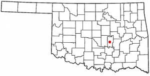
Bowlegs is a town in Seminole County, Oklahoma, United States. The population was 357 at the time of the 2020 census.

<span class="mw-page-title-main">Hilda, South Carolina</span> Town in South Carolina, United States

Hilda is a town in Barnwell County, South Carolina, United States. The population was 447 at the 2010 census..

<span class="mw-page-title-main">Blacksburg, South Carolina</span> Town in South Carolina, United States

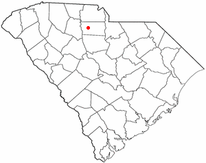
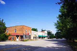
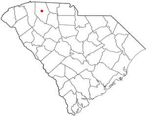
Blacksburg is a small town in Cherokee County, South Carolina, United States. The population was 1,848 at the 2010 census. The communities of Antioch, Cherokee Falls, Kings Creek, Cashion Crossroads, Buffalo, and Mount Paran are located near the town.

<span class="mw-page-title-main">Gaffney, South Carolina</span> City in South Carolina, United States

Gaffney is a city in and the seat of Cherokee County, South Carolina, United States, in the Upstate region of South Carolina. Gaffney is known as the "Peach Capital of South Carolina". The population was 12,539 at the 2010 census, with an estimated population of 12,609 in 2019. It is the principal city of the Gaffney, South Carolina, Micropolitan Statistical Area, which includes all of Cherokee County and which is further included in the greater Greenville-Spartanburg-Anderson, South Carolina Combined Statistical Area.

<span class="mw-page-title-main">Gayle Mill, South Carolina</span> Census-designated place in South Carolina, United States

Gayle Mill is a census-designated place (CDP) in Chester County, South Carolina, United States. The population was 913 at the 2010 census, down from 1,094 at the 2000 census.

<span class="mw-page-title-main">Boiling Springs, South Carolina</span> CDP in South Carolina, United States

Boiling Springs is a census-designated place (CDP) in Spartanburg County, South Carolina, United States. The population was 8,219 at the 2010 census.

<span class="mw-page-title-main">Campobello, South Carolina</span> Town in South Carolina, United States

Campobello is a town in Spartanburg County, South Carolina, United States, along the South Pacolet River. The population was 502 at the 2010 census.

<span class="mw-page-title-main">Central Pacolet, South Carolina</span> Town in South Carolina, United States

Central Pacolet is a town in Spartanburg County, South Carolina, United States, along the Pacolet River. The population was 216 at the 2010 census.

<span class="mw-page-title-main">Duncan, South Carolina</span> Town in South Carolina, United States

Duncan is a town in Spartanburg County, South Carolina, United States. Its population was 3,181 at the 2010 census.

<span class="mw-page-title-main">Landrum, South Carolina</span> City in South Carolina, United States

Landrum is a city in Spartanburg County, South Carolina, United States. The population was 2,376 at the 2010 census.

<span class="mw-page-title-main">Mayo, South Carolina</span> CDP in South Carolina, United States

Mayo is a census-designated place (CDP) in Spartanburg County, South Carolina, United States. The population was 1,592 at the 2010 census.

<span class="mw-page-title-main">Reidville, South Carolina</span> Town in South Carolina, United States

Reidville is a town in Spartanburg County, South Carolina, United States. The population was 601 at the 2010 census.

<span class="mw-page-title-main">Roebuck, South Carolina</span> CDP in South Carolina, United States

Roebuck is a census-designated place (CDP) in Spartanburg County, South Carolina, United States. The population was 2,200 at the 2010 census.

<span class="mw-page-title-main">Saxon, South Carolina</span> CDP in South Carolina, United States

Saxon is a census-designated place (CDP) in Spartanburg County, South Carolina, United States. The population was 3,424 at the 2010 census.

Southern Shops is a census-designated place (CDP) in Spartanburg County, South Carolina, United States. The population was 3,663 at the 2020 census.

<span class="mw-page-title-main">Valley Falls, South Carolina</span> CDP in South Carolina, United States

Valley Falls is a census-designated place (CDP) in Spartanburg County, South Carolina, United States. The population was 6,299 at the 2010 census.

<span class="mw-page-title-main">Locust, North Carolina</span> City in North Carolina, United States

Locust is a small rural city in Stanly and Cabarrus counties in the U.S. state of North Carolina. The population was 2,930 at the 2010 census.

<span class="mw-page-title-main">Chesnee, South Carolina</span> City in South Carolina, United States

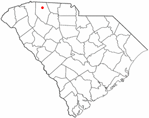
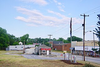
Chesnee is a city in Spartanburg and Cherokee counties, in the U.S. state of South Carolina. The population was 868 as of the 2010 census.

References

  1. "ArcGIS REST Services Directory". United States Census Bureau. Retrieved October 15, 2022.
  2. 1 2 "Census Population API". United States Census Bureau. Retrieved October 15, 2022.
  3. 1 2 "U.S. Census website". United States Census Bureau . Retrieved January 31, 2008.
  4. "US Board on Geographic Names". United States Geological Survey. October 25, 2007. Retrieved January 31, 2008.
  5. "Race, Hispanic or Latino, Age, and Housing Occupancy: 2010 Census Redistricting Data (Public Law 94-171) Summary File (QT-PL), Cowpens town, South Carolina". United States Census Bureau . Retrieved August 16, 2011.
  6. Wikisource-logo.svg One or more of the preceding sentences incorporates text from a publication now in the public domain :  Chisholm, Hugh, ed. (1911). "Cowpens". Encyclopædia Britannica . Vol. 7 (11th ed.). Cambridge University Press. p. 348.
  7. Moyer, Armond; Moyer, Winifred (1958). The origins of unusual place-names. Keystone Pub. Associates. p. 28.
  8. "The Battle of Cowpens". The AmericanRevolution.org. September 17, 2011.
  9. "National Register Information System". National Register of Historic Places . National Park Service. July 9, 2010.
  10. "US Gazetteer files: 2010, 2000, and 1990". United States Census Bureau. February 12, 2011. Retrieved April 23, 2011.
  11. "Census of Population and Housing". Census.gov. Retrieved June 4, 2015.
  12. "Explore Census Data". data.census.gov. Retrieved December 10, 2021.
  13. "South Carolina libraries and archives". SCIWAY. Retrieved June 13, 2019.