
Derry, officially Londonderry, is the largest city in County Londonderry, the second-largest in Northern Ireland and the fifth-largest on the island of Ireland. The old walled city lies on the west bank of the River Foyle, which is spanned by two road bridges and one footbridge. The city now covers both banks.

Craigavon is a town in northern County Armagh, Northern Ireland. Its construction began in 1965 and it was named after the first Prime Minister of Northern Ireland: James Craig, 1st Viscount Craigavon. It was intended to be the heart of a new linear city incorporating Lurgan and Portadown, but this plan was mostly abandoned and later described as having been flawed. Among local people today, "Craigavon" refers to the area between the two towns. It is built beside a pair of artificial lakes and is made up of a large residential area (Brownlow), a second smaller one (Mandeville), plus a central area (Highfield) that includes a substantial shopping centre, a courthouse and the district council headquarters. The area around the lakes is a public park and wildlife haven made up of woodland with walking trails. There is also a watersports centre, golf course and ski slope in the area. In most of Craigavon, motor vehicles are completely separated from pedestrians, and roundabouts are used extensively. It hosted the headquarters of the former Craigavon Borough Council.
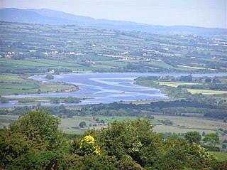
The River Foyle is a river in west Ulster in the northwest of the island of Ireland, which flows from the confluence of the rivers Finn and Mourne at the towns of Lifford in County Donegal, Republic of Ireland, and Strabane in County Tyrone, Northern Ireland. From here it flows to the city of Derry, where it discharges into Lough Foyle and, ultimately, the Atlantic Ocean. The total length of the River Foyle is 32 km (20 mi). The river separates part of County Donegal from parts of both County Londonderry and County Tyrone. The district of County Donegal that borders the western bank of the River Foyle is traditionally known as the Laggan. This district includes the villages of St Johnston and Carrigans, both of which are nestled on the banks of the River.

Free Derry was a self-declared autonomous Irish nationalist area of Derry, Northern Ireland that existed between 1969 and 1972 during the Troubles. It emerged during the Northern Ireland civil rights movement, which sought to end discrimination against the Irish Catholic/nationalist minority by the Protestant/unionist government. The civil rights movement highlighted the sectarianism and police brutality of the overwhelmingly Protestant police force, the Royal Ulster Constabulary (RUC).

The Battle of the Bogside was a large three-day riot that took place from 12 to 14 August 1969 in Derry, Northern Ireland. Thousands of Catholic/Irish nationalist residents of the Bogside district, organised under the Derry Citizens' Defence Association, clashed with the Royal Ulster Constabulary (RUC) and loyalists. It sparked widespread violence elsewhere in Northern Ireland, led to the deployment of British troops, and is often seen as the beginning of the thirty-year conflict known as the Troubles.
The Northern Ireland Civil Rights Association (NICRA) (Irish: Cumann Cearta Sibhialta Thuaisceart Éireann) was an organisation that campaigned for civil rights in Northern Ireland during the late 1960s and early 1970s. Formed in Belfast on 9 April 1967, the civil rights campaign attempted to achieve reform by publicising, documenting, and lobbying for an end to discrimination against Catholics in areas such as elections (which were subject to gerrymandering and property requirements), discrimination in employment, in public housing and abuses of the Special Powers Act.
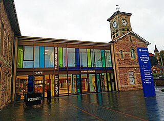
Derry ~ Londonderry railway station, also known as North West Transport Hub or Waterside railway station, is a railway terminus in Derry, Northern Ireland, on the east bank of the River Foyle, operated by Northern Ireland Railways and its 8th biggest station across the network with 723,776 passengers in the 22/23 year. It is on the Belfast–Derry railway line, terminating at Belfast Great Victoria Street.

The Foyle Bridge is a bridge in Derry, Northern Ireland. The central span of the bridge is the longest on the island of Ireland, at 234 metres (767 ft), and the whole suspended bridge structure including the approach spans is 866 metres long (2839 ft).

The Strabane Canal is a short (6.5 km) canal in County Tyrone, Northern Ireland. It connected the market town of Strabane to the navigable River Foyle and from there to the port of Foyle Port on the north coast of Ireland. The canal opened in 1796 and closed in 1962.
The Derry Housing Action Committee (DHAC), was an organisation formed in 1968 in Derry, Northern Ireland to protest about housing conditions and provision.

The A6 road in Northern Ireland runs for 71.4 miles (114.9 km) from Belfast to Derry, via County Antrim and County Londonderry. While stretches of the road before Randalstown have now been superseded by a motorway, the A6 remains one of the most important arterial routes in Northern Ireland, connecting its two largest cities and urban areas. Between Randalstown and Derry, the road forms part of European route E16.

Londonderry Port, now operating as Foyle Port, is a port located on Lough Foyle in Northern Ireland. It is the United Kingdom’s most westerly port and an important northerly port on the island of Ireland. The current port is at Lisahally, County Londonderry, though historically the port was upriver in the city of Derry itself. It is operated by the Londonderry Port and Harbour Commissioners, whose former offices, just north of the city's walls, are now a museum.

The Waterside generally refers to the part of Derry on the east bank of the River Foyle. Traditionally, the Waterside ends at the Caw roundabout near the Foyle Bridge. Areas such as Eglinton and Limavady are not part of the Waterside.
Events during the year 1968 in Northern Ireland.

The Peace Bridge is a cycle and foot bridge across the River Foyle in Derry, Northern Ireland. It opened on 25 June 2011, connecting Ebrington Square with the rest of the city centre. It is the newest of three bridges in the city, the others being the Craigavon Bridge and the Foyle Bridge. The 235 metres (771 ft) bridge was designed by AECOM, who also designed the Sutong Yangtze River Bridge, and Wilkinson Eyre Architects, who also designed the Gateshead Millennium Bridge.

The City of Derry Tramways was a tramway in Derry, Ireland that operated from 1897 until 1919. This was a standard gauge line served by horse trams and was never electrified.

Londonderry Victoria Road railway station served Derry, County Londonderry, in Northern Ireland.

The A40 links Derry in the North West of Northern Ireland to Raphoe in County Donegal.

Ebrington Barracks was a military installation on the east bank of the River Foyle in Derry, Northern Ireland.
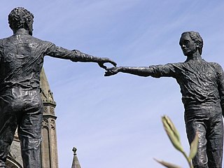
Hands Across the Divide is a sculpture in Derry, Northern Ireland. The statue was created by Maurice Harron, and erected in 1992. It stands on the western side of the Craigavon Bridge and symbolizes reconciliation between both sides of the political divide during The Troubles.

