Related Research Articles

The Delaware and Raritan Canal is a canal in central New Jersey, United States, built in the 1830s, that served to connect the Delaware River to the Raritan River. It was an efficient and reliable means of transportation of freight between Philadelphia and New York City, especially coal from the anthracite fields in eastern Pennsylvania, during much of the 19th and early 20th centuries. The canal allowed shippers to cut many miles off the existing route from the Pennsylvania coal fields, down the Delaware, around Cape May, and up along the Atlantic Ocean coast to New York City.

South Jersey comprises the southern portion of the U.S. state of New Jersey, between the lower Delaware River and the Atlantic Ocean. The designation of southern New Jersey with a distinct toponym is a colloquial one rather than an administrative one, reflecting not only geographical but also perceived cultural differences from the northern part of the state, with no official definition. Though definitions of South Jersey may vary, most of South Jersey is generally considered to be part of the Philadelphia Metropolitan Area.

Williamsbridge is a neighborhood geographically located in the north-central portion of the Bronx in New York City. Its boundaries, starting from the north and moving clockwise are East 222nd Street to the north, Boston Road to the east, East Gun Hill Road to the south, and the Bronx River to the west. White Plains Road is the primary thoroughfare through Williamsbridge.
The United New Jersey Railroad and Canal Company (UNJ&CC) was a railroad company which began as the important Camden & Amboy Railroad (C&A), whose 1830 lineage began as one of the eight or ten earliest permanent North American railroads, and among the first common carrier transportation companies whose prospectus marketed an enterprise aimed at carrying passengers fast and competing with stagecoaches between New York Harbor and Philadelphia-Trenton. Among the other earliest chartered or incorporated railroads, only the Mohawk and Hudson Railroad and Baltimore and Ohio Railroad were chartered with passenger services in mind. Later, after mergers, the UNJ&CC became a subsidiary part of the Pennsylvania Railroad (PRR) system in New Jersey by the later merger and acquisition of several predecessor companies in 1872; these purchases also included the PRR's main line to New York City. Prior to 1872, its main lines were the Camden and Amboy Rail Road and Transportation Company, the first railroad in New Jersey and one of the first railroads in the United States.
The city of Minneapolis, Minnesota, United States is officially defined by the Minneapolis City Council as divided into eleven communities, each containing multiple official neighborhoods. Informally, there are city areas with colloquial labels. Residents may also group themselves by their city street suffixes, North, Northeast, South, Southeast, and Southwest.

Pavonia Terminal was the Erie Railroad terminal on the Hudson River situated on the landfilled Harsimus Cove in Jersey City, New Jersey. The station opened in 1861 and closed in 1958 when the Erie Railroad moved its passenger services to nearby Hoboken Terminal. The New York, Susquehanna and Western Railway also ran commuter trains from the terminal and various street cars, ferries and the underground Hudson and Manhattan Railroad serviced the station. The station was abandoned in 1958 and demolished in 1961. The site was eventually redeveloped into the Newport district in the late 20th century.

Pavonia Yard is a Conrail Shared Assets Operations (CSAO) rail yard in Camden, New Jersey.

36th Street is an NJ Transit station on the River Line light rail system, located off 36th Street and River Road in the Delaware Gardens neighborhood of Pennsauken Township, in Camden County, New Jersey, United States. It is situated north of Pavonia Yard at the city line with Camden, and as such is the southernmost station of three along the River Line within Pennsauken.

Bergen Hill refers to the lower Hudson Palisades in New Jersey, United States, where they emerge on Bergen Neck, which in turn is the peninsula between the Hackensack and Hudson Rivers, and their bays. In Hudson County, it reaches a height of 260 feet.
Stockton Township was a township that existed in Camden County, New Jersey, United States, from 1859 until its dissolution in 1899.

Cannondale is a census-designated place (CDP) within the town of Wilton in Fairfield County, Connecticut. It had a population of 141 at the 2010 census. The neighborhood consists of many old homes on large, almost rural lots now largely wooded. The English first settled the land in the 17th century. At the center of Cannondale is Cannon Crossing, a small shopping village of boutiques and restaurants made up of 19th-century buildings restored by the late actress June Havoc in the late 1970s on the east side of Cannondale Railroad Station. Both are part of Cannondale Historic District, which encompasses the central part of Cannondale and most of its significant historical buildings.

Communipaw is an unincorporated community and neighborhood located within Jersey City in Hudson County, New Jersey, United States. It is located west of Liberty State Park and east of Bergen Hill, and the site of one of the earliest European settlements in North America. It gives its name to the historic avenue which runs from its eastern end near Liberty State Park Station through the neighborhoods of Bergen-Lafayette and the West Side that then becomes the Lincoln Highway. Communipaw Junction, or simply, The Junction, is an intersection where Communipaw, Summit Avenue, Garfield Avenue, and Grand Street meet, and where the toll house for the Bergen Point Plank Road was situated. Communipaw Cove at Upper New York Bay, is part of the 36-acre (150,000 m2) state nature preserve in the park and one of the few remaining tidal salt marshes in the Hudson River estuary.
Harsimus is a neighborhood within Downtown Jersey City, Hudson County, New Jersey, United States. The neighborhood stretches from the Harsimus Stem Embankment on the north to Christopher Columbus Drive on the south between Coles Street and Grove Street or more broadly, to Marin Boulevard. It borders the neighborhoods of Hamilton Park to the north, Van Vorst Park to the south, the Village to the west, and the Powerhouse Arts District to the east. Newark Avenue has traditionally been its main street. The name is from the Lenape, used by the Hackensack Indians who inhabited the region and could be translated as Crow’s Marsh. From many years, the neighborhood was part of the "Horseshoe", a political delineation created by its position between the converging rail lines and political gerrymandering.
Curries Woods is a neighborhood in the southern part of Greenville in Jersey City, New Jersey bordering Bayonne. It was named after James Curie, who was on the town Committee for Greenville when it was its own Township in the 19th century. The area remained rural until the later part of the century when the Central Railroad of New Jersey built a line connecting ferries to Elizabeth, New Jersey and New York City. Currie's Woods still remained untouched through the late part of the century and it was valued for its woods, rocky shore and dunes on Newark Bay. A lot of the land was eventually lost, but a tract was set aside in the early part of the 20th century. A small cemetery, the Old Greenville Cemetery, was nearby. This park lost much of its land to the city's largest Housing Authority project in 1959, except a small tract in Bayonne, Mercer Park.
Bergen-Lafayette is a section of Jersey City, New Jersey.

County Route 617 is 4.55 miles (7.32 km) long and follows one street, Summit Avenue along the ridge of the Hudson Palisades in Hudson County, New Jersey. Its southern end is CR 622, or Grand Street, at Communipaw Junction in the Bergen-Lafayette Section of Jersey City. Its northern end is CR 691, 32nd Street, a section of the Bergen Turnpike, in Union City.
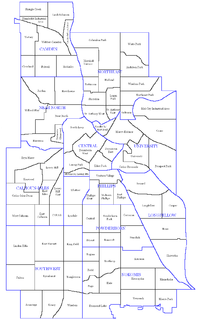
Beideman is a neighborhood name in the East Camden section of the City of Camden, New Jersey, USA. According to the 2000 U.S. Census, Beideman has a population of 5,677. The neighborhood name Beideman originates from a prominent family that lived there, with several notable members including Benjamin C. Beideman and Horace B. Beideman. The name Beideman has been frequently misspelled as "Biedman" or "Biedeman". The East Camden neighborhoods of Beideman and Pavonia are also considered part of the neighborhood of Cramer Hill.
Parkside is a neighborhood in Camden, New Jersey. Located near the Cooper River, the neighborhood has a population of 4,494. Our Lady of Lourdes Medical Center and Harleigh Cemetery are located in the neighborhood.
Stockton is a neighborhood and former municipality in Camden, New Jersey, United States. It has a population of 6,479.
References
- ↑ The Story Of New Jersey's Civil Boundaries 1606-1968
- 1 2 "CAMDEN - Cramer Hill". Dvrbs.com. Retrieved 2014-06-29.
- ↑ Map of neighborhood names
- ↑ "Camden Facts: Cramer Hill/Pavonia". Camconnect.org. Retrieved 2012-02-04.
- ↑ "You deserve green space, too. Illegal dumping spot in city transformed into nature preserve". May 2019.
- ↑ "Nature preserve meant to be 'an urban oasis' opens in Camden's Cramer Hill section".
