Tiverton is a town and civil parish in the English county of Devon and the main commercial and administrative centre of the Mid Devon district. It has become a dormitory town for Exeter and Taunton. The estimated population in 2019 was 20,587. The total area of the two County Council Divisions had a population of 38,191 in 2019.

The Blackdown Hills are a range of hills along the Somerset-Devon border in south-western England, which were designated an Area of Outstanding Natural Beauty (AONB) in 1991.
Woodbury is a village and civil parish in East Devon in the English county of Devon, 7 miles (11 km) south east of the city of Exeter. At the 2011 Census the village had a population of 1,605, and the parish had a population of 3,466. It lies on the east bank of the Exe Estuary, has borders – clockwise from the estuary – with the district of Exeter and then the parishes of Clyst St George, Clyst St Mary, Farringdon, Colaton Raleigh, Bicton and Lympstone. Woodbury is part of the electoral ward of Woodbury and Lympstone whose population at the 2011 Census was 5,260.
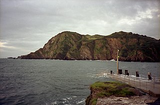
Hillsborough is a local nature reserve in Ilfracombe, North Devon. It is known locally as the sleeping elephant. It was bought by the local council in the late nineteenth century to prevent development on the site. As well as a pleasant coastal area where visitors may roam, it includes the remains of an Iron Age hill fort.
Cadbury Castle is an Iron Age Hillfort close to Bickleigh, Devon, England. It was later encamped by the Parliamentarian forces during the English Civil War under Thomas Fairfax when he laid siege to Bickleigh Castle.

Huntsham Castle, Devon, England is an Iron Age Hill fort enclosure near the village of Huntsham, it is located 260 m (850 ft) above sea level on the edge of the former Parish of Tiverton. The monument includes a slight univallate hillfort situated on a prominent hill overlooking the valleys of two separate tributaries to the River Lowman. The monument survives as a sub-circular enclosure, defining an area which slopes gently down to the south and measures approximately 150m in diameter. It is clearly demarcated on all sides by a rampart which varies in height from 1m up to 2.4m internally, being generally of greater height on the northern side of the enclosure. Externally this rampart is up to 2.9m high. Surrounding the rampart is an outer ditch which measures up to 5.4m wide and 0.4m deep and this is visible on all sides of the monument, although it is predominantly preserved as a buried feature. On the north eastern side, the outer edge of this ditch is defined by a field boundary bank and the infilled ditch has been used in the past as a track. There is an inturned entrance on the north eastern side which measures 7m wide, and the inturned banks are up to 2.2m wide and 0.4m high. The enclosure is crossed by a parish boundary bank which measures up to 2m wide and 1.5m high, and has been partially cut at the north eastern corner by a quarry, approximately 20m long, 15m wide and up to 2.8m deep, which lies to the north of the entrance. A further quarry lies to the south of the parish boundary bank, on the western side of the enclosure and measures 8.7 metres (29 ft) long, 5.3 metres (17 ft) wide and up to 1 metre (3.3 ft) deep. A third quarry lies to the north west and has partially cut into the ditch and rampart on this side; however much of this quarry lies just beyond the monument itself. A further entrance to the enclosure may lie on the western side, where the rampart is seen to kink slightly inwards. The stock proof fences around the rampart and ditch, the gates and gateposts which facilitate access, the Ordnance Survey triangulation point which is situated on the north eastern side of the enclosure just above the quarry, and the field boundary bank which defines the outer edge of the ditch in the north eastern corner are excluded from the scheduling, although the ground beneath all these features is included.

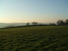
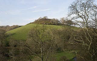
Castle Close is a circular earthwork located near Stoodleigh in Mid Devon, England at OS grid reference SS937181. It is described on maps as a settlement. Situated some 208 metres above sea level, overlooking the River Exe, it is most likely to be an Iron Age Hill fort or enclosure.

Stoodleigh is a village and civil parish in the Mid Devon district of Devon, England, located 6 miles (10 km) north of Tiverton and 5 miles (8 km) south of Bampton. It is situated 800 feet (240 m) above the Exe Valley, close to the Devon / Somerset border. The centre of the village is a conservation area.

Woodbury Castle is an Iron Age hillfort near the village of Woodbury in the English county of Devon, some eight miles southeast of the city of Exeter.
Berry Castle is an earthwork probably dating to the Iron Age close to Black Dog in Devon north of Crediton and west of Tiverton. It does not fit the traditional pattern of an Iron Age Hill fort. Although the earthwork would seem to be an incomplete enclosure, it is not at the top of a hill, although it is on the south east slope of a major hill which peaks at 199 Metres above Sea Level.

Castle Dyke is an Iron Age hill fort situated between Chudleigh and Dawlish in Devon, England. The fort is situated on a Hilltop at approx 140 metres above sea level.

Raddon Top is the highest point of the Raddon Hills, a small ridge of hills in the Shobrooke area of Mid Devon. The summit is at some 235 metres above sea level, making it a significant feature in the surrounding countryside.

Roborough Castle is an Iron Age enclosure or hill fort situated close to Lynton in Devon, England. The fort is situated on the North East edge of a Hillside forming a promontory above a tributary to the East Lyn River known as Hoaroak Water at approx 320 Metres above Sea Level.

Bremridge Wood formerly part of the Domesday Book estate of Bremridge near South Molton, Devon, England, is the site of an Iron Age enclosure or hill fort. The earthwork is situated in woodland on a Hillside forming a promontory above the River Bray to the West of the Town at approx 175 Metres above Sea Level.
Newberry Castle is an Iron Age Hill Fort close to Combe Martin in Devon, England.It takes the form of an earthwork hillside enclosure close on an outcrop of a hill on the north eastern shoulder of Newberry Hill at an elevation 110 Metres above Sea Level.
Lee Wood is the location of an Iron Age enclosure or hill fort situated near to Braunton and Barnstaple in Devon, England. The enclosure is situated on a sloping Hillside forming a promontory above the Knowle Water at approx 120 Metres above Sea Level to the north east of Braunton and north west of Barnstaple.

Today Clyst Heath is a suburb to the south east of the city of Exeter, Devon, England. An area of relatively high ground to the west of the River Clyst, it remained heathland until the early nineteenth century when it was cultivated for the first time.

Black Dog is a village in Mid Devon, ten miles west of Tiverton and six miles north of Crediton.
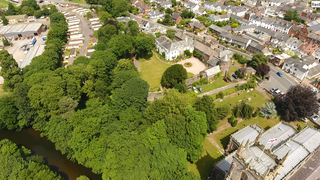
Tiverton Castle is the remains of a medieval castle dismantled after the Civil War and thereafter converted in the 17th century into a country house. It occupies a defensive position above the banks of the River Exe at Tiverton in Devon.
Martin Dunsford (1744–1807) of Tiverton in Devon, was an English merchant and Dissenter, known as an antiquarian and radical politician. His work Memoirs of the Town and Parish of Tiverton is noted as an attempt to write of the town as a whole community.