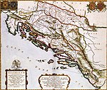
Lika is a traditional region of Croatia proper, roughly bound by the Velebit mountain from the southwest and the Plješevica mountain from the northeast. On the north-west end Lika is bounded by Ogulin-Plaški basin, and on the south-east by the Malovan pass. Today most of the territory of Lika is part of Lika-Senj County. Josipdol, Plaški and Saborsko are part of Karlovac County and Gračac is part of Zadar County.

The Military Frontier was a borderland of the Habsburg monarchy and later the Austrian and Austro-Hungarian Empire. It acted as the cordon sanitaire against incursions from the Ottoman Empire.

The Bjelovar-Križevci County was a historic administrative subdivision of the Kingdom of Croatia-Slavonia. Croatia-Slavonia was an autonomous kingdom within the Lands of the Crown of Saint Stephen (Transleithania), the Hungarian part of the dual Austro-Hungarian Empire. Its territory is now in northern Croatia. Belovár and Kőrös are the Hungarian names for the cities Bjelovar and Križevci, respectively. The capital of the county was Bjelovar.
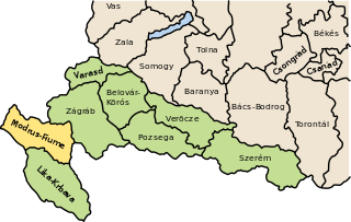
The Modruš-Rijeka County was a historic administrative subdivision of the Kingdom of Croatia-Slavonia. Croatia-Slavonia was an autonomous kingdom within the Lands of the Crown of Saint Stephen (Transleithania), the Hungarian part of the dual Austro-Hungarian Empire. Its territory is now in western Croatia. Modruš is a small town near Ogulin; Rijeka is a large city on the Adriatic coast. However, Rijeka was not part of the Modruš-Rijeka County, but under the direct administration of Hungary. The capital of the county was Ogulin.

Syrmia County was a historic administrative subdivision (županija) of the Kingdom of Croatia-Slavonia. Croatia-Slavonia was an autonomous kingdom within the Lands of the Crown of Saint Stephen (Transleithania), the Hungarian part of Austria-Hungary. The region of Syrmia is today split between Croatia and Serbia. The capital of the county was Vukovar.

The Austro-Hungarian Army or Imperial and Royal Army was the land force of the Austro-Hungarian Dual Monarchy from 1867 to 1918. It was composed of three parts: the joint army, the Imperial Austrian Landwehr, and the Royal Hungarian Honvéd.

The Kingdom of Slavonia was a kingdom of the Habsburg monarchy and the Austrian Empire that existed from 1699 to 1868. The kingdom included northern parts of present-day regions of Slavonia and Syrmia. The southern parts of these regions were part of the Slavonian Military Frontier, which was a component of the Military Frontier separating the Habsburg monarchy from the Ottoman Empire.

The Slavonian Military Frontier was a district of the Military Frontier, a territory in the Habsburg monarchy, first during the period of the Austrian Empire and then during the Austro-Hungarian Monarchy. It was formed out of territories the Habsburgs conquered from the Ottoman Empire and included southern parts of Slavonia and Syrmia; today the area it covered is mostly in eastern Croatia, with its easternmost parts in northern Serbia

The Uskoks were irregular soldiers in Habsburg Croatia that inhabited areas on the eastern Adriatic coast and surrounding territories during the Ottoman wars in Europe. Bands of Uskoks fought a guerrilla war against the Ottomans, and they formed small units and rowed swift boats. Since the uskoks were checked on land and were rarely paid their annual subsidy, they resorted to acts of piracy.
Šokci are a South Slavic ethnic group native to historical regions of Baranya, Bačka, Slavonia and Syrmia. These regions today span eastern Croatia, southwestern Hungary, and northern Serbia. They primarily self-identify as a subgroup of Croats and therefore they are not considered a separate ethnicity in Croatia and elsewhere.

The Kingdom of Croatia was part of the Lands of the Hungarian Crown, but was subject to direct Imperial Austrian rule for significant periods of time, including its final years. Its capital was Zagreb. It was also a part of the lands of the Habsburg monarchy from 1527, following the Election in Cetin, and the Austrian Empire from 1804 to 1867.

Grenz infantry or Grenzers or Granichary were light infantry troops who came from the Military Frontier in the Habsburg monarchy. This borderland formed a buffer zone between Christian Europe and the Ottoman Empire, and the troops were originally raised to defend their homelands against the Ottoman Turks. When there was no danger of war against the Ottomans, the Grenzer regiments were employed by the Habsburgs in other theatres of war, although one battalion of each regiment would always remain guarding the border.
Names of the Serbs and Serbia are terms and other designations referring to general terminology and nomenclature on the Serbs and Serbia. Throughout history, various endonyms and exonyms have been used in reference to ethnic Serbs and their lands. Basic terms, used in Serbian language, were introduced via classical languages into other languages, including English. The process of interlingual transmission began during the early medieval period, and continued up to the modern times, being finalized in major international languages at the beginning of the 20th century.

The Hundred Years' Croatian–Ottoman War is the name of a sequence of conflicts, mostly of relatively low intensity, between the Ottoman Empire and the medieval Kingdom of Croatia, and the later Habsburg Kingdom of Croatia. Except for periods of "small" borderland warfare, the conflict also saw episodes of major conquest campaigns of Croatian land undertaken by the Ottomans especially during the 16th century.

Slabinja is a village in the Sisak-Moslavina County in the central part of Croatia. It is in the Una Valley near the border with Bosnia and Herzegovina, 12.6 kilometres (7.8 mi) southeast of the town of Hrvatska Kostajnica, 9.7 kilometres (6 mi) northwest of the village of Hrvatska Dubica, and 106 kilometres (66 mi) southeast of Croatian capital Zagreb, at the south fringe of the Banovina region. Slabinja is a dormitory village with a resident population of just over 250 people.
Statuta Valachorum was a decree issued by Emperor Ferdinand II of the Habsburg monarchy on 5 October 1630 that defined the rights of "Vlachs" in the Military Frontier, in a way that it placed them under direct rule by Vienna, removing the jurisdiction of the Croatian parliament. This was one of three major laws enacted in the early 17th century on the taxation and tenancy rights of the Vlachs, together with the earlier 1608 decree by Emperor Rudolf II and a 1627 decree by Ferdinand.
The term Vlachs was initially used in medieval Croatian and Venetian history for a Romance-speaking pastoralist community, called "Vlachs" and "Morlachs", inhabiting the mountains and lands of the Croatian Kingdom and the Republic of Venice from the early 14th century. By the end of the 15th century they were highly assimilated with the Slavs and lost their language or were at least bilingual, while some communities managed to preserve and continue to speak their language (Istro-Romanians).
The Varaždin Generalate, also known as the Windische Grenze in German, was a province of the Military Frontier of the Habsburg monarchy, that existed between 1531 and the 19th century. While the Generalate was originally based in Warasdin (Varaždin), Varaždin County, including the city, was removed from the Military Frontier in the 18th century; the district the Generalate controlled was thereafter centered on Bellowar (Bjelovar), which also briefly acted as its administrative center until it was moved to Zagreb in 1787.
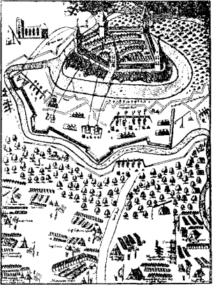
The siege of Virovitica was one of the first battles of Croatian–Slavonian theater during Great Turkish War. The siege took place in July 1684, and it ended with the Ottoman garrison's surrender and Habsburg-Croatian capture of town. Due to its capture in early phase of the war, the town became a vital Habsburg base for further operations in Slavonia.
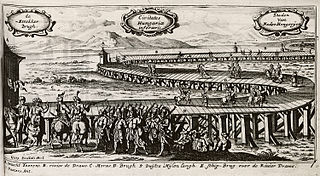
Croatian-Slavonian theater in Great Turkish War, concerns military operations undertaken during Great Turkish War of 1684-1689 by the forces of Holy League against the Ottoman Empire on territories of Croatia, Slavonia and Dalmatia. The war was concluded by Treaty of Karlowitz in 1699, which significantly eased off the Ottoman grip off Croatia.