Crowley County, Colorado

Last updated

Crowley County
Crowley County Justice Center.JPG
The Crowley County Justice Center in Ordway.
Map of Colorado highlighting Crowley County.svg
Location within the U.S. state of Colorado
Colorado in United States.svg
Colorado's location within the U.S.
Coordinates: 38°20′N103°47′W / 38.33°N 103.79°W / 38.33; -103.79
CountryFlag of the United States.svg United States
StateFlag of Colorado.svg  Colorado
FoundedMay 29, 1911
Named for John H. Crowley
Seat Ordway
Largest townOrdway
Area
  Total800 sq mi (2,000 km2)
  Land787 sq mi (2,040 km2)
  Water13 sq mi (30 km2)  1.6%
Population
 (2020)
  Total5,922
  Density7.5/sq mi (2.9/km2)
Time zone UTC−7 (Mountain)
  Summer (DST) UTC−6 (MDT)
Congressional district 4th
Website crowleycounty.colorado.gov

Crowley County is a county in Colorado. As of the 2020 census, the population was 5,922. [1] The county seat is Ordway. [2] It is also the poorest county in the country, with a per capita personal income of $22,240.

Contents

History

Crowley County was created by the Colorado legislature on May 29, 1911, out of the northern portions of Otero County. Previously both were parts of Bent County. The county was named for John H. Crowley, senator from Otero County to the state legislature at the time of the split. Its original inhabitants decades earlier were Native Americans, more Cheyenne than other tribes at the time the western expansion of the U.S. arrived.

The first significant development and settlement occurred in 1887 when the Missouri Pacific Railroad came through from the east, on its way to Pueblo and Colorado's rich gold fields of "Pikes Peak Or Bust".

The county seat is in Ordway, a town established in 1890 that quickly became the economic hub of the area. Other towns still existing along the Missouri Pacific Railroad's route are Sugar City, Crowley, and Olney Springs.

A few years later, developers brought a canal east from the Arkansas River, with ambitious plans to irrigate a million acres (4000 km2) in Kansas; instead, the canal petered out in Crowley County but did irrigate 57,000 acres (230 km2) along its length. This turned early Crowley County into a lush agricultural mecca at first.

By the 1970s almost all the water rights were sold from what is now called the Twin Lakes Canal to the fast-growing cities of Colorado's Front Range corridor. The area's economic activity has shifted toward ranching. Much of the land has returned to its original sparse prairie grassland conditions.

The Crowley School, which is now the Crowley County Heritage Center, is the county's only historic site listed on the U.S. National Register of Historic Places.

Crowley County also today hosts a state prison. The 2000 census showed 5,518 county residents, of which 1,955 were prisoners, giving Crowley County the highest percentage of incarcerated prisoners of any county in the U.S. The county maintained this position in the 2010 census, with 2,682 prisoners out of 5,823 residents.

Geography

According to the U.S. Census Bureau, the county has a total area of 800 square miles (2,100 km2), of which 787 square miles (2,040 km2) is land and 13 square miles (34 km2) (1.6%) is water. [3] Lake Meredith, which lies south of Ordway and Sugar City, is the largest of several lakes in the county. [4]

Adjacent counties

Major highways

Bicycle trail

Demographics

Historical population
CensusPop.Note
1920 6,383
1930 5,934−7.0%
1940 5,398−9.0%
1950 5,222−3.3%
1960 3,978−23.8%
1970 3,086−22.4%
1980 2,988−3.2%
1990 3,94632.1%
2000 5,51839.8%
2010 5,8235.5%
2020 5,9221.7%
2023 (est.)5,636 [5] −4.8%
U.S. Decennial Census [6]
1790-1960 [7] 1900-1990 [8]
1990-2000 [9] 2010-2020 [1]

As of the census [10] of 2000, there were 5,518 people, 1,358 households, and 957 families living in the county. The population density was 7 people per square mile (2.7 people/km2). There were 1,542 housing units at an average density of 2 units per square mile (0.77 units/km2). The racial makeup of the county was 82.95% White, 7.05% Black or African American, 2.59% Native American, 0.82% Asian, 0.02% Pacific Islander, 4.77% from other races, and 1.81% from two or more races. 22.54% of the population were Hispanic or Latino of any race.

There were 1,358 households, out of which 34.50% had children under the age of 18 living with them, 55.10% were married couples living together, 11.00% had a female householder with no husband present, and 29.50% were non-families. 25.70% of all households were made up of individuals, and 13.00% had someone living alone who was 65 years of age or older. The average household size was 2.59 and the average family size was 3.12.

In the county, the population was spread out, with 18.80% under the age of 18, 9.90% from 18 to 24, 39.60% from 25 to 44, 20.80% from 45 to 64, and 10.80% who were 65 years of age or older. The median age was 37 years. For every 100 females there were 205.40 males (this is the highest of any U.S. county/parish in 2000). For every 100 females age 18 and over, there were 240.90 males.

The median income for a household in the county was $26,803, and the median income for a family was $32,162. Males had a median income of $20,813 versus $21,920 for females. The per capita income for the county was $12,836. About 15.20% of families and 18.50% of the population were below the poverty line, including 23.60% of those under age 18 and 13.50% of those age 65 or over. More recent data, published in 2011, estimated that 48.1 percent of the county's residents lived in poverty, and of 3,197 counties ranked by the U.S. Census Bureau in 2011 for "estimated percent of people of all ages in poverty", Crowley was second. [11]

Census data for Crowley County includes 1,955 prisoners. The prison population is 19.23% Black, and 24.35% Hispanic. Without the prisoners, Crowley County would be 86.72% White, 0.36% Black, and 21.55% Hispanic. As a percentage of its population, Crowley County has more of its Census population in prison than any other county in the country. [12] [13]

Politics

Crowley is a predominantly Republican county. No Democratic presidential nominee has won Crowley County since Lyndon Johnson's 1964 landslide. Before that time, the county largely followed the patterns of Colorado politics in general, from strongly Democratic during the William Jennings Bryan and Woodrow Wilson eras to Republican leaning from the time of Wendell Willkie onwards.

United States presidential election results for Crowley County, Colorado [14]
Year Republican Democratic Third party
No.%No.%No.%
2020 1,27172.63%43724.97%422.40%
2016 1,07970.66%33922.20%1097.14%
2012 92461.52%53535.62%432.86%
2008 97662.64%55235.43%301.93%
2004 1,00667.38%47832.02%90.60%
2000 85559.17%51135.36%795.47%
1996 68049.60%55940.77%1329.63%
1992 60241.29%57039.09%28619.62%
1988 86257.47%63042.00%80.53%
1984 99365.03%51733.86%171.11%
1980 92662.86%47232.04%755.09%
1976 83454.90%66743.91%181.18%
1972 1,09470.67%41426.74%402.58%
1968 77550.36%56536.71%19912.93%
1964 69041.49%96758.15%60.36%
1960 1,09960.89%70539.06%10.06%
1956 1,22062.05%74537.89%10.05%
1952 1,54667.78%72631.83%90.39%
1948 1,02750.34%1,00449.22%90.44%
1944 1,21462.93%71036.81%50.26%
1940 1,41962.21%85037.26%120.53%
1936 92043.11%1,16354.50%512.39%
1932 81138.31%1,26659.80%401.89%
1928 1,24365.42%63533.42%221.16%
1924 1,08750.23%66730.82%41018.95%
1920 1,34860.64%79235.63%833.73%
1916 84740.47%1,16055.42%864.11%
1912 46728.35%71943.66%46127.99%

Communities

Towns

See also

Related Research Articles

<span class="mw-page-title-main">Concho County, Texas</span> County in Texas, United States

Concho County is a county located on the Edwards Plateau in the U.S. state of Texas. At the 2020 census, the population was 3,303. Its county seat is Paint Rock. The county was founded in 1858 and later organized in 1879. It is named for the Concho River.

<span class="mw-page-title-main">Otero County, New Mexico</span> County in New Mexico, United States

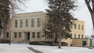
Otero County is a county located in the U.S. state of New Mexico. As of the 2020 census, the population was 67,839. Its county seat is Alamogordo. Its southern boundary is the Texas state line. It is named for Miguel Antonio Otero, the territorial governor when the county was created.

<span class="mw-page-title-main">Chaves County, New Mexico</span> County in New Mexico, United States

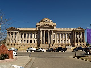
Chaves County is a county in New Mexico, United States. As of the 2020 census, the population was 65,157. Its county seat is Roswell. Chaves County was named for Colonel Jose Francisco Chaves, a military leader there during the Civil War and later in Navajo campaigns. The county was created by the New Mexico Territorial Legislature on February 25, 1889, out of land from Lincoln County.

<span class="mw-page-title-main">Yuma County, Colorado</span> County in Colorado, United States

Yuma County is a county located in the U.S. state of Colorado. As of the 2020 census, the population was 9,988. The county seat is Wray.

<span class="mw-page-title-main">Teller County, Colorado</span> County in Colorado, United States

Teller County is a county located in the U.S. state of Colorado. As of the 2020 census, the population was 24,710. The county seat is Cripple Creek, and the most populous city is Woodland Park.

<span class="mw-page-title-main">Pueblo County, Colorado</span> County in Colorado, United States

Pueblo County is a county located in the U.S. state of Colorado. As of the 2020 census, the population was 168,162. The county seat is Pueblo. The county was named for the historic city of Pueblo which took its name from the Spanish language word meaning "town" or "village". Pueblo County comprises the Pueblo, CO Metropolitan Statistical Area.

<span class="mw-page-title-main">Phillips County, Colorado</span> County in Colorado, United States

Phillips County is a county located in the U.S. state of Colorado. As of the 2020 census, the population was 4,530. The county seat is Holyoke. The county was named in honor of R.O. Phillips, a secretary of the Lincoln Land Company, who organized several towns in Colorado.

<span class="mw-page-title-main">Otero County, Colorado</span> County in Colorado, United States

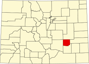
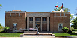
Otero County is a county located in the U.S. state of Colorado. As of the 2020 census, the population was 18,690. The county seat is La Junta. The county was named for Miguel Antonio Otero, one of the founders of the town of La Junta and a member of a prominent Hispanic family.

<span class="mw-page-title-main">Mineral County, Colorado</span> County in Colorado, United States

Mineral County is a county located in the U.S. state of Colorado. As of the 2020 census, the population was 865, making it the third-least populous county in Colorado, behind San Juan County and Hinsdale County. The county seat and only incorporated municipality in the county is Creede. The county was named for the many valuable minerals found in the mountains and streams of the area.

<span class="mw-page-title-main">Lincoln County, Colorado</span> County in Colorado, United States

Lincoln County is a county located in the U.S. state of Colorado. As of the 2020 census, the population was 5,675. The county seat is Hugo. The county obtains its name in memory of the United States President Abraham Lincoln. County was formed from portions of Bent and Elbert counties in 1889 from a restructuring of Colorado counties.

<span class="mw-page-title-main">Las Animas County, Colorado</span> County in Colorado, United States

Las Animas County is a county located in the U.S. state of Colorado. As of the 2020 census, the population was 14,555. The county seat is Trinidad. The county takes its name from the Mexican Spanish name of the Purgatoire River, originally called El Río de las Ánimas Perdidas en el Purgatorio, which means "River of the Lost Souls in Purgatory."

<span class="mw-page-title-main">Kit Carson County, Colorado</span> County in Colorado, United States

Kit Carson County is a county located in the U.S. state of Colorado. As of the 2020 census, the population was 7,087. The county seat is Burlington. The county was established in 1889 and named for American frontiersman and Indian fighter Kit Carson.

<span class="mw-page-title-main">Kiowa County, Colorado</span> County in Colorado, United States

Kiowa County is a county located in the U.S. state of Colorado. As of the 2020 census, the population was 1,446, making it the fifth-least populous county in Colorado. The county seat is Eads. The county was named for the Kiowa Nation of Native Americans.

<span class="mw-page-title-main">Gilpin County, Colorado</span> County in Colorado, United States

Gilpin County is a county located in the U.S. state of Colorado, smallest in land area behind only the City and County of Broomfield. As of the 2020 census, the population was 5,808. The county seat is Central City. The county was formed in 1861, while Colorado was still a territory, and was named after Colonel William Gilpin, the first territorial governor.

<span class="mw-page-title-main">Fremont County, Colorado</span> County in Colorado, United States

Fremont County is a county located in the U.S. state of Colorado. As of the 2020 census, the population was 48,939. The county seat is Cañon City. The county is named for 19th-century explorer and presidential candidate John C. Frémont.

<span class="mw-page-title-main">Bent County, Colorado</span> County in Colorado, United States

Bent County is a county located in the U.S. state of Colorado. As of the 2020 census, the population was 5,650. The county seat and only incorporated municipality is Las Animas. The county is named in honor of frontier trader William Bent.

<span class="mw-page-title-main">Cheraw, Colorado</span> Town in Otero County, Colorado, United States

Cheraw is a Statutory Town located in Otero County, Colorado, United States. The town population was 237 at the 2020 United States Census.

<span class="mw-page-title-main">Manzanola, Colorado</span> Town in Otero County, Colorado, United States

Manzanola is a Statutory Town in Otero County, Colorado, United States. The town population was 341 at the 2020 United States Census.

<span class="mw-page-title-main">Sky Lake, Florida</span> Census-designated place in Florida, United States

Sky Lake is a census-designated place (CDP) and an unincorporated area in Orange County, Florida, United States. The population was 6,153 at the 2010 census. It is part of the Orlando-Kissimmee, Florida Metropolitan Statistical Area.

<span class="mw-page-title-main">Doña Ana County, New Mexico</span> County in New Mexico, United States

Doña Ana County is located in the southern part of the State of New Mexico, United States. As of the 2020 U.S. Census, its population was 219,561, which makes it the second-most populated county in New Mexico. Its county seat is Las Cruces, the second-most populous municipality in New Mexico after Albuquerque, with 111,385 as of the 2020 U.S. Census.

References

  1. 1 2 "State & County QuickFacts". United States Census Bureau. Retrieved September 4, 2021.
  2. "Find a County". National Association of Counties. Archived from the original on May 31, 2011. Retrieved June 7, 2011.
  3. "US Gazetteer files: 2010, 2000, and 1990". United States Census Bureau. February 12, 2011. Retrieved April 23, 2011.
  4. "Lake Meredith". Geographic Names Information System . United States Geological Survey, United States Department of the Interior.
  5. "Annual Estimates of the Resident Population for Counties: April 1, 2020 to July 1, 2023". United States Census Bureau. Retrieved March 31, 2024.
  6. "U.S. Decennial Census". United States Census Bureau. Retrieved June 7, 2014.
  7. "Historical Census Browser". University of Virginia Library. Archived from the original on August 11, 2012. Retrieved June 7, 2014.
  8. "Population of Counties by Decennial Census: 1900 to 1990". United States Census Bureau. Retrieved June 7, 2014.
  9. "Census 2000 PHC-T-4. Ranking Tables for Counties: 1990 and 2000" (PDF). United States Census Bureau. Archived (PDF) from the original on March 27, 2010. Retrieved June 7, 2014.
  10. "U.S. Census website". United States Census Bureau . Retrieved May 14, 2011.
  11. "Table 1: 2011 Poverty and Median Income Estimates - Counties". Small Area Income and Poverty Estimates. U.S. Census Bureau. 2011. Archived from the original on October 10, 2013.
  12. Wagner, Peter; ‘Twenty one counties have twenty one percent of their population in prisons and jails’; Prison Policy Initiative, April 19, 2004
  13. Prison Policy Initiative; ‘Racial Geography of Mass Incarceration – Appendix A. Counties: Ratios of overrepresentation’
  14. Leip, David. "Dave Leip's Atlas of U.S. Presidential Elections". uselectionatlas.org. Retrieved May 26, 2017.

38°20′N103°47′W / 38.33°N 103.79°W / 38.33; -103.79