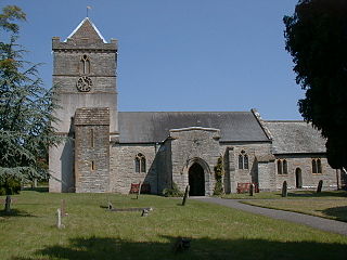
Puriton is a village and parish at the westerly end of the Polden Hills, in the Sedgemoor district of Somerset, England. The parish has a population of 1,968. The local parish church is dedicated to St Michael and All Angels. A chapel on Woolavington Road was converted to a private house some 20 years ago. The parish includes the hamlets of Dunball and Down End.
A motte-and-bailey castle is a European fortification with a wooden or stone keep situated on a raised area of ground called a motte, accompanied by a walled courtyard, or bailey, surrounded by a protective ditch and palisade. Relatively easy to build with unskilled labour, but still militarily formidable, these castles were built across northern Europe from the 10th century onwards, spreading from Normandy and Anjou in France, into the Holy Roman Empire in the 11th century. The Normans introduced the design into England and Wales. Motte-and-bailey castles were adopted in Scotland, Ireland, the Low Countries and Denmark in the 12th and 13th centuries. Windsor Castle, in England, is an example of a motte-and-bailey castle. By the end of the 13th century, the design was largely superseded by alternative forms of fortification, but the earthworks remain a prominent feature in many countries.

Castle Cary is a market town and civil parish in south Somerset, England, 5 miles (8 km) north west of Wincanton and 8 miles (12.9 km) south of Shepton Mallet, at the foot of Lodge Hill and on the River Cary, a tributary of the Parrett.

Sulgrave is a village and civil parish in West Northamptonshire, England, about 5 miles (8 km) north of Brackley. The village is just south of a stream that rises in the parish and flows east to join the River Tove, a tributary of the Great Ouse.

Sheriff Hutton is a village and civil parish in the Ryedale district of North Yorkshire, England. It lies about 10 miles (16 km) north by north-east of York.
Buckton Castle was a medieval enclosure castle near Carrbrook in Stalybridge, Greater Manchester, England. It was surrounded by a 2.8-metre-wide (9 ft) stone curtain wall and a ditch 10 metres (33 ft) wide by 6 metres (20 ft) deep. Buckton is one of the earliest stone castles in North West England and only survives as buried remains overgrown with heather and peat. It was most likely built and demolished in the 12th century. The earliest surviving record of the site dates from 1360, by which time it was lying derelict. The few finds retrieved during archaeological investigations indicate that Buckton Castle may not have been completed.

Loughor Castle is a ruined, medieval fortification located in the town of Loughor, Wales. The castle was built around 1106 by the Anglo-Norman lord Henry de Beaumont, during the Norman invasion of Wales. The site overlooked the River Loughor and controlled a strategic road and ford running across the Gower Peninsula. The castle was designed as an oval ringwork, probably topped by wicker fence defences, and reused the remains of the former Roman fort of Leucarum.

Ashton Keynes Castle was in the village of Ashton Keynes, near to the town of Cricklade in Wiltshire, England. It is also known as Hall's Close, while locals call it The Battlefield. The scheduled monument consists of a ringwork and bailey 100 metres (330 ft) west of Kentend Farm.
Bletchingley Castle is a ruined castle and set of earthworks partly occupied by three buildings. The Scheduled Ancient Monument is directly beside the Greensand Way below it to the south in the village of Bletchingley in Surrey. The site's tower standing from c.1170 to 1264 had a panorama from one of the narrower parts of the Greensand Ridge, which runs from mid-Kent to south-west Surrey.

Bryn Amlwg Castle was an enclosure castle near Anchor, Shropshire, abutting the England–Wales border. It is a scheduled monument, listed in 1930.

Clavering Castle remains are situated in the small parish village of Clavering in the county of Essex, England, 50m north of the church of St Mary and St Clement on the southern bank of the River Stort, some 10 kilometres (6.2 mi) north of Bishop's Stortford.

Barnard Castle is a ruined medieval castle situated in the town of the same name in County Durham, England.

The Grade I listed buildings in Somerset, England, demonstrate the history and diversity of its architecture. The ceremonial county of Somerset consists of a non-metropolitan county, administered by Somerset County Council, which is divided into five districts, and two unitary authorities. The districts of Somerset are West Somerset, South Somerset, Taunton Deane, Mendip and Sedgemoor. The two administratively independent unitary authorities, which were established on 1 April 1996 following the breakup of the county of Avon, are North Somerset and Bath and North East Somerset. These unitary authorities include areas that were once part of Somerset before the creation of Avon in 1974.

The Yarn Market in Dunster, Somerset, England was built in the early 17th century. It has been designated as a Grade I listed building and scheduled monument. Dunster was an important market place in the Middle Ages particularly following the construction of Dunster Castle and the establishment of the Priory Church of St George.

Pennard Castle is a ruined castle, near the modern village of Pennard on the Gower Peninsula, in south Wales. The castle was built in the early 12th century as a timber ringwork following the Norman invasion of Wales. The walls were rebuilt in stone by the Braose family at the turn of the 13th and 14th centuries, including a stone gatehouse. Soon afterwards, however, encroaching sand dunes caused the site to be abandoned and it fell into ruin. Restoration work was carried out during the course of the 20th century and the remains of the castle are now protected under UK law as a Grade II* listed building.

Culworth is a village and civil parish about 7 miles (11 km) north of Brackley in West Northamptonshire, England. Culworth is also about 7 miles (11 km) northeast of the north Oxfordshire town of Banbury.
There are over 670 scheduled monuments in the ceremonial county of Somerset in South West England. The county consists of a non-metropolitan county, administered by Somerset County Council, which is divided into five districts, and two unitary authorities. The districts of Somerset are West Somerset, South Somerset, Taunton Deane, Mendip and Sedgemoor. The two administratively independent unitary authorities, which were established on 1 April 1996 following the breakup of the county of Avon, are North Somerset and Bath and North East Somerset. These unitary authorities include areas that were once part of Somerset before the creation of Avon in 1974.
An enclosure castle is a fortified residence or stronghold, in which defence is facilitated by walls and towers. Such fortifications were usually composed of wood or stone, but there are later examples built of brick.

