Cut Bank, Montana

Last updated

Cut Bank
Cut Bank Creek Montana.jpg
Housing along Cut Bank Creek
Glacier County Montana Incorporated and Unincorporated areas Cut Bank Highlighted.svg
Location of Cut Bank, Montana
Coordinates: 48°38′5″N112°19′52″W / 48.63472°N 112.33111°W / 48.63472; -112.33111
Country United States
State Montana
County Glacier
Area
[1]
  Total1.16 sq mi (3.01 km2)
  Land1.16 sq mi (3.00 km2)
  Water0.00 sq mi (0.01 km2)
Elevation
3,773 ft (1,150 m)
Population
 (2020)
  Total3,056
  Density2,641.31/sq mi (1,020.07/km2)
Time zone UTC−7 (Mountain (MST))
  Summer (DST) UTC−6 (MDT)
ZIP code
59427
Area code 406
FIPS code 30-18775
GNIS feature ID0770395
Website cityofcutbank.org

Cut Bank is a city in and the county seat of Glacier County, Montana, United States, located just east of the "cut bank" (gorge) along Cut Bank Creek. [2] The population was 3,056 at the 2020 census, [3] The town began in 1891 with the arrival of the Great Northern Railway. [4]

Contents

Geography

Cut Bank is located in eastern Glacier County. The Blackfeet Indian Reservation is located just west of Cut Bank, on the western side of Cut Bank Creek.

According to the United States Census Bureau, the city has a total area of 0.99 square miles (2.56 km2), all land. [5]

The city is located 30 miles (48 km) south of the Canada–United States border. The name of the city comes from the cut bank (gorge) a scenic hazard to navigation and a geologic feature of the same name. The Cut Bank Creek river is spanned cliffs to cliffs by a scenic elevated railway bridge high above the canyon floor less than a mile from the edge of the town.

Climate

Cut Bank experiences a semi-arid climate (Köppen BSk), with long, cold, dry winters and short, warm, wetter summers. In winter, bitterly cold arctic air masse s move south and impact the eastern side of the American Continental Divide. During such invasions, Cut Bank, with its comparatively high elevation and topography, is frequently the coldest location in the lower 48 U.S. States. Being close to the eastern slopes of the Rocky Mountains also makes the area subject to occasional Chinook winds that can rapidly increase the local temperature.

Climate data for Cut Bank, Montana (Cut Bank Municipal Airport), 19912020 normals, extremes 1903present
MonthJanFebMarAprMayJunJulAugSepOctNovDecYear
Record high °F (°C)67
(19)
71
(22)
77
(25)
87
(31)
91
(33)
101
(38)
106
(41)
107
(42)
97
(36)
88
(31)
79
(26)
67
(19)
107
(42)
Mean maximum °F (°C)54.8
(12.7)
54.7
(12.6)
62.5
(16.9)
72.1
(22.3)
80.4
(26.9)
85.5
(29.7)
93.1
(33.9)
93.3
(34.1)
88.0
(31.1)
76.2
(24.6)
61.9
(16.6)
53.7
(12.1)
95.3
(35.2)
Mean daily maximum °F (°C)32.3
(0.2)
34.2
(1.2)
42.6
(5.9)
52.3
(11.3)
62.3
(16.8)
70.4
(21.3)
80.2
(26.8)
79.7
(26.5)
68.7
(20.4)
54.4
(12.4)
41.0
(5.0)
32.9
(0.5)
54.2
(12.3)
Daily mean °F (°C)21.8
(−5.7)
23.1
(−4.9)
31.1
(−0.5)
40.2
(4.6)
49.6
(9.8)
57.6
(14.2)
64.9
(18.3)
63.9
(17.7)
54.4
(12.4)
42.0
(5.6)
30.6
(−0.8)
22.8
(−5.1)
41.8
(5.4)
Mean daily minimum °F (°C)11.3
(−11.5)
12.0
(−11.1)
19.7
(−6.8)
28.1
(−2.2)
37.0
(2.8)
44.7
(7.1)
49.6
(9.8)
48.0
(8.9)
40.1
(4.5)
29.7
(−1.3)
20.2
(−6.6)
12.6
(−10.8)
29.4
(−1.4)
Mean minimum °F (°C)−18.9
(−28.3)
−14.0
(−25.6)
−5.6
(−20.9)
11.6
(−11.3)
23.4
(−4.8)
34.8
(1.6)
39.5
(4.2)
37.2
(2.9)
25.7
(−3.5)
9.1
(−12.7)
−6.8
(−21.6)
−15.3
(−26.3)
−28.8
(−33.8)
Record low °F (°C)−46
(−43)
−47
(−44)
−34
(−37)
−25
(−32)
9
(−13)
21
(−6)
32
(0)
25
(−4)
−4
(−20)
−14
(−26)
−33
(−36)
−46
(−43)
−47
(−44)
Average precipitation inches (mm)0.22
(5.6)
0.23
(5.8)
0.36
(9.1)
0.95
(24)
1.65
(42)
2.73
(69)
1.29
(33)
0.96
(24)
1.08
(27)
0.57
(14)
0.42
(11)
0.31
(7.9)
10.77
(274)
Average snowfall inches (cm)4.0
(10)
4.1
(10)
6.8
(17)
3.9
(9.9)
1.2
(3.0)
0.0
(0.0)
0.0
(0.0)
0.0
(0.0)
0.4
(1.0)
3.0
(7.6)
5.6
(14)
4.4
(11)
33.4
(83.5)
Average precipitation days (≥ 0.01 in)4.24.25.97.99.811.36.76.16.55.14.84.276.7
Average snowy days (≥ 0.1 in)4.94.87.03.20.90.00.00.00.52.54.55.233.5
Source: NOAA (snow, snow days 19812010) [6] [7] [8]

Demographics

Historical population
CensusPop.Note
1900 43
1910 5001,062.8%
1920 1,181136.2%
1930 845−28.5%
1940 2,509196.9%
1950 3,72148.3%
1960 4,53922.0%
1970 4,004−11.8%
1980 3,688−7.9%
1990 3,329−9.7%
2000 3,105−6.7%
2010 2,869−7.6%
2020 3,0566.5%
source: [9]

U.S. Decennial Census [10] [3]

2010 census

As of the 2010 census, [11] there were 2,869 people, 1,249 households and 739 families residing in the city. The population density was 2,927 inhabitants per square mile (1,130.1/km2). There were 1,441 housing units at an average density of 1,470 per square mile (567.6/km2). The racial makeup of the city was 74.7% White, 0.2% African American, 19.0% Native American, 0.5% Asian, 0.4% from other races, and 5.2% from two or more races. Hispanic or Latino of any race were 2.5% of the population.

There were 1,249 households, of which 30.3% had children under the age of 18 living with them, 43.4% were married couples living together, 10.6% had a female householder with no husband present, 5.1% had a male householder with no wife present, and 40.8% were non-families. 35.7% of all households were made up of individuals, and 14.6% had someone living alone who was 65 years of age or older. The average household size was 2.26 and the average family size was 2.94.

The median age was 41.2 years. 24.4% of residents were under the age of 18; 7.7% were between the ages of 18 and 24; 22.4% were from 25 to 44; 28.8% were from 45 to 64; and 16.8% were 65 years of age or older. The gender makeup of the city was 48.2% male and 51.8% female.

Education

The area school district is Cut Bank Public Schools, [12] with its components being Cut Bank Elementary School District and Cut Bank High School District. [13] Cut Bank Public Schools educates students from kindergarten through 12th grade. [14] Cut Bank High School's team name is the Wolves. [15]

Cut Bank has a public library, the Glacier County Library. [16]

Media

The Cut Bank Pioneer Press is a newspaper that provides both print and e-edition news. [17]

Transportation

Amtrak station in Cut Bank Cut Bank station.jpg
Amtrak station in Cut Bank

Cut Bank is served by Amtrak's Empire Builder long-distance train on its route from Chicago to Seattle/Portland. [18] There is one eastbound and one westbound train per day.

A train of the same name served the city under Amtrak's predecessor, the Great Northern Railway. The city, in conjunction with Amtrak and the current track owner BNSF Railway, recently repainted its historic train station in the traditional Great Northern depot colors.

The city contains an important railroad freight yard operated by the BNSF.

Cut Bank Municipal Airport is a public use airport 3 miles (4.8 km) southwest of Cut Bank. [19]

U.S. Route 2 passes through the city as Main Street, leading east 22 miles (35 km) to Interstate 15 at Shelby and west 34 miles (55 km) to Browning.

Notable people

See also

Related Research Articles

<span class="mw-page-title-main">Glacier County, Montana</span> County in Montana, United States

Glacier County is located in the U.S. state of Montana. As of the 2020 census, the population was 13,778. The county is located in northwestern Montana between the Great Plains and the Rocky Mountains, known to the Blackfeet as the "Backbone of the World". The county is geographically and culturally diverse and includes the Blackfeet Indian Reservation, Glacier National Park, and Lewis and Clark National Forest. The county is bordered by 75 miles of international boundary with two ports of entry open year-round and one seasonal international border crossing into Alberta, Canada.

<span class="mw-page-title-main">Chinook, Montana</span> City in Montana, United States

Chinook is a city in and the county seat of Blaine County, Montana, United States. The population was 1,185 at the 2020 census. Points of interest are the Bear Paw Battlefield Museum located in the small town's center and the Bear Paw Battlefield, located 20 miles (32 km) south of Chinook.

<span class="mw-page-title-main">Harlem, Montana</span> City in Montana, United States

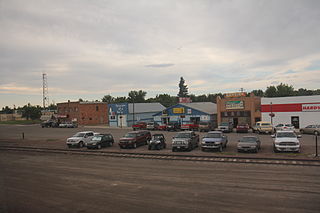
Harlem is a city in Blaine County, Montana, United States. The population was 769 at the 2020 census.

<span class="mw-page-title-main">Columbia Falls, Montana</span> City in Montana, United States

Columbia Falls is a city along the Flathead River in Flathead County, Montana, United States. The population was 5,308 at the 2020 census. Columbia Falls has been ranked as one of the best and safest places to live in Montana.

<span class="mw-page-title-main">Kalispell, Montana</span> City in Montana, United States

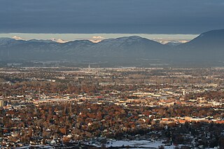
Kalispell is a city in Montana and the county seat of Flathead County, Montana, United States. The 2020 census put Kalispell's population at 24,558. In Montana's northwest region, it is the largest city and the commercial center of the Kalispell Micropolitan Statistical Area. The name Kalispell is a Salish word meaning "flat land above the lake".

<span class="mw-page-title-main">Whitefish, Montana</span> City in Montana, United States

Whitefish is a city in Flathead County, Montana, United States. According to the 2020 United States Census, there were 7,751 people in the city.

<span class="mw-page-title-main">Browning, Montana</span> Place in Montana, United States

Browning is a former town and current unincorporated community in Glacier County, Montana, United States. It is the headquarters for the Blackfeet Indian Reservation and was the only incorporated town on the Reservation. The population was 1,018 at the 2020 census.

<span class="mw-page-title-main">East Glacier Park Village, Montana</span> CDP in Montana, United States

East Glacier Park is an unincorporated community and census-designated place (CDP) in Glacier County, Montana, United States. As of the 2020 census, it had a population of 354.

<span class="mw-page-title-main">Gildford, Montana</span> Census-designated place in Montana, United States

Gildford is an unincorporated community and census-designated place (CDP) in Hill County, Montana, United States. The population was 179 at the 2010 census.

<span class="mw-page-title-main">Havre, Montana</span> City in Montana, United States

Havre is the county seat and largest city in Hill County, Montana, United States. Havre is nicknamed the crown jewel of the Hi-Line. It is said to be named after the city of Le Havre in France. As of the 2020 census the population was 9,362.

<span class="mw-page-title-main">Hingham, Montana</span> Town in Montana, United States

Hingham is a town in Hill County, Montana, United States. Its economy is largely agricultural. The population was 131 at the 2020 census.

<span class="mw-page-title-main">Inverness, Montana</span> CDP in Montana, United States

Inverness is a census-designated place (CDP) in Hill County, Montana, United States. The population was 55 at the 2010 census. It was named after a city in Scotland.

<span class="mw-page-title-main">Rudyard, Montana</span> Census-designated place in Montana, United States

Rudyard is an unincorporated community and census-designated place (CDP) in Hill County, Montana, United States. The population was 258 at the 2010 census.

<span class="mw-page-title-main">Chester, Montana</span> Town in Montana, United States

Chester is a town in and the county seat of Liberty County, Montana, United States. The population was 847 at the time of both the 2010 and 2020 U.S. Census.

<span class="mw-page-title-main">Saco, Montana</span> Town in Montana, United States

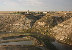
Saco is a town in Phillips County, Montana, United States. The population was 159 at the 2020 census.

<span class="mw-page-title-main">Valier, Montana</span> Town in Montana, United States

Valier is a town in Pondera County, Montana, United States. The population was 530 at the 2020 census.

<span class="mw-page-title-main">Culbertson, Montana</span> Town in Montana, United States

Culbertson is a town in Roosevelt County, Montana, United States. The population was 753 at the 2020 census.

<span class="mw-page-title-main">Shelby, Montana</span> City in Montana, United States

Shelby is a city in and the county seat of Toole County, Montana, United States. The population was 3,169 at the 2020 census.

<span class="mw-page-title-main">Joplin, Montana</span> Unincorporated community in Montana, United States

Joplin is an unincorporated community and census-designated place (CDP) in Liberty County, Montana, United States. The population was 157 at the 2010 census.

<span class="mw-page-title-main">Libby, Montana</span> City in Montana, United States

Libby is a city in northwestern Montana, United States and the county seat of Lincoln County. The population was 2,775 at the 2020 census.

References

  1. "ArcGIS REST Services Directory". United States Census Bureau. Retrieved September 5, 2022.
  2. "Find a County". National Association of Counties. Archived from the original on May 31, 2011. Retrieved June 7, 2011.
  3. 1 2 "U.S. Census website". United States Census Bureau . Retrieved November 2, 2021.
  4. "Cut Bank". Montana Place Names Companion. Montana Historical Society. Retrieved April 2, 2021.
  5. "US Gazetteer files 2010". United States Census Bureau. Archived from the original on January 25, 2012. Retrieved December 18, 2012.
  6. "NOWData - NOAA Online Weather Data". National Oceanic and Atmospheric Administration . Retrieved July 17, 2021.
  7. "Summary of Monthly Normals 19912020". National Oceanic and Atmospheric Administration . Retrieved July 17, 2021.
  8. "U.S. Climate Normals Quick Access – Station: Cut Bank Airport, MT (19812010)". National Oceanic and Atmospheric Administration. Retrieved December 31, 2022.
  9. Moffatt, Riley. Population History of Western U.S. Cities & Towns, 1850-1990. Lanham: Scarecrow, 1996, 129.
  10. "Census of Population and Housing". Census.gov. Retrieved July 16, 2016.
  11. "U.S. Census website". United States Census Bureau . Retrieved December 18, 2012.
  12. "Directory of Montana Schools". Montana Office of Public Instruction. March 13, 2024. p. 121-122/319. Retrieved March 13, 2024.
  13. "2020 CENSUS - SCHOOL DISTRICT REFERENCE MAP: Glacier County, MT" (PDF). U.S. Census Bureau. p. 3 (PDF p. 4/6). Retrieved March 13, 2024. - Text list
  14. "Cut Bank School District 15" . Retrieved April 12, 2021.
  15. "Member Schools". Montana High School Association. Retrieved April 19, 2021.
  16. "Montana Public Libraries". PublicLibraries.com. Retrieved June 14, 2019.
  17. "Home page". Cut Bank Pioneer Press. September 14, 2023. Retrieved January 3, 2024.
  18. "Cut Bank, Montana". Amtrak. Retrieved June 14, 2019.
  19. "CTB(KCTB) Cut Bank Intl". Federal Aviation Administration. Retrieved January 3, 2024.