Dajabón Airport

Last updated
Dajabón Airport
Summary
Airport type Public
Serves Dajabón, Dominican Republic
Elevation  AMSL 170 ft / 52 m
Coordinates 19°33′55″N71°40′30″W / 19.56528°N 71.67500°W / 19.56528; -71.67500 Coordinates: 19°33′55″N71°40′30″W / 19.56528°N 71.67500°W / 19.56528; -71.67500
Map
Dominican Republic location map.svg
Airplane silhouette.svg
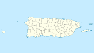
MDDJ
Location of the airport in the
Dominican Republic
Runways
Direction Length Surface
m ft
08/26 1,735 5,692 Grass
Source: GCM [1] Google Maps [2]

Dajabón National Airport is an airport that serves Dajabón, the capital of Dajabón Province in the western Dominican Republic. The airport is 4 kilometres (2.5 mi) east of the border with Haiti.

Dajabón Place in Dominican Republic

Dajabón is the capital city of the Dajabón province in the Dominican Republic, located on the border with Haiti. It is a market town with a population of about 40,000, north of the Cordillera Central mountain range.

Dajabón Province Province in Dominican Republic

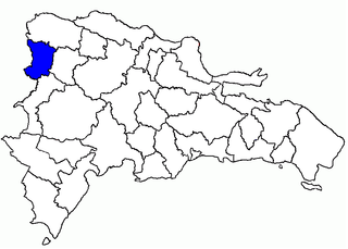
Dajabón is a province of the Dominican Republic, on the border with Haiti. Its capital city is also called Dajabón.

Dominican Republic country in the Caribbean

The Dominican Republic is a country located in the island of Hispaniola, in the Greater Antilles archipelago of the Caribbean region. It occupies the eastern five-eighths of the island, which it shares with the nation of Haiti, making Hispaniola one of two Caribbean islands, along with Saint Martin, that are shared by two sovereign states. The Dominican Republic is the second-largest Caribbean nation by area at 48,671 square kilometers (18,792 sq mi), and third by population with approximately 10 million people, of which approximately three million live in the metropolitan area of Santo Domingo, the capital city.

Contents

The Monte Cristi non-directional beacon (Ident: MTC) is located 18.1 nautical miles (33.5 km) north of the airport. The Cap Haitien VOR (Ident: HCN) is located 30.8 nautical miles (57.0 km) west-northwest of Dajabón Airport. [3] [4]

Non-directional beacon radio transmitter which emits radio waves in all directions

A non-directional (radio) beacon (NDB) is a radio transmitter at a known location, used as an aviation or marine navigational aid. As the name implies, the signal transmitted does not include inherent directional information, in contrast to other navigational aids such as low frequency radio range, VHF omnidirectional range (VOR) and TACAN. NDB signals follow the curvature of the Earth, so they can be received at much greater distances at lower altitudes, a major advantage over VOR. However, NDB signals are also affected more by atmospheric conditions, mountainous terrain, coastal refraction and electrical storms, particularly at long range.

VHF omnidirectional range

Very High Frequency (VHF) Omni-Directional Range (VOR) is a type of short-range radio navigation system for aircraft, enabling aircraft with a receiving unit to determine its position and stay on course by receiving radio signals transmitted by a network of fixed ground radio beacons. It uses frequencies in the very high frequency (VHF) band from 108.00 to 117.95 MHz. Developed in the United States beginning in 1937 and deployed by 1946, VOR is the standard air navigational system in the world, used by both commercial and general aviation. By 2000 there were about 3,000 VOR stations around the world including 1,033 in the US, reduced to 967 by 2013 with more stations being decommissioned with the widespread adoption of GPS.

See also

Related Research Articles

Kindu Airport airport

Kindu Airport is an airport serving the Lualaba River port of Kindu, Democratic Republic of the Congo.

Gbadolite Airport

Gbadolite Airport is an airport serving Gbadolite, the capital of the Nord-Ubangi Province in the Democratic Republic of the Congo. The airport is at the village of Moanda, 6 kilometres (3.7 mi) southwest of Gbadolite.

Constanza Airport airport in the Dominican Republic

Constanza National Airport is an airport for domestic flights serving Constanza, a town in the La Vega Province of the Dominican Republic.

Osvaldo Virgil Airport airport in the Dominican Republic

Osvaldo Virgil National Airport serves the province of Monte Cristi on the north coast of the Dominican Republic. This airport was opened in 2006 for tourism with flights from other Dominican airports. The runway is just north of the city.

Mobaye Mbanga Airport airport

Mobaye Mbanga Airport is an airport serving Mobaye, a town on the Ubangi River in the Basse-Kotto prefecture of the Central African Republic.

Cueva Las Maravillas Airport airport in the Dominican Republic

Cueva Las Maravillas Airport is an airport 13 kilometres (8 mi) east of San Pedro de Macorís, capital of the San Pedro de Macorís Province in the Dominican Republic. The airport was opened on February 7, 2008.

Azua Dominican Field airport in the Dominican Republic

Azua Dominica Airport is an airport 2 kilometres (1.2 mi) south of the city of Azua in the Azua Province of the Dominican Republic. It is an old airport that is used only for the emergency landing of domestic flights. This airport has never had regularly scheduled flights, although some airlines have operated charter or tourist flights here.

Angelina Field airport in the Dominican Republic

Angelina Airport is an agricultural airport 10 kilometres (6.2 mi) northwest of Cotuí, at the small town of El Pescozón in the Sánchez Ramírez Province of the Dominican Republic.

Enriquillo Field airport in the Dominican Republic

Juancho Enriquillo Airport is an agricultural airstrip 4 kilometres (2.5 mi) southwest of Enriquillo, a Caribbean coastal town in the Barahona Province of the Dominican Republic.

Esperanza Field airport in the Dominican Republic

Esperanza Airport or Peñuela Airport is an airport 2 kilometres (1.2 mi) east of Esperanza, a city in the Valverde Province of the Dominican Republic.

Baigua Field airport in the Dominican Republic

Baigua Airport was an agricultural airstrip near the hamlet of Baigue, in the La Altagracia Province of the Dominican Republic. Baigue is 7 kilometres (4.3 mi) southeast of Higüey.

Walterio Field airport in the Dominican Republic

Walterio Airport is a rural airport 10 kilometres (6.2 mi) south of the coastal city of Monte Cristi, Dominican Republic. It serves private aviation and air sports. Now with the Osvaldo Virgil Airport replacing most of its operations, this airport has been reverted as only a runway.

Los Montones Field airport in the Dominican Republic

Los Montones Airport is an airstrip 11 kilometres (7 mi) north of San Cristóbal, Dominican Republic.

San Isidro Air Base airport in the Dominican Republic

The Base Aérea de San Isidro or San Isidro Air Base became operational on March 23, 1953 and is located 25 km east of Santo Domingo. It was named Base Aérea Trujillo until 1961, when the name was changed to San Isidro. Most of the units, aircraft, and helicopters of the Dominican Air Force are based there.

Artigas Airport airport

Artigas International Airport is an airport serving Artigas, capital of the Artigas Province of Uruguay. The airport is 2 kilometres (1 mi) west of the city, and is close to the border with Brazil.

Mona Airport

Mona Airport is an airstrip on Mona Island, the third largest island of Puerto Rico. Private and commercial flights require a permit for use of the landing strip. The permit can only be acquired through the Puerto Rico Department of Natural and Environmental Resources. The airport is also available to planes for emergency purposes.

Tshaneni Airfield

Tshaneni Airfield is an airstrip serving Tshaneni, in Eswatini.

Campo Municipal de Aterrizaje Airport

Campo Municipal de Aterrizaje Airport is an airport serving the town of Minas in Lavalleja Department, Uruguay.

Placeres Airport

Placeres Airport is an airport serving the Uruguay River town of Bella Unión in Artigas Department, Uruguay. The airport is in the countryside 7 kilometres (4 mi) south-southeast of Bella Unión. There are 170 metres (560 ft) of unpaved overrun available on the northwest end.

Abbeyfeale Aerodrome

Abbeyfeale Aerodrome is an airport serving Abbeyfeale, a town in County Limerick in Ireland. The airport is 3 kilometres (2 mi) west-northwest of Abbeyfeale.

References

  1. Airport information for Dajabón Airport at Great Circle Mapper.
  2. "Dajabón Airport". Google Maps. Google. Retrieved 27 May 2018.
  3. Monte Cristi NDB
  4. Cap Haitien VOR

The Aviation Safety Network (ASN) is a website that keeps track of aviation accidents, incidents, and hijackings. Their database contains details of over 10,700 reports. The ASN includes an aviation database with aviation investigations, news, photos, and statistics.