Dalmarnock railway station

Last updated

The siding from the nearby rail yard to the gas works passed under the viaduct, above the current platform area, and across the Swanston Street level crossing. [4] All remnants have since been demolished. [5]

The low-level station closed on 5 October 1964 as a result of the Beeching Axe, but the station and tunnel remained intact.

1979 reopening

At the opening of the Argyle Line in November 1979, the station was served by six trains per hour on Mondays to Saturdays. in the westerly direction all went to Dalmuir, with three via Yoker and three via Singer. Two of these were extended to Dumbarton Central. In the easterly direction all trains travelled around the Hamilton Circle to Motherwell three in the clockwise direction passing through Bellshill prior to Motherwell and three passing through Hamilton Central first. The limited stop Milngavie to/from Lanark trains did not stop at Dalmarnock.

Station refurbishment

The station underwent a full revamp in time for the 2014 Commonwealth Games, being handy to the athletes' village and several venues. [6] Lifts were installed and a new street-level entrance and ticket office constructed along with landscaping aimed at better connecting the station environs to the nearby River Clyde and Glasgow Green. [7] The station was temporarily closed for renovation on 4 June 2012 and was scheduled to reopen in November 2012, [8] but the closure was extended to spring 2013 because of major problems over groundworks. The station reopened to passengers on 20 May 2013. [9]

Flooding

Record rainfalls have often led to flooding of the station and closure for a period of several hours in 1903, [10] two days in 1907, [11] [12] several hours in 1935 with water reaching platform height, [13] one day for the whole underground in 1938, [14] several weeks in 2002, several hours in 2017 (images), [15] several hours in 2019, [16] and two days in 2020. [17]

Services

Dalmarnock

Scottish Gaelic: Dail Meàrnaig [1]
National Rail logo.svg
Dalmarnock777.JPG
Dalmarnock station (pre-2014 refurbishment), looking towards the tunnel
General information
Location Dalmarnock, Glasgow
Scotland
Coordinates 55°50′33″N4°13′03″W / 55.8424°N 4.2176°W / 55.8424; -4.2176
Grid reference NS612631
Managed by ScotRail
Transit authority SPT
Platforms2
Other information
Station codeDAK
History
Original company Glasgow Central Railway
Pre-grouping Caledonian Railway
Post-grouping LMS
Key dates
1 November 1895 [2] Opened
5 October 1964 [2] Closed
5 November 1979 [2] Re-opened
3 June 2012Temporarily closed for refurbishment
23 May 2013Re-opened after refurbishment
Passengers
2018/19Decrease2.svg 0.414 million
Railways in the Parkhead area
BSicon CONTg.svg
BSicon exCONTg.svg
Alexandra Parade
BSicon dHST.svg
BSicon exdDST.svg
Kennyhill Goods
Haghill Goods
BSicon edDST.svg
BSicon exdSTR.svg
Duke Street
BSicon STRc2.svg
BSicon STR3.svg
BSicon lvHST@F-.svg
BSicon exSTRl.svg
BSicon exKRZo.svg
BSicon exSTR2+r.svg
BSicon exSTRc3.svg
Haghill Junction
(CB NBR) Camlachie Goods
Coatbridge Branch (NBR) Arrow Blue Left 001.svg 
BSicon dCONTgq.svg
BSicon ABZq1.svg
BSicon STRq.svg
BSicon cSTRc4.svg
BSicon edDSTq.svg
BSicon eKRZq2u.svg
BSicon exSTRc13.svg
BSicon eHSTq.svg
BSicon eABZq+4.svg
BSicon dCONTfq.svg
BSicon tdCONTgq.svg
BSicon lBHFc2.svg
BSicon tSTR2+r.svg
BSicon lBHFc3.svg
BSicon exSTRc1.svg
BSicon exSTRc2.svg
BSicon exSTR+4.svg
BSicon exENDE3.svg
Parkhead Forge Siding (SB CR)
(GCR)
Bridgeton
BSicon lBHFc1.svg
BSicon lBHFc4.svg
BSicon tABZ4+fxl.svg
BSicon extSTR2+r.svg
BSicon extSTRc3.svg
BSicon exABZg+1.svg
BSicon exSTRc4.svg
Parkhead Forge Junction
BSicon tSTR.svg
BSicon exd-KDST2.svg
BSicon exSTRc3.svg
BSicon exKRZ2+4t.svg
BSicon extSTRc3.svg
London Road Goods
BSicon tSTR.svg
BSicon exSTRc12.svg
BSicon extSTRc1.svg
BSicon exABZ3+4g.svg
BSicon extSTR+4.svg
London Road Junction
(GCR)
Dalmarnock
BSicon tSTRe.svg
BSicon exSTRc2.svg
BSicon lHST.svg
BSicon exHST3+1.svg
BSicon exSTRc4.svg
BSicon extSTR.svg
Dalmarnock
Strathclyde Junction
BSicon eABZg+1.svg
BSicon exSTRc4.svg
BSicon extSTR.svg
(GCR)
Bridgeton Goods
BSicon eABZg+l.svg
BSicon excSTRq.svg
BSicon exdKDSTeq.svg
BSicon extHST2.svg
BSicon extdSTRc3.svg
Parkhead Stadium
(GCR)
BSicon hbKRZWae.svg
BSicon extdSTRc1.svg
BSicon extCONT4.svg
BSicon CONTf.svg
Railways
CB NBR
Coatbridge Branch (NBR)
CoGUR
City of Glasgow Union Railway (Joint G&SWR and NBR)
GCR
Glasgow Central Railway (CR)
SB CR
The Switchback (CR)
Passenger trains per hour [18]
DirectionTerminusViaMon–SatSun (10am–6pm)
Eastbound Cumbernauld Motherwell, Airbles 1
Motherwell Hamilton Central or Whifflet 23
Larkhall Hamilton Central 21
Whifflet 1
Westbound Dalmuir Yoker or Singer 2
Milngavie 22
Balloch 22
Preceding station National Rail logo.svg National Rail Following station
Rutherglen   ScotRail
Argyle Line
  Bridgeton
  Historical railways  
Rutherglen   Caledonian Railway
Glasgow Central Railway
  Bridgeton Cross
Rutherglen   Caledonian Railway
London Road branch
 London Road

Footnotes

  1. Brailsford 2017, Gaelic/English Station Index.
  2. 1 2 3 4 Butt (1995), page 76
  3. Bradshaw's Railway Manual, 1881 , p. 38, at Google Books
  4. "Glasgow map, 1954". www.maps.nls.uk.
  5. "Dalmarnock Road viaduct, 2008". www.google.co.uk.
  6. "Revamp funding for Game station". BBC. 4 May 2010. Retrieved 26 May 2011.
  7. Diagonal - Glasgow, UK, Sheppard Robson
  8. "Dalmarnock Redevelopment". ScotRail. Archived from the original on 5 June 2012. Retrieved 24 June 2012.
  9. "Station reopens after delay to £11m rebuild". Herald Scotland. 21 May 2013. Retrieved 21 May 2013.
  10. "Scotsman, 10 Feb 1903". www.randomscottishhistory.com. p. 5.
  11. "Glasgow Herald, 17 Oct 1907". www.news.google.com. p. 6.
  12. "Glasgow Herald, 18 Oct 1907". www.news.google.com. p. 6.
  13. "Glasgow Herald, 25 Jun 1935". www.news.google.com. p. 11.
  14. "Glasgow Herald, 29 Jul 1938". www.news.google.com. p. 6.
  15. "Flooding at Dalmarnock Station, 13 May 2017". www.railforums.co.uk.
  16. "Herald Scotland, 11 Aug 2019". www.heraldscotland.com.
  17. "Inews, 16 Feb 2020". www.inews.co.uk.
  18. "May 2020 NRT: Tables 225 & 226". www.networkrail.co.uk.

Related Research Articles

<span class="mw-page-title-main">Dalmuir railway station</span> Railway station in West Dunbartonshire, Scotland

Dalmuir railway station is a railway station serving the Dalmuir area of Clydebank, West Dunbartonshire, Scotland. It is a large, five-platform interchange between the Argyle Line, North Clyde Line and West Highland Line.

<span class="mw-page-title-main">Clydebank railway station</span> Railway station in West Dunbartonshire, Scotland

Clydebank railway station is a railway station serving the town of Clydebank in West Dunbartonshire, Scotland. It is located on the Argyle Line and the North Clyde Line. Passenger services are operated by ScotRail.

<span class="mw-page-title-main">Argyle Street railway station</span> Railway station in Glasgow, Scotland

Argyle Street railway station is a station in the City Centre of Glasgow, Scotland, on the Argyle Line, which connects the North Clyde lines at Partick with Rutherglen in the south-east of the city. The station is located below the thoroughfare whose name it bears. It has a narrow and often crowded island platform. It serves the Argyle Street shopping precinct as well as the St Enoch Centre. The station is open all day Monday to Saturdays but is only open between 10am and 6pm on a Sunday so this is worth keeping in mind if using the station on a Sunday

<span class="mw-page-title-main">Langside railway station</span> Railway station in Glasgow, Scotland

Langside railway station is a railway station that serves the Langside and Newlands area of Glasgow, Scotland. It is located on the Cathcart Circle Line. Services are provided by ScotRail on behalf of Strathclyde Partnership for Transport.

<span class="mw-page-title-main">Anniesland railway station</span> Railway station in Glasgow, Scotland

Anniesland railway station is a railway station that serves the Anniesland suburb of Glasgow, Scotland.

<span class="mw-page-title-main">Westerton railway station</span> Railway station in East Dunbartonshire, Scotland

Westerton railway station is a railway station that serves the Westerton district in the town of Bearsden, Scotland. The station is managed and served by ScotRail as part of the Strathclyde Partnership for Transport network. It is located on the Argyle and North Clyde lines, between Drumchapel to the west, Bearsden to the north, and Anniesland and Maryhill to the south-east. It is 6 miles 10 chains (9.9 km) west of Glasgow Queen Street, measured via Maryhill.

<span class="mw-page-title-main">Cambuslang railway station</span> Railway station in South Lanarkshire, Scotland

Cambuslang railway station is a railway station which serves the town of Cambuslang, South Lanarkshire, Scotland. The station is 5 miles (8 km) south east of Glasgow Central, and is regularly served by trains on the Argyle Line to and from Glasgow Central. Passenger services are provided by ScotRail on behalf of Strathclyde Partnership for Transport (SPT).

<span class="mw-page-title-main">Uddingston railway station</span> Railway station in South Lanarkshire, Scotland

Uddingston railway station serves the town of Uddingston, South Lanarkshire, Scotland. ScotRail provides passenger services to this station on the Argyle Line and Shotts Line.

<span class="mw-page-title-main">Rutherglen railway station</span> Railway station in South Lanarkshire, Scotland

Rutherglen railway station is in the town centre of Rutherglen, South Lanarkshire, Scotland, and lies on the Argyle Line. The station is served by a single island platform, connected to the street by a footbridge.

<span class="mw-page-title-main">Carmyle railway station</span> Railway station in Glasgow, Scotland

Carmyle railway station is located in the Carmyle area of Glasgow. It is on the Whifflet Line, 5.5 miles (8.9 km) east of Glasgow Central railway station. Services are provided by ScotRail.

<span class="mw-page-title-main">Mount Vernon railway station</span> Railway station in Glasgow, Scotland

Mount Vernon railway station is a railway station located in the Mount Vernon area of Glasgow, Scotland. It is on the Whifflet Line, 6+34 miles (10.9 km) east of Glasgow Central. Train services are provided by ScotRail.

<span class="mw-page-title-main">Coatbridge Central railway station</span> Railway station in North Lanarkshire, Scotland

Coatbridge Central railway station is a station in Coatbridge, North Lanarkshire, Scotland. It is on the Argyle Line. Train services are provided by ScotRail.

<span class="mw-page-title-main">Partick station</span> Glasgow subway and railway station

Partick is an interchange station in the Partick area of Glasgow, Scotland. Along with the adjacent bus station, it forms one of the main transport hubs in Glasgow. As of 2022, it is the fifth-busiest station in Scotland. The station is served by Glasgow Subway and ScotRail services and was one of the first to receive bilingual English and Gaelic signs, due to the significant Gaelic-speaking population in the surrounding Partick area.

<span class="mw-page-title-main">Bridgeton railway station</span> Railway station in Glasgow, Scotland

Bridgeton railway station serves the Bridgeton district of Glasgow, Scotland and is a station on the Argyle Line, 1+34 miles (2.8 km) south east of Glasgow Central. The station is operated by ScotRail who also provide all train services.

<span class="mw-page-title-main">Scotstounhill railway station</span> Railway station in Glasgow, Scotland

Scotstounhill railway station serves Scotstounhill in Glasgow, Scotland. The station lies on the Argyle and North Clyde lines, serving the districts of Scotstoun and Knightswood, with trains to and from Glasgow Central or Queen Street stations and on into the east end.

<span class="mw-page-title-main">Drumchapel railway station</span> Railway station in Glasgow, Scotland

Drumchapel railway station serves the Drumchapel, Blairdardie and Old Drumchapel areas of Glasgow, Scotland. The station is managed by ScotRail and is served by trains on the Argyle Line and North Clyde Line.

<span class="mw-page-title-main">Kirkhill railway station</span> Railway station in South Lanarkshire, Scotland

Kirkhill railway station is a railway station serving the Kirkhill area of the town of Cambuslang, South Lanarkshire, Greater Glasgow, Scotland. The station is managed by ScotRail and is located on the Newton Line. This is the least used station on the Newton Branch.

<span class="mw-page-title-main">Burnside railway station</span> Railway station in South Lanarkshire, Scotland

Burnside railway station serves the Burnside and Blairbeth areas of the Royal Burgh of Rutherglen, South Lanarkshire, Greater Glasgow, Scotland. The station is managed by ScotRail and is located on the Newton branch of the Cathcart Circle Lines, which has been electrified since 1962 by British Railways. This is the busiest railway station on the Newton branch.

<span class="mw-page-title-main">Kilpatrick railway station</span> Railway station in West Dunbartonshire, Scotland

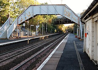
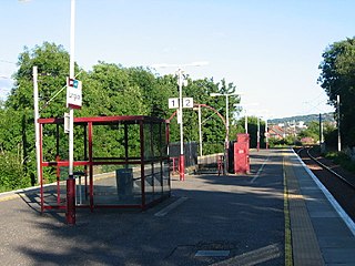
Kilpatrick railway station serves the village of Old Kilpatrick in the West Dunbartonshire region of Scotland. The station is managed by ScotRail and is on the North Clyde Line, 1112 miles (18 km) west of Glasgow and the Argyle Line on Sundays.

The Switchback was a railway line in the East End of Glasgow, Scotland, constructed by the Caledonian Railway (CR). Connecting the lines at Rutherglen on the south side of the city with Robroyston on the north side, this route also served a number of industrial sidings and rail yards.

References