Dalton, Pennsylvania

Last updated
Dalton, Pennsylvania
USPS Dalton PA 18414.jpg
Dalton post office
Lackawanna County Pennsylvania Incorporated and Unincorporated areas Dalton Highlighted.svg
Location of Dalton in Lackawanna County, Pennsylvania
USA Pennsylvania location map.svg
Red pog.svg
Dalton
Location in Pennsylvania
Usa edcp location map.svg
Red pog.svg
Dalton
Location in the United States
Coordinates: 41°32′08″N75°44′06″W / 41.53556°N 75.73500°W / 41.53556; -75.73500
CountryUnited States
StatePennsylvania
County Lackawanna
Government
  MayorAaron Holzman
Area
[1]
  Total3.07 sq mi (7.96 km2)
  Land3.02 sq mi (7.82 km2)
  Water0.06 sq mi (0.14 km2)
Elevation
991 ft (302 m)
Population
 (2020) [2]
  Total1,284
  Density425.31/sq mi (164.19/km2)
Time zone UTC-5 (EST)
  Summer (DST) UTC-4 (EDT)
Zip Code
18414
Area code 570
FIPS code 42-18088
Website daltonboro.com

Dalton is a borough in Lackawanna County, Pennsylvania, United States. It is part of Northeastern Pennsylvania and is located approximately eight miles north of the city of Scranton in a suburban area known as "the Abingtons." Dalton is also approximately three miles north of Clarks Summit, the hub of the Abington community. The population was 1,283 at the 2020 census. [3]

Contents

Geography

Dalton is located at 41°32′8″N75°44′6″W / 41.53556°N 75.73500°W / 41.53556; -75.73500 (41.535597, -75.735090). [4] According to the U.S. Census Bureau, the borough has a total area of 3.2 square miles (8.3 km2), of which 3.1 square miles (8.0 km2) is land and 0.1 square miles (0.26 km2) 1.90% is water.

Demographics

Historical population
CensusPop.Note
1880 172
1900 681
1910 76712.6%
1920 7862.5%
1930 1,07236.4%
1940 1,0901.7%
1950 1,1091.7%
1960 1,22710.6%
1970 1,2824.5%
1980 1,3837.9%
1990 1,369−1.0%
2000 1,294−5.5%
2010 1,234−4.6%
2020 1,2834.0%
2021 (est.)1,279 [3] −0.3%
Sources: [5] [6] [7] [8] [2]

At the 2000 census there were 1,234 people, 502 households, and 357 families residing in the borough. The population density was 398.1 inhabitants per square mile (153.7/km2). There were 547 housing units at an average density of 176.5 units per square mile (68.1 units/km2). The racial makeup of the borough was 97.6% White, 0.1% Black, 0.2% American Indian, 1.3% Asian, and 0.8% from two or more races. Hispanic or Latino of any race were 1%. [6]

There were 502 households, 28.9% had children under the age of 18 living with them, 60.8% were married couples living together, 7.6% had a female householder with no husband present, and 28.9% were non-families. 25.1% of households were made up of individuals, and 12.4% were one person aged 65 or older. The average household size was 2.46 and the average family size was 2.96.

In the borough the population was spread out, with 21.9% under the age of 18, 61.1% from 18 to 64, and 17% 65 or older. The median age was 45.5 years.

The median household income was in the borough was $47,625. The median family income in the borough was $65,577. Males had a median income of $41,964 versus $30,583 for females. The per capita income for the borough was $25,760. About 5.0% of families and 6.9% of the population were below the poverty line, including 8.8% of those under age 18 and 7.1% of those age 65 or over.

Notable places

Dalton is noted for having many business and community services centered in its downtown strip. Along Main Street in a small 0.1 mile location are located a fire station, police office, pizzeria, pub and eatery, library, pharmacy, and post office. Dalton was also the home to the Dalton House, which was part of the National Register of Historic Places. The building was torn down in the 1990s.

Twin town

Dalton is twinned with:

Related Research Articles

<span class="mw-page-title-main">Waverly Township, Pennsylvania</span> Township in Pennsylvania, United States

Waverly Township is a township in Lackawanna County, Pennsylvania, United States. It is bordered by Dalton and Glenburn townships to the west, North Abington Township to the north, the boroughs of Clarks Summit and Clarks Green to the south, and South Abington Township to the south and southeast. Waverly Township is part of a suburban area known as "the Abingtons". The population was 1,861 at the 2020 census.

<span class="mw-page-title-main">Clarks Green, Pennsylvania</span> Borough in Pennsylvania, United States

Clarks Green is a borough in Lackawanna County, Pennsylvania, United States. It is part of Northeastern Pennsylvania. The population was 1,529 at the 2020 census.

<span class="mw-page-title-main">Clarks Summit, Pennsylvania</span> Borough in Pennsylvania, United States

Clarks Summit is a borough in Lackawanna County, northwest of Scranton in Northeastern Pennsylvania. The population was 5,108 at the 2020 census. It is also the northern control city of the Pennsylvania Turnpike Northeast Extension, I-476, though the official terminus is in adjacent South Abington Township.

Glenburn is a census-designated place (CDP) in Glenburn Township, Lackawanna County, Pennsylvania, United States. The population was 953 at the 2010 census. It is approximately 10 miles (16 km) north of downtown Scranton, in the growing suburban area known as the "Abingtons". Glenburn is located north of Clarks Summit and south of Dalton.

<span class="mw-page-title-main">Jessup, Pennsylvania</span> Borough in Pennsylvania, United States

Jessup is a borough in Lackawanna County, Pennsylvania, United States. The population was 4,532 at the 2020 census.

<span class="mw-page-title-main">North Abington Township, Lackawanna County, Pennsylvania</span> Place in Pennsylvania, United States

North Abington Township is a township in Lackawanna County, Pennsylvania, United States. It is located approximately 10 miles (16 km) north of Scranton, Pennsylvania, and is located in the suburban area known as “the Abingtons". North Abington is also approximately 6 miles (10 km) north of Clarks Summit and borders Waverly Township and Dalton Borough to the south, as well as Benton Township to the north. The population was 709 at the 2020 census.

<span class="mw-page-title-main">Taylor, Pennsylvania</span> Borough in Pennsylvania, United States

Taylor is a borough in Lackawanna County, Pennsylvania, United States, 3 miles (5 km) southwest of Scranton on the Lackawanna River. It was founded in 1790 by Cornelius Atherton. Silk manufacturing and coal mining were once practiced in the borough. Most of Taylor is built over abandoned mines. The Pennsylvania Turnpike Northeast Extension (I-476), accessible via the Keyser Avenue Interchange, passes through Taylor, going north to Clarks Summit and south to Philadelphia.

<span class="mw-page-title-main">Bear Creek Village, Pennsylvania</span> Borough in Pennsylvania, United States

Bear Creek Village is a borough in Luzerne County, Pennsylvania, United States. The population was 290 at the 2020 census.

<span class="mw-page-title-main">Edwardsville, Pennsylvania</span> Borough in Pennsylvania, United States

Edwardsville is a borough in Luzerne County, Pennsylvania, United States. The population was 4,918 at the 2020 census.

<span class="mw-page-title-main">Luzerne, Pennsylvania</span> Borough in Pennsylvania, United States

Luzerne is a borough located 5 miles (8 km) north of Wilkes Barre in Luzerne County, Pennsylvania, United States.

<span class="mw-page-title-main">Pringle, Pennsylvania</span> Borough in Pennsylvania, United States

Pringle is a borough in Luzerne County, Pennsylvania, United States. As of the 2020 census, the borough population was eight hundred and ninety-one.

<span class="mw-page-title-main">Yatesville, Pennsylvania</span> Borough in Pennsylvania, United States

Yatesville is a borough in the Greater Pittston area of Luzerne County, Pennsylvania. The population was 638 as of the 2020 census.

<span class="mw-page-title-main">Lanesboro, Pennsylvania</span> Borough in Pennsylvania, United States

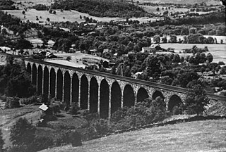
Lanesboro is a borough in Susquehanna County, Pennsylvania, United States. The population was 485 at the 2020 census.

<span class="mw-page-title-main">New Milford, Pennsylvania</span> Borough in Pennsylvania, United States

New Milford is a borough in Susquehanna County, Pennsylvania, United States. The population was 817 at the 2020 census. Children living in New Milford are served by the schools in the Blue Ridge School District, including Blue Ridge High School.

<span class="mw-page-title-main">Oakland, Susquehanna County, Pennsylvania</span> Borough in Pennsylvania, United States

Oakland is a borough in Susquehanna County, Pennsylvania, United States. The population of Oakland borough was 564 at the 2020 census.

<span class="mw-page-title-main">Thompson, Pennsylvania</span> Borough in Pennsylvania, United States

Thompson is a borough in Susquehanna County, Pennsylvania, United States. The population was 255 at the 2020 census.

<span class="mw-page-title-main">Union Dale, Pennsylvania</span> Borough in Pennsylvania, United States

Union Dale is a borough in Susquehanna County, Pennsylvania, United States. The borough was incorporated in 1885. Union Dale's population was 267 at the 2010 census.

<span class="mw-page-title-main">Prompton, Pennsylvania</span> Borough in Pennsylvania, United States

Prompton is a borough that is located in Wayne County, Pennsylvania, United States. The population was 250 at the time of the 2010 census.

<span class="mw-page-title-main">Waymart, Pennsylvania</span> Borough in Pennsylvania, United States

Waymart is a borough in Wayne County, Pennsylvania, United States. The borough's population was 1,341 at the time of the 2010 United States Census.

<span class="mw-page-title-main">North Berwick (CDP), Maine</span> Census-designated place in Maine, United States

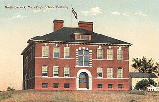
North Berwick is a census-designated place (CDP) consisting of the primary settlement in the town of North Berwick in York County, Maine, United States. The population was 1,615 at the 2010 census, out of a total town population of 4,576. It is part of the Portland–South Portland–Biddeford, Maine Metropolitan Statistical Area.

References

  1. "ArcGIS REST Services Directory". United States Census Bureau. Retrieved October 12, 2022.
  2. 1 2 "Census Population API". United States Census Bureau. Retrieved Oct 12, 2022.
  3. 1 2 Bureau, US Census. "City and Town Population Totals: 2020—2021". Census.gov. US Census Bureau. Retrieved August 5, 2022.
  4. "US Gazetteer files: 2010, 2000, and 1990". United States Census Bureau. 2011-02-12. Retrieved 2011-04-23.
  5. "Census of Population and Housing". U.S. Census Bureau. Retrieved 11 December 2013.
  6. 1 2 "U.S. Census website". United States Census Bureau . Retrieved 2008-01-31.
  7. "Incorporated Places and Minor Civil Divisions Datasets: Subcounty Resident Population Estimates: April 1, 2010 to July 1, 2012". Population Estimates. U.S. Census Bureau. Archived from the original on June 11, 2013. Retrieved 11 December 2013.
  8. "Census of Population and Housing". Census.gov. Retrieved June 4, 2016.