Dantewada district

Last updated
Dantewada district
Danteswari Temple 0034.jpg
Dantewada in Chhattisgarh (India).svg
Location in Chhattisgarh
Dantewada district
Dantewada district
CountryFlag of India.svg  India
State Chhattisgarh
Division Bastar
Headquarters Dantewada
Tehsils 5
Government
   Vidhan Sabha constituencies 1
Area
  Total3,410.50 km2 (1,316.80 sq mi)
Population
 (2011)
  Total283,479
  Density83/km2 (220/sq mi)
Demographics
   Literacy 42.12 per cent
Time zone UTC+05:30 (IST)
Website dantewada.nic.in

Dantewada District, also known as Dantewara District or Dakshin Bastar District (South Bastar District), is a district in the Indian state of Chhattisgarh. Dantewada is the district headquarters. The district is part of Bastar Division. Until 1998, Dantewada District was a tehsil of the larger Bastar District.

Contents

As of 2011 it is the third least populous district of Chhattisgarh (out of 18), after Narayanpur and Bijapur. [1]

The present collector of Dantewada is Shri Deepak Soni. [2]

History

Before Indian Independence, the district was part of the princely state of Bastar. After Independence in 1947, Bastar's ruler acceded to the government of India, and the erstwhile state became part of Bastar District of Madhya Pradesh state. Bastar District was divided into the districts of Bastar, Dantewada, and Kanker in 1998. In 2000, Dantewada was one of the 16 Madhya Pradesh districts that constituted the new state of Chhattisgarh. Dantewada was bifurcated in 2007, resulting in a new district Bijapur district, Chhattisgarh with four tehsils: Bijapur, Bhairamgarh, Usoor and Bhopalpatnam. It was further bifurcated in 2012, resulting in another new district, Sukma, with three tehsils: Chhindgarh, Sukma and Konta. In Ramayana this region considered as Dandakaranya .

Maoist terrorism

The district is currently a part of the Red Corridor. [3] Over the last year,[ when? ] more than 350 people have been killed and 50,000 moved into camps in the Dantewada district, as a result of a Maoist uprising.

In April 2010, the Maoist terrorists killed at least 75 Indian soldiers in a series of attacks on security convoys in Dantewada. [4] In May 2010, the Naxals targeted the Special Police Officers traveling in a civilian bus, killing around 31, [5] to 44, [6] including several Special Police Officers and civilians. [7]

Education

Dantewada is the worst affected Maoist region, but the students still managed to perform well in their high-school board examinations. In 2017, their pass percentage crossed 80 for the first time, making Dantewada the best performing district on the board exam. [8]

The average literacy rate of Dantewada (Dantewara) district is 42.12 percent.

Dantewada received the Prime Minister's award for converting Palnar into a cashless village. [9] After the November 8 demonetization of high-value notes, The then district collector Saurabh Kumar and his team managed to procure fiber and bandwidth from Essar Steel under its corporate social responsibility to create a free wi-fi zone of two and half square km area to kick-start digital payments in the village market that houses 14 shops. [10]

Educational Institutes

1- Government Danteshwari PG College Dantewada

http://www.pgcollegedantewada.com

2. College of Agriculture, Chitalanka, Dantewada

3. Kendriya Vidyalaya (KV), Dantewada

http://www.kvdantewada.com/home.php

4.Jawahar Navodaya Vidyalaya, Barsoor, Dantewada

http://www.jnvbarsoor.in

5. Govt Model Higher Secondary School, Dantewada

6. NMDC Polytechnic College Dantewada

http://nmdcdavpoly.in

Geography

Dantewada District has an area of 3,410.50 km².

Encompassing with hilly tracks, dales and valleys, numerous brooks and rivers, and many forests, Dantewada is home to many species of wildlife such as the tiger, leopard, deer, bison, etc. Two species characteristic to the area are the pahadi maina and the Wild Asian Water buffalo.

Dantewada District's culture represents a unique blend of influences of Tribal, Chhattisgarhi, Oriya, Telugu & Marathi culture.

Administrative divisions

Dantewada district is divided into five tehsils, and four "development blocks". It is further divided into 143 gram panchayats. [11] The five tehsils are: [12]

Demographics

Religions in Dantewada district (2011) [14]
ReligionPercent
Hinduism
96.92%
Christianity
1.19%
Islam
1.19%
Other or not stated
0.70%

According to the 2011 census the undivided Dantewada district had a population of 533,638, [1] roughly equal to the nation of Cape Verde. [15] This gives it a ranking of 540th in India (out of a total of 640). [1] The district has a population density of 45 inhabitants per square kilometre (120/sq mi) . [1] Its population growth rate over the decade 2001-2011 was 15.56%. [1] Dantewada has a sex ratio of 1016 females for every 1000 males, [1] and a literacy rate of 42.27%. [1]

After the separation of Sukma district, the residual district has a population of 283,479, of which 68,031 (24.00%) live in urban areas. Dantewada has a sex ratio of 1023 females per 1000 males and a literacy rate of 42.12%. Scheduled Castes and Scheduled Tribes make up 3.61% and 71.07% of the district's population. The district is divided into five tehsils, Dantewada, Gidam, Kuwakonda Katekalyan, and Bade Bacheli.

Languages of Dantewada district (2011) [16]

   Gondi (60.14%)
   Halbi (17.79%)
   Hindi (9.50%)
   Chhattisgarhi (4.26%)
   Odia (1.98%)
   Bengali (1.81%)
   Telugu (1.17%)
  Others (3.35%)

At the time of the 2011 Census of India in the divided district, 60.14% of the population in the district spoke Gondi, 17.79% Halbi, 9.50% Hindi, 4.26% Chhattisgarhi, 1.98% Odia, 1.81% Bengali and 1.17% Telugu as their first language. [16]

Related Research Articles

<span class="mw-page-title-main">Gadchiroli district</span> District of Maharashtra in India

Gadchiroli district is an administrative district in Maharashtra, India. The city of Gadchiroli is the administrative headquarters of the district.

<span class="mw-page-title-main">Bastar district</span> District of Chhattisgarh in India

Bastar is a district in the state of Chhattisgarh in Central India. Jagdalpur is the district headquarters. Bastar is bounded on the northwest by Narayanpur District, on the north by Kondagaon district, on the east by Nabarangpur and Koraput Districts of Odisha State, on the south and southwest by Dantewada and Sukma. The district possesses a unique blend of tribal and Odia culture.

<span class="mw-page-title-main">Mahendra Karma</span> Indian politician

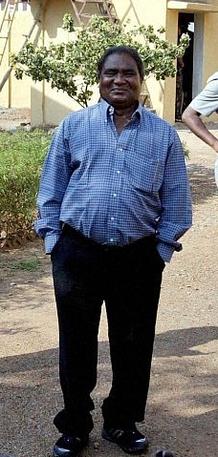
Mahendra Karma was an Indian political leader belonging to Indian National Congress from Chhattisgarh. He was the leader of the opposition in the Chhattisgarh Vidhan Sabha from 2004 to 2008. In 2005, he played a top role in organising the Salwa Judum movement against Naxalites, a Maoist group in Chhattisgarh. He was a Minister of Industry and Commerce in the Ajit Jogi cabinet since the state formation in 2000 to 2004. He was assassinated by Naxalites on 25 May 2013 in the 2013 Naxal attack in Darbha valley while returning from a Parivartan Rally meeting organised by his party in Sukma.

<span class="mw-page-title-main">Dindori district</span> District of Madhya Pradesh in India

Dindori District, formerly known as Ramgarh District, is a district of Madhya Pradesh state of central India. The town of Dindori is the district headquarters. The district is part of Jabalpur Division. Total area of the district is 6,128 km2 (2,366 sq mi). It is located on the eastern part of Madhya Pradesh, bordering the state of Chhattisgarh. It is surrounded by Anuppur district to the northeast, Umaria district to the north, Jabalpur district to the west, Mandla district to the southwest and Mungeli and Kabirdham districts of Chhattisgarh to the south.

<span class="mw-page-title-main">Jashpur district</span> District of Chhattisgarh in India

Jashpur District is a district of the central Indian state of Chhattisgarh bordering Jharkhand and Odisha. Jashpur Nagar is the administrative headquarters of the district. The district was formerly a princely state before Independence. Highly mountainous and forested, Jashpur is known for its natural environment.

Dantewada is a town and a municipality, or nagar palika. in the Dantewada district in the state of Chhattisgarh, India.It is the administrative headquarters of Dantewada District. It is the fourth largest city of Bastar division. The town is named after the goddess Danteshwari, the presiding deity of the Danteshwari Temple located in the town, 80 km from the Jagdalpur town. The goddess is worshipped as an incarnation of Shakti and the temple is held to be one of the fifty-two sacred Shakti Peethas. Dantewada Town is well connected by broad gauge railway line from Visakhapatnam. The Nearest Big city to Dantewada is Raipur and well connected with Bus services

<span class="mw-page-title-main">Bastar division</span> Administrative division of Chhattisgarh State, India

Bastar division is an administrative division of Chhattisgarh state in central India. It includes the districts of Bastar, Dantewada, Bijapur, Narayanpur, Sukma, Kondagaon and Kanker.

The April 2010 Dantewada Maoist attack was an 6 April 2010 ambush by Naxalite-Maoist insurgents from the Communist Party of India (Maoist) near Chintalnar village in Dantewada district, Chhattisgarh, India, leading to the killing of 76 CRPF policemen and 8 Maoists — the deadliest attack by the Maoists on Indian security forces.

<span class="mw-page-title-main">Bijapur district, Chhattisgarh</span> District of Chhattisgarh in India

Bijapur District, formerly known as Birjapur, is one of the 27 districts of the state of Chhattisgarh in central India. It is one of the two new districts created on May 11, 2007. As of 2011 it is the second least populous district of Chhattisgarh, after Narayanpur. It is the second-least literate district in India, with a literacy rate of at 41.58%, according to the 2011 census.

<span class="mw-page-title-main">Narayanpur district</span> District of Chhattisgarh in India

Narayanpur district is one of the 33 districts of Chhattisgarh State in Central India. It is one of the two districts created on May 11, 2007. It was carved out from the erstwhile Bastar district. This district occupies an area of 6640 km2 and it had a population of 110,800 in 2001. Narayanpur town is the administrative headquarters of this district. This district comprises 366 villages. It is currently a part of the Red Corridor.

<span class="mw-page-title-main">Chhattisgarh Police</span> State Police force in India

The Chhattisgarh Police is the law enforcement agency for the state of Chhattisgarh in India. The agency is administered by the Department of Home Affairs of the Government of Chhattisgarh. The force has specialized units to fight the Naxalite–Maoist insurgency in some districts of the state.

<span class="mw-page-title-main">Soni Sori</span> Indian activist and prisoner

Soni Sori is an Adivasi school teacher turned political leader of Aam Aadmi Party in Sameli village of Dantewada in south Bastar, Chhattisgarh, India. She was arrested by the Delhi Police's Crime Branch for Chhattisgarh Police in 2011 on charges of acting as a conduit for Maoists. During her imprisonment, she was tortured and sexually assaulted by Chhattisgarh state police. By April 2013, the Indian Courts had acquitted her in six of the eight cases filed against her due to lack of evidence. After release from prison, Sori began campaigning for the rights of those caught up in the conflict between Maoist insurgents and the government, in particular criticising police violence against tribespeople in the region.

<span class="mw-page-title-main">Mungeli district</span> District of Chhattisgarh in India

Mungeli district is a district of Chhattisgarh, India, with headquarters in Mungeli. It was carved out of Bilaspur district in 2013. The present collector of Mungeli is Shri Rahul Dev.

<span class="mw-page-title-main">Sukma district</span> District of Chhattisgarh in India

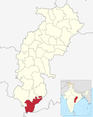
Sukma district is the southernmost district in the Indian state of Chhattisgarh. It is located in the Bastar region, known for its tribal culture. Sukma district borders with Odisha, Telangana and Andhra Pradesh.

<span class="mw-page-title-main">Kondagaon district</span> District of Chhattisgarh in India

Kondagaon district is a district of Chhattisgarh, India, and separated from Bastar district on 24 January 2012. with headquarters in Kondagaon. It is mostly renowned for its bell metal craft and other art forms native to the tribal of Bastar. It is also known as the Shilp sheher of Chhattisgarh owing to the variety of indigenous crafts produced in the area.

The Sukma attack was an ambush carried out by the Communist Party of India (Maoist) against Indian paramilitary forces on 24 April 2017, during the Naxalite-Maoist insurgency. It was the largest ambush since a similar attack in 2010, in the neighbouring district of Dantewada.

Palnar is a village positioned in Kuwakonda Block of Dantewada district in Chhattisgarh. Located in rural area of Dantewada district of Chhattisgarh, it is one among the 54 villages of Kuwakonda Block of Dantewada district. As per the government records, the village code of Palnar is 450279. The village has 432 houses.

Bhima Mandavi was a Bharatiya Janata Party politician and member of the Chhattisgarh Legislative Assembly from Dantewada assembly constituency.

Madvi Hidma is the youngest member of the Central Committee of Communist Party of India (Maoist). Hidma is allegedly responsible for various attacks on the security forces in Chhattisgarh, and the 2013 Naxal attack in Darbha valley. A bounty has been placed for his capture.

The 2021 Sukma-Bijapur attack was an ambush carried out by the Naxalite-Maoist insurgents from the Communist Party of India (Maoist) against Indian security forces on 3 April 2021 at Sukma-Bijapur border near Jonaguda village which falls under Jagargunda police station area in Sukma district of Chhattisgarh, leading to the killing of 22 security personnel and 9 Naxalites. The death toll was the worst for Indian security forces fighting the Naxalites since 2017.

References

  1. 1 2 3 4 5 6 7 "District Census Handbook: Dantewada" (PDF). censusindia.gov.in. Registrar General and Census Commissioner of India. 2011.
  2. http://dantewada.gov.in
  3. "83 districts under the Security Related Expenditure Scheme". IntelliBriefs. 2009-12-11. Archived from the original on 2011-10-27. Retrieved 2011-09-17.
  4. Scores of Indian soldiers killed in Maoist ambushes. BBC. 6 April 2010.
  5. "India News: Today's latest updates and breaking news from India, Live India News".
  6. "Talks with Maoists if they suspend violence: Chidambaram". The Times of India . 18 May 2010. Archived from the original on 11 August 2011.
  7. "Naxals blow up bus near Dantewada, 50 feared killed". NDTV. 17 May 2010.
  8. "Maoist-hit Dantewada outperforms urban districts in boards". New Indian Express. 30 April 2017. Retrieved 30 April 2017.
  9. "Dantewada district gets Prime Minister's award for converting Palnar into a cashless village". The Economic Times. Retrieved 29 December 2017.
  10. "Remote Chhattisgarh village gets PM award for going cashless". India Today. Retrieved 29 December 2017.
  11. "Reports of National Panchayat Directory: Districts of Chhattisgarh". Ministry of Panchayati Raj, Government of India. Archived from the original on 2011-10-11.
  12. "Reports of National Panchayat Directory: Blocks of Chhattisgarh". Ministry of Panchayati Raj, Government of India. Archived from the original on 2011-10-11.
  13. "Reports of National Panchayat Directory: Village Panchayat Names of Dantewada, Dantewada, Chhattisgarh". Ministry of Panchayati Raj, Government of India. Archived from the original on 2011-11-12. Retrieved 2013-02-24.
  14. "Table C-01 Population by Religion: Chhattisgarh". censusindia.gov.in. Registrar General and Census Commissioner of India. 2011.
  15. US Directorate of Intelligence. "Country Comparison:Population". Archived from the original on June 13, 2007. Retrieved 2011-10-01. Cape Verde 516,100 July 2011 est.
  16. 1 2 "Table C-16 Population by Mother Tongue: Chhattisgarh". www.censusindia.gov.in. Registrar General and Census Commissioner of India.

18°54′N81°21′E / 18.900°N 81.350°E / 18.900; 81.350