
The Cotswolds is a region in central, South East, but predominantly South West England, along a range of rolling hills that rise from the meadows of the upper River Thames to an escarpment above the Severn Valley, Bath and Evesham Vale.

Warren Hastings was a British colonial administrator, who served as the first Governor of the Presidency of Fort William (Bengal), the head of the Supreme Council of Bengal, and so the first Governor-General of Bengal in 1772–1785. He and Robert Clive are credited with laying the foundation of the British Empire in India. He was an energetic organizer and reformer. In 1779–1784 he led forces of the East India Company against a coalition of native states and the French. Finally, the well-organized British side held its own, while France lost influence in India. In 1787, he was accused of corruption and impeached, but after a long trial acquitted in 1795. He was made a Privy Councillor in 1814.
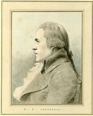
Samuel Pepys Cockerell was an English architect.

Northleach is a market town and former civil parish, now in parish Northleach with Eastington, in the Cotswold district, in Gloucestershire, England. The town is in the valley of the River Leach in the Cotswolds, about 10 miles (16 km) northeast of Cirencester and 11 miles (18 km) east-southeast of Cheltenham. The 2011 Census recorded the parish's population as 1,854, the same as Northleach built-up-area.

Adlestrop is a village and civil parish in the Cotswolds, 3 miles (5 km) east of Stow-on-the-Wold, Gloucestershire, England, on the county boundary with Oxfordshire. The River Evenlode forms the southwest boundary of the parish. The village is on a stream that flows southwest to join the river.

Old Sodbury is a small village and former civil parish in the valley of the River Frome just below and to the west of the Cotswold escarpment and to the east of Chipping Sodbury and Yate, now in the parish of Sodbury, in the South Gloucestershire district, in the ceremonial county of Gloucestershire, England. It is situated in the Hundred of Grumbald's Ash. The village extends from Chipping Sodbury in the West to the Cotswold Edge in the East and is on the Cotswold Way. The Badminton Road (A432) winds eastwards towards Badminton, Gloucestershire through the village, up to the Cross Hands junction with the A46, which runs along the top of the Cotswold escarpment from Bath to Stroud. In 1931 the parish had a population of 837. On 1 April 1946 the parish was abolished to form Sodbury.

Stanley Pontlarge is a village and former civil parish, now in the civil parish of Prescott and the ecclesiastical parish of Winchcombe, in the Tewkesbury district, in the county of Gloucestershire, England. Stanley Pontlarge lies on the steep northern escarpment of the Cotswolds. The Gloucestershire Warwickshire Railway is a prominent feature of the landscape. In 1931 the parish had a population of 43.

Owlpen is a small village and civil parish in the Stroud district of Gloucestershire, England, set in a valley in the Cotswold hills. It is about one mile (1.6 km) east of Uley, and three miles (4.8 km) east of Dursley. The Owlpen valley is set around the settlement like an amphitheatre of wooded hills open to the west. The landscape falls within the Cotswold Area of Outstanding Natural Beauty, so designated in 1966. The population of the parish in mid-2010 was 29 (est.), the smallest in Gloucestershire.

Great Barrington is a village and former civil parish, now in the parish of Barrington, in the Cotswold district of Gloucestershire, England. It lies in the north bank of the River Windrush, 3 miles (4.8 km) west of the town of Burford, Oxfordshire. In 1931 the parish had a population of 330.

Lower Swell is a village and former civil parish, now in the parish of Swell, in the Cotswold district, in the county of Gloucestershire, England. It is located at the River Dikler, one mile from Stow-on-the-Wold. The village has "finest countryside, a tranquil village green and plenty of mellow stone cottages". The village church is dedicated to St. Mary. In 1931 the parish had a population of 360.

Yelford is a village and former civil parish, now in the parish of Hardwick-with-Yelford, in the West Oxfordshire district, in the county of Oxfordshire, England. It is about 3 miles (5 km) south of Witney. In 1931 the parish had a population of 17.

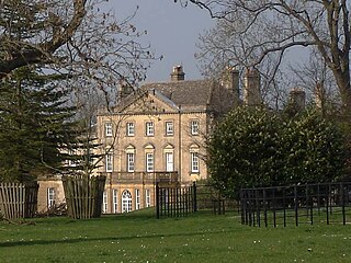
Sezincote House is the centre of a country estate in the civil parish of Sezincote, in the county of Gloucestershire, England. The house was designed by Samuel Pepys Cockerell, built in 1805, and is a notable example of Neo-Mughal architecture, a 19th-century reinterpretation of 16th and 17th-century architecture from the Mughal Empire. At the time of its construction, British India was becoming the "jewel in the crown" of the world's largest empire.
Rowberrow is a small village and former civil parish, now in the parish of Shipham in the Somerset district, in the ceremonial county of Somerset, England. In 1931 the parish had a population of 56. On 1 April 1933 the parish was abolished and merged with Shipham.
Salperton is a village and former civil parish, now in the parish of Hazleton, in the Cotswolds about 8 miles (13 km) east of Cheltenham in Gloucestershire, England. It is also known as Cold Salperton, owing to its exposed position. In 1931 the parish had a population of 92.

Carole Gray Bamford, Baroness Bamford, OBE, is a British businessperson who founded the Daylesford Organic Farmshops chain and the Bamford brand of women's products.

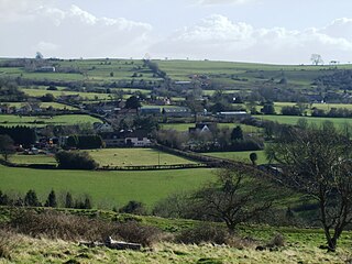
Daylesford House is a Georgian country house near Daylesford, Gloucestershire, England, on the north bank of the River Evenlode near the border with Oxfordshire, 5 miles (8.0 km) east of Stow-on-the-Wold and 5 miles (8.0 km) west of Chipping Norton. The village of Daylesford lies nearby to the west, Adlestrop to the north, Cornwell to the east, and Kingham to the south,
Weston-sub-Edge is a village in Gloucestershire, England.

Evenlode is a village and civil parish in the Cotswold District of eastern Gloucestershire in England.
Didbrook is a small village and former civil parish, now in the parish of Stanway, in the Tewkesbury district, in Gloucestershire, England, 8 miles (13 km) north-east of Cheltenham. The village lies near the foot of the Cotswold escarpment. In 1931 the parish had a population of 160.

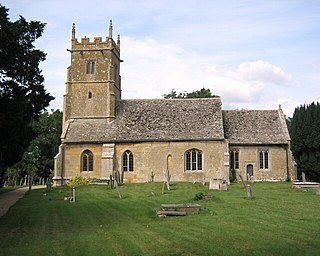
The Anglican Church of St Peter at Daylesford in the Cotswold District of Gloucestershire, England was rebuilt in 1860. It is a grade I listed building.

