
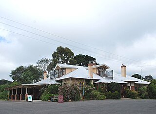
Kingston is a small town in rural Shire of Hepburn in Victoria, Australia. Kingston is located about 15 km from Creswick, just off the Midland Highway and is about 20 km from Daylesford. Kingston's post code is 3364. At the 2016 census, Kingston had a population of 177.

The Shire of Hepburn is a local government area in Victoria, Australia, located in the central part of the state. It covers an area of 1,473 square kilometres (569 sq mi) and, in the 2021 Census the shire had a population of 16,604.

The Daylesford Spa Country Railway is a volunteer-operated 1,600 mm gauge tourist railway located in Victoria, Australia. It operates on a section of the closed and dismantled Daylesford line, and currently runs services between Daylesford and the hamlet of Bullarto.

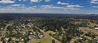
Daylesford is a spa town located in the foothills of the Great Dividing Range, within the Shire of Hepburn, Victoria, Australia, approximately 108 kilometres north-west of Melbourne. First established in 1852 as a gold-mining town, today Daylesford has a population of 2,548 as of the 2016 census.

Allendale is a town in Victoria, Australia, located north-east of Creswick, in the Shire of Hepburn. At the 2016 census, Allendale and the surrounding area had a population of 166.

Ballan is a small town in the state of Victoria, Australia located on the Werribee River, 80 kilometres (50 mi) northwest of Melbourne. At the 2021 census, Ballan had a population of 3,392.

Newlyn is a town in the Shire of Hepburn, in Victoria, Australia. It is situated on the Midland Highway between Creswick and Daylesford. At the 2021 census, Newlyn had a population of 136.
The Central Highlands Football League is an Australian Rules Football League in the Ballarat region. The league coordinates Senior, Reserve, Under 18, Under 15 and Under 12 grades.

Glenlyon is a small village in the Shire of Hepburn local government area, Victoria, Australia around 10 km from Daylesford along the Daylesford - Malmsbury Road, and around 101 km from the Melbourne CBD via Kyneton and Malmsbury.

The Shire of Creswick was a local government area about 120 kilometres (75 mi) west-northwest of Melbourne, the state capital of Victoria, Australia. The shire covered an area of 551.66 square kilometres (213.0 sq mi), and existed from 1859 until 1995.

The Shire of Daylesford and Glenlyon was a local government area about 110 kilometres (68 mi) northwest of Melbourne, the state capital of Victoria, Australia. The shire covered an area of 609.3 square kilometres (235.3 sq mi), and existed from 1966 until 1995.

The Hepburn Wind Project is a wind farm built and owned by Hepburn Wind, a community co-operative, and supported by the Victorian Government. The location of the project is Leonards Hill, 10 kilometres (6.2 mi) south of Daylesford, Victoria, north-west of Melbourne, Victoria. It comprises two individual 2.05 MW wind turbines supplied by REpower System AG which are projected to produce enough energy for 2,300 households, almost as many houses are in the twin-towns of Daylesford and Hepburn Springs.

Franklinford is a small community in the Central Highlands of Victoria, Australia, located in the Shire of Hepburn.
Lyonville is a town located in the Shire of Hepburn, Victoria, Australia. East of Daylesford on the Trentham road, the town takes its name from James Lyon who had arrived in the Glenlyon district in the 1860s. At the 2016 census, Lyonville had a population of 175.

Leonards Hill is a village located in the Shire of Hepburn, Victoria, Australia. At the 2016 census, Leonards Hill had a population of 45.

Mount Franklin is an extinct volcano about 10 km north of Daylesford and 4.6 km south east of Franklinford in Victoria, Australia. A road spirals round the outside slopes covered with pine trees, into a flat 50 acre caldera, now used as a camping ground, and onto the rim which hosts a fire lookout, parking area and picnic ground.
The Wombat Hill Botanic Gardens in Daylesford, Victoria, Australia, are included on the Victorian Heritage Register.

The Daylesford Advocate was a Victorian newspaper first published in 1878 as The Daylesford Advocate and Hepburn Glenlyon and Blanket Flat Chronicle.
The ChillOut Festival is held in Daylesford, Victoria, every year on the Victorian Labour Day long weekend in March. It commenced in 1997 and is now the largest LGBTQI festival in regional Australia, and also the largest festival of any kind in the Shire of Hepburn.
Strangways is a locality within the local government area of Mount Alexander, in Central Victoria, Australia. It covers an area of 20.105 square kilometres between the townships of Guidford to the east, Newstead to the north-west and Clydesdale to the south.
