Related Research Articles
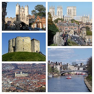
York is a cathedral city with Roman origins, sited at the confluence of the rivers Ouse and Foss in North Yorkshire, England. It is the historic county town of Yorkshire. The city has many historic buildings and other structures, such as a minster, castle, and city walls. It is the largest settlement and the administrative centre of the wider City of York district.

Southwell is a minster and market town in the district of Newark and Sherwood in Nottinghamshire, England. It is home to the grade-I listed Southwell Minster, the cathedral of the Anglican Diocese of Southwell and Nottingham. The population of the town was recorded at 7,558 in the 2021 Census. The town is on the River Greet and is located geographically 9 miles (14 km) west of Newark on Trent, 15 miles (24 km) north-east of Nottingham, 13 miles (21 km) south-east of Mansfield and 22 miles (35 km) south-east of Worksop.
York had around 45 parish churches in 1300. Twenty survive, in whole or in part, a number surpassed in England only by Norwich, and 12 are used for worship. This article consists of a list of medieval churches which still exist in whole or in part, and a list of medieval churches which are known to have existed in the past but have been completely demolished.

Stonegate is a street in the city centre of York, in England, one of the streets most visited by tourists. Most of the buildings along the street are listed, meaning they are of national importance due to their architecture or history.
York Civic Trust is a membership organisation and a registered charity based in York, UK. Its primary function is to "preserve, protect and advise on the historic fabric of York". It is based in Fairfax House.
Goodramgate is a street in the city centre of York, in England.
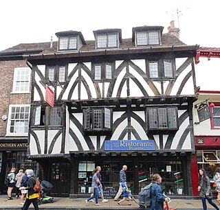
41–45 Goodramgate is a grade I listed building in the city centre of York, in England.

The Archbishop's Palace was the residence of the Archbishop of York during the later Middle Ages. It lay immediately north of York Minster, and its grounds are now known as Dean's Park.

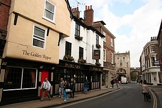
Petergate is a street in the city centre of York, in England. It is divided into High Petergate and Low Petergate. The well-known view of the Minster from Low Petergate is described by the City of York Council as "excellent".

Monkgate is a street in York, North Yorkshire running north-east from the city centre.

Ogleforth is a street in the city centre of York, in England.

Bedern is a street in the city centre of York, in England, which originated as a college for the vicars choral of York Minster.

30 and 32 Goodramgate and 11 and 12 College Street is a Grade II* listed building in the city centre of York, in England.

College Green is an open space in the city centre of York, England.

Minster Yard is a street in the city centre of York, England. It runs along the southern, eastern and northeastern sides of York Minster, for which it is named.

Old Residence is an historic building in the English city of York, North Yorkshire. A Grade II* listed building, located at 6 Minster Yard, at its junction with College Street, the building dates to the early 18th century, but it was raised and reroofed in 1786, as well has receiving a small extension in the late 19th century.

The Minster Close or Minster Precinct is the area surrounding York Minster. It first appeared in records from the late 13th century, when a wall was constructed around it.

Minster Gates is a north–south running street in the city centre of York, England, connecting Minster Yard and High Petergate. All of its buildings are listed, many dating to the 18th century, although the street is significantly older.

Chapter House Street is a street in the city centre of York, England, connecting Ogleforth and Minster Yard.
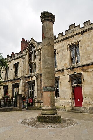
A Roman column stands in Minster Yard in the English city of York. Originally built around the first century, by the soldiers of Legio IX Hispana, it was reused by Legion VI in the 4th century. It is believed to have been part of a group of sixteen freestanding columns, supporting the walls of an earlier church on the site.
References
- 1 2 An Inventory of the Historical Monuments in City of York, Volume 5, Central. London: HMSO. 1981. Retrieved 7 August 2020.
- ↑ "The history of York's Duncombe Place" – York Press , 18 September 2014
- ↑ "Minster Close". York Civic Trust. Retrieved 4 December 2021.
- ↑ "Previous Initiatives: Closure of Deangate". York Civic Trust. Retrieved 4 December 2021.
| | This United Kingdom road or road transport-related article is a stub. You can help Wikipedia by expanding it. |