Dearborn, Missouri

Last updated

Dearborn, Missouri
Platte County Missouri Incorporated and Unincorporated areas Dearborn Highlighted.svg
Location within Platte County and Missouri
Coordinates: 39°31′30″N94°46′26″W / 39.52500°N 94.77389°W / 39.52500; -94.77389 [1]
Country United States
State Missouri
Counties Buchanan, Platte
Incorporated 1882
Area
[2]
  Total0.84 sq mi (2.16 km2)
  Land0.82 sq mi (2.12 km2)
  Water0.02 sq mi (0.05 km2)
Elevation
[1]
879 ft (268 m)
Population
 (2020)
  Total482
  Density589.24/sq mi (227.51/km2)
Time zone UTC-6 (Central (CST))
  Summer (DST) UTC-5 (CDT)
ZIP code
64439
Area code 816
FIPS code 29-18658 [3]
GNIS feature ID2394478 [1]
Website https://www.cityofdearbornmo.org/

Dearborn is a city in Buchanan and Platte counties in the U.S. state of Missouri and is part of the Kansas City metropolitan area. The population was 482 at the 2020 census.

Contents

History

The city was named for Henry Dearborn, Revolutionary War general and Secretary of War, [4] [5] and was incorporated in 1882. [6]

From 1913 to 1933, Dearborn was one of the stops along the Kansas City, Clay County and St. Joseph Railway (KCCC&SJ), an interurban light rail line connecting Kansas City and St. Joseph. Portions of the right-of-way and roadbed are still visible from Dearborn north to St. Joseph. [7]

In November 2012, one of two winning tickets for a then record-breaking $587.5 million Powerball jackpot was purchased at the Trex Mart gas station in Dearborn. [8]

Geography

Dearborn is located in northern Platte County and centered about one-half mile south of the Platte-Buchanan county line. The Dearborn Reservoir is just across the county line to the north. The community is on Routes Z and Y one mile east of U.S. Route 71. Bee Creek flows past the west side of the community. [9]

According to the United States Census Bureau, the city has a total area of 0.91 square miles (2.36 km2), of which 0.89 square miles (2.31 km2) is land and 0.02 square miles (0.05 km2) is water. [10]

Demographics

Historical population
CensusPop.Note
1890 239
1900 567137.2%
1910 499−12.0%
1920 57815.8%
1930 549−5.0%
1940 456−16.9%
1950 391−14.3%
1960 44413.6%
1970 54322.3%
1980 5470.7%
1990 480−12.2%
2000 52910.2%
2010 496−6.2%
2020 482−2.8%
U.S. Decennial Census [11]

The Platte County portion of Dearborn (the majority of the city) is part of the Kansas City, MO KS Metropolitan Statistical Area, while the Buchanan County portion is part of the St. Joseph, MOKS Metropolitan Statistical Area.

2010 census

As of the census [12] of 2010, there were 496 people, 234 households, and 120 families living in the city. The population density was 557.3 inhabitants per square mile (215.2/km2). There were 269 housing units at an average density of 302.2 per square mile (116.7/km2). The racial makeup of the city was 96.4% White, 0.4% African American, 0.2% Native American, 1.2% from other races, and 1.8% from two or more races. Hispanic or Latino of any race were 2.6% of the population.

There were 234 households, of which 26.9% had children under the age of 18 living with them, 41.0% were married couples living together, 8.1% had a female householder with no husband present, 2.1% had a male householder with no wife present, and 48.7% were non-families. 41.9% of all households were made up of individuals, and 20% had someone living alone who was 65 years of age or older. The average household size was 2.12 and the average family size was 2.98.

The median age in the city was 38.7 years. 23.2% of residents were under the age of 18; 8% were between the ages of 18 and 24; 24.5% were from 25 to 44; 25.4% were from 45 to 64; and 19% were 65 years of age or older. The gender makeup of the city was 48.6% male and 51.4% female.

2000 census

As of the census [3] of 2000, there were 529 people, 230 households, and 134 families living in the city. The population density was 615.9 inhabitants per square mile (237.8/km2). There were 258 housing units at an average density of 300.4 per square mile (116.0/km2). The racial makeup of the city was 96.22% White, 0.38% African American, 0.76% Native American, 0.19% Asian, 1.13% from other races, and 1.32% from two or more races. Hispanic or Latino of any race were 1.32% of the population.

There were 230 households, out of which 30.0% had children under the age of 18 living with them, 43.5% were married couples living together, 8.7% had a female householder with no husband present, and 41.7% were non-families. 36.5% of all households were made up of individuals, and 18.7% had someone living alone who was 65 years of age or older. The average household size was 2.30 and the average family size was 3.02.

In the city the population was spread out, with 26.1% under the age of 18, 8.9% from 18 to 24, 25.9% from 25 to 44, 24.0% from 45 to 64, and 15.1% who were 65 years of age or older. The median age was 37 years. For every 100 females, there were 100.4 males. For every 100 females age 18 and over, there were 84.4 males.

The median income for a household in the city was $34,861, and the median income for a family was $47,727. Males had a median income of $34,500 versus $24,808 for females. The per capita income for the city was $17,537. About 4.3% of families and 11.4% of the population were below the poverty line, including 12.5% of those under age 18 and 18.8% of those age 65 or over.

Education

North Platte County R-I School District operates two schools in the community: North Platte Jr. High School and North Platte High School. [13]

Dearborn has a public library, a branch of the Mid-Continent Public Library. [14]

Related Research Articles

<span class="mw-page-title-main">Platte County, Missouri</span> County in Missouri, United States

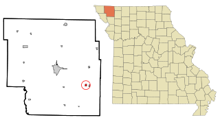
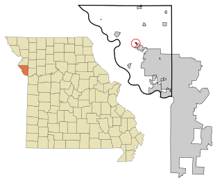
Platte County is a county located in the northwestern portion of the U.S. state of Missouri and is part of the Kansas City metropolitan area. As of the 2020 census, the population was 106,718. Its county seat is Platte City. The county was organized December 31, 1838, from the Platte Purchase, named for the Platte River. The Kansas City International Airport is located in the county, approximately one mile west of Interstate 29 between mile markers 12 and 15. The land for the airport was originally in an unincorporated portion of Platte County before being annexed by Platte City, and eventually Kansas City.

<span class="mw-page-title-main">Glenaire, Missouri</span> City in Missouri, United States

Glenaire is a city in Clay County, Missouri, United States. The population was 539 at the 2020 census. The city is completely surrounded by the city of Liberty. It was originally referred to as "Interurban Heights" or "Belleview" because of the interurban train that ran through the area and stopped at the Belleview depot near the Belleview Dairy. It is part of the Kansas City metropolitan area.

<span class="mw-page-title-main">Smithville, Missouri</span> City in Missouri, United States

Smithville is a city in Clay and Platte counties in the U.S. state of Missouri and is part of the Kansas City metropolitan area, along the Little Platte River. The population was 10,406 at the 2020 United States Census.

<span class="mw-page-title-main">Conception Junction, Missouri</span> City in Missouri, United States

Conception Junction is a city in Nodaway County, Missouri, United States, near the Platte River. The population was 177 at the 2020 census.

<span class="mw-page-title-main">Edgerton, Missouri</span> City in Missouri, United States

Edgerton is a city in northeastern Platte County, Missouri and is part of the Kansas City metropolitan area within the United States. The population was 546 at the 2010 census.

<span class="mw-page-title-main">Farley, Missouri</span> Village in Missouri, United States

Farley is a village in Platte County, Missouri, within the United States, along the Platte River. The population was 269 at the 2010 census. It lies within the Kansas City metropolitan area.

<span class="mw-page-title-main">Ferrelview, Missouri</span> Village in Missouri, United States

Ferrelview is a village in Platte County, Missouri in the United States. It is within the Kansas City metropolitan area. The population was 451 at the 2010 census.

<span class="mw-page-title-main">Lake Waukomis, Missouri</span> City in Missouri, United States

Lake Waukomis is a city in Platte County, Missouri and is part of the Kansas City metropolitan area within the United States. The population was 888 at the 2020 census.

<span class="mw-page-title-main">Northmoor, Missouri</span> City in Missouri, United States

Northmoor is a city in Platte County, Missouri and is part of the Kansas City metropolitan area within the United States. The population was 325 at the 2010 census.

<span class="mw-page-title-main">Parkville, Missouri</span> City in Missouri, United States

Parkville is a city in Platte County, Missouri, United States and is a part of the Kansas City Metropolitan Area. The population was 7,177 at the 2020 census. Parkville is known for its antique shops, art galleries, and historic downtown. The city is home to Park University, English Landing Park, Platte Landing Park, and the National Golf Club of Kansas City. Large neighborhoods in Parkville include: Riss Lake, The National, Thousand Oaks, Creekside, Parkville Heights, River Hills, Riverchase, The Bluffs, Downtown, and Pinecrest.

<span class="mw-page-title-main">Platte City, Missouri</span> City in Missouri, United States

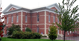
Platte City is a city in and the county seat of Platte County, Missouri within the United States. The population was 4,691 at the 2010 census. The city is part of the Kansas City metropolitan area.

<span class="mw-page-title-main">Ridgely, Missouri</span> Village in Missouri, United States

Ridgely is a village in Platte County, Missouri within the United States. The population was 104 at the 2010 census. It lies within the Kansas City metropolitan area.

<span class="mw-page-title-main">Riverside, Missouri</span> City in Missouri, United States

Riverside is a city in Platte County, Missouri and is part of the Kansas City metropolitan area within the United States. The population was 4,013 at the 2020 census.

<span class="mw-page-title-main">Tracy, Missouri</span> City in Missouri, United States

Tracy is a city in Platte County, Missouri within the United States, located along the Platte River. The population was 269 at the 2020 census. The city is part of the Kansas City metropolitan area.

<span class="mw-page-title-main">Weatherby Lake, Missouri</span> City in Missouri, United States

Weatherby Lake is a city in Platte County, Missouri and is part of the Kansas City metropolitan area within the United States, which borders Kansas City. The population was 1,723 as of the 2010 census.

<span class="mw-page-title-main">Camden Point, Missouri</span> City in Missouri, United States

Camden Point is a city in Platte County, Missouri, United States and is part of the Kansas City metropolitan area. The population was 474 at the 2010 census.

<span class="mw-page-title-main">Houston Lake, Missouri</span> City in Missouri, United States

Houston Lake is a city in Platte County, Missouri, and is part of the Kansas City metropolitan area within the United States. The population was 235 at the 2010 census.

<span class="mw-page-title-main">Iatan, Missouri</span> Village in Missouri, United States

Iatan is a village in Platte County, Missouri within the United States. The population was 69 at the 2010 census. It is within the Kansas City metropolitan area.

<span class="mw-page-title-main">Platte Woods, Missouri</span> City in Missouri, United States

Platte Woods is a city in Platte County, Missouri and is part of the Kansas City metropolitan area within the United States. The population was 394 as of the 2020 census.

<span class="mw-page-title-main">Platte, South Dakota</span> City in South Dakota, United States

Platte is a city in Charles Mix County, South Dakota, United States. The population was 1,311 at the 2022 census. The community is named after the Platte Creek, a tributary of the Missouri River reservoir Lake Francis Case. Platte is located 15 miles east of Lake Francis Case on the Missouri River.

References

  1. 1 2 3 U.S. Geological Survey Geographic Names Information System: Dearborn, Missouri
  2. "ArcGIS REST Services Directory". United States Census Bureau. Retrieved August 28, 2022.
  3. 1 2 "U.S. Census website". United States Census Bureau . Retrieved January 31, 2008.
  4. Eaton, David Wolfe (1917). How Missouri Counties, Towns and Streams Were Named. The State Historical Society of Missouri. pp.  342.
  5. "Profile for Dearborn, Missouri". ePodunk. Archived from the original on June 9, 2011. Retrieved June 18, 2010.
  6. "Dearborn profile". City Data.com. 2012. Retrieved November 29, 2012.
  7. "Kansas City, Clay County & St. Joseph Interurban Railway". Interurban road.com. 2007. Retrieved November 29, 2012.
  8. Heintzelman, Aaron (November 29, 2012). "Missouri's Powerball winner sold at Trex Mart in Dearborn". KSHB-TV. Archived from the original on December 2, 2012. Retrieved November 29, 2012.
  9. Missouri Atlas & Gazetteer, DeLorme, 1998, First edition, p. 26 ISBN   0-89933-224-2
  10. "US Gazetteer files 2010". United States Census Bureau. Archived from the original on July 2, 2012. Retrieved July 8, 2012.
  11. "Census of Population and Housing". Census.gov. Retrieved June 4, 2015.
  12. "U.S. Census website". United States Census Bureau . Retrieved July 8, 2012.
  13. "North Platte County R-I School District". Great Schools. Retrieved March 17, 2018.
  14. "Locations". Mid-Continent Public Library. Retrieved March 17, 2018.