Denholm

Last updated

Denholm
Denhom monument2.jpg
Leyden's monument on the Green, Denholm
Scottish Borders UK location map.svg
Red pog.svg
Denholm
Location within the Scottish Borders
Population710 (mid-2020 est.) [1]
OS grid reference NT568184
Council area
Lieutenancy area
Country Scotland
Sovereign state United Kingdom
Post town HAWICK
Postcode district TD9
Dialling code 01450 870
Police Scotland
Fire Scottish
Ambulance Scottish
UK Parliament
Scottish Parliament
List of places
UK
Scotland
55°27′29″N2°41′05″W / 55.457978°N 2.68467°W / 55.457978; -2.68467 Coordinates: 55°27′29″N2°41′05″W / 55.457978°N 2.68467°W / 55.457978; -2.68467

Denholm is a small village located between Jedburgh and Hawick in the Scottish Borders region of Scotland, UK. The estimated population of Denholm is 600. There is a village green in the centre. It lies in the valley of the River Teviot. Denholm is a Conservation Area listed as 'a planned village as opposed to the traditional unplanned or organic form of village usually found in Roxburghshire.'

Contents

The village of Denholm is situated in Teviotdale, about halfway between the towns of Hawick and Jedburgh. It lies in gentle rolling countryside between Rubers Law and the Minto Hills, volcanic outcrops which thrust up through the underlying Old Red Sandstone.

The original settlement of 'Denum' was sited 'at the valleys' where the broad valley of the River Teviot meets the narrow glen of the Dean Burn. The early hamlet was plundered and burnt during English raids of the 16th century. The village we see today dates from the 17th century when it was laid out around the Green.

The population of the village is 653 (in 2011). [2]

History

The village is built around the Green, which in days gone by was let for grazing to the butchers or smallholders. In the middle of the Green stands Leyden's Monument, which was erected in 1861 in honour of Dr John Leyden (1775–1811), poet, antiquarian and orientalist, who was born in Denholm. The monument was designed by the architect Hector H. Orrock, and sculpted by Alexander Handyside Ritchie. [3] The Green has always been at the heart of village life. Weekly and half-weekly fairs used to be held here. Part of the base of an old mercat cross can still be seen inside the railings surrounding the monument. The cross itself was removed and the base hollowed out sometime in the 19th century to make a water trough for cattle. Westgate Hall built in 1663 stands at the western approaches to the village. [4]

In Main Street, stands The Text House, a category B listed building, erected about 1910 by John Haddon (1845–1924), a medical doctor and author of published works on public sanitation and dietetics. The 3-storey house is in the arts and craft style. One of the texts on the front elevation is a reminder to take care with time before it passes, "TAK TENT IN TIME ~ ERE TIME BE TINT", the other text reminds the occupier that there were and will be others living in the house, "ALL WAS OTHERS ~ ALL WILL BE OTHERS". [5]

Council pre-fabs were put up in the Ashloaning at the end of the war followed by the "Crudens semis" and the "Orlits". During the 1950s, six more semi-detached houses were built in The Loaning and ten in Murray Place. All through the 1950s the public water supply was inadequate for the post-war village, but in 1963 a proper supply was finally piped in from Alemoor Loch above Roberton. The way was now open for more housing development. Like most villages, Denholm is expanding, and many new houses have been built in the past few years. Denholm Mill and Denholm Hall Farm have both been developed for housing, but the centre of the village around the Green is a conservation area.

Denholm was the only village in the civil parish of Cavers and is situated in the north-east corner of the parish. [6]

See also

Famous sons of Denholm

Related Research Articles

<span class="mw-page-title-main">Hawick</span> A town in the Borders of Scotland

Hawick is a town in the Scottish Borders council area and historic county of Roxburghshire in the east Southern Uplands of Scotland. It is 10 miles (16.1 km) south-west of Jedburgh and 8.9 miles (14.3 km) south-south-east of Selkirk. It is one of the farthest towns from the sea in Scotland, in the heart of Teviotdale, and is the biggest town in the former county of Roxburghshire. The town is at the confluence of the Slitrig Water with the River Teviot.

<span class="mw-page-title-main">Scottish Borders</span> Council area of Scotland

The Scottish Borders is one of 32 council areas of Scotland. It borders the City of Edinburgh, Dumfries and Galloway, East Lothian, Midlothian, South Lanarkshire, West Lothian and, to the south-west, south and east, the English counties of Cumbria and Northumberland. The administrative centre of the area is Newtown St Boswells.

<span class="mw-page-title-main">John Leyden</span> Scottish orientalist and translator

John Caspar Leyden, M.D., was a Scottish indologist.

<span class="mw-page-title-main">Jedburgh</span> Town in Scotland

Jedburgh is a town and former royal burgh in the Scottish Borders and the traditional county town of the historic county of Roxburghshire, the name of which was randomly chosen for Operation Jedburgh in support of the D-Day invasion.

<span class="mw-page-title-main">Roxburghshire</span> Historic county in Scotland

Roxburghshire or the County of Roxburgh is a historic county and registration county in the Southern Uplands of Scotland. It borders Dumfriesshire to the west, Selkirkshire and Midlothian to the north-west, and Berwickshire to the north. To the south-west it borders Cumberland and to the south-east Northumberland, both in England.

<span class="mw-page-title-main">Selkirkshire</span> Historic county = in Scotland

Selkirkshire or the County of Selkirk is a historic county and registration county of Scotland. It borders Peeblesshire to the west, Midlothian to the north, Roxburghshire to the east, and Dumfriesshire to the south. It derives its name from its county town, the royal burgh of Selkirk. The county was historically also known as Ettrick Forest.

<span class="mw-page-title-main">Newtown St Boswells</span> Human settlement in Scotland

Newtown St Boswells is a village in the historic county of Roxburghshire which houses the administrative centre of the Scottish Borders council area. The village lies south of the Eildon Hills on the Sprouston and Newtown burns, between the larger settlements of St Boswells 1 mile (1.6 km) to the south-east and Melrose 2.5 miles (4.0 km) to the north-west.

<span class="mw-page-title-main">Nisbet, Scottish Borders</span>

Nisbet is a small hamlet on the B6400, in Roxburghshire, along the River Teviot, in the Scottish Borders area of Scotland. It is located 5.5 kilometres (3.4 mi) north of Jedburgh and 5 kilometres (3.1 mi) south of Roxburgh.

<span class="mw-page-title-main">Ancrum</span> Human settlement in Scotland

Ancrum is a village in the Borders area of Scotland, 5 km north west of Jedburgh.

Minto is a village and parish in the Scottish Borders area of Scotland in Roxburghshire county. It is located 6 miles north-east of Hawick, north of the River Teviot.

<span class="mw-page-title-main">Bedrule</span> Hamlet and civil parish in the Scottish Borders area of Scotland

Bedrule is a hamlet and civil parish in the historic county of Roxburghshire in the Scottish Borders area of Scotland. The hamlet lies on the east side of the Rule Water, which gave the village its name, about 4 miles west of Jedburgh. It lies south of the A698 between Hawick and Jedburgh. Other local place-names based on the river include Hallrule, Abbotrule, Ruletownhead and Spittal-on-Rule. Larger settlements include Bonchester Bridge and Denholm, as well as Hawick and Jedburgh.

<span class="mw-page-title-main">Bonjedward</span>

Bonjedward is a hamlet in the Scottish Borders area of Scotland, two miles north of Jedburgh where the Jed Water joins the River Teviot.

<span class="mw-page-title-main">Rubers Law</span>

Rubers Law is a prominent, conical hill in the Scottish Borders area of south-east Scotland. It stands on the south bank of the River Teviot, between the towns of Hawick and Jedburgh, and south of the village of Denholm. The hill is on the border between the historic parishes of Cavers and Hobkirk, and until 1975 it stood within the historic county of Roxburghshire.

<span class="mw-page-title-main">Eckford, Scottish Borders</span>

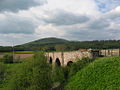
Eckford is a small village located between the larger towns of Kelso and Jedburgh in the Scottish Borders. The village is in close proximity to both the River Teviot and its tributary the Kale Water, and the A698 and the B6401 which run approximately parallel to the respective rivers.

<span class="mw-page-title-main">Darnick</span> Village in the Scottish Borders

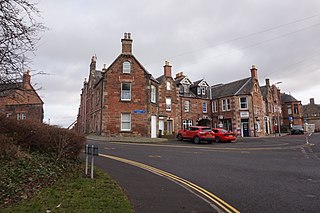
Darnick is a village near Melrose in the Scottish Borders area of Scotland, in the former Roxburghshire. The name was first recorded in 1124, and has changed from Dernewic, Dernwick and Darnwick to the present Darnick. Darnick Tower was built in c. 1425, and another tower house, Fisher's Tower, is still recognisable by its remains.

<span class="mw-page-title-main">Cavers, Scottish Borders</span> Human settlement in Scotland

Cavers is a parish in the Scottish Borders area of Scotland, in the former county of Roxburghshire, south and east of Hawick. The largest village in the parish is Denholm.

<span class="mw-page-title-main">Castleton, Scottish Borders</span> Village in Scottish Borders, Scotland, UK

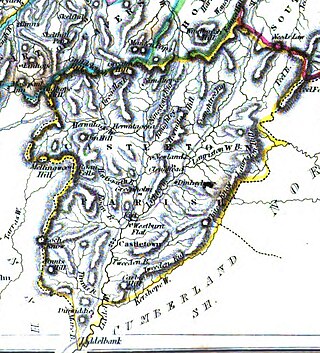
Castleton is a civil parish in the Scottish Borders area of Scotland, in the former Roxburghshire, in the extreme south of the Borders area. It is bounded by Northumberland (England), Dumfries and Galloway, and the parishes of Hobkirk, Southdean and Teviothead. The village of Castleton was commenced in 1793. It was built as a result of the land clearances in the 1790s when people were forced to move from Old Castleton village. While the parish retained the name Castleton, the village later became identified as New Castleton or Newcastleton. The parish is also known by its older name Liddesdale

<span class="mw-page-title-main">Crailing</span>

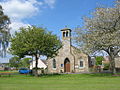
Crailing is a village on the A698, in Teviotdale, 4m east of Jedburgh in the Scottish Borders area of Scotland, in the historic county of Roxburghshire.

<span class="mw-page-title-main">Westgate Hall, Denholm</span>

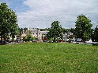
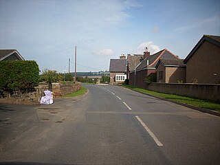
Westgate Hall is located in Westgate in the village of Denholm, Roxburghshire, in the Scottish Borders. It stands at the western and south-western approaches to the village. Dating from the 17th century, it is an example of a building of that period that was once common in Scotland and is now a category A listed building.

References

  1. "Mid-2020 Population Estimates for Settlements and Localities in Scotland". National Records of Scotland. 31 March 2022. Retrieved 31 March 2022.
  2. Census of Scotland 2011, Table KS101SC – Usually Resident Population, publ. by National Records of Scotland. Web site http://www.scotlandscensus.gov.uk/ retrieved Oct 2016. See “Standard Outputs”, Table KS101SC, Area type: Settlement
  3. Historic Environment Scotland. "Denholm, The Green, Leyden Monument (Category C Listed Building) (LB2053)" . Retrieved 15 March 2019.
  4. An inventory of the ancient and historical monuments of Roxburghshire, publ. by Royal Commission on the Ancient and Historical Monuments of Scotland, Edinburgh, 1956; p.100, no.132
  5. Dr John Haddon & The Text House
  6. New Statistical Account of Scotland, Vol III Roxburgh, Peebles, Selkirk, publ.William Blackwood, 1845 pp. 425-439