Pike County is a county in the Commonwealth of Pennsylvania. It is part of Northeastern Pennsylvania. As of the 2020 census, the population was 58,535. Its county seat is Milford.

Delaware Township is a township in Pike County, Pennsylvania, United States. The population was 7,453 at the 2020 census. The Birchwood Lakes housing community is located in Delaware Township.

U.S. Route 206 is a 130.23-mile-long (209.58 km) north–south United States highway in New Jersey and Pennsylvania, United States. Only about a half a mile of its length is in Pennsylvania; the Milford–Montague Toll Bridge carries it over the Delaware River into New Jersey, where it connects to the remainder of the route. Its southern terminus is at an intersection with US 30 and Route 54 in Hammonton. The highway's northern terminus is at an intersection with US 209 near Milford, Pennsylvania; some sources and signs show an overlap with US 209 to end at its parent route US 6. For much of its length, US 206 is a rural two-lane undivided road that passes through the Pine Barrens, agricultural areas, and the Appalachian Mountains of northwestern New Jersey, with some urban and suburban areas. The route connects several cities and towns, including Bordentown, Trenton, Princeton, Somerville, Roxbury, Netcong, and Newton. The road is known as the Disabled American Veterans Highway for much of its length.

The Commodore Barry Bridge is a cantilever bridge that spans the Delaware River from Chester, Pennsylvania to Bridgeport, New Jersey, in Logan Township. It is named after John Barry, an American Revolutionary War hero and Philadelphia resident.

The Delaware River Joint Toll Bridge Commission (DRJTBC) is a bistate, public agency that maintains and operates river crossings connecting the U.S. states of Pennsylvania and New Jersey. The agency's jurisdiction stretches roughly 140 miles (230 km) along the Delaware River from Philadelphia and Bucks County in southeast Pennsylvania and then north through the Lehigh Valley and to Pennsylvania-New York state border.

The Milford–Montague Toll Bridge is a truss bridge that crosses the Delaware River, connecting Montague Township, New Jersey to Dingman Township, Pennsylvania on U.S. Route 206, near the town of Milford. The two-lane bridge, which opened on December 30, 1953, has a total length of 1,150 feet, and is operated by the Delaware River Joint Toll Bridge Commission.
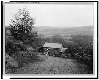
Dingmans Ferry is an unincorporated community in Delaware Township, Pike County, Pennsylvania, United States. As of 2014, it had a population of just over 1,000 people. It was originally sited on the Delaware River, in an area now included in the Delaware Water Gap National Recreation Area. When the Corps of Engineers acquired the land by eminent domain in the mid-twentieth century for the creation of the proposed Tocks Island Dam project, it relocated the community further up the hill.

The Delaware Water Gap Toll Bridge is a toll bridge that carries Interstate 80 across the Delaware River at the Delaware Water Gap, connecting Hardwick Township, Warren County, New Jersey, and Delaware Water Gap, Monroe County, Pennsylvania, in the United States. The bridge was built by the Delaware River Joint Toll Bridge Commission. The 2,465-foot-long (751 m) bridge is a multiple span dual roadway with a steel plate structure. The roadways are 28 feet (8.5 m) wide each and separated from each other by a concrete Jersey barrier.

The Delaware River–Turnpike Toll Bridge is a four-lane, steel through arch bridge crossing the Delaware River between Burlington Township, Burlington County, New Jersey and Bristol Township, Bucks County, Pennsylvania. As a part of Interstate 95 (I-95), it is a major highway link between Philadelphia and New York City. The bridge also connects the Pennsylvania Turnpike's east-west mainline with the main trunk of the New Jersey Turnpike, via the Pearl Harbor Memorial Turnpike Extension. Tolls are collected only in the west/southbound direction via electronic toll collection.

County Route 560 is a county highway in the U.S. state of New Jersey. The highway extends 5.05 miles (8.13 km) from U.S. Route 206 and County Route 521 in Sandyston Township. CR 560 ends at the Pennsylvania state line, where it becomes Pike County Quadrant Route 2019, which connects to Pennsylvania Route 739. CR 560's entire length is in Sandyston. However, CR 560 does pass through the hamlet of Layton.

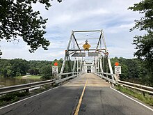
Pennsylvania Route 739 is a Pennsylvania highway contained entirely within Pike County, Pennsylvania. It was signed in 1967, and runs for 19 miles (31 km). Its northern terminus is at U.S. Route 6 in Blooming Grove, running south to US 209 in Delaware Township. PA 739's southern end is at the Dingman's Ferry Bridge at the Delaware River near Layton, New Jersey. It continues as County Route 560 in New Jersey.

The Portland–Columbia Toll Bridge is a toll bridge over the Delaware River between Pennsylvania Route 611 at Portland, Pennsylvania, and U.S. Route 46 in the Columbia section of Knowlton Township, New Jersey, United States. It is owned and operated by the Delaware River Joint Toll Bridge Commission.
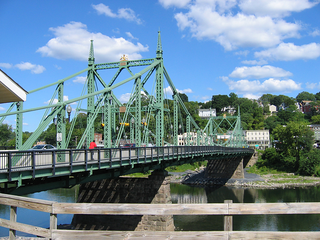
The Northampton Street Bridge is a bridge that crosses the Delaware River, connecting Easton, Pennsylvania, and Phillipsburg, New Jersey, United States. It is maintained by the Delaware River Joint Toll Bridge Commission despite not being a toll bridge. It is known locally as the "Free Bridge" thus distinguishing it from the Easton–Phillipsburg Toll Bridge just upstream to the north. The crossing was first a ferry crossing run by David Martin, beginning in 1739.

State Quadrant Route 2001 in Pike County, Pennsylvania is a 22-mile (35 km) road in Dingman, Lehman, Delaware and Milford Townships. Formerly Pennsylvania Route 962 in part, the road stretches from U.S. Route 209 in Lehman Township to West Harford Street in downtown Milford. There are very few notable roads that intersect with SR 2001, the main three being Pennsylvania Route 739, Log Tavern Road and Raymondskill Road.
Conashaugh, Pennsylvania is a ghost town in Delaware Township, Pike County, Pennsylvania between Dingmans Ferry, Pennsylvania, Milford, Pennsylvania and Birchwood Lakes, Pennsylvania. It is along the Delaware River bordering New Jersey and is now a part of the Delaware Water Gap National Recreation Area. It was originally occupied by American Civil War deserters, and is now considered a ghost town due to the decline of its original population.
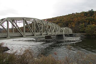
The Pond Eddy Bridge is a petit truss bridge spanning the Delaware River between the hamlet of Pond Eddy in Lumberland, New York and the settlement informally called Pond Eddy in Shohola Township, Pennsylvania. It is accessible from NY 97 in Lumberland on the New York side and two dead-end local roads, Flagstone Road and Rosa Road on the Pennsylvania side. The bridge was built in 1903 by the Oswego Bridge Company to replace an old suspension bridge that had washed away in a flood earlier in the year. It connected the bluestone quarries in Pennsylvania to New York.

The Barryville–Shohola Bridge is the fifth generation of bridges constructed over the Delaware River at the communities of Shohola Township, Pennsylvania and Barryville, New York. The bridge serves both communities, with two major state legislative highways, Pennsylvania Traffic Route 434 and New York State Touring Route 55. The bridge itself is 812 feet (247 m) long and is 23 feet (7.0 m) wide, using four total spans across the river. It is maintained by the NY–PA Joint Interstate Bridge Commission, which is jointly owned by the states of New York and Pennsylvania.

The Callahan House, also known as the Jacob Helm House, is a historic home located in the Delaware Water Gap National Recreation Area south of Milford, in Dingman Township, Pike County, Pennsylvania. It was built in two sections, with the older dated to about 1800 and the later to about 1820. It is a long, 1+1⁄2-story, clapboard-clad frame dwelling with a steep gable roof. It features exposed chimney backs at the first floor exterior in the Dutch style, and a porch along the newer wing.

Dingman's Ferry Dutch Reformed Church is a historic Dutch Reformed church located on U.S. Route 209 in the Delaware Water Gap National Recreation Area at Dingman's Ferry, Delaware Township, Pike County, Pennsylvania. It was designed in 1837, and built in 1850 in the Greek Revival style. It is a two-story, clapboard clad frame building with a gable roof. It features a large gabled portico supported by four heavy Doric order columns.

U.S. Route 209 (US 209) is a 211.74-mile (340.76 km) long U.S. Highway in the states of Pennsylvania and New York. Although the route is a spur of US 9, US 209 never intersects US 9, coming within five miles of the route and making the short connection via New York State Route 199 (NY 199). The southern terminus of the route is at Pennsylvania Route 147 (PA 147) in Millersburg, Pennsylvania. The northern terminus is at US 9W north of Kingston in Ulster, New York, where the road continues east as NY 199.