Related Research Articles

Dom Henrique of Portugal, Duke of Viseu, better known as Prince Henry the Navigator, was a central figure in the early days of the Portuguese Empire and in the 15th-century European maritime discoveries and maritime expansion. Through his administrative direction, he is regarded as the main initiator of what would be known as the Age of Discovery. Henry was the fourth child of King Dom John I of Portugal, who founded the House of Aviz.
The history of the Kingdom of Portugal from the Illustrious Generation of the early 15th century to the fall of the House of Aviz in the late 16th century has been named the "Portuguese golden age" and the "Portuguese Renaissance". During this period, Portugal was the first European power to begin building a colonial empire as Portuguese sailors and explorers discovered an eastern route to India as well as several Atlantic archipelagos and colonized the African coast and Brazil. They also explored the Indian Ocean and established trading routes throughout most of southern Asia, sending the first direct European maritime trade and diplomatic missions to Ming China and to Japan, at the same time installing trading posts and the most important colony: Portuguese Macau. The Portuguese Renaissance produced a plethora of poets, historians, critics, theologians, and moralists. The Cancioneiro Geral by Garcia de Resende is taken to mark the transition from Old Portuguese to the modern Portuguese language.
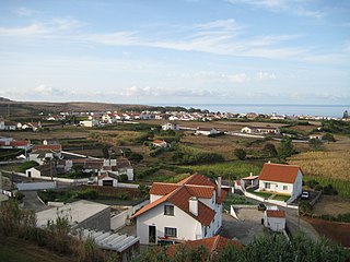
Vila do Porto is the single municipality, the name of the main town and one of the civil parishes on the island of Santa Maria, in the Portuguese archipelago of Azores. Its nearest neighbor, administratively, is the municipality of Povoação on the southern coast of São Miguel, and it is physically southwest of the islets of the Formigas. The population in 2021 was 5,408, in an area of 96.89 km2 (37.41 sq mi).
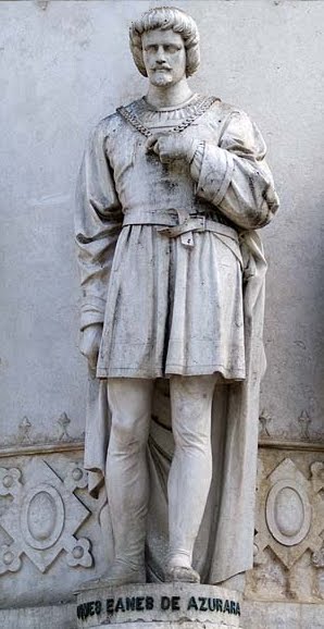
Gomes Eanes de Zurara, sometimes spelled Eannes or Azurara, was a Portuguese chronicler of the European Age of Discovery, the most notable after Fernão Lopes.

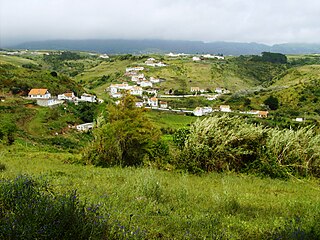
Santa Maria is an island in the eastern group of the Azores archipelago and the southernmost island in the Azores. The island is known for its white sand beaches, distinctive chimneys, and dry warm weather.
Nuno Tristão was a 15th-century Portuguese explorer and slave trader, active in the early 1440s, traditionally thought to be the first European to reach the region of Guinea.

Gonçalo Velho Cabral was a Portuguese monk and Commander in the Order of Christ, explorer and hereditary landowner responsible for administering Crown lands on the same islands, during the Portuguese Age of Discovery.
Vila do Porto is a civil parish in the municipality of Vila do Porto, located on the island of Santa Maria, in the Portuguese autonomous region of Azores. It is the southernmost and easternmost parish in the archipelago of Azores. The population in 2011 was 3,119, in an area of 25.55 km².
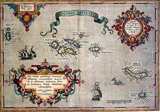
The following article describes the history of the Azores, an archipelago composed of nine volcanic islands in the Macaronesia region of the North Atlantic Ocean, about 1,400 km (870 mi) west of Lisbon, about 1,500 km (930 mi) northwest of Morocco, and about 1,930 km (1,200 mi) southeast of Newfoundland, Canada.
Álvaro Fernandes, was a 15th-century Portuguese explorer from Madeira, in the service of Henry the Navigator. He captained two important expeditions, which expanded the limit of the Portuguese discovery of the West African coast, probably as far as the northern borderlands of modern Guinea-Bissau. Álvaro Fernandes's farthest point would not be surpassed for ten years, until the voyage of Alvise Cadamosto in 1456.

Portuguese maritime exploration resulted in the numerous territories and maritime routes recorded by the Portuguese as a result of their intensive maritime journeys during the 15th and 16th centuries. Portuguese sailors were at the vanguard of European exploration, chronicling and mapping the coasts of Africa and Asia, then known as the East Indies, and Canada and Brazil, in what came to be known as the Age of Discovery.
João de Trasto is the name sometimes given to an obscure Portuguese mariner, who is alleged to have captained the first exploratory expedition dispatched by Prince Henry the Navigator in 1415.
João Soares de Albergaria, also referred to as João Soares, was the second Portuguese Dontary-Captain of the islands of Santa Maria and São Miguel, succeeding his maternal uncle Gonçalo Velho Cabral in the title. After selling his rights to the Captaincy of São Miguel to Rui Gonçalves da Câmara, he continued as Donatary-Captain of Santa Maria.
Gabriel de Vallseca, also referred to as Gabriel de Valseca and Gabriel de Valsequa was a cartographer of Jewish descent connected to the Majorcan cartographic school. His most notable map is the portolan of 1439, containing the first depiction of the recently-discovered Azores islands.
Pedro Vaz Marinheiro was a Portuguese nobleman, navigator, resident and colonizer of the Azores Islands.
Diogo de Melo Coutinho was a Portuguese navigator, co-discoverer of the Azores Islands.
Pedro Annes d'Alpoim was a Portuguese nobleman, conquistador and one of the first settlers of Azores.

Nuno Velho Cabral or Travassos, was a Portuguese nobleman, who served to the Kingdom of Portugal as conquistador and explorer. He accompanied his uncle Gonçalo Velho Cabral, in the voyage of discovery to Santa Maria and São Miguel Island, being one of the first settlers of Azores.

The School of Sagres, also called Court of Sagres is supposed to have been a group of figures associated with fifteenth century Portuguese navigation, gathered by prince Henry of Portugal in Sagres near Cape St. Vincent, the southwestern end of the Iberian Peninsula, in the Algarve.
The Valentim Fernandes manuscript, also known as Relation of Diogo Gomes and Descripcam is a manuscript that discusses the beginning of Portuguese sea navigation. Written in Latin, it is divided into three parts:
References
- 1 2 Gago Coutinho, A Nautica dos Descobrimentos, 1969 edition, Vol. 1, p.208
- ↑ Mees, p.70
- ↑ e.g. by Visconde de Santarem (1841, p.390) Chronica do Descobrimento e Conquista da Guiné.... pelo Chronista Gomes Eannes de Azurara
- ↑ e.g. Beazley, "Introduction", p.lxxxvi, in C.R. Beazley and E. Prestage, editors (1896-99) The Chronicle of the Discovery and Conquest of Guinea, London: Hakluyt, v.1
- ↑ Proposed by Marquis d'Avezac Notice des découvertes faites au môyen-age dans l'Océan Atlantique (1845: p.31) and agreed by Jules Mees Histoire de la découverte des îles Açores (1901: p.71)
- ↑ José Gomez Imaz, 1892 (as quoted in Mees, p.71)
- ↑ 1432 is preferred by the Visconde de Santarem (as it fits with Gonçalo Velho), although d'Avezac, Mees and others read '1427'.
- ↑ Fernandez-Armesto, Felipe (2006). Pathfinders: A Global History of Exploration. New York: W.W. Norton & Company.
- ↑ Diffie, Bailey (1977). Foundations of the Portuguese Empire, 1415–1580. University of Minnesota Press. pp. 465–474. ISBN 0-8166-0782-6.
- ↑ Peres, Damião (1943) História dos Descobrimentos Portugueses.
- ↑ Copies can be found online, e.g. A.N.C. Archived 2011-05-23 at the Wayback Machine (retrieved 25/4/2011)
