
The Government of Ethiopia is structured in a framework of a federal parliamentary republic, whereby the Prime Minister is the head of government. Executive power is exercised by the government. The prime minister is chosen by the parliament. Federal legislative power is vested in both the government and the two chambers of parliament. The Judiciary is more or less independent of the executive and the legislature. They are governed under the 1995 Constitution of Ethiopia. There is a bicameral parliament made of the 108-seat house of federation and the 547-seat House of Peoples Representatives. The house of federation has members chosen by the state assemblies to serve five year terms. The house of people's representatives are elected by direct election, who in turn elect the president for a six-year term.
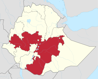
The Oromia Region is a regional state in Ethiopia, the homeland of the Oromo people. It is bordered by the Somali Region to the east; the Amhara Region, the Afar Region and the Benishangul-Gumuz Region to the north; South Sudan, Gambela Region, and Southern Nations, Nationalities, and Peoples' Region to the west; and Kenya to the south. The 2011 census reported the population of Oromia as 35,000,000; this makes it the largest regional state in population. It is also the largest regional state covering 286,612 square kilometers. Oromia is the world's forty-second most populous subnational entity, and the most populous subnational entity in all of Africa.
Adama , officially known as Adaamaa and formerly Nazareth, is a city in central Oromia Region, Ethiopia. Adama forms a Special Zone of Oromia and is surrounded by East Shewa Zone. It is located at 8.54°N 39.27°E at an elevation of 1712 meters, 99 km southeast of Addis Ababa. The city sits between the base of an escarpment to the west, and the Great Rift Valley to the east.

Awash National Park is a national park in Ethiopia. Spanning across the southern tip of the Afar Region and the northeastern corner of the Misraq Shewa Zone of Oromia, this park is 225 kilometers east of Addis Ababa, with its southern boundary along the Awash River, and covers 756 square kilometers of acacia woodland and grassland. The Addis Ababa - Dire Dawa highway passes through this park, separating the Illala Saha Plains to the south from the Kudu Valley to the north. In the south of the park the Awash River gorge has amazing waterfalls. In the upper Kudu Valley at Filwoha are hot springs amid groves of palm trees.

Asella, also Asallaa is a town Located in the Arsi Zone of the Oromia Region about 159 kilometers from Addis Ababa, this city has a latitude and longitude of 7°57′N39°7′E, with an elevation of 2,430 meters. Asalla hosts an airport. Asalla was the capital of Arsi Province until that province was demoted to a Zone of Oromia with the adoption of the 1995 Constitution. It retains some administrative functions as the seat of the present Arsi Zone.
Barentu people, also called Barentoo or Baraytuma, are one of the two main groups of the Oromo people in the Oromia Region of Ethiopia. They historically expanded towards east, southeast and northeast Ethiopia, while the other moiety named Borana Oromo people expanded west, northwest and southwards.
Ethiopia is administratively divided into regional states and chartered cities, zones, woreda (districts) and kebele (wards).
Arboye is a town in eastern Ethiopia and the administrative centre of the Jeju woreda. Located in the Arsi Zone of the Oromia Region, 168 kilometers southeast of Addis Ababa on the road between Adama and Dire Dawa, this town has a latitude and longitude of 8°36′N40°13′E.

The Oromo Liberation Front is a political party established in 1973 by Oromo people in Ethiopia who believe that the Oromo people constitute a separate nation. The movement is the culmination of over 70 years of uncoordinated resistance by Oromos against Ethiopia's central government. The OLF has offices in Addis Ababa (Ethiopia), Washington, D.C. and Berlin from where it operates Amharic and Oromo-language radio stations.
Jarso is one of the woredas in the Oromia Region of Ethiopia. Part of the East Hararghe Zone, Jarso is bordered on the south by the Harari Region, on the west by Kombolcha, on the north by the city of Dire Dawa, on the east by the Somali Region, and on the southeast by Gursum. The administrative center of this woreda is Ejersa Goro.
Kersa is one of the woredas in the East Hararghe Zone of the Oromia Region of Ethiopia. It is named after a river that flows through it, the Kersa. The woreda is bordered on the south by Bedeno, on the west by Meta, on the north by Dire Dawa, on the northeast by Haro Maya, and on the southeast by Kurfa Chele. The administrative center of the woreda is Kersa; other towns include Lange.
Meta is one of the woredas in the Oromia Region of Ethiopia. Part of the Misraq (East) Hararghe Zone, Meta is bordered on the southwest by Deder, on the northwest by Goro Gutu, on the north by the Somali Region, on the northeast by Kersa, and on the southeast by Bedeno. Towns in Meta include Chelenqo and Kulubi.
Arero is one of the woredas in the Oromia Region of Ethiopia. Part of the Borena Zone, Arero is bordered on the southwest by Dire, on the west by Yabelo, on the north by Hagere Mariam, on the northeast by the Guji Zone, on the east by the Somali Region, and on the south by Moyale; the Dawa River, the only river in this woreda, separates Arero from Odo Shakiso and Liben. Towns in Arero include Meta Gefersa.
Moyale is one of the woredas in the Oromia Region of Ethiopia. It is named after the administrative center of the woreda, Moyale. Located in the southeast corner of the Borena Zone, Moyale is bordered on the south by Kenya, on the west by Dire, on the northwest by Arero, on the north by the Dawa River which separates it from Liben, and on the east by Dawa Zone Somali Region.
Dire is one of the woredas in the Oromia Region of Ethiopia. Miyu was separated from Dire woreda. Located in the southern part of the Borena Zone, Dire is bordered on the south by Kenya, on the west by Teltele, on the north by Yabelo, on the northeast by Arero, and on the east by Moyale. Towns in Dire include Mega and Dubuluk.
Ethiopia is currently divided into nine Regions and two chartered cities. Each region or chartered city has their own flag and emblem.
Miyu is one of the woredas in the Oromia Region of Ethiopia. It was separated from Dire woreda. It is part of the Borena Zone. The administrative center of Miyu is Hidi Lola.
The Gurgura, Gorgorah or Gurgure people are a Somali clan that is part of the large Dir clan. They inhabit Dire Dawa, the Erer district in the Sitti Zone, Harar region, large portions of the Oromia Region of Ethiopia and the Afar Region of that country.