Manchester is the most populous city in the U.S. state of New Hampshire and in northern New England, a region comprising the states of Maine, New Hampshire, and Vermont. At the 2020 census, it had a population of 115,644.

The Valley Cemetery is a public cemetery located in Manchester, New Hampshire, United States. It is bounded on the east by Pine Street, on the north by Auburn Street, on the west by Willow Street, and on the south by Valley Street, from which it derives its name. It was listed on the U.S. National Register of Historic Places in 2004, and the New Hampshire State Register of Historic Places in 2003.

The Amoskeag Manufacturing Company was a textile manufacturer which founded Manchester, New Hampshire, United States. From modest beginnings it grew throughout the 19th century into the largest cotton textile plant in the world. At its peak, Amoskeag had 17,000 employees and around 30 buildings.

The Blackstone Manufacturing Company Historic District encompasses the "New City" or "High Rocks" area of Blackstone, Massachusetts, an industrial village associated with the Blackstone Manufacturing Company, which began operations in 1809. It includes an area roughly surrounding Butler, Canal, Church, County, Ives, Main, Mendon, Old Mendon, and School Streets. The district includes a wide variety of worker housing, as well as a granite storehouse, the only surviving company structure. The district was added to the National Register of Historic Places in 1995.

The Ware Millyard Historic District encompasses a 19th-century mill complex and industrial mill village in the town of Ware, Massachusetts. It is roughly bounded by South Street, the Ware River, Upper Dam Complex, Park Street, Otis Avenue and Church Street. The area includes surviving mill buildings, the oldest of which date to the 1840s, and a collection of tenement-style housing built for the millworkers, built between 1845 and the 1880s.

Otis Company Mill No. 1 is a historic mill on E. Main Street in Ware, Massachusetts, United States. Built in 1845, it is one of the best-preserved stone mills in western Massachusetts, and a rare surviving example of a large mill from the pre-turbine phase of industrialization. The building was listed on the National Register of Historic Places in 1982. It was further listed as a contributing property to the Ware Millyard Historic District in 1986.
The Hadley Falls Company Housing District is a residential historic district encompassing a compact tract of factory worker housing in Holyoke, Massachusetts. Built in 1847-48, it is one of the earliest and largest surviving examples of company-built worker housing in the state. It includes five rowhouses facing Center, Lyman, Grover, and Canal Streets. The district was listed on the National Register of Historic Places in 1972.

The Dwight Manufacturing Company Housing District is a residential historic district in Chicopee, Massachusetts. Roughly bounded by Front, Depot, Dwight, Exchange, and Chestnut Streets, it encompasses a variety of housing built for mill workers at Chicopee's mills during the 19th century. This cluster is one of few remnants of such housing, which was built on a larger scale now diminished by urban renewal. The district was listed on the National Register of Historic Places in 1977.

The Lawton Place Historic District is a historic district on Lawton Place between Amory Road and Jackson Street in Waltham, Massachusetts. The district preserves some of the nation's oldest textile mill worker housing. The duplex houses located on the south side of Lawton Place were built c. 1815-17 by the Boston Manufacturing Company (BMC), the first mill to process textiles entirely under one roof. They were originally located at what is now the Waltham Common, and were moved to Lawton Place in 1889. On the north side stands a rowhouse that was built in 1889; it is the last instance of a type of row housing that was once commonly built for mill workers. The district was listed on the National Register of Historic Places in 1989.

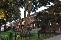
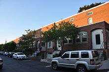
District A is a historic worker housing district located in Manchester, New Hampshire, near the former Amoskeag Manufacturing Company millyard. It is bounded by Pleasant, State, Granite, and Bedford streets, and includes seven surviving tenement blocks built by Amoskeag between 1843 and 1852. The district was added to the National Register of Historic Places on November 12, 1982.

District B is a historic worker housing district located in Manchester, New Hampshire, United States, near the former Amoskeag Manufacturing Company millyard. It is roughly bounded by Canal, Mechanic, Franklin, and Pleasant Streets, and was added to the National Register of Historic Places on November 12, 1982. It contains 32 contributing properties, including seventeen rowhouse tenement blocks built mainly between 1838 and 1850, in an area of approximately 170 acres (69 ha).

District D is a historic worker housing district located in Manchester, New Hampshire, near the former Amoskeag Manufacturing Company millyard. It is roughly bounded by Canal, Langdon, Elm, and West Brook streets, and was added to the National Register of Historic Places on November 12, 1982. It contains three residential buildings constructed in 1864 in an area of about 3 acres (1 ha).

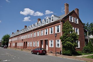
District E is a historic worker housing district in Manchester, New Hampshire, near the former Amoskeag Manufacturing Company millyard, at 258-322 McGregor Street on the west bank of the Merrimack River. It consists of five single-family houses, built in 1882 for overseers at the mills. It was added to the National Register of Historic Places on November 12, 1982.

The Broadway–Livingston Avenue Historic District is located at the junction of those two streets in Albany, New York, United States. It includes seven buildings remaining from an original 20, all contributing properties, and a Warren truss railroad bridge. In 1988 the area was recognized as a historic district and listed on the National Register of Historic Places.

Manchester, the largest city in New Hampshire, is made up of 25 neighborhoods, according to the Manchester Planning Board in its 2010 master plan. Recognition of particular neighborhoods varies, with some having neighborhood associations, but none have any legal or political authority.

The Nashua Manufacturing Company Historic District in Nashua, New Hampshire, is a historic district that was listed on the National Register of Historic Places (NRHP) in 1987. It encompasses an area just west of downtown Nashua, roughly located along the southern bank of the Nashua River, bordered on the west side by Mine Falls Park, on the south side by the Nashua River canal, up to Ledge Street, and from the east side by Factory, Pine and Water streets, up to the Main Street bridge.

2+1⁄2 Beacon Street, also known as the former New Hampshire State Prison Warehouse, is a historic commercial building at 2+1⁄2 Beacon Street in Concord, New Hampshire. Built in 1860 and enlarged in 1868, it is the only major surviving element of New Hampshire's first state prison complex, which was mostly torn down in the 1890s. The building was listed on the National Register of Historic Places in 1984.

The Hoyt Shoe Factory is a historic factory complex at 470 Silver Street and 170 Lincoln Street in Manchester, New Hampshire. It consists of two once-identical four-story brick factory buildings which face each other across Silver Street. Built in the 1890s, they housed the city's largest shoe manufacturer, an industry that gained in significance as its textile industry declined. The complex was listed on the National Register of Historic Places in 1985.

The Gen. John Stark House is a historic house museum at 2000 Elm Street in Manchester, New Hampshire. The house, a single-story Cape style farmhouse, was built in 1736 by Archibald Stark. Stark's son John, a hero of the American Revolutionary War, lived in this house from 1736 to 1765; it is where he brought his new bride Molly, and where two of their children were born. It was listed on the National Register of Historic Places in 1973. It is now operated as a museum by the local chapter of the Daughters of the American Revolution.

George W. Stevens was an American civil engineer and architect practicing in Manchester, New Hampshire, during the nineteenth century.