 |
|---|
The provinces of Panama and some of the comarcas are divided into districts (distrito). The district are further divided into corregimientos of Panama

| |
|---|
The provinces of Panama and some of the comarcas are divided into districts (distrito). The district are further divided into corregimientos of Panama
| | This article about the geography of Panama is a stub. You can help Wikipedia by expanding it. |

Chiriquí is a province of Panama located on the western coast; it is the second most developed province in the country, after the Panamá Province. Its capital is the city of David. It has a total area of 6,490.9 km2, with a population of 462,056 as of the year 2019. The province of Chiriquí is bordered to the north by the province of Bocas del Toro, to the west by Costa Rica, to the east by the province of Veraguas, and to the south by the Pacific Ocean, specifically the Gulf of Chiriquí.

Panamá is a province of Panama. It is the location of the national capital Panama City, which also serves as the provincial capital. The governor of the province is Judy Meana, appointed by President Laurentino Cortizo and sworn in on 16 April 2020.


Barú District is a district (distrito) of Chiriquí Province in Panama. The population according to the 2000 census was 60,551. The district covers a total area of 589 km². The capital lies at the city of Puerto Armuelles.

San Miguelito is a city and district (distrito) of Panamá Province in Panama. The population according to the 2000 census was 293,745; the latest official estimate is 375,409. The district covers an area of 50.1 km². San Miguelito district is completely enclaved within Panama District and it is included in the Panama City Metropolitan Area.

Soná District is a district (distrito) of Veraguas Province in Panama. The population according to the 2010 Panamanian census was 27,833; the latest official estimate is 29,774. The district covers a total area of 1,519 km². The capital lies at the city of Soná.

San Francisco District is a district (distrito) of Veraguas Province in Panama. The population according to the 2010 Panamanian census was 9,881; the latest official estimate is 10,536. The district covers a total area of 437 km2. The capital lies at the town of San Francisco.

Las Tablas District is a district (distrito) of Los Santos Province in Panama. The population according to the 2000 census was 24,298. The district covers a total area of 698 square kilometres (269 sq mi). The capital lies at the city of Las Tablas.

Arraiján is the district (distrito) of West Panamá Province in Panama. The territory lies west of the Panama Canal bordering Panama City. The population according to the 2000 census was 149,918; the latest official estimate is 296,188, with many suburban communities for commuting workers of Panama City. The district covers a total area of 418 km². The district seat is Arraiján city.
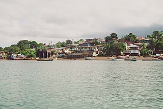
Balboa is an island district (distrito) of Panamá Province in Panama, covering the offshore Pearl Islands lying in the Gulf of Panama southeast of Panama City. The population according to the 2000 census was 2,336; the latest official estimate is 3,332. The district covers a total area of 333 km². The capital lies at the town of San Miguel.

Chame is a district (distrito) of Panamá Oeste Province in Panama. The population according to the 2000 census was 19,625; the latest official estimate is 31,373. The district covers a total area of 377 km2. The capital lies at the city of Chame.

Chimán is a district (distrito) of Panamá Province in Panama. The population according to the 2000 census was 4,086; the latest official estimate is 3,531. The district covers a total area of 1,046 km². The capital lies at the town of Chimán.

Panamá is a district (distrito) of Panamá Province in Panama. The population according to the 2010 census was 880,691; the latest official estimate is 1,183,333. The district covers a total area of 2,031 km². The district seat is Panama City.

San Carlos is a district (distrito) of West Panamá Province in Panama. The population according to the 2000 census was 15,541; the latest official estimate is 24,001. The district covers a total area of 338 km².

Atalaya District is a district (distrito) of Veraguas Province in Panama. The population according to the 2000 census was 8,916; the latest official estimate ia 11,321. The district covers a total area of 156 km². The capital lies at the town of Atalaya.

Calobre District is a district (distrito) of Veraguas Province in Panama. The population according to the 2000 census was 12,184; the latest official estimate ia 12,159. The district covers a total area of 806 km². The capital lies at the town of Calobre.

La Mesa District is a district (distrito) of Veraguas Province in Panama. The population according to the 2000 census was 11,746; the latest official estimate is 12,052. The district covers a total area of 511 km2. The capital lies at the town of La Mesa.
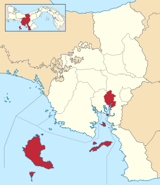
Montijo District is a district (distrito) of Veraguas Province in Panama. The population according to the 2000 census was 12,211; the latest official estimate is 7,060. The district covers a total area of 780 km². It includes all of the offshore islands of Coiba National Park, the largest of which are Coiba and Jicarón. The capital lies at the town of Montijo. The district includes the Gulf of Montijo and the islands in it.

Río de Jesús District is a district (distrito) of Veraguas Province in Panama. The population according to the 2000 census was 5,256; the latest official estimate is 5,501. The district covers a total area of 302 km2. The capital lies at the town of Río de Jesús.

Panamá Oeste is the newest province in Panama.